Argentina 2010
Descent to Santa Ana . . . January 21, 2010
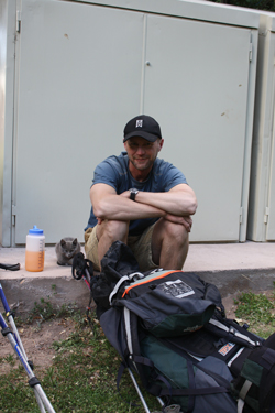
We were up by six a.m. and soon breaking down the tents and readying the last of the gear for the trip down by mule. The only thing we planned to carry ourselves were packs with an extra layer but more importantly, room for a couple of layers to go into the packs as we traded the high mountain valley climate we were now accustomed to for the hot dry desert below.
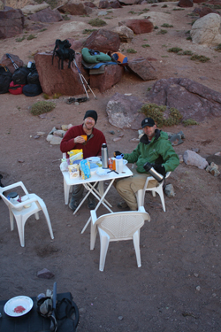 Manuel and Celeste may have broken down all the tents but they left no doubt that a hearty breakfast for everyone was in order as Manuel had a stove tucked behind a rock and was cooking the last of the eggs for all takers. And though the white dome was gone, the blue cook tent was gone, and all other semblances of the base camp were rapidly disappearing into heavy duffle bags, there remained a table, chairs, and the sense of style that Celeste and Manuel brought to the task. Manuel and Celeste may have broken down all the tents but they left no doubt that a hearty breakfast for everyone was in order as Manuel had a stove tucked behind a rock and was cooking the last of the eggs for all takers. And though the white dome was gone, the blue cook tent was gone, and all other semblances of the base camp were rapidly disappearing into heavy duffle bags, there remained a table, chairs, and the sense of style that Celeste and Manuel brought to the task.
 We finished breakfast and decided to get going as we knew we had a long walk ahead of us. I know I'd have rather gotten an earlier start for the simple reason that there was not a cloud in the sky and I knew that river was going to rise throughout the day. Before moving to Wyoming in 1998, I tucked 5 years of whitewater paddling under my belt on the Cheat, Youghagheny, Big Sandy and a number of other mid Atlantic classics. That experience, though short in years gave me comfort in Class IV water and a healthy respect for the ability of a river to do a job on a body in a few seconds flat. While mountaineering can provide many an opportunity to get banged up or seriously injured, I remember well our merry paddling group and the shared blood, broken foot, bruised parts and two dislocated shoulders. Needless to say, the prospect of crossing the Rio Colorado was not something I was looking forward to doing . . . seven times. We finished breakfast and decided to get going as we knew we had a long walk ahead of us. I know I'd have rather gotten an earlier start for the simple reason that there was not a cloud in the sky and I knew that river was going to rise throughout the day. Before moving to Wyoming in 1998, I tucked 5 years of whitewater paddling under my belt on the Cheat, Youghagheny, Big Sandy and a number of other mid Atlantic classics. That experience, though short in years gave me comfort in Class IV water and a healthy respect for the ability of a river to do a job on a body in a few seconds flat. While mountaineering can provide many an opportunity to get banged up or seriously injured, I remember well our merry paddling group and the shared blood, broken foot, bruised parts and two dislocated shoulders. Needless to say, the prospect of crossing the Rio Colorado was not something I was looking forward to doing . . . seven times.
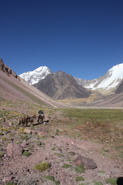
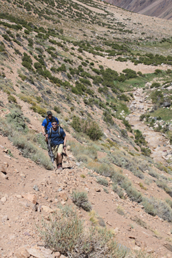
 We started down valley, again walking along the contact between the alluvium and the bank, taking advantage of the mule trail for the first mile or so. We ended up leaving at 8:45 and knew that the Canadians had spent more than 8 hours covering the distance from the Base Camp to the Approach camp, twelve miles and a few thousand feet lower. We hoped to make better time than they did or we would be facing the prospect of coming out on headlamps and doing the last crossings at the height of the evening flush. We walked for no more than fifteen minutes before we met the arriero coming up to gather our gear for the trip down. They had four pack mules and had obviously gotten an early start as they needed to make the entire trip to Santa Ana as well. We started down valley, again walking along the contact between the alluvium and the bank, taking advantage of the mule trail for the first mile or so. We ended up leaving at 8:45 and knew that the Canadians had spent more than 8 hours covering the distance from the Base Camp to the Approach camp, twelve miles and a few thousand feet lower. We hoped to make better time than they did or we would be facing the prospect of coming out on headlamps and doing the last crossings at the height of the evening flush. We walked for no more than fifteen minutes before we met the arriero coming up to gather our gear for the trip down. They had four pack mules and had obviously gotten an early start as they needed to make the entire trip to Santa Ana as well.
 After a mile or so the braided river channel is concentrated on river left by the start of a very large alluvial fan washed down from a side valley. The water in the river was already brown and the volume was building but there was no reason to give it much thought as our first crossing would not be for five miles or so. We crossed the lower part of the fan for about a half mile before climbing on up through the larger talus that forms a substantial mound built with the rock and soil eroded from one flank of la Ramada and washed into the Valle proper. After about 3/4 of a mile we'd crossed the mound, lost the trail a few times, pushed through a narrow barrier of trees and brush and arrived back on the gravel bank that on our ascent had marked our first views of Pico de Polocos. After a mile or so the braided river channel is concentrated on river left by the start of a very large alluvial fan washed down from a side valley. The water in the river was already brown and the volume was building but there was no reason to give it much thought as our first crossing would not be for five miles or so. We crossed the lower part of the fan for about a half mile before climbing on up through the larger talus that forms a substantial mound built with the rock and soil eroded from one flank of la Ramada and washed into the Valle proper. After about 3/4 of a mile we'd crossed the mound, lost the trail a few times, pushed through a narrow barrier of trees and brush and arrived back on the gravel bank that on our ascent had marked our first views of Pico de Polocos.
 We were making good time and soon enough we were up and over the small dry hillock that forms the upward terminus of the pasture like stretch that offered such a welcome break on our ascent for both the three of us as well and Celeste, Manuel and Multi-Presa. After a descent of 5 1/2 miles we traversed the flat top of another hill, which was keeping us about 100 feet above the river, and dropped down to the river 's edge. We had arrived at our first crossing of the day and it was still early enough that getting across would not be a problem. We did the presto chango of footwear, grasped our hiking poles and made our individual crossings to the other side. Once across we hiked another 100 yards up and over the bank to cross a small clear stream where we took a moment to swap footwear and re-fill our water bottles. We were making good time and soon enough we were up and over the small dry hillock that forms the upward terminus of the pasture like stretch that offered such a welcome break on our ascent for both the three of us as well and Celeste, Manuel and Multi-Presa. After a descent of 5 1/2 miles we traversed the flat top of another hill, which was keeping us about 100 feet above the river, and dropped down to the river 's edge. We had arrived at our first crossing of the day and it was still early enough that getting across would not be a problem. We did the presto chango of footwear, grasped our hiking poles and made our individual crossings to the other side. Once across we hiked another 100 yards up and over the bank to cross a small clear stream where we took a moment to swap footwear and re-fill our water bottles.
 The trail climbs away from the small stream and drops for two miles through the narrow canyon before traversing varied terrain that inlcudes the steep up and over hill, mule challenging talus and the slightly out of place patch of red desert that indicates one's arrival at the mid point of the decent and river crossing number 6. We were doing OK on water so we skipped a stop at the "turd spring" and dropped to the river to make our second crossing. We made this crossing without too much difficulty and stopped on the other side to have some of the sandwiches packed by Celeste and Manuel for lunch. Bob was at this point nursing painful ankle, more likely than not the result of the pace I had set on the descent. His discomfort was obvious and I slowed the pace accordingly. The trail climbs away from the small stream and drops for two miles through the narrow canyon before traversing varied terrain that inlcudes the steep up and over hill, mule challenging talus and the slightly out of place patch of red desert that indicates one's arrival at the mid point of the decent and river crossing number 6. We were doing OK on water so we skipped a stop at the "turd spring" and dropped to the river to make our second crossing. We made this crossing without too much difficulty and stopped on the other side to have some of the sandwiches packed by Celeste and Manuel for lunch. Bob was at this point nursing painful ankle, more likely than not the result of the pace I had set on the descent. His discomfort was obvious and I slowed the pace accordingly.
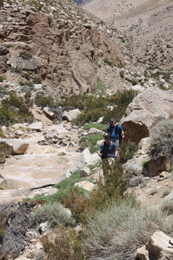 Our next crossing would not be for 1 1/2 miles of much more gentle terrain. We would lose but 500 feet over the distance much of which was sandy trail past the entry of a significant side canyon and then down through a tighter stretch the bottom of which is marked by house size boulders that seem out of place due to their composition being markedly different fro the surrounding cliffs. Regardless of my geologic fixation, we arrived at the anticipated hook in the river, ascended a slight rise and then dropped back down into a boggy vegetated stretch of river bank. We came to the point where we made our fifth crossing on the ascent but the mule track was so strong, we opted to continue for another 500 feet to the now obvious mule crossing. The mule crossing was well placed and again we traversed the river without problem. Our next crossing would not be for 1 1/2 miles of much more gentle terrain. We would lose but 500 feet over the distance much of which was sandy trail past the entry of a significant side canyon and then down through a tighter stretch the bottom of which is marked by house size boulders that seem out of place due to their composition being markedly different fro the surrounding cliffs. Regardless of my geologic fixation, we arrived at the anticipated hook in the river, ascended a slight rise and then dropped back down into a boggy vegetated stretch of river bank. We came to the point where we made our fifth crossing on the ascent but the mule track was so strong, we opted to continue for another 500 feet to the now obvious mule crossing. The mule crossing was well placed and again we traversed the river without problem.
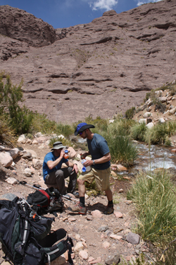 We were now starting to get a bit shy on water but we knew that the strong side stream that we stopped at on the way up was but a quarter mile away and that we could stop there to re-water and snack for a few minutes before going on. We dropped down the hill to the stream, found three different ways across that did not require a shoe change and sat down for a ten minute break. We were all doing well at this point and able to maintain a strong pace that precluded any thought of a dark finish to the descent. We rambled along the bank for the next quarter of a mile and came the point where we made our fourth crossing on the ascent but again there was a solid mule track that was showing no sign of crossing to the other bank. We were now starting to get a bit shy on water but we knew that the strong side stream that we stopped at on the way up was but a quarter mile away and that we could stop there to re-water and snack for a few minutes before going on. We dropped down the hill to the stream, found three different ways across that did not require a shoe change and sat down for a ten minute break. We were all doing well at this point and able to maintain a strong pace that precluded any thought of a dark finish to the descent. We rambled along the bank for the next quarter of a mile and came the point where we made our fourth crossing on the ascent but again there was a solid mule track that was showing no sign of crossing to the other bank.
There is no point in screwing up a good thing so we stuck with the strong trail and kept going for more than another half mile before the track we liked made a hard turn down the bank and crossed the river. We took the hint, swapped the feet and made another crossing, this time in deeper water that now was splashing to crotch height whereas we were dry at that height on the prior crossings. All crossed without 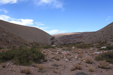 problem but we were transitioning from an upright stance to a noticeable upstream lean and the waist cinches were all loose for the crossings from here on out. We hiked a bit under one half mile to a point perhaps 400 to 500 feet past our third crossing on ascent and made our fifth crossing, again through deeper water but without incident. problem but we were transitioning from an upright stance to a noticeable upstream lean and the waist cinches were all loose for the crossings from here on out. We hiked a bit under one half mile to a point perhaps 400 to 500 feet past our third crossing on ascent and made our fifth crossing, again through deeper water but without incident.
We knew that the terrain would really mellow from here on as we would arrive at our first night's approach camp site in a half hour where we would again top off the water bottles and make our sixth crossing. We were soon trucking along through the grassy patch where we had camped over a week and half before on our first night in the Valle. We crossed for our sixth 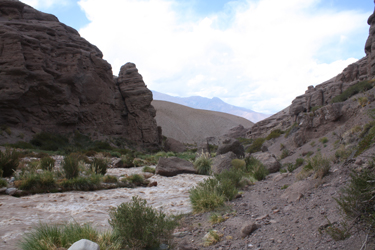 time and knew this spot would be a bit deep as it had been on our trip upstream and that was not that hot of a day. We picked a spot about 10 yards further upstream that offered but two small tongues to deal with in he crossing . . . no problems. We knew we now had to cover but six more miles to arrive in Santa Ana and our ride to Barreal so we got going on down the trail. time and knew this spot would be a bit deep as it had been on our trip upstream and that was not that hot of a day. We picked a spot about 10 yards further upstream that offered but two small tongues to deal with in he crossing . . . no problems. We knew we now had to cover but six more miles to arrive in Santa Ana and our ride to Barreal so we got going on down the trail.
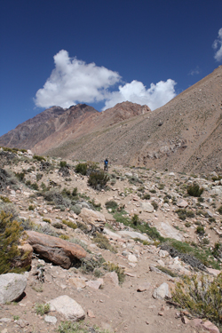
We had not seen any sign of the mules or Celeste and crew but given that Celeste is a bit on the short side, we figured they might be descending together so she could hitch a ride across the river on the mules. We found out later that such was not the case and that they in fact stuck to one bank and made the descent with but two crossings. We had settled into a 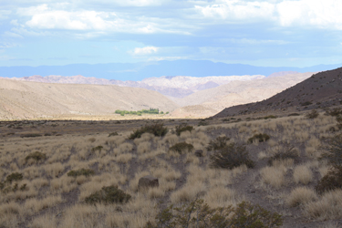 steady pace and were making a bit over two miles per hour. While the terrain would have allowed for a faster pace, we were all feeling good and there was no reason to go any faster through what was now a very different territory than above. We had traded the high alpine valley for the "Nevadaesque" high desert through which the trail to Santa Ana now lead. steady pace and were making a bit over two miles per hour. While the terrain would have allowed for a faster pace, we were all feeling good and there was no reason to go any faster through what was now a very different territory than above. We had traded the high alpine valley for the "Nevadaesque" high desert through which the trail to Santa Ana now lead.
We covered about 3 miles before we exited the final canyon portion of the route and began our traverse of the much flatter alluvial plain on which Santa Ana sits. The day had gone from a cool morning just above freezing to a desert hot afternoon, thankfully one with a cloudy sky. The trail now qualified as hot but not nearly as hot as it would have been had the sun made 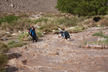 an appearance. Then we spotted the trees that marked the Santa Ana outpost but the GPS told the truth . . . that we were still over two crow fly miles from that clump of green that seemed so close. However, we were on a strong trail, unlike our passage through this area on the ascent, and an hour later we cut left off the trail to make our final crossing at the same point that we used before. Celeste had warned that the final crossing of the day should be done before 4 p.m., after which it became very difficult due to the water level. We arrived at the crossing and the knee deep crossing of the ascent had become a turbulent waist deep crossing. Not only was the water deep but one could literally hear the rounded stone cobbles being rolled down stream by the current. an appearance. Then we spotted the trees that marked the Santa Ana outpost but the GPS told the truth . . . that we were still over two crow fly miles from that clump of green that seemed so close. However, we were on a strong trail, unlike our passage through this area on the ascent, and an hour later we cut left off the trail to make our final crossing at the same point that we used before. Celeste had warned that the final crossing of the day should be done before 4 p.m., after which it became very difficult due to the water level. We arrived at the crossing and the knee deep crossing of the ascent had become a turbulent waist deep crossing. Not only was the water deep but one could literally hear the rounded stone cobbles being rolled down stream by the current.
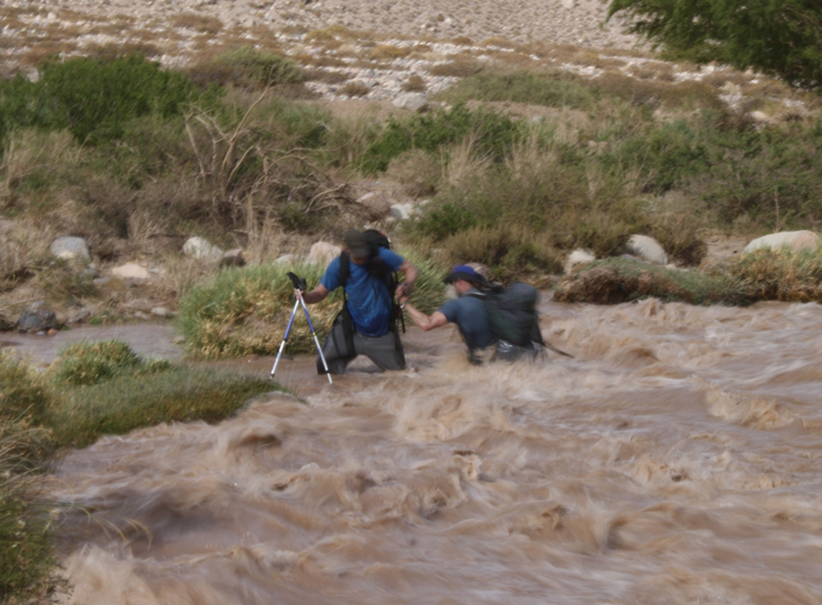
 We looked at our prior line and it proved, at first blush too deep for G's tastes. G has three inches and 35 lbs on me so I figured if he did not want to take it on, I was going to look for another point. Upstream about 75 feet there was a wider stretch with consistent flow, meaning no constructions or tongues . . . I'd found the point that I would use to get across. I loosened the pack for easy escape and really leaned into those poles. The water was swift, the fastest yet but I made the crossing without too much trouble. Once across, I looked downstream to find that G had taken a second and successful shot at the original crossing point and that Bob was following his lead. Bob was nearing the bank, when he ran into trouble and started to go down on a hip into the water. G reached out and pulled him to the bank, averting a swim. We looked at our prior line and it proved, at first blush too deep for G's tastes. G has three inches and 35 lbs on me so I figured if he did not want to take it on, I was going to look for another point. Upstream about 75 feet there was a wider stretch with consistent flow, meaning no constructions or tongues . . . I'd found the point that I would use to get across. I loosened the pack for easy escape and really leaned into those poles. The water was swift, the fastest yet but I made the crossing without too much trouble. Once across, I looked downstream to find that G had taken a second and successful shot at the original crossing point and that Bob was following his lead. Bob was nearing the bank, when he ran into trouble and started to go down on a hip into the water. G reached out and pulled him to the bank, averting a swim.
Bob had been doing well until one of those cobbles clipped his leg and tore off his Teva. That cost him his balance but G's intervention saved the day. Bob sat on the bank, took off his remaining Teva and tossed it into the current, we'd made our last river crossing. Once the feet were dry and the boots back on, we hiked along the tree covered terrace toward the gendarme post. The high afternoon water now flowed across the terrace through a number of irrigation ditches that slowly peter out and spread their substantial flow across the ground. We found a mostly dry course that led us to the far left bank where there was a solid track leading right to the guard post.
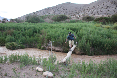 We had still seen no sign of the mules or Celeste so we dropped our packs and took a break in the grassy yard of the border post. We finished off the second of the two sandwiches Manuel had prepared for the day, part of which I ended up sharing with one cat and three dogs whose ribs told me that they would be interested in any handouts forthcoming. We rested for a few more minutes before walking the quarter mile to the ford that we knew would be impassible for any vehicle short of a 6x6. We looked across the river to see if Fernando had arrived yet and he had not. We pumped some water to drink and wandered on back to the shade of the guard post to await the arrival of the mules and Celeste. After about an hour the mules passed through and made their way to the log bridge that would provide a crossing point to the other side where Fernando was now waiting. After a few minutes Celeste arrived and we made our way to the log bridge and across to the waiting Land Rover and a cold beer for each arrival, courtesy of Fernando. We had still seen no sign of the mules or Celeste so we dropped our packs and took a break in the grassy yard of the border post. We finished off the second of the two sandwiches Manuel had prepared for the day, part of which I ended up sharing with one cat and three dogs whose ribs told me that they would be interested in any handouts forthcoming. We rested for a few more minutes before walking the quarter mile to the ford that we knew would be impassible for any vehicle short of a 6x6. We looked across the river to see if Fernando had arrived yet and he had not. We pumped some water to drink and wandered on back to the shade of the guard post to await the arrival of the mules and Celeste. After about an hour the mules passed through and made their way to the log bridge that would provide a crossing point to the other side where Fernando was now waiting. After a few minutes Celeste arrived and we made our way to the log bridge and across to the waiting Land Rover and a cold beer for each arrival, courtesy of Fernando.
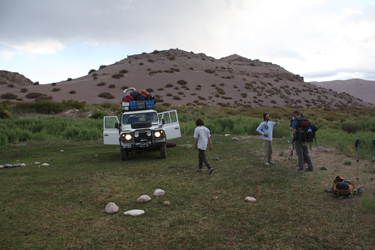 The gear was on board and we loaded everyone up in the Rover for the trip to Barreal. We drove the rough double track for three miles or so before hitting the better dirt road leading to the mining company bridge after about seven miles. We crossed the bridge and stopped at the check point where we were logged out and the red and white pole was raised so we could pass on to Barreal. We passed through the winding up and down stretch through the canyon before the sun set and we completed the trip in the dark, partly due to the time and partly due to the substantial thunderstorm that had settled in the area and which would dump on us upon our arrival in Barreal. Lightning lit up the sky over and over as we drove the 20 miles of road to Barreal and to our overnight accommodations at the Posada San Eduardo. The gear was on board and we loaded everyone up in the Rover for the trip to Barreal. We drove the rough double track for three miles or so before hitting the better dirt road leading to the mining company bridge after about seven miles. We crossed the bridge and stopped at the check point where we were logged out and the red and white pole was raised so we could pass on to Barreal. We passed through the winding up and down stretch through the canyon before the sun set and we completed the trip in the dark, partly due to the time and partly due to the substantial thunderstorm that had settled in the area and which would dump on us upon our arrival in Barreal. Lightning lit up the sky over and over as we drove the 20 miles of road to Barreal and to our overnight accommodations at the Posada San Eduardo.
We arrived at the Posada at about 10 p.m. and were soon provided with a cool high ceilinged room, three beds and bath. After our nearly two weeks in the Valle de Colorado, this looked wonderful and I'll vouch for the Posada San Eduardo. Not only was the room a keeper but we got there before the end of the dinner hour (11:00 p.m. in Argentina) and were invited to the dining room for a great filet and veggie dinner. If I again find myself in Barreal, I know where I'll overnight . . .
|
