|
||||||||||||||||
|---|---|---|---|---|---|---|---|---|---|---|---|---|---|---|---|---|
Banff Assiniboine Expedition IAugust 11, 2002 – Approach to Mount Assiniboine
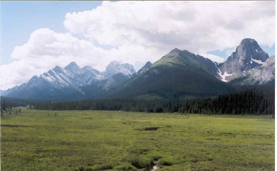
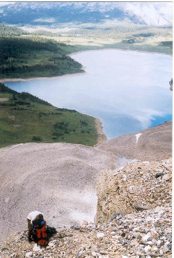
Jim and I broke camp by 7 a.m. and I started preparing for the approach to Mount Assiniboine. First on the list was getting Jim’s rental gear back to the shop, next a touch of breakfast, a grocery shopping trip for the next few nights outside and finally dropping Jim off at the bus station for his ride to Calgary. I met Gary and Diana back at the campground and we picked up a few final food items before heading for the Mount Shark heliport. Some quick background: Mount Assiniboine is located in neighboring British Columbia in Mount Assiniboine Provincial Park. There is no road access to the park or the peak so one must choose between a 17 mile one way hike and a ten-minute helicopter ride, available three days of the week. Though a traditionalist at heart, I and the rest of the group chose the chopper ride due to time constraints. The cost is quite reasonable and worth it for at least one direction just to get an aerial view of the incredible mountain scenery that comprises the surrounding park.
Hustle we did, as there was barely enough time to get everything done and then make the one hour ride down the gravel forest access road to the helicopter pick up point. The ride to the pad is fantastic though only once do you get a glimpse of Assiniboine, an impressive spire sticking up amongst more rounded but by no means tame peaks. We made it just at the 11:30 appointed time and checked in with the Assiniboine Lodge staff running the show. The Assiniboine Lodge is a concession located on the shore of Lake Magog, which provides high-end lodging, booked many months in advance and administers the Hind Hut and the Naiset Cabins. The Hind Hut is an alpine climbers hut located above the headwall that forms the primary obstacle to an Assiniboine approach. It sleeps 15 in two bunks and has a stove and decent water source. The Naiset Cabins are adjacent to the Lodge and provide bunks for six with foam pads and a wood stove, should the temperatures drop.
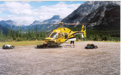
We placed our packs on the scale and found that we were over the 40 lb. free baggage allowance for the flight in. The bags still go, but you pay an extra $1 per pound over 40. Dianna was OK with her 39 lbs. but my load came in at 52 lbs. and Gary topped out at 62 lbs. We just shrugged once again and tried to convince ourselves that it was all food weight and we would eat enough to arrive at daypack weight in just a few days. We took our place in line and about an hour later, we were climbing aboard one of the two helos flying the quick run up the valley to Assiniboine. The ride is wonderful as you fly across lakes and up Bryant creek, passing by the steep cliffs of the glaciated valley the forms the approach. At the end, Assiniboine comes into view, its characteristic flat north face, leaving no doubt that some degree of climbing challenge will lay ahead, regardless of the route chosen.
We went back to the landing pad and gathered our bags after the chopper took off and checked with Joe (his real name) the Park Ranger about our Hut and Cabin accommodations. The guidebooks say that the cabins and hut are first come first serve but in fact, they are anything but that. We found out only 4 days before the climb that reservations could and should be made and were able to confirm all nights for three persons except one hut night. In light of this possible glitch, we did haul in a Bibler tent and sleeping pad for one person who might end up on the ground outside of the Hind Hut. Fortunately, Joe was an understanding guy and he slid one more person into the hut for one night, something, for which we were seriously thankful. Not that the ground is that bad, but instead he saved us the weight of hauling a tent up the Assiniboine headwall approach.
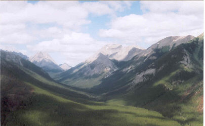
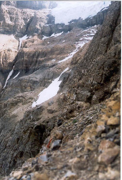
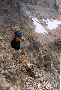
Having lost a bit of weight, we hefted the packs for the walk past the Lodge, along the length of Lake Magog, and up a route through the headwall cliffs called Gmosers Highway. The hike along the lake was self-explanatory though the trail does braid through the campground, eventually depositing one at the scree covered base of the headwall. For anyone thinking that Gmosers Highway is the Canadian equivalent of perhaps Colorado’s Kit Carson ledge, there will be a rude surprise. These Canadian peaks just do not see the traffic of the climbs in Colorado or likely elsewhere in the States. That means that this route, like every route we were on, is cairned here and there, maybe, or maybe not, sparingly at the very best. You have to be able to spot a trail trace, see where other’s footfalls have worn the lichens off the rock, or otherwise use previously developed mountaineering know how to find the route. Gmosers highway was an exercise in applied route finding and skilled movement over rock learned through many a Colorado climb.
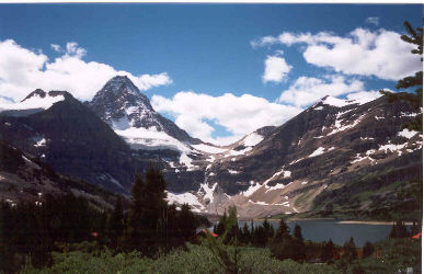
The highway is a long class 4 route that had to be negotiated with a 52-pound pack, in my case. For Colorado readers, it is the equivalent of climbing the last 500 feet of Pyramid with a fully loaded pack and an equivalent amount of exposure. Pyramid, you do have to be kidding? Seriously, it is an exercise in travel on ledges covered in loose rubble in an effort to scale a similarly bedded sedimentary mountain. We climbed the first 30-foot chimney and then made our way up a scree gully to a snowfield traverse to a higher ledge system. The higher ledge system moved up and down and was as narrow as one foot in a memorable spot or two. This is definitely no slip territory as the ledge traverse, from almost the start, is above a cliff band that would not be something one wants to tangle with. The traverse continues and requires a series of class 4 moves until the width of the headwall is covered and one arrives at the base of a 45 degree 200 foot high snowfield leading to the final scree slog and the top of the headwall. We were late in the afternoon at this point and previous parties had kicked good steps in the snow. We broke out the ice axes, made our way up the slope, and then slogged the loose section to finally top out.
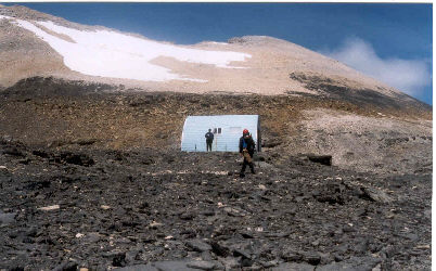
The Gmosers Highway traverse took us two hours to complete and involved some backtracking to ensure we were on route and some very careful foot placement to ensure that we did not suddenly depart from the route. The final scree filled gully also introduced us to a factor that would play a significant part in the rest of the climb: rock fall. This peak is covered in loose crap and there are more than enough downward sloping ledges to assist you in letting loose a bit or a boulder onto a party below. Caution was the watchword of the day, as mis-steps would start a slope moving with very little effort. Atop the last gully are the moraines associated with the past progress of the Assiniboine Glacier and further up, on a dark rock shoulder, is the Hind Hut. We reached the hut at about 5:30 in the evening and were the last “reserved” group to arrive.
The hut is a Quonset like structure with capacity for 15 climbers. There are three stove burners and two bunks; it is an exercise in spontaneous cooperation. There are foam pads on the bunks and more than enough pots, pans, and plates to meet the needs of those staying there. The Assiniboine Lodge info sheet says that one does not have to carry the extra weight of sleeping pads and cookware and that turned out to be accurate. We introduced ourselves to the rest of the climbers, a group from Alberta and another from British Columbia, made dinner and headed for the bunks by 8 p.m. The last group in that night arrived around 8:30, a group of four Brits who were unaware of the reservation system (guidebook was wrong) and they too crowded into the hut, two on bunks and two on the floor. Not the best of arrangements but after some initial chill, everyone realizes that those who make it to the hut for a climb of Assiniboine are likely decent climbers and room can generally be found somewhere, though without any guarantee of comfort.
|
