|
||||||||||||||||
|---|---|---|---|---|---|---|---|---|---|---|---|---|---|---|---|---|
Mount Massive and North MassiveJune 12, 2001 & July 13, 2003 - From Halfmoon Lakes
Somehow, Mount Massive had eluded me when I climbed most of the Sawatch in previous years and now I was back to tick this one off the list with a snow climb. I chose the Halfmoon Lake route and camped the night before along the road leading to the trailhead. The road heading to the trailhead is good, I easily drove it with a small 4WD, and I was the only vehicle parked at the terminus at five a.m. the next morning. The trail heads off along the creek, which is good because at this time of year, getting across the creek would have been a real neat trick. I had no problem route finding and made good time going up to the snow line, which was just above the Halfmoon Lakes. Having climbed the route and looked at the photos in the guidebook, I should have been able to pick out the correct drainage to climb to get to Mount Massive proper. I say that now that I have made the climb. Unfortunately, I needed to better observe the fine details in Dawson’s photo which is well done but the most obvious trail led me up the drainage below North Massive, not the Massive I was seeking to climb. Regardless, on up I went on a mix of snow and rock and finally straight snow to the ridgeline, which given the nature of the Massives is really a long summit ridge.
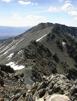
Topping out on the climb placed me on a snowy flat looking up at an obvious summit. I kept moving and perhaps ½ hour later, I was on top. However, something was not right, either the topo was whacked, or I was not on Massive proper. Actually, it took all of about 2 seconds to figure out that I had skewed over one drainage and now was standing atop North Massive looking over to Massive and South Massive in the distance. At about this time, a Colorado Guard Blackhawk appeared and then another arrived, circling the area extending from my location to a few miles north. One at a time, each came to a hover over my position and I would presume checked me out to determine if I matched the description of whoever they were looking for. Two separate checkouts and then they seemed to occupy themselves to the north. I looked at the route to get to Massive and it involved a pitch or two of solid Class 3 down climbing and then a long traverse of the ridge to the saddle separating North Massive from Massive. Later, overlooking this saddle, the trail that I had meant to take, obviously topped out right where it was supposed to. I crossed the saddle and stopped once again to be scoped by the SAR crews who were likely repeating their comparison between their description and me and trying to decipher what a lone climber atop Massive shrugging his shoulders at them really means.
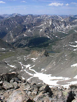
I made my way to Massive’s summit and even entertained the idea of a triple play but that was not in the itinerary left at home in case of a failed call in. After all, those helicopters were not burning fuel for nothing and though I was not the center of their attention, I had no desire to become so. Stick to the written plan left with my wife is my cardinal rule. I took the proper route down and in hindsight; it would have been a lousy ascent, no snow and lots of loose talus. Moving talus, not scree, and that meant that the long snowy route was certainly the best unintentional move that day. From snowline on back to the truck was just a well-trodden trail march and the combination of Massive and North Massive took about nine hours.
Two years later . . . Ed was looking for a partner to tag along on his effort to complete the 14’ers and suggested we go to Massive using the less traveled route I had used two years before. We met at the Foss Drug parking lot in Golden and after a quick gear transfer to my truck, we were on our way to Leadville. The trip up was quick and with little traffic but I was already dreading the thought of the trip down on Sunday afternoon. Massive would be my first 14’er in over a year and I had gotten used to staying north of I-70 in the relative backwaters of the Mummy Range or venturing south only during the spring and fall traffic off seasons. Regardless, our climbing circle has a Canada trip coming up so conditioning overcame the thought of the Georgetown/Idaho Springs Gauntlet.
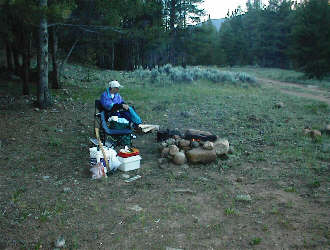
We stopped at the Leadville Safeway store and bought the makings of a pre climbing dinner, beef, potatoes, and corn on the cob, all of which were destined for my grill over a campfire. The past fire seasons had put a real cramp on my campfire cooking practice and I hoped that I could prepare this meal with a better outcome than I had in the Black Hills six weeks earlier, when I managed to immolate a half a dozen brats and destroy a pound of hamburger. Ed had yet to experience my cooking so he was either in for a half way decent meal or a hard to fight back desire to terminate my duties and return to Leadville. We found a camp spot just past the stream gauging station and after putting up the tent, I set to work on the evening meal. Fortunately for Ed, I managed to pull off the steaks and corn, but the potatoes did leave a bit to be desired. Regardless, we were in the tent by ten and hoped to get an early start, I say hoped as neither of us remembered a clock or watch with an alarm.
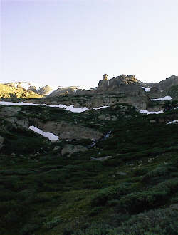
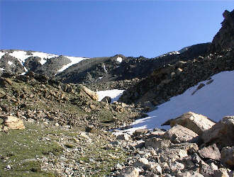
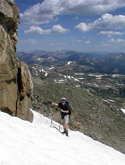
We woke to the first light at around 5 am and after some debate over dawn vs. moonlight, we started getting ready to go at about 5:15. We drove on up the road, passing an incredible number of commando campers until we realized that a USFS/Volunteer effort was encamped to work on trail(s) in the area. We found a parking spot at the trailhead and set out toward the Halfmoon Lakes at 6 a.m. The trail along the creek was as I remembered it and I set a steady pace for the head end of the valley where we would start to gain elevation more seriously. We arrived at the start of the real climb and this time intentionally took the left drainage when viewing the dividing ridge with the obvious tower mentioned in Dawson’s guide. My earlier trip took the same route and I knew from the descent two years before, that I wanted no part of the climb up the Dawson route to the saddle between Massive and North Massive. This time we would intentionally aim for Massive Green, using the gentle snow slopes still remaining to avoid the scree on the steepest part of the climb.
We climbed through the headwall just to the left of the towered ridge and took trial segments up through the increasingly larger boulders before breaking right to slog up a short talus and scree strewn slope to gain the base of the snow. Once on the snow, we made good time and soon crested onto the flat ground of Massive Green. The summit of North Massive is but a walk up/slight scramble from there and about ½ hour later we topped out. After taking a moment to drop our packs, I approached a group of a dozen climbers and bummed some sunscreen off them to slow down the burn that both Ed and I were well on the way to acquiring. You see, between the two of us, we have 80 14’er climbs so not having sunscreen was not mere negligence but more attributable to stupidity and lack of forethought.
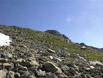
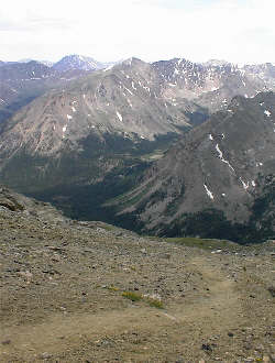
The route to Massive proper involves a downclimb with a class 3 or 4 segment should that be to your liking and then a ridge traverse over intermediate bumps until you eventually reach the next summit. We climbed and strode along the boulder strewn ridge until we again stood among another group of climbers on the highest of Massive’s multiple summits. Some photos and some food were taken and then we headed off in the direction of South Massive to take the direct trail Dawson mentions as a real knee killer. It was and by the time we got to the creek far below, both of us were hurting in the knees and thankful that my route finding error of years gone by resulted in the privilege of not choosing to ascend our descent route. From the bottom, it was but a fast walk to the truck and then a short drive to the tent to break camp and head home. And did the traffic on I-70 rise to my expectations? Of course it did . . .
|
