-
Mt. Bierstadt Group Summit - Front Range, Colorado
-
A rest before the summit push on Dallas Peak - San Juan Range, Colorado
-
Broken Ankle + 6 Miles = Tired
-
The classic San Juan approach - San Juan Range, Colorado
-
Overlooking Noname Basin from Twin Thumbs Pass - San Juan Range, Colorado
-
Upper Noname Basin - San Juan Range, Colorado
-
Nearing Noname Cabin - San Juan Range, Colorado
-
Twin Thumbs Twins - San Juan Range, Colorado
-
Nearing the summit of Pt. 13,736 - Sawatch Range, Colorado
-
Blustery day on Iowa Peak - Sawatch Range, Colorado
-
Morning snow at 15k, Cerro Ramada - Cordillera Ramada
-
Artesonraju from the summit of Nevado Pisco - Cordillera Blanca, Peru
-
February crowds on Gray's Peak - Front Range, Colorado
-
Kicking steps on Cerro Lliani - Cordillera Vilcanota, Peru
-
Final traverse to the summit of Wheeler Mountain - Ten Mile Range, Colorado
-
The long walk to Pachanta - Cordillera Vilcanota, Peru
- banner31
Afternoon at 17k on Cerro Ramada - Cordillera Ramada, Argentina
- banner22
The final ridge on Iowa Peak - Sawatch Range, Colorado
-
Summer summit on Longs Peak - Front Range, Colorado
-
A rest day at the Pachanta Hot Springs - Cordillera Vilcanota, Peru
-
Mind over matter on Mt. Parnassas - Front Range, Colorado
-
Rest stop on Cerro Lliani - Cordillera Vilcanota, Peru
- banner30
Post nap surprise on Cerro Ramada - Cordiller Ramada, Argentina
-
Summit on Cerro Lliani - Cordillera Vilcanota, Peru
- banner23
Ridge walking on Grizzly Peak - Sawatch Range, Colorado
-
Enroute the summit via the West Ridge on Pacific Peak - Ten Mile Range, Colorado
-
Mule train bound for Chilca - Cordillera Vilcanota, Peru
-
Taking in the view from Fletcher Peak - Ten Mile Range, Colorado
-
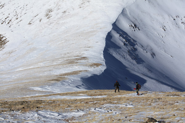
Hiking on Silverheels - Mosquito Range, Colorado
-
Traversing! Gladstone Peak - San Juan Range, Colorado
- banner24
The best of times at Willow Lake - Sangre de Christo Range, Colorado
- banner29
High Altitude Cerebral Edema? - Cordillera Ramada, Argentina
-
Bound for Chilca - Vilcanota Range, Peru
-
Going alpine light, Holy Cross Ridge - Sawatch Range, Colorado
-
Cumbre! Campa I - Cordillera Vilcanota, Peru
-
Roadside lunch with the best of company - Cordillera Vilcanota, Peru
- banner25
Long ridge walk to the summit of California Peak - Sangre de Christo Range, Colorado
- banner28
Crossing el Rio Colorado . . . in the afternoon - Cordillera Ramada, Argentina
- banner37
Dealing with Fall snows high on Casco Peak - Sawatch Range, Colorado
-
Moonrise over Mercedario - Cordillera Ramada, Argentina
-
Still climbing at 20,900 on Cerro Ramada - Cordiller Ramada, Argentina
-
Talus on Halo Ridge, Mt. of the Holy Cross - Sawatch Range, Colorado
- banner26
Deteriorating conditions on Mt. Arkansas - Ten Mile Range, Colorado
- banner27
After the climb - Cordillera Ramada, Argentina
- banner38
Taking in the view from the summit of Crystal Peak - Tenmile Range, Colorado
-
Topping out on Mt. Arkansas' North Couloir - Mosquito Range, Colorado
-
Glissade on Mt. Arkansas - Mosquito Range, Colorado
-
Hard snow morning on Teakettle Mountain - San Juan Range, Colorado
-
Spring snow announces the start of the climb on Dallas Peak - San Juan Range, Colorado
-
Crossing the Eolus Catwalk - San Juan Range, Colorado

 We made it to Hoosier Pass in a bit over 3 hours with a necessary stop to dehydrate and re-hydrate. We arrived at the pass in daylight and were pleased to see that the sun had just hit the parking area. We put on the cold weather gear and after about 20 minutes, we locked the car and crossed the highway to start up the trail on what was still a chilly 7 degree morning. I'd heard that an approach from Hoosier Pass would get us above tree line very quickly and that was apparent as we walked a well packed snowshoe/ski trail that led through a few hundred yards of woods before leading into a field of willows guarding the open slopes above.
  The trail provided a direct route through the willows and within another couple of hundred yards we were above the willows and heading steadily up slope. Silverheels was still not in sight but we knew we first had to gain Hoosier Ridge before we would see the peak and glimpse the terrain we would have to cross. The route to the ridge was semi beaten down, both by wind and the foot falls of earlier climbers seeking the same summit. We zigged here and there but generally made a pretty direct course to the ridge.
  I've generally heard that Silverheels is a big mountain and yes, it really is big. Not only that but it is a good distance from Hoosier Ridge to the beginning of the Silverheels climb proper. To get to that starting point, we traversed to the right of the prominent hump on Hoosier Ridge and then dropped down a southern spur to intentionally lose altitude and gain the base of the more western of Silverheel's north flank spurs. We descended to the base of Scott Gulch, crossed the frozen creek and started to climb. Once across the creek, we waged war with a small band of willows guarding the far bank and then stepped into an equally tenacious swath of knee deep powder before I was able to zig here and there to gain some ground with grass showing through.
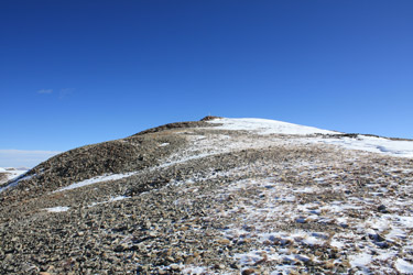 My plan was to connect grassy patches until I made the ridge proper. The climb to the ridge is a good 1000+ feet so I picked my way through grassy zones connected by wind hammered patches of snow. We climbed ever higher through thinning snow to reach Silverheel's summit ridge. The upper ridge was a gentle snow free walk and the three of us kept up a steady pace to reach the summit around noon. The sky was blue but for a small cloud here and there and when we reached the summit, the air was nearly still . . .
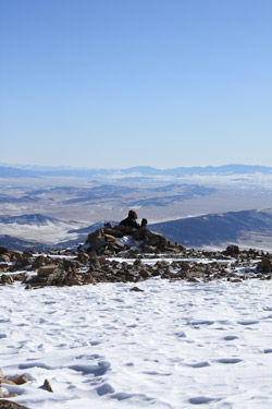 We ate a small snack and after about 15 minutes it was time to head down. The wind, in the meantime, had come up right nicely, and with it, the promise of enough wind chill to freeze the mustache and make the windward eye weep a bit. We knew that a retreat down our ascent route would only guarantee us the opportunity to re-climb the long spur we had used to drop off of Hoosier Ridge. Alternatively, we could cut down a bit sooner and follow the spur and subsequent serpentine ridge that separates Scott Gulch from Purgatory Gulch. That route would also give us plenty of up and down action to further the conditioning regimen. This route was much more to our liking and soon we were dropping down a path much steeper than our ascent route that seemed well trod by the mountain goats and big horn sheep we had seen on our ascent.
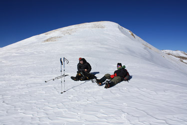 back to Hoosier Ridge and kicked a set of steps up a short section of wind hammered snow to gain the flatter ridge behind. From there we moved smartly along Hoosier Ridge, up and over a hump or two and then on back down our ascent slope to the willow and woods below. The warmth of the car now lay within sight and soon enough we were thinking more about a burger in Breckenridge than how we were going to get the warmth back in our fingers.