2006 Apolobamba Expedition
Trek from Lake Kotani to Piedras Grandes Camp
 A full travel day lay ahead of us so we were all up and oriented for an 8 a.m. departure. We knew we had a long way to go when Alcides noted that we would arrive at Piedras Grandes at about 4 p.m. and when Alcides states the time of arrival, it in no premonition. A full travel day lay ahead of us so we were all up and oriented for an 8 a.m. departure. We knew we had a long way to go when Alcides noted that we would arrive at Piedras Grandes at about 4 p.m. and when Alcides states the time of arrival, it in no premonition.
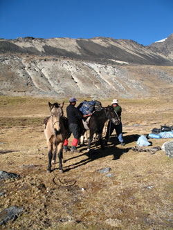
We broke the individual tents and gathered the gear in a pile near where Alcides would bring the horses. Where the horses were was a good question but we knew that we had seen them up toward the base of the Sunchuli ridge two days before and spotted one of them when we came down from Posnansky. We heard Alcides get up early and knew that he was hunting for three horses that were somewhere in the area above the lake.
 We piled the gear and then helped Mario break down the pyramid tent and gather some of the communal gear. Alcides arrived with three horses in tow and did what we now know arrieros do when it comes time to pack the train, take all the gear out of the bags, re-arrange it, and pack it to their liking. No problem by us, we've been down that road many a time in the past so we paid his re-arranging everything no mind. Arriereos are a picky bunch by nature and I think it is best to pile the gear and stand back, no point in cramping their style. We piled the gear and then helped Mario break down the pyramid tent and gather some of the communal gear. Alcides arrived with three horses in tow and did what we now know arrieros do when it comes time to pack the train, take all the gear out of the bags, re-arrange it, and pack it to their liking. No problem by us, we've been down that road many a time in the past so we paid his re-arranging everything no mind. Arriereos are a picky bunch by nature and I think it is best to pile the gear and stand back, no point in cramping their style.
 Once the three horses were loaded, we were off to regain the trail that traverses the side of Lago Kotani and climbs toward the crest of the headwall that starts the drop to the valley below. We passed through the stone wall and gate and started on down the myriad of llama trails that lead back down to the concrete bridge in the valley proper, just blow Paso Piedras. The hike out of the valley to the east of Cololo takes a long hour on the down hill before you arrive at the main trail and move on down hill toward the hamlet of Quimsa Cruz. The trek from the bridge to Quimsa is well traveled and passes first by a few farmsteads before the gorge tightens and takes a more curvy route to Quimsa. Once the three horses were loaded, we were off to regain the trail that traverses the side of Lago Kotani and climbs toward the crest of the headwall that starts the drop to the valley below. We passed through the stone wall and gate and started on down the myriad of llama trails that lead back down to the concrete bridge in the valley proper, just blow Paso Piedras. The hike out of the valley to the east of Cololo takes a long hour on the down hill before you arrive at the main trail and move on down hill toward the hamlet of Quimsa Cruz. The trek from the bridge to Quimsa is well traveled and passes first by a few farmsteads before the gorge tightens and takes a more curvy route to Quimsa.
 Quimsa is but a half dozen buildings and lays at the mouth of the valley that separates the northern half of the southern Apolobamba from the southern half of the Southern half. Sounds a bit like a land description from a surveying course but a look at any map of the Apolobamba will illustrate that this description makes sense. We had gotten well ahead of the mulas so stopped for a break and a touch of sun. When Alcides and Mario caught up, we too were off again, crossing another concrete bridge over a steam and then skirting the side of the far hill, past another hamlet and multiple llama corrals before arriving in Illo Illo. Quimsa is but a half dozen buildings and lays at the mouth of the valley that separates the northern half of the southern Apolobamba from the southern half of the Southern half. Sounds a bit like a land description from a surveying course but a look at any map of the Apolobamba will illustrate that this description makes sense. We had gotten well ahead of the mulas so stopped for a break and a touch of sun. When Alcides and Mario caught up, we too were off again, crossing another concrete bridge over a steam and then skirting the side of the far hill, past another hamlet and multiple llama corrals before arriving in Illo Illo.
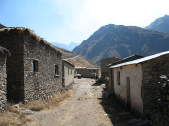 Illo Illo is the only pueblo on the route from Pelechuco to Curva and I would guesstimate the in town population at perhaps one hundred, two hundred at the most. There is not much in Illo but for a school and a central plaza with a few tiendas selling the most basic items. The curious thing is the notation on the outside of the stores that they take both currency and gold. From Pelechuco to Sunchuli, there seems to be small scale mining here and there and alluvial gold seems to be parallel currency. We did not spend any time in Illo but passed through the square and on don the pat leading southward. Illo Illo is the only pueblo on the route from Pelechuco to Curva and I would guesstimate the in town population at perhaps one hundred, two hundred at the most. There is not much in Illo but for a school and a central plaza with a few tiendas selling the most basic items. The curious thing is the notation on the outside of the stores that they take both currency and gold. From Pelechuco to Sunchuli, there seems to be small scale mining here and there and alluvial gold seems to be parallel currency. We did not spend any time in Illo but passed through the square and on don the pat leading southward.
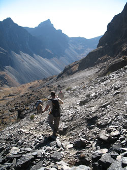
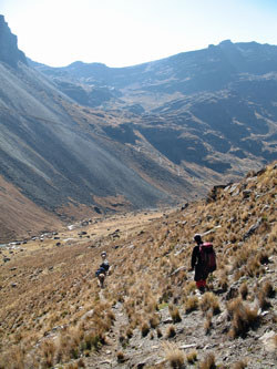
The path left town, and headed up a tight valley, descending steeply and then briefly cutting back to the west to cross yet another stream on a small cast concrete footbridge. The footpath then began to change direction, as in going up hill, and soon intersected a mining road that comes from the Alto Plano in the west passes through Illo before starting to climb to Sunchuli pass, many miles away. We merged onto the road to continue our trek to the south. We were not sure how far it was to Piedras but the road kept going, up here and down there, but always hugging the western side of the canyon and always leaving views of individual farmsteads dotting the base of the canyon.
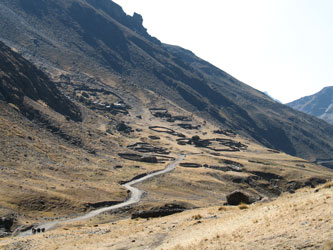
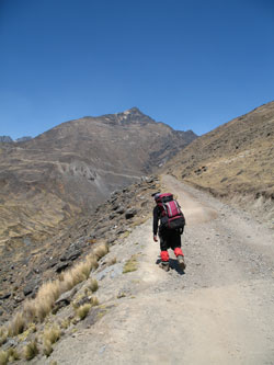 The road continued on and on, as we slowly gained altitude. We knew it went to Piedras but how far was it. We walked and walked until we saw that a road, our road?, turned to the east and cut its way to a very high pass, without any sign of a village. But to get to the steep part, we noticed that the road had to make a sharp hairpin at a junction of two valleys. There, ahead, in the valley straight ahead, stood a number of stone and thatch homes and llama corrals . . . could that be Piedras Grande? The road continued on and on, as we slowly gained altitude. We knew it went to Piedras but how far was it. We walked and walked until we saw that a road, our road?, turned to the east and cut its way to a very high pass, without any sign of a village. But to get to the steep part, we noticed that the road had to make a sharp hairpin at a junction of two valleys. There, ahead, in the valley straight ahead, stood a number of stone and thatch homes and llama corrals . . . could that be Piedras Grande?
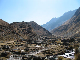
We arrived at the village, actually not so much a village but just a concentration of homes spread among the flats adjoining the road. That was it, Piedras Grande and supposedly where we would spend the night. But, such was not the case as the Piedras Grande camp site was still bit further on. Just before that point, we stopped to rest and I managed to sit on what appeared to be mossy surface. If you have read my comments on sleeping bag pads in the Logistics section, you can guess how soft that moss was. It isn't, it is actually a pin cushion waiting to puncture the backside on anyone dumb enough to sit on it. Try yourself, just sit for but a second, you'll be right up real soon. Then you will ge to pick 200 spines out of your backside,lots of fun . . .
 The Piedras Grande camp is about a mile past Piedras proper and it located at a point where a creek comes down and crossed the road. The campsite proper is not along the road but is down on a flat about 200 feet below the road. The ground is flat but like I said earlier, bring the extra pads because there is no shortage of thorns waiting for you inflatable mattress if you carry one. We set our tent, just one this time, in the one thorn free spot and padded the inflatables with the empty duffels and other spare gear. We gave Mario a hand with the pyramid tent and before long camp was set. The Piedras Grande camp is about a mile past Piedras proper and it located at a point where a creek comes down and crossed the road. The campsite proper is not along the road but is down on a flat about 200 feet below the road. The ground is flat but like I said earlier, bring the extra pads because there is no shortage of thorns waiting for you inflatable mattress if you carry one. We set our tent, just one this time, in the one thorn free spot and padded the inflatables with the empty duffels and other spare gear. We gave Mario a hand with the pyramid tent and before long camp was set.
We shared this camp site with a Swiss couple who had all the social appeal of a plugged up toilet. Though they were second to the camp, I suppose they felt that we were invading their private reserve. We made an effort to talk but they left no doubt that there was little interest in chatting about the routes were had covered, since we were going in opposite directions. Mario cooked a nice dinner and pretty soon we made our way to the tent. The clouds came racing up the valley perhaps an hour before sunset and made for a cold and damp evening, but by midnight, the clouds had retraced their path back to the far distant lowlands, leaving little more than a cold starry night between us and our next day's travel.
|
