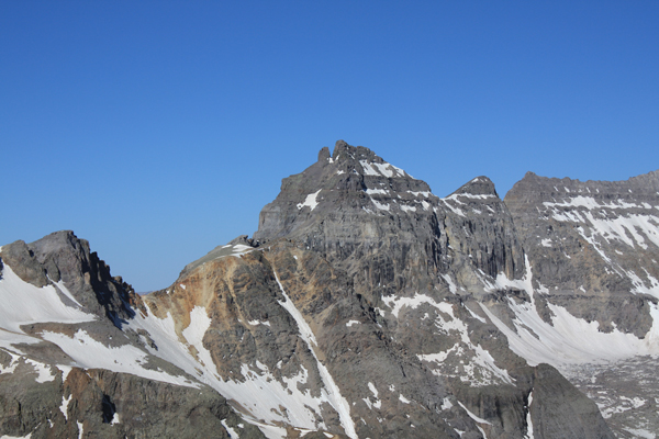
Dallas Peak
June 16, 2012 - East Face Classic - Summit
Six weeks earlier, Ed and I made a sporting attempt to climb Dallas Peak but were turned back by snow at the summit climb. I did not have a repeat climb planned but instead proposed a climb of Rio Grande Pyramid to G, Bob, and Cali. However, Bob wanted exposure, he wanted challenge, and he had never been to the San Juans climbing. G suggested that if I thought the snow had melted enough at the summit block, that we should take a run at Dallas. I hazarded a guess that the snow was now much less of an issue . . . so we were off to give the "hardest" of the Centennials a shot.
 We left Cheyenne on Friday and drove through to Telluride and set up camp at the gate to the water treatment plant. Dinner in town followed and by 10 p.m. we were in the tents, "looking forward" to the alarm going off at 2:30 for a 3 a.m. start. Right at 2:30 sharp, Donna Summer's Last Dance alarm tone came forth from my iPhone and we were in gear. I knew that the approach would be long but that this time there would be no snow at least until we had cut off the trail at the grassy hill and climbed at least part of the way up to the first cliff band. There was no snow en route and just after dawn, we arrived at the grassy hillside where I announced that the climb would begin in earnest. We left Cheyenne on Friday and drove through to Telluride and set up camp at the gate to the water treatment plant. Dinner in town followed and by 10 p.m. we were in the tents, "looking forward" to the alarm going off at 2:30 for a 3 a.m. start. Right at 2:30 sharp, Donna Summer's Last Dance alarm tone came forth from my iPhone and we were in gear. I knew that the approach would be long but that this time there would be no snow at least until we had cut off the trail at the grassy hill and climbed at least part of the way up to the first cliff band. There was no snow en route and just after dawn, we arrived at the grassy hillside where I announced that the climb would begin in earnest.
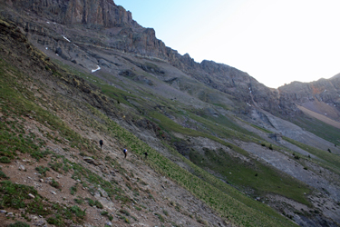
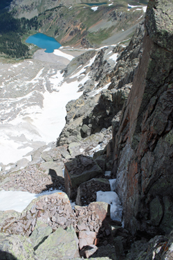
 Once up the grassy slope, we saw that the entire route up to the cliff ban was bone dry and then that the traverse below the cliffs was also dry. Where we had cramponed up hard snow just 6 weeks before, we now slogged up the scree and low angled rock, a surface much less friendly to the ascent. The traverse below the cliffs was a precursor of things to come as the smoothing nature of the snow was gone and in its place, the cliff band traverse was more bumpy and slightly unfamiliar toward the end. We cut the intermediate ridge and landed on the face below the climb to the summit proper and all familiarity was gone. The snow had covered the minute ups and downs and had given a clear course to traverse. The snow was now unfortunately a thing of the past. Once up the grassy slope, we saw that the entire route up to the cliff ban was bone dry and then that the traverse below the cliffs was also dry. Where we had cramponed up hard snow just 6 weeks before, we now slogged up the scree and low angled rock, a surface much less friendly to the ascent. The traverse below the cliffs was a precursor of things to come as the smoothing nature of the snow was gone and in its place, the cliff band traverse was more bumpy and slightly unfamiliar toward the end. We cut the intermediate ridge and landed on the face below the climb to the summit proper and all familiarity was gone. The snow had covered the minute ups and downs and had given a clear course to traverse. The snow was now unfortunately a thing of the past.
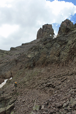
 Now . . . there were little climbs up and down and where I expected to be in familiar territory, much was just plain foreign. I knew where we needed to get to before climbing up but my world was now one of confused rock rather than inviting snow. We cut far enough east to start climbing upward and step by step and we slogged upward stopping here and there to assess our gain and question whether we were in the correct gully. The gully side class 4 climb that Ed and I did to avoid an icy overhang was gone and . . . now replaced by a two steps up and one step backward slog. Finally we cut the ridge top at about 13,250 and took a break before heading the the summit block area. Now . . . there were little climbs up and down and where I expected to be in familiar territory, much was just plain foreign. I knew where we needed to get to before climbing up but my world was now one of confused rock rather than inviting snow. We cut far enough east to start climbing upward and step by step and we slogged upward stopping here and there to assess our gain and question whether we were in the correct gully. The gully side class 4 climb that Ed and I did to avoid an icy overhang was gone and . . . now replaced by a two steps up and one step backward slog. Finally we cut the ridge top at about 13,250 and took a break before heading the the summit block area.
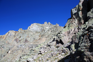
 The route up to the base of the summit pillars was a lesser angled course along a climber's trail through scree before a slightly steeper climb through rotten talus to the block. We saw that the chock stone crack was still full of snow at the top, hence no hole below the chock stone to later rappel through. We moved to the slot to the right and started climbing up to gain the area just shy of the ledge move to the summit pitch. Cali and Bob climbed without problem, I stalled out and the others broke out the rope and dropped a tail down to offer me and G a Batman style hand hold climb. Soon enough all of us were at the top of the slot and I was off to investigate the "ledge" that was unable to find six weeks before. The route up to the base of the summit pillars was a lesser angled course along a climber's trail through scree before a slightly steeper climb through rotten talus to the block. We saw that the chock stone crack was still full of snow at the top, hence no hole below the chock stone to later rappel through. We moved to the slot to the right and started climbing up to gain the area just shy of the ledge move to the summit pitch. Cali and Bob climbed without problem, I stalled out and the others broke out the rope and dropped a tail down to offer me and G a Batman style hand hold climb. Soon enough all of us were at the top of the slot and I was off to investigate the "ledge" that was unable to find six weeks before.
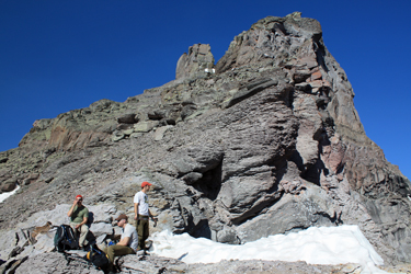
 This time the ledge was more clear as it was not covered with a bank of snow angled to the outer edge of the traverse. I carefully traversed the ledge and scoped out the base of the summit climb. G followed after a bit and we looked at both the route and the building clouds above. It was now 11 a.m. and we had been going for a solid 8 hours to just get to this point. I was pretty tired but thought I could make the climb. I have no doubt G too could have made the climb but given that the route required one to negotiate 5.3 and a 5.1 sections to summit and that we had 4 climbers, only two of whom had any lead or belaying experience, we recognized that time was not on our side. We discussed our options and G advised that he would take Cali down and I agreed to take a shot at the summit with Bob. This time the ledge was more clear as it was not covered with a bank of snow angled to the outer edge of the traverse. I carefully traversed the ledge and scoped out the base of the summit climb. G followed after a bit and we looked at both the route and the building clouds above. It was now 11 a.m. and we had been going for a solid 8 hours to just get to this point. I was pretty tired but thought I could make the climb. I have no doubt G too could have made the climb but given that the route required one to negotiate 5.3 and a 5.1 sections to summit and that we had 4 climbers, only two of whom had any lead or belaying experience, we recognized that time was not on our side. We discussed our options and G advised that he would take Cali down and I agreed to take a shot at the summit with Bob.
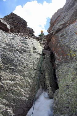 I am not a rock climber, or at least I spend no time going out to climb rock. When faced with a 5.3 pitch in hiking boots, I really struggle and that was the case here for sure. We set up a belay and Bob covered the bottom end while I took the pointy part. The first 20 feet of the climb was clad in snow . . . not the good snow you climb with ease, but three plus feet of facets. I could gain nothing in the snow . . . just nothing. Even the most slow and careful step constructing footfall turned to nothing. I finally traversed right and got up onto a muddy ledge and placed my first piece of pro. When secured to that point, I began a successful traverse across the face of the large rock that forms the center of the pitch and found a perfect pro placement six feet further on. Hand and foot and an umph of effort got me to the top of the 5.3 pitch and gave me another piece of pro. I am not a rock climber, or at least I spend no time going out to climb rock. When faced with a 5.3 pitch in hiking boots, I really struggle and that was the case here for sure. We set up a belay and Bob covered the bottom end while I took the pointy part. The first 20 feet of the climb was clad in snow . . . not the good snow you climb with ease, but three plus feet of facets. I could gain nothing in the snow . . . just nothing. Even the most slow and careful step constructing footfall turned to nothing. I finally traversed right and got up onto a muddy ledge and placed my first piece of pro. When secured to that point, I began a successful traverse across the face of the large rock that forms the center of the pitch and found a perfect pro placement six feet further on. Hand and foot and an umph of effort got me to the top of the 5.3 pitch and gave me another piece of pro.
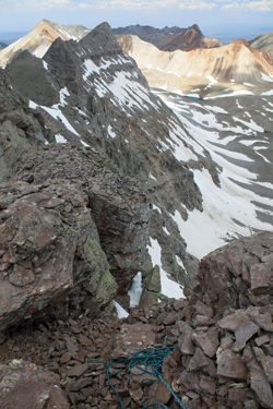 I took the next group of class 4 moves with relative ease and then found the 5.1 pitch that I was able to get up and put in another two pieces of pro. These combined efforts gave me about 70 of the 90 feet in the bag at which time I constructed an anchor and brought Bob up to me. Bob climbed, making much better time than I had experienced, before I directed him to climb the last class 3 pitch to the summit, set up a hasty sitting belay and bring me on up. With over an hour of effort, we scored the summit of Dallas Peak. The cloudscleared during our climb and though there was no present danger of a storm, we were already 9 hours into a day that we hoped would not be more than a 10 or 11 hour experience. I took the next group of class 4 moves with relative ease and then found the 5.1 pitch that I was able to get up and put in another two pieces of pro. These combined efforts gave me about 70 of the 90 feet in the bag at which time I constructed an anchor and brought Bob up to me. Bob climbed, making much better time than I had experienced, before I directed him to climb the last class 3 pitch to the summit, set up a hasty sitting belay and bring me on up. With over an hour of effort, we scored the summit of Dallas Peak. The cloudscleared during our climb and though there was no present danger of a storm, we were already 9 hours into a day that we hoped would not be more than a 10 or 11 hour experience.
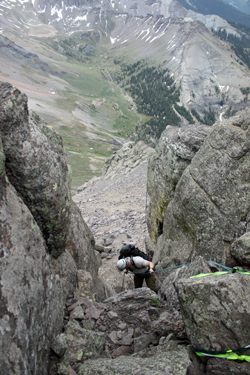
We did not monkey around with any summit sojourns . . . we took summit photos and rigged the rappel to make our way down past the chock stone and on down the mountain. The anchor rock had a collection of slings so I added mine to the crowd . . .I simply had not know the history of the slings so I left what was there in place and used them as a back-up. I figured that some local 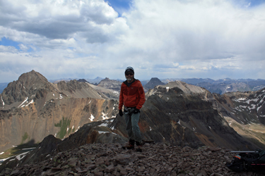 would take offense to the number of slings and clear them all out, after which the sling population would again build until the next clean out effort. I gave Bob the choice to go first or second as he has much less rappelling experience than I have from years of caving. The choice was simple, if one goes first . . . there is no belay, if one goes second . . . there is no second set of eyes on your rig. Bob chose to go first and he did a fine job negotiating his first free rappel. I promptly followed and pulled the rope from below the chock stone. would take offense to the number of slings and clear them all out, after which the sling population would again build until the next clean out effort. I gave Bob the choice to go first or second as he has much less rappelling experience than I have from years of caving. The choice was simple, if one goes first . . . there is no belay, if one goes second . . . there is no second set of eyes on your rig. Bob chose to go first and he did a fine job negotiating his first free rappel. I promptly followed and pulled the rope from below the chock stone.
 With the gear packed away, we set off for the truck. Our first error was to not move quite far enough east on the descent so that we got pulled into a sucker draw. That route cliffed out and gave us the opportunity to back track . . . up through scree . . . to get to the top of the correct descent gully. Next we cut west too soon and ended up at the edge of the cliff band but a good 200 feet too high . . . not good. We wended our way down to the right breakpoint on the fin preceding the cliff band traverse and then made steady time along the cliff and then on back down to the Sneffels High Line Trail. From there is was just a hike out, but those three miles still took a bit more out of us before we returned to the truck. Our total time was 15 1/2 hours, a good bit more than we expected. G and Cali got back about 2 hours before we did, having taken the opportunity to check out the waterfall that one sees from the top of Dallas and to our mutual and great appreciation, they broke camp and were ready to roll to Ouray for our climb of the Southwest Ridge of Mt. Sneffels. With the gear packed away, we set off for the truck. Our first error was to not move quite far enough east on the descent so that we got pulled into a sucker draw. That route cliffed out and gave us the opportunity to back track . . . up through scree . . . to get to the top of the correct descent gully. Next we cut west too soon and ended up at the edge of the cliff band but a good 200 feet too high . . . not good. We wended our way down to the right breakpoint on the fin preceding the cliff band traverse and then made steady time along the cliff and then on back down to the Sneffels High Line Trail. From there is was just a hike out, but those three miles still took a bit more out of us before we returned to the truck. Our total time was 15 1/2 hours, a good bit more than we expected. G and Cali got back about 2 hours before we did, having taken the opportunity to check out the waterfall that one sees from the top of Dallas and to our mutual and great appreciation, they broke camp and were ready to roll to Ouray for our climb of the Southwest Ridge of Mt. Sneffels.
|
