|
||
|---|---|---|
Introduction & OverviewJune 13 - 23, 2008
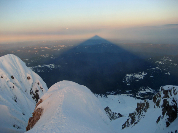
We've climbed outside of the U.S. for two weeks every summer since 2001 and after last year's Bolivia trip, we were ready for a no sickness - low stress trip to somewhere in the U.S. G had climbed Mt. Rainier many years before with Rainier Mountaineering and wanted to do the peak again, this time without a guide. He'd also been up Mt. Hood and was willing to climb it again so that Ed and and I could claim the peak and the Oregon highpoint. Rather than take the more popular late summer climbing window, we elected to go in mid June, taking our chances with snowy approaches and hoping for less crowded conditions on these very popular climbs. Routes:For Mt. Rainier we chose the Emmons Glacier Route. We knew that the route would be less crowded than the stanard Disappointment Cleaver route, with its constant flow of guided groups, and that the Emmons route would allow an equally good introduction to Mt. Rainier. A high camp would be required at Camp Shurman but with 10,000 feet of vertical gain, a high camp on a glacier was inevitable. The Emmons route provided a climb of three days duration. For Mt. Hood we did not know what route we would climb until we stood in the parking lot on the afternoon before the climb. We selected the West Crater route but then the next morning we opted to stay on the beaten track and do the Hogsback with the Old Crater variation that is now the norm. The route change was a function of the warm and clear weather and its sure promise of softening snow under clear skies along with the admonition of a local to beware of the avalanche potential. Our climb from the parking lot (real climbers eschew the Sno-Cat) took 9 1/2 hours total. Getting there and back:We flew from Denver to Seattle Tacoma Airport via Alaska Airlines, whose service was fine and a vast improvment over the debacle we experienced with American last year on our way to Bolivia. I had not flown on Alaska since a pre pipeline flight to Fairbanks many many years ago. We selected SeaTac over Portland as Rainier was our primary climbing goal and we figured that if the weather went bad on us, we would kill time in and around Seattle until a climbing opportunity presented itself. Fortunately, we did not wait long as we hit a window of 9 clear days in a row, after what the locals described as a five week spell of more or less continuous bad weather. A bit of tourism on the front and back:
Following the Hood climb, we wanted to take a few days of rest before either taking on another peak or doing something else to fill out the remaining three days of the trip. Ed had not been to Mt. St. Helens so we decided to
Gear and the stove hassle:
We also stopped in at a few other outdoor retailers, including Feathered Friends and Outdoor Research, to pick up two fuel bottles and some clothing items not readily available on the Front Range. From there it was onto Rainier. Getting around:We rented a Hyundai "Santa Fe' from Thrifty at the airport and it was the perfect size for three guys not travelling too heavy and trying to keep the rental vehicle budget under control. Cars are cheap to rent but we wanted an SUV to ensure that we could double the amount we spent on $4.30/gallon gas over the course of the trip. Seriously, we wanted to make sure we had the option to take some less travelled track if we came across the perfect beta on an out of the way climb. Anyway, we split the SUV three ways so it crept into the affordable or, more properly, "I'm willing to pay that much" range. Permits:We acquired our reservation to camp at Camp Sherman about 8 weeks before the trip and, due to being early in the climbing season, there were still spots open when we checked in at the ranger station before our climb. The permit acquisition process was painless . . . print the form from the park's web site, fill it out, and fax it to the climbing office. I checked my American Express account three days later and there was a charge for the climbing permit and the camp site. The confirmation came in the mail a few days later and we knew the trip was on. Maps and Route Information:We started the trip with the requisite topo of Rainier and Hood and picked up a second map of Rainier that had the route we planned to climb marked on it. Of course, the marked route is subject to the whims of the glacier and really only ended up providing an overview as we later found ourselves winding our way around crevasses and across snow bridges. Other than that, the old standby, a Rand McNalley Washington State road map, was sufficient for this trip. I also printed out an assortment of route descriptions for Mt. Hood from the Summitpost website and read a number of trip reports for the Emmons Glacier route we planned to take on Rainier. This information provided some familiarity and general descriptions but of course when you leave the trailhead the hearsay beta quickly falls to the wayside as you climb.
|

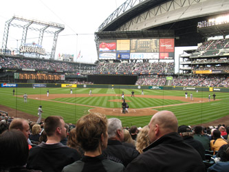 We elected not to slum it on arrival so we spent our first night at the downtown Seattle Sheraton, which is very centrally located. We took in the Pike Place Market and did the tourist thing of watching the salmon get tossed through the air. The Seattle Mariners were playing at home and we went to the park to watch the home team lose to the Washington Nationals. It was good to start the trip with a day to rest up a bit, see some of the sights and then move on toward the first climb.
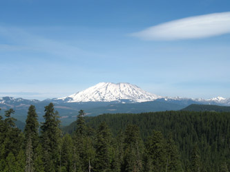 take a drive to Windy Ridge in the "flattened" area of the volcano monument, but we were early and the road had not been plowed out for the summer season. We visited Washington State's Mt. St. Helens visitor center, outside of Kelso, and then made a run for the Olympic Peninsula. None of us had been to the
 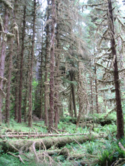 The next day we checked out the big trees and thick growth at the Hoh Rainforest Visitor Center, soaked in the hot pools at Sol Duc and then made our way to Whidbey Island for the night. We played around with the idea of a climb of Mt. Olympus but the approach distance did not put that peak in our schedule and the snow line would have offered a marathon route finding effort. Our last day was spent on a whale watching cruise where we were fortunate enough to see a large group of orcas before heading for the airport and the flight home. No third peak but the trees, coast, a hot soak, and the whales brought the trip to successful conclusion.
 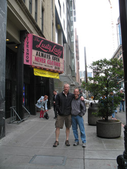 We planned to rent a stove for high camp "gourmet meals" and melting snow for three people (try flying anywhere with a camp stove these days) at the Seattle REI and after some initial consternation, we bought an MSR Simmer-light for use during the trip. It was a choice of buy the MSR or rent a butane cannister stove and lug enough cannisters, at $4 each, to fill a whole pack. I've never used the cannister stoves but at least one honest REI associate advised that the gas stoves would suck at 10,000 feet and that REI did not rent stoves suitable for melting snow at a high camp on the mountain . . . we bought instead of renting. The economics were the same, $100 for butane and cans or a white gas guarantee that we were all three familiar with. We also stocked up on Gu, Cliff bars, and another map of the more popular routes on Rainier.