-
Mt. Bierstadt Group Summit - Front Range, Colorado
-
A rest before the summit push on Dallas Peak - San Juan Range, Colorado
-
Broken Ankle + 6 Miles = Tired
-
The classic San Juan approach - San Juan Range, Colorado
-
Overlooking Noname Basin from Twin Thumbs Pass - San Juan Range, Colorado
-
Upper Noname Basin - San Juan Range, Colorado
-
Nearing Noname Cabin - San Juan Range, Colorado
-
Twin Thumbs Twins - San Juan Range, Colorado
-
Nearing the summit of Pt. 13,736 - Sawatch Range, Colorado
-
Blustery day on Iowa Peak - Sawatch Range, Colorado
-
Morning snow at 15k, Cerro Ramada - Cordillera Ramada
-
Artesonraju from the summit of Nevado Pisco - Cordillera Blanca, Peru
-
February crowds on Gray's Peak - Front Range, Colorado
-
Kicking steps on Cerro Lliani - Cordillera Vilcanota, Peru
-
Final traverse to the summit of Wheeler Mountain - Ten Mile Range, Colorado
-
The long walk to Pachanta - Cordillera Vilcanota, Peru
- banner31
Afternoon at 17k on Cerro Ramada - Cordillera Ramada, Argentina
- banner22
The final ridge on Iowa Peak - Sawatch Range, Colorado
-
Summer summit on Longs Peak - Front Range, Colorado
-
A rest day at the Pachanta Hot Springs - Cordillera Vilcanota, Peru
-
Mind over matter on Mt. Parnassas - Front Range, Colorado
-
Rest stop on Cerro Lliani - Cordillera Vilcanota, Peru
- banner30
Post nap surprise on Cerro Ramada - Cordiller Ramada, Argentina
-
Summit on Cerro Lliani - Cordillera Vilcanota, Peru
- banner23
Ridge walking on Grizzly Peak - Sawatch Range, Colorado
-
Enroute the summit via the West Ridge on Pacific Peak - Ten Mile Range, Colorado
-
Mule train bound for Chilca - Cordillera Vilcanota, Peru
-
Taking in the view from Fletcher Peak - Ten Mile Range, Colorado
-
Hiking on Silverheels - Mosquito Range, Colorado
-
Traversing! Gladstone Peak - San Juan Range, Colorado
- banner24
The best of times at Willow Lake - Sangre de Christo Range, Colorado
- banner29
High Altitude Cerebral Edema? - Cordillera Ramada, Argentina
-
Bound for Chilca - Vilcanota Range, Peru
-
Going alpine light, Holy Cross Ridge - Sawatch Range, Colorado
-
Cumbre! Campa I - Cordillera Vilcanota, Peru
-
Roadside lunch with the best of company - Cordillera Vilcanota, Peru
- banner25
Long ridge walk to the summit of California Peak - Sangre de Christo Range, Colorado
- banner28
Crossing el Rio Colorado . . . in the afternoon - Cordillera Ramada, Argentina
- banner37
Dealing with Fall snows high on Casco Peak - Sawatch Range, Colorado
-
Moonrise over Mercedario - Cordillera Ramada, Argentina
-
Still climbing at 20,900 on Cerro Ramada - Cordiller Ramada, Argentina
-
Talus on Halo Ridge, Mt. of the Holy Cross - Sawatch Range, Colorado
- banner26
Deteriorating conditions on Mt. Arkansas - Ten Mile Range, Colorado
- banner27
After the climb - Cordillera Ramada, Argentina
- banner38
Taking in the view from the summit of Crystal Peak - Tenmile Range, Colorado
-
Topping out on Mt. Arkansas' North Couloir - Mosquito Range, Colorado
-
Glissade on Mt. Arkansas - Mosquito Range, Colorado
-
Hard snow morning on Teakettle Mountain - San Juan Range, Colorado
-
Spring snow announces the start of the climb on Dallas Peak - San Juan Range, Colorado
-
Crossing the Eolus Catwalk - San Juan Range, Colorado

 "San Luis is just an anthill", why bother to climb it other than to complete the tick list. If this thought has crossed your mind, you and I once thought of this peak in the same way. After you climb it, you may feel differently about this solitary and wonderful peak. I think back on the 14’ers I have climbed, all of them as a matter of fact, as I write this page and I still consider San Luis to have been among the very best. There is no knife edge ridge, there are no route finding challenges and there are no epic four wheel drive roads to get to the trail head, but it is a climb not to be missed.
 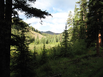 I've gotten to the Stewart Creek trail head from both Saguache and Gunnison. I'm not sure how much difference it made in either trip so long as you keep a close eye on the map for the cut off to the south, leaving Colorado 114. The guides and a map combined will get you to the trail head and there is no lack of informal camping near the parking area. The only comment I'll make on the excellent Dawson driving directions is that the turn off onto the forest service route 914 is just over the other side of the mentioned cattle guard where the road splits. You want to take the immediate right path that goes down hill and makes a sweeping turn back the better part of 150 degrees before starting back out of the drainage and onto in the direction you want to go. A second cattle guard after a half, maybe three quarters of a mile is followed by a Forest Service sign that finally identifies your route as the correct road. Later on there is another intersection where you will go straight (don't take the right turn) but that intersection has a good USFS sign pointing the right direction.
  I got there in the late afternoon, found a nice place for the night and settled down for dinner and an early start. The route is about a 12 mile round trip of gently graded trail that takes the climber up Stewart Creek, past beaver ponds and stands of aspen. I saw very little wild life but I am also a poor observer of more than my feet and the trail ahead of me if I do not stop to smell the roses. Perhaps it was a slow animal day but I cannot brag of moose or a cat, as others who are familiar with this climb have been able to relate.
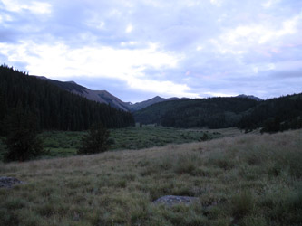
 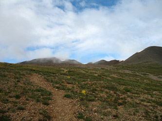 The path climbs to tree line with but a few short steep sections that remind you that this is after all a climb. The trees peter out eventually and the path wanders over a knoll and through a willowed area before the willows too give way to the altitude and the path enters short grass meadows. The route crosses the creek once, then soon another time to take to the left side of the valley where the climb portion of the ascent starts in earnest. I left the creek after pumping a full quart for the climb and made my way up the visible but again, not beaten down path, toward the saddle that is probably about six or seven hundred feet above the creek crossing.
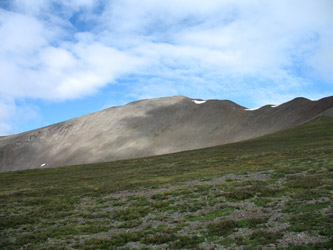 I made steady time and reached the saddle on the flank of Baldy Alto, of course thinking that Baldy might in fact be San Luis (reading a map is one thing, checking to make sure you remember to pack the map is another lesson, you think?). Such is not the case, San Luis is behind Baldy Alto and once you reach the 13,107 saddle, the trail traverses to along the flank of this lesser peak, making no false representations as to where it is going. The route and the summit of San Luis were now clearly visible. My course climbed along the rocky scree covered trail as it rose to the saddle and then continued onto the summit of San Luis.
  The rounded summit gives a good view of the San Juans and given the remote nature of the peak, I was not surprised to be alone on top. I spent some time enjoying the sun and then headed back down to the truck, logging a total climb time of just about six ½ hours. I still did not see anything more out of the ordinary than a few mule deer but there are never any guarantees in that department. I made the truck and retraced my course the Cheyenne, a long drive, but a trip well worth the effort. If you have been putting off the trip to San Luis, you are missing out. If you have already ticked San Luis off your list, then I am not telling you anything you do not already know.