Deer Mountain
North Fork Lake Creek - June 23, 2013
I was on a roll as to Sawatch Bicentennials and, with another perfect weekend forecast, a trip from Cheyenne to the Leadville area was in order. This time I picked Deer Peak as I was going to camp the night before with the Mrs. and the trailhead offered a flat spot where Chateau Xterra could be located for the night. We had dinner in Leadville at Quincy's and afterward made our way to the trail head for the evening.
 It's always fun to meet other climbers at the trail head so when a Toyota pick-up pulled in and the driver was obviously poking around for a flat spot, I knew someone else would be leaving at dark thirty the next morning. After everyone settled, I wandered over to strike up a conversation, curious as to the other person's target for the next day. It turned out the other climber was a another 14ers.com member and before and after exchanging online personas, we enjoyed talking of peaks climbed and peaks still on our respective lists. She was headed for Lackawanna in the morning while I was taking the other fork, both heading out early in the morning on an alpine start. It's always fun to meet other climbers at the trail head so when a Toyota pick-up pulled in and the driver was obviously poking around for a flat spot, I knew someone else would be leaving at dark thirty the next morning. After everyone settled, I wandered over to strike up a conversation, curious as to the other person's target for the next day. It turned out the other climber was a another 14ers.com member and before and after exchanging online personas, we enjoyed talking of peaks climbed and peaks still on our respective lists. She was headed for Lackawanna in the morning while I was taking the other fork, both heading out early in the morning on an alpine start.
 I set the alarm for 4:00 and managed to get moving seriously about 4:30. The other climber showed her mettle, getting loaded up and heading out at about the same time. she was working her Centennial list and given the hour, left no doubt she would knock one off later in the morning. We exchanged best wishes for a good day on our respective routes and I headed on up the valley. I knew there would be decent trail at least as far as the point where, last Fall, our group came down off UN13,736 after climbing Mt. Champion and running the connecting ridge. I hoped that the trail up the valley would hold out . . . it was shown as a strong trail on the T.I. map but I had also heard otherwise. I was keen to climb but really did not want a willow bushwhack if I could avoid one. I set the alarm for 4:00 and managed to get moving seriously about 4:30. The other climber showed her mettle, getting loaded up and heading out at about the same time. she was working her Centennial list and given the hour, left no doubt she would knock one off later in the morning. We exchanged best wishes for a good day on our respective routes and I headed on up the valley. I knew there would be decent trail at least as far as the point where, last Fall, our group came down off UN13,736 after climbing Mt. Champion and running the connecting ridge. I hoped that the trail up the valley would hold out . . . it was shown as a strong trail on the T.I. map but I had also heard otherwise. I was keen to climb but really did not want a willow bushwhack if I could avoid one.
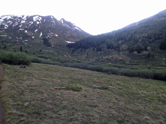
 I hiked strong trail up valley and passed the point where we had intercepted the trail the year before. I had a decent book on tape playing in the ears and the sun was not up yet, not much to see that early in the day. The sun rose as I neared the split in the valley and so I needed to keep an eye out for the stream crossing where the trail would turn for the basin below Deer Mountain. Predictably, I missed the stream crossing and found myself on a series of braided game trails so I cut to the stream to force a crossing but met with a channel wide enough that I was not going to chance it and deep enough that if I did chance and fail, I'd get soaked enough to turn the climb. My response was to head a bit further uphill where I could see the creek braided on the steeper slope and to me, braiding meant a likely crossing. I hiked strong trail up valley and passed the point where we had intercepted the trail the year before. I had a decent book on tape playing in the ears and the sun was not up yet, not much to see that early in the day. The sun rose as I neared the split in the valley and so I needed to keep an eye out for the stream crossing where the trail would turn for the basin below Deer Mountain. Predictably, I missed the stream crossing and found myself on a series of braided game trails so I cut to the stream to force a crossing but met with a channel wide enough that I was not going to chance it and deep enough that if I did chance and fail, I'd get soaked enough to turn the climb. My response was to head a bit further uphill where I could see the creek braided on the steeper slope and to me, braiding meant a likely crossing.
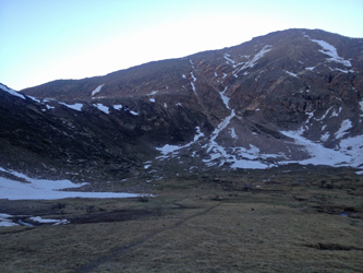
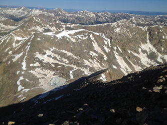
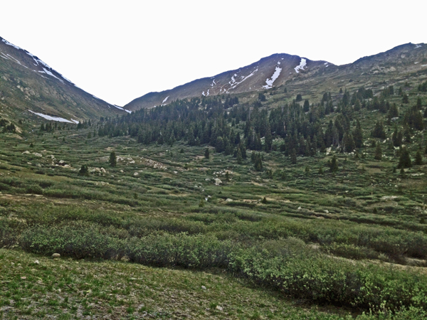
 I was across the stream in four parts, feet dry, and then within 50 yards or so, I was back on rock solid trail. The path now led up the side valley and after crossing a short descending ridge, led across the remnants of a sizeable avalanche that covered the trail to the depth of a couple of very well compacted feet. I crossed the snow and covered perhaps another quarter mile before the trail cut upward via a couple of switchbacks to a lake perched in a small hanging basin. The lake was still frozen but discretion took me around the left side and up to the saddle that separates Deer Mountain from UN13,270. Now the question was how to best surmount the steeper lower ridge that led to gentler high ground and the summit. I was across the stream in four parts, feet dry, and then within 50 yards or so, I was back on rock solid trail. The path now led up the side valley and after crossing a short descending ridge, led across the remnants of a sizeable avalanche that covered the trail to the depth of a couple of very well compacted feet. I crossed the snow and covered perhaps another quarter mile before the trail cut upward via a couple of switchbacks to a lake perched in a small hanging basin. The lake was still frozen but discretion took me around the left side and up to the saddle that separates Deer Mountain from UN13,270. Now the question was how to best surmount the steeper lower ridge that led to gentler high ground and the summit.
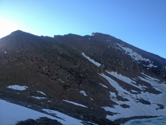
 The climbing was not hard but it was a case of picking the least difficult route through talus and later a fair portion of loose scree. I must have had the intuition of the masses as within 50 yards of making my route selection, I cut a climber's track and was on my way upward. The climb initially offered a fair portion of scree underfoot but once I broke the ridge line at the top of the steeper lower ridge, it was just a matter of talus hopping to connect strong and soft climbing trail segments. Like a couple of other peaks I've climbed recently, the surrounding peaks seemed to portend a false summit but then, suddenly, the surrounding tops are the same height and thankfully was no false summit. I reached the summit, which is a brief flat ridge with a couple of high points, but none so much different in elevation that one doesn't just take a minute to step on both "just in case . . . " The climbing was not hard but it was a case of picking the least difficult route through talus and later a fair portion of loose scree. I must have had the intuition of the masses as within 50 yards of making my route selection, I cut a climber's track and was on my way upward. The climb initially offered a fair portion of scree underfoot but once I broke the ridge line at the top of the steeper lower ridge, it was just a matter of talus hopping to connect strong and soft climbing trail segments. Like a couple of other peaks I've climbed recently, the surrounding peaks seemed to portend a false summit but then, suddenly, the surrounding tops are the same height and thankfully was no false summit. I reached the summit, which is a brief flat ridge with a couple of high points, but none so much different in elevation that one doesn't just take a minute to step on both "just in case . . . "
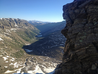
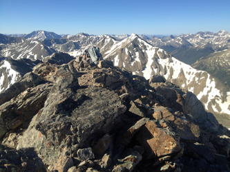 I made the summit at 8:20 and but for about 2 minutes, the whole of the climb was in the shade. I'd read that ascending this ridge in the morning would be a hike directly into the sun . . . no doubt true if you run the ridge proper. I opted for the "military crest" and stayed in the shade until the very top. I took a rest on the summit, made the standard gummi bear offering to Pachamama and then hefted the pack to head for the trail head. I dropped along the ridge, but moved a bit too low for a short stretch and then had to hold a horizontal traverse until I got back to trail segments familiar from the ascent. Though cut by a pair of steep couloirs, the majority of the face between the summit and the lake below offers nothing more than the chance to get cliffed out and backtrack uphill. I wanted no part of I made the summit at 8:20 and but for about 2 minutes, the whole of the climb was in the shade. I'd read that ascending this ridge in the morning would be a hike directly into the sun . . . no doubt true if you run the ridge proper. I opted for the "military crest" and stayed in the shade until the very top. I took a rest on the summit, made the standard gummi bear offering to Pachamama and then hefted the pack to head for the trail head. I dropped along the ridge, but moved a bit too low for a short stretch and then had to hold a horizontal traverse until I got back to trail segments familiar from the ascent. Though cut by a pair of steep couloirs, the majority of the face between the summit and the lake below offers nothing more than the chance to get cliffed out and backtrack uphill. I wanted no part of 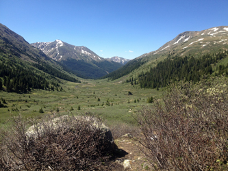 that option on a solo trip, instead being more content to repeat the ascent route, a known entity. that option on a solo trip, instead being more content to repeat the ascent route, a known entity.
Once off the ridge, it was simply a hike on back to the truck. I cut the stream at the same place and kept the feet dry, only to endure the now thawed mud that filled the trail rut for the last mile of the trip back. I got to the trail head at 11:15 or so, making for a climb that was a bit shy of seven hours but a really good day out. And, of course, congrats to the other climber on picking up Lackawanna via the back side and moving another peak closer to the top 100.
|
