Sayres Benchmark
June 3, 2012 - Northwest Flank & Ridge Fandango
After a non climbing Memorial Day Weekend, I was up for getting out. My wife had similar thoughts though she is a non climber . . . however we have fashioned a way to combine a weekend out of Cheyenne (i.e. every summer weekend if physically possible). I pick a climb where there is good camping at the trailhead and do an alpine start climb on Sunday morning. This was one of those combo trips, we play tourist on Saturday and I climb the next day.
 Bob and I climbed Grizzly Peak from McNasser Gulch the year before and I noted that for all the traffic at the LaPlata trail head, there seemed to be little interest by the crowd to make their way a couple miles up the gulch to camp. I'd grown tired of camping in what I perceive to be Asshole Alley, i.e. the road that gives access to the trail heads for Mt. Massive and the north side of Mt. Elbert. To many parties, too many shit heads bringing their tunes for all within a half mile to enjoy and two separate target practice sessions integrated with drunken revelry carried on by folks, all with our campsite with the effective range of their 9mm rounds. I'd pretty much had enough and wanted to find some climbing and camping a bit removed from that area. Bob and I climbed Grizzly Peak from McNasser Gulch the year before and I noted that for all the traffic at the LaPlata trail head, there seemed to be little interest by the crowd to make their way a couple miles up the gulch to camp. I'd grown tired of camping in what I perceive to be Asshole Alley, i.e. the road that gives access to the trail heads for Mt. Massive and the north side of Mt. Elbert. To many parties, too many shit heads bringing their tunes for all within a half mile to enjoy and two separate target practice sessions integrated with drunken revelry carried on by folks, all with our campsite with the effective range of their 9mm rounds. I'd pretty much had enough and wanted to find some climbing and camping a bit removed from that area.
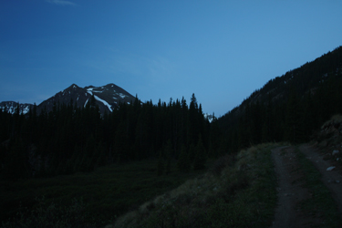
 We found a nice spot within 5 minutes walk of the trailhead for the route that leads up Sayers Gulch. We pitched camp after a decent meal at Quincy's in Leadville and called it a night at 9:30 or so. The alarm went off at 4:45 am and I was outbound at exactly 5 am. It took me exactly 5 minutes to make the first and, in hindsight, best screw up of the day. I missed the cutoff to the old mining road that lead out of Sayres Gulch for the summit. I knew from the map that an old mining road would provide the easiest access to the flank of the peak but that the switchbacks were purported to be many. However, after walking a mile and not encountering a single switchback, it was time to stop and figure out what I had done wrong. We found a nice spot within 5 minutes walk of the trailhead for the route that leads up Sayers Gulch. We pitched camp after a decent meal at Quincy's in Leadville and called it a night at 9:30 or so. The alarm went off at 4:45 am and I was outbound at exactly 5 am. It took me exactly 5 minutes to make the first and, in hindsight, best screw up of the day. I missed the cutoff to the old mining road that lead out of Sayres Gulch for the summit. I knew from the map that an old mining road would provide the easiest access to the flank of the peak but that the switchbacks were purported to be many. However, after walking a mile and not encountering a single switchback, it was time to stop and figure out what I had done wrong.
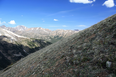
 The start of the climb was in the trees and in the dark, now I had light and I was obviously off route. The topo did not lie, I missed the cut off and could either go back a mile to find it or remedy the problem with a off trail climb of about 1000 vertical to intercept the trail high on the adjoining flank where the road should lie on the ridge line proper. I was not enthused, not at all, but I figured I would take it one step at a time and that with a 45 to 60 minute effort, I could fix the screw up. I spotted an open grassy gap in the trees on the flank and headed across the lightly willowed gulch bottom to first cross the creek. No problem and I did it feet dry. Next, it was up to the start of the climb and then on up through the grassy patch that I figured would give me open climbing for half of the required vertical. The start of the climb was in the trees and in the dark, now I had light and I was obviously off route. The topo did not lie, I missed the cut off and could either go back a mile to find it or remedy the problem with a off trail climb of about 1000 vertical to intercept the trail high on the adjoining flank where the road should lie on the ridge line proper. I was not enthused, not at all, but I figured I would take it one step at a time and that with a 45 to 60 minute effort, I could fix the screw up. I spotted an open grassy gap in the trees on the flank and headed across the lightly willowed gulch bottom to first cross the creek. No problem and I did it feet dry. Next, it was up to the start of the climb and then on up through the grassy patch that I figured would give me open climbing for half of the required vertical.
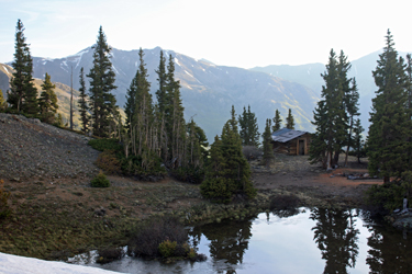
 The grassy area was fine, dry, no slips and a steep but reasonable and cliff free angle. I hit the trees and found a game trail that cut upward diagonally and took me right to another open area that would yield the ridge. The next open spot took me upward, across a ridge top depression and onto the ridge crest proper. I probably had an hour in the whole detour but I still did not have an old mine road. The map showed that that the road climbed the opposite flank of the ridge I was on and I sure was not going to descend to find it. I chose to walk the ridgeline, knowing the road would eventually come to me. I covered about 100 yards of ridge before coming out above an old but well preserved miner's cabin. Cabins and roads are like peas in a pod . . . The grassy area was fine, dry, no slips and a steep but reasonable and cliff free angle. I hit the trees and found a game trail that cut upward diagonally and took me right to another open area that would yield the ridge. The next open spot took me upward, across a ridge top depression and onto the ridge crest proper. I probably had an hour in the whole detour but I still did not have an old mine road. The map showed that that the road climbed the opposite flank of the ridge I was on and I sure was not going to descend to find it. I chose to walk the ridgeline, knowing the road would eventually come to me. I covered about 100 yards of ridge before coming out above an old but well preserved miner's cabin. Cabins and roads are like peas in a pod . . .
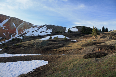
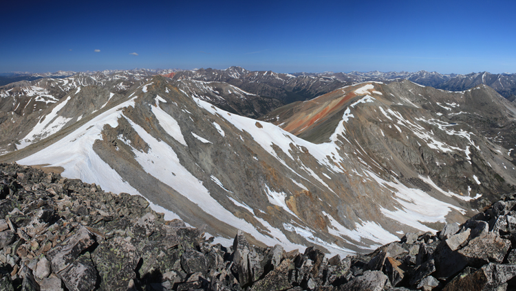
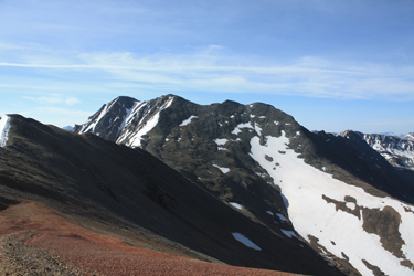 The road passed the cabin and switched back and forth a time or two before cutting the ridge top and assuming a course along the western flank of the ridge. The road offered what I hoped was an hour of easy walking on a gentle grade and I got what I was looking for. The road cut back and forth here and there but made a steady climb toward and past a number of junctions that would lead me to a mine below the saddle connecting Sayres with a another lower peak to the north. As I climbed, I kept seeing this rugged peak ahead of me but it was, in my mind, just too far off to be the summit I was after. The position of the road on the flank lead me to believe that I would come around a bend and see "my" summit off to my left, not off in the distance ahead of me. The road passed the cabin and switched back and forth a time or two before cutting the ridge top and assuming a course along the western flank of the ridge. The road offered what I hoped was an hour of easy walking on a gentle grade and I got what I was looking for. The road cut back and forth here and there but made a steady climb toward and past a number of junctions that would lead me to a mine below the saddle connecting Sayres with a another lower peak to the north. As I climbed, I kept seeing this rugged peak ahead of me but it was, in my mind, just too far off to be the summit I was after. The position of the road on the flank lead me to believe that I would come around a bend and see "my" summit off to my left, not off in the distance ahead of me.
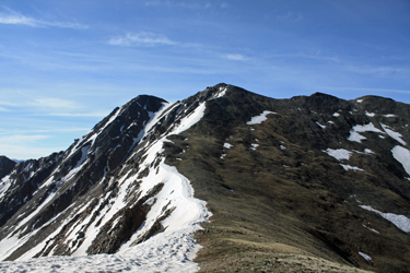 I road marched and then did it some more, eventually breaking the ridge at 13,400 and with a glance back to the north, realized that the summit about a mile distant and on the other side of a saddle rising only to 13,000 was my goal. It was one of those stop and shake the head moments. I saw that the road to the mine that I wanted had split off and descended every bit of 250 vertical, below the saddle that was 400 below me, to a disturbed area and I sure as heck was not going to backtrack or lose any elevation other than that needed to score the saddle. I shot a GU and set off along the ridge, climbing a mid point, and then dropping to the saddle to begin a climb of 700+ feet to the subsidiary summit and then over to the true high point. I road marched and then did it some more, eventually breaking the ridge at 13,400 and with a glance back to the north, realized that the summit about a mile distant and on the other side of a saddle rising only to 13,000 was my goal. It was one of those stop and shake the head moments. I saw that the road to the mine that I wanted had split off and descended every bit of 250 vertical, below the saddle that was 400 below me, to a disturbed area and I sure as heck was not going to backtrack or lose any elevation other than that needed to score the saddle. I shot a GU and set off along the ridge, climbing a mid point, and then dropping to the saddle to begin a climb of 700+ feet to the subsidiary summit and then over to the true high point.
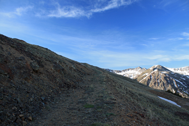
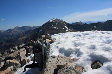
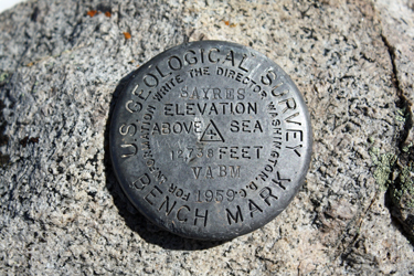
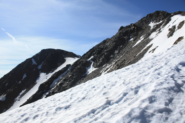 The ridge dropped me to the saddle and then I rest stepped up to the subsidiary summit, using a light climber's trail to the fore summit. Then it was no more than a quick skirt around some posthole soft snow to a short talus climb to the summit proper. A short 100 foot walk along the ridge provided what I was really after, a USGS benchmark attached to a rock bearing the name Sayres (note the elevation in the photo). The ridge dropped me to the saddle and then I rest stepped up to the subsidiary summit, using a light climber's trail to the fore summit. Then it was no more than a quick skirt around some posthole soft snow to a short talus climb to the summit proper. A short 100 foot walk along the ridge provided what I was really after, a USGS benchmark attached to a rock bearing the name Sayres (note the elevation in the photo).
I'd scored the summit after missing the proper trail at the start, making a 100 vertical climb to get back on course, and failing to realize that the road to the base of the saddle actually dropped to get to my planned climb to the saddle proper, hence climbing to 13,400 to only lose 400 feet to get to the saddle . . . not too bad after all. I did the photo thing and then set off for the campsite, about 5 miles distant.
 I elected not to go back up and over to my ridge break point but after descending 700 feet from the summit to the saddle, I continued down to the terminus of the mine road that was my original goal. I knew that the road did cut up every bit of 200 feet but I had spotted what looked like a trace of trail when looking at the route from the saddle. I figured that if I had to climb the 200+ feet to the road, I would . . . but if I found a route that would preclude a descent in lieu of a contour track, I'd take that contour route. I put out about 50 vertical feet of gain before hitting just what I hoped for . . . a very ,light trail that was stronger here and there and almost non existent in other areas that ran the 12,500 ft. contour with almost no fall whatsoever for every bit of 1/2 mile before hitting the mine road I'd climbed earlier. The trail was so faint that when I did hit the mine road, I turned around and there was no way I would have spotted it on the way up, likely even if I had been looking for it. I elected not to go back up and over to my ridge break point but after descending 700 feet from the summit to the saddle, I continued down to the terminus of the mine road that was my original goal. I knew that the road did cut up every bit of 200 feet but I had spotted what looked like a trace of trail when looking at the route from the saddle. I figured that if I had to climb the 200+ feet to the road, I would . . . but if I found a route that would preclude a descent in lieu of a contour track, I'd take that contour route. I put out about 50 vertical feet of gain before hitting just what I hoped for . . . a very ,light trail that was stronger here and there and almost non existent in other areas that ran the 12,500 ft. contour with almost no fall whatsoever for every bit of 1/2 mile before hitting the mine road I'd climbed earlier. The trail was so faint that when I did hit the mine road, I turned around and there was no way I would have spotted it on the way up, likely even if I had been looking for it.
 I hiked the road on back to the ridge break and then down to the miner's cabin where I elected to take the switch back road that I had missed in the morning. I was curious just where I'd screwed up in the morning and there was no better way to find out than track it to its juncture with the Sayres Gulch road. Back and forth that road dropped and it sees no vehicle traffic whatsoever as evidenced by three foot pines growing between the two tracks. After every bit of an hour, I crossed Sayers Creek and came to a Forest Service green bar gate, that after climbing over, left me all of 25 feet from the Sayres Gulch road. In the light of day, the gate was obvious but, earlier in the dark, I'd walked right by it without even a hint of the proper route. I hiked the road on back to the ridge break and then down to the miner's cabin where I elected to take the switch back road that I had missed in the morning. I was curious just where I'd screwed up in the morning and there was no better way to find out than track it to its juncture with the Sayres Gulch road. Back and forth that road dropped and it sees no vehicle traffic whatsoever as evidenced by three foot pines growing between the two tracks. After every bit of an hour, I crossed Sayers Creek and came to a Forest Service green bar gate, that after climbing over, left me all of 25 feet from the Sayres Gulch road. In the light of day, the gate was obvious but, earlier in the dark, I'd walked right by it without even a hint of the proper route.
 The climb took just a few minutes shy of 6 hours and in hindsight, the make due route that I used to fix the missed gate was one heck of a lot better than climbing the switch backing mine road, that would have been interminable. I'm very content that I got that 1000 feet under foot as I did in lieu of endless switchbacks. Missing the descending track to the mine pad below the saddle was also a fantastic move. My descent to that road terminus on the way out was across some horrid scree, scree that I did not have to climb up using my ridge running route. My combined map reading/route finding screw ups gave a perfect ascent route to the summit of Sayres Benchmark . . . wouldn't change a thing! The climb took just a few minutes shy of 6 hours and in hindsight, the make due route that I used to fix the missed gate was one heck of a lot better than climbing the switch backing mine road, that would have been interminable. I'm very content that I got that 1000 feet under foot as I did in lieu of endless switchbacks. Missing the descending track to the mine pad below the saddle was also a fantastic move. My descent to that road terminus on the way out was across some horrid scree, scree that I did not have to climb up using my ridge running route. My combined map reading/route finding screw ups gave a perfect ascent route to the summit of Sayres Benchmark . . . wouldn't change a thing!
|
