-
Mt. Bierstadt Group Summit - Front Range, Colorado
-
A rest before the summit push on Dallas Peak - San Juan Range, Colorado
-
Broken Ankle + 6 Miles = Tired
-
The classic San Juan approach - San Juan Range, Colorado
-
Overlooking Noname Basin from Twin Thumbs Pass - San Juan Range, Colorado
-
Upper Noname Basin - San Juan Range, Colorado
-
Nearing Noname Cabin - San Juan Range, Colorado
-
Twin Thumbs Twins - San Juan Range, Colorado
-
Nearing the summit of Pt. 13,736 - Sawatch Range, Colorado
-
Blustery day on Iowa Peak - Sawatch Range, Colorado
-
Morning snow at 15k, Cerro Ramada - Cordillera Ramada
-
Artesonraju from the summit of Nevado Pisco - Cordillera Blanca, Peru
-
February crowds on Gray's Peak - Front Range, Colorado
-
Kicking steps on Cerro Lliani - Cordillera Vilcanota, Peru
-
Final traverse to the summit of Wheeler Mountain - Ten Mile Range, Colorado
-
The long walk to Pachanta - Cordillera Vilcanota, Peru
- banner31
Afternoon at 17k on Cerro Ramada - Cordillera Ramada, Argentina
- banner22
The final ridge on Iowa Peak - Sawatch Range, Colorado
-
Summer summit on Longs Peak - Front Range, Colorado
-
A rest day at the Pachanta Hot Springs - Cordillera Vilcanota, Peru
-
Mind over matter on Mt. Parnassas - Front Range, Colorado
-
Rest stop on Cerro Lliani - Cordillera Vilcanota, Peru
- banner30
Post nap surprise on Cerro Ramada - Cordiller Ramada, Argentina
-
Summit on Cerro Lliani - Cordillera Vilcanota, Peru
- banner23
Ridge walking on Grizzly Peak - Sawatch Range, Colorado
-
Enroute the summit via the West Ridge on Pacific Peak - Ten Mile Range, Colorado
-
Mule train bound for Chilca - Cordillera Vilcanota, Peru
-
Taking in the view from Fletcher Peak - Ten Mile Range, Colorado
-
Hiking on Silverheels - Mosquito Range, Colorado
-
Traversing! Gladstone Peak - San Juan Range, Colorado
- banner24
The best of times at Willow Lake - Sangre de Christo Range, Colorado
- banner29
High Altitude Cerebral Edema? - Cordillera Ramada, Argentina
-
Bound for Chilca - Vilcanota Range, Peru
-
Going alpine light, Holy Cross Ridge - Sawatch Range, Colorado
-
Cumbre! Campa I - Cordillera Vilcanota, Peru
-
Roadside lunch with the best of company - Cordillera Vilcanota, Peru
- banner25
Long ridge walk to the summit of California Peak - Sangre de Christo Range, Colorado
- banner28
Crossing el Rio Colorado . . . in the afternoon - Cordillera Ramada, Argentina
- banner37
Dealing with Fall snows high on Casco Peak - Sawatch Range, Colorado
-
Moonrise over Mercedario - Cordillera Ramada, Argentina
-
Still climbing at 20,900 on Cerro Ramada - Cordiller Ramada, Argentina
-
Talus on Halo Ridge, Mt. of the Holy Cross - Sawatch Range, Colorado
- banner26
Deteriorating conditions on Mt. Arkansas - Ten Mile Range, Colorado
- banner27
After the climb - Cordillera Ramada, Argentina
- banner38
Taking in the view from the summit of Crystal Peak - Tenmile Range, Colorado
-
Topping out on Mt. Arkansas' North Couloir - Mosquito Range, Colorado
-
Glissade on Mt. Arkansas - Mosquito Range, Colorado
-
Hard snow morning on Teakettle Mountain - San Juan Range, Colorado
-
Spring snow announces the start of the climb on Dallas Peak - San Juan Range, Colorado
-
Crossing the Eolus Catwalk - San Juan Range, Colorado

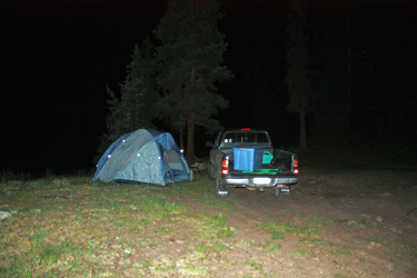 I took to the road a bit later than I'd like to have but I did manage to clear Denver and enjoy daylight all the way from Cheyenne to Monarch Pass, not a bad stretch before dark set in. I made the turn south on Colorado 114 and after 20 more miles cut off the main road onto the county and forest service roads that lead to the Stewart Creek trail head. I caught all the requisite turns and after a solid hour of dirt roads in the dark, I was not only at the Nutras Creek trail head but was presented with an optimum camp site. It was 11 p.m. so I got the tent up and hit the sleeping bag with the alarm set for 5:30 the next morning.
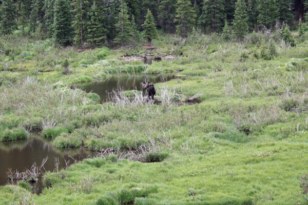
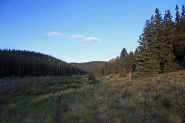 The alarm went off too "early" (on time) and I was up and moving smartly up the Nutras Creek trail by 6 a.m. The trail runs the left side of the creek drainage, which at the start is wide and has many beaver ponds. Those who have done San Luis Peak from Stewart Creek would recognize the terrain and like Stewart Creek, I was looking for moose but seeing none. Regardless, the trail starts as the remains of a jeep road but the right hand track is pretty much gone at this point. An experienced hiker can see the remnant but for all it matters I was looking at a solid single track heading up the valley.
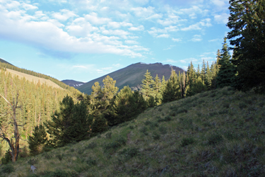 The valley narrows after a mile of so but the slope is tame, which told me that I would pay more dearly for the promised 3000 feet of elevation when the time came. After about 3 miles, a side stream entered from the right and the trail cut to the right, following the in feeder. I had a different plan, figuring to go further up Nutras Creek and then make a climb of the flank of the peak after I'd broken tree line. I crossed the side stream and looked for the trail to continue onward. I did not find a solid trail but was able to connect fairly obvious trail segments that would rise and fall on the wooded slope until I went far enough up Nutras Creek that the trees came to an end and willows filled the lower reaches of the valley.
 Oh joy . . . I love willows. I found game tracks here and there, I pushed my way through here and there, I got stuck, I got scratched, I got ticked and frustrated, but after about 15 minutes I got through, cutting a 45 degree angle from the creek to break out of the willows at the last of some higher trees. Now I had only to take on the mountain's flank to gain the ridge . . . I continued on a route that passed through a last stand of trees here and there as I diagonaled up the flank in order to break the ridge about a half mile short of the summit.
 Once on the ridge, I traversed the ridge, crossing patches of grass here and there but mostly crossing class 2 talus and holding shy of the occasional snowfield that occupied the ridge proper. The summit came after a number of ridge bumps and I soon enough took in the view of the La Garitas, including San Luis Peak and Organ Mountain. It had taken me three hours to make it to the top and I was in no hurry to make it back to the truck as I still had clear skies without the threat of a late morning monsoon storm.
  I chose not to return by the same route but instead I dropped off the summit and took a hard falling diagonal to a clear alley through the willows far below. I dropped down across the flank of the peak and hit the top of the open lane, the bottom of which deposited me at Nutras Creek. I headed downstream on a clear stream side game trail, a game trail that led me right into willow hell. The inbound willow bashing was tolerable, this one was a bear. I made my way through willow gaps, trail segments, solid willow walls and across bogs that wanted to soak my still dry feet. It came to an end after about 3 years and 6 miles, OK perhaps it was only a 20 minute adventure over a few hundred yards but you get the idea . . .