|
||
|---|---|---|
Argentina 2010Logistics III - Communications, Health, Language, MappingCommunications:
Due to the fact that we were in the remote Valle de Colorado on this trip, the availability of a satellite telephone to make an occasional call home to the spouse, letting them know that we are on schedule and that all is well additionally justified the rental. We do this through a nightly rotation, using about 3 minutes per call to let the home front know our location and that all are well. The spouse who gets the call then calls the others to relay the information. Good politics . . . Personal Locator Beacon. Another communication device that we took along for the first time was a GPS equipped personal locator beacon. While I know the response that a PLB will bring Portable Radios. We also took along a pair of Motorola walkie talkies so we could leave one at our camp and take one along as we climbed on the summit day. Our camp staff had the same idea and were similarly equipped. The end result was that on summit day, our staff at the 17,000 foot camp and the base camp monitored our progress and we were all in the know as to reaching the summit, progress in each direction and our plan to break camp and move to the base camp by the end of our summit day. Health:
In addition to general meds that we may need on the trip, everyone generally had their tetanus, hepatitis, typhoid, flu, and other inoculations in order. I took the opportunity to make a quick visit to the family doctor to appraise her of the Additionally, we purchased an inexpensive ($39) pulse oximeter for this trip, more out of curiosity than anything else. Our thoughts were that we might be able to get a feel for acclimatization as we ascended and perhaps come up with some interesting "talk around the campfire" data. Language:
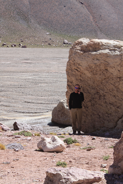
I'll throw in a plug for Ixchel Spanish School in Antigua while I'm at it. I took a two week course to improve the Spanish that I had from about four aggregate months of travel, a course or two at the community college and some opportunities to practice what I knew between trips with my Spanish speaking workforce during a thirteen month hitch with a past employer. G's Spanish comes from the Rosetta Stone course, one week in Antigua and listening to my efforts over five past trips. I give him a lot of credit, he is now putting the pieces together. Most importantly remember that a little bit of the lingo will go a long way with the locals . . . and you might even have fun in the process! Mapping:There is not a good map of the Valle de Colorado or at least one that is relatively available in the U.S. at a reasonable price. Like our trip to Bolivia's Apolobamba, we obtained GPS coordinates for the routes we were likely to climb. Those coordinates, plugged into Google Earth, yielded a functional view of the area onto which the points may be placed and labeled and distances calculated with some degree of accuracy. We produced and oblique views taken from the most likely direction of approach to give a feel for the topography. I'd sure love to have a set of USGS equivalent quads for the area but we had to make due with the resources and technology available. Curious as to the result? Well . . . this is our take on the route up Cerro Ramada using known way points in an oblique shot:
In hindsight, the Google Earth maps were just fine for our navigation needs. We were able to compare the computer generated views to the actual topography and visualize the routes and location of know way points. Interestingly, once the trip was over and the actual topography set in the mind's eye, the Google earth views were impressively accurate although some of the substantive features that we saw in the field were not readily perceived from the views we had in hand. However in hindsight, a re-manipulation of the photo does in fact show some of the features that turned out to be important in the field though not apparent on our views. From a practical perspective, a view such as that shown above was printed using a photo quality setting and then laminated at a local print shop for use in the field. Each of us had a laminated view of the climb as a whole and a second view of the terrain from our higher camps to the summit. Additionally, the way points were plugged into a handheld GPS unit to provide a means of connecting the image and our location in the dark or bad weather. next page
|

 Satellite Phone. We rented a satellite phone to give us a means to contact the logistics provider, home, or anyone else in the event of a change of plans or emergency. Our past trip re-shuffling method has ranged from sending a runner to catch a collectivo ride to Huaraz and make contact with Chris Benway in Peru to the much more effective satellite phone call to the provider we used in Bolivia to confirm that we would arrive at trail's end on the agreed upon date.
 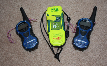 in the States, we did not know of the response a call would receive in Argentina. However, better safe than sorry and, since we have a PLB as part of the group gear already, there was no harm in taking it along.
 It never hurts to be prepared for the unexpected during the course of any climb, weekend or expedition. Given that G is a pharmacist by trade, he prepares the kit full of meds for the trip, covering everything from teeth to trots. In the past he has shut down all marine traffic on my alimentary canal, cured my Cheynes Stokes breathing at our high camps and expressed his admiration for the
 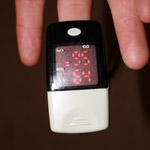 trip and finish out the final vaccinations. With a fresh visit in hand, scripts for "just in case" meds to take along were just a phone call away.
 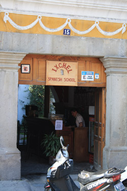 After five trips to South America to climb and other non climbing trips with my wife or another compadre, my Spanish is passable for getting around the climbing circuit. G and I both took a Spanish course in March of 2009 in Antigua, Guatemala, and that should help both of us to do a bit better talking to everyone from the taxi driver to the camp cook. Most guide books and fellow travelers say that some knowledge is better than none and our experience is that no Spanish would make for a difficult trip. Our Spanish (and Spanglish) was just fine for our needs on this trip.
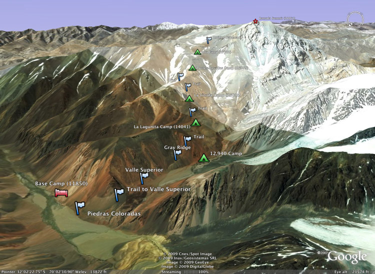