Rio Grande Pyramid
July 21, 2012 - Weminuche Pass & East Ridge Day Hike
The previous day, I hiked Phoenix Peak, a bit over 11 miles round trip and then relocated my camp to Thirty Mile Campground, located at the trail head for the Weminuche trail and the shortest route to Rio Grande Pyramid. My initial plan called for accepting a generous invite to join a group of Centennial finishers on this peak over Labor Day, but given that I am headed to the San Juans for a week between now and then and that I promised do something with my wife over the three day weekend, I opted to tag RGP while in the area.
 I covered the previous day's 11 miles without a problem and then considered whether to do RGP as an overnight or as a one day, 20 mile, hike. I had the gear for both options but given the active monsoon, I just could not get excited about camping, about lugging the extra weight, and about hoping not to get dumped on in the late afternoon or evening, so I chose the long day hike option. I usually end up doing one of these 20 mile day hikes a year and as each year goes by I wonder if this is the year it is really going to hurt. I'd done a long loop through the Chisos Rim in Big Bend back around Christmas and figured this would be about the same but for the climb coming at mid point instead of the very start. IDay hike it would be so I set the alarm for 2:00 a.m. and figured I'd be fine in the storm department so long as I was leaving the trailhead no later than 3 a.m. I covered the previous day's 11 miles without a problem and then considered whether to do RGP as an overnight or as a one day, 20 mile, hike. I had the gear for both options but given the active monsoon, I just could not get excited about camping, about lugging the extra weight, and about hoping not to get dumped on in the late afternoon or evening, so I chose the long day hike option. I usually end up doing one of these 20 mile day hikes a year and as each year goes by I wonder if this is the year it is really going to hurt. I'd done a long loop through the Chisos Rim in Big Bend back around Christmas and figured this would be about the same but for the climb coming at mid point instead of the very start. IDay hike it would be so I set the alarm for 2:00 a.m. and figured I'd be fine in the storm department so long as I was leaving the trailhead no later than 3 a.m.
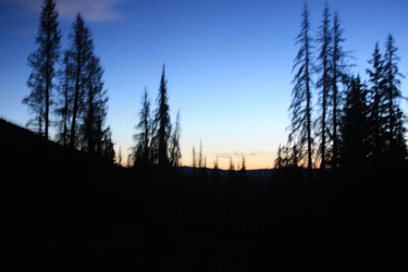
 I left the trail register right at 3 a.m. and hiked the trail along the edge of the Rio Grande Reservoir for the first mile and a half or so. There was no moon to speak of and my trusty 4 LED headlamp was down to just 2 LED's but that was enough light to do a trudge along the trail that I knew would offer no need for route finding for at least the first five miles. I made the turn away from the reservoir and after a short stretch of switch backs, I was on flatter ground and needed only put one foot in front of another for two hours or so. Slowly dawn arrived and I counted the stream crossings . . . the first one, the second one and finally the 3rd one, which marked the spot where I would cut off on the Opal Lake Trail. I left the trail register right at 3 a.m. and hiked the trail along the edge of the Rio Grande Reservoir for the first mile and a half or so. There was no moon to speak of and my trusty 4 LED headlamp was down to just 2 LED's but that was enough light to do a trudge along the trail that I knew would offer no need for route finding for at least the first five miles. I made the turn away from the reservoir and after a short stretch of switch backs, I was on flatter ground and needed only put one foot in front of another for two hours or so. Slowly dawn arrived and I counted the stream crossings . . . the first one, the second one and finally the 3rd one, which marked the spot where I would cut off on the Opal Lake Trail.
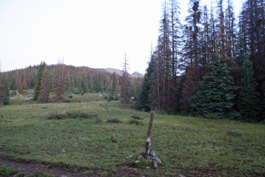
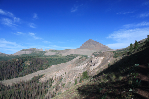
 The Roach guide noted that one passes the third creek crossing by a hundred yards or so, not so far was my experience. After a bare 50 feet I spotted the route off to the right, appearing to be the remains of an old double track. I now had five of the first ten miles under my belt and knew that I would next work my way up a ridge until I got to about the 11,500 mark, after which I would get to walk some relatively flat trail again. The ridge climb was wholly in the trees and although steep in sections was not bad at a rest step pace. I took a breather here and there and after a while came to the area of blow down that I had read of in earlier trip narratives. I'd seen some sawcut trees earlier in the hike and hoped that a trail crew had made it to this point as well. Such was not the case. The Roach guide noted that one passes the third creek crossing by a hundred yards or so, not so far was my experience. After a bare 50 feet I spotted the route off to the right, appearing to be the remains of an old double track. I now had five of the first ten miles under my belt and knew that I would next work my way up a ridge until I got to about the 11,500 mark, after which I would get to walk some relatively flat trail again. The ridge climb was wholly in the trees and although steep in sections was not bad at a rest step pace. I took a breather here and there and after a while came to the area of blow down that I had read of in earlier trip narratives. I'd seen some sawcut trees earlier in the hike and hoped that a trail crew had made it to this point as well. Such was not the case.
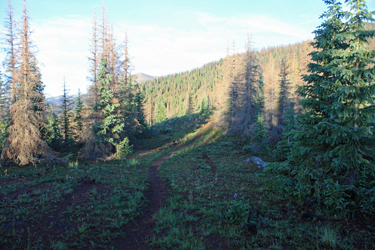
 I had read that staying high was the key but I did not realize that high meant when you get your first whiff of a downed tree, cut up one hundred vertical and thereby save a lot of grief and effort. I tried to stay high and, in my mind's eye, I could see the obscured trail below but it was all fantasy. I was lured into the depths of the blow down and as a result fought my way a good couple of hundred yards up and over until I broke out into a broad but shallow gully where I stopped to try to spot the trail below me. I was just sure it was down there but I could not even pick up a trace. I stopped in place and really gauged the landmarks as i was not looking forward to coming back to this particular point to start a reverse bushwhack on the way out, with the goal of reacquiring the not so strong tral that delviered me to the downed tree area. I had read that staying high was the key but I did not realize that high meant when you get your first whiff of a downed tree, cut up one hundred vertical and thereby save a lot of grief and effort. I tried to stay high and, in my mind's eye, I could see the obscured trail below but it was all fantasy. I was lured into the depths of the blow down and as a result fought my way a good couple of hundred yards up and over until I broke out into a broad but shallow gully where I stopped to try to spot the trail below me. I was just sure it was down there but I could not even pick up a trace. I stopped in place and really gauged the landmarks as i was not looking forward to coming back to this particular point to start a reverse bushwhack on the way out, with the goal of reacquiring the not so strong tral that delviered me to the downed tree area.
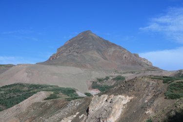 Frustrated, I climbed upward for about 200 vertical and I stepped onto a nice two foot wide, well traveled gravel trail. I'd gotten suckered. The trail took me around the point and showed me RGP and the Window. I was reinvigorated and made quick progress through the shallow upper valley, filled with willows but with a trail through the green. I passed atop a lake at a bit over 12k, the lake that I'd read of at least one other climber using as a fall camp site. I crossed the belly, getting soaked to the skin by the morning dew that still lay upon the willows, before coming around a point and traversing a contour along the base of the connecting saddle between RGP and he next summit to the east. Once blow the saddle proper, I had only to switchback a few times in order to gain the saddle and a shot at RGP. Frustrated, I climbed upward for about 200 vertical and I stepped onto a nice two foot wide, well traveled gravel trail. I'd gotten suckered. The trail took me around the point and showed me RGP and the Window. I was reinvigorated and made quick progress through the shallow upper valley, filled with willows but with a trail through the green. I passed atop a lake at a bit over 12k, the lake that I'd read of at least one other climber using as a fall camp site. I crossed the belly, getting soaked to the skin by the morning dew that still lay upon the willows, before coming around a point and traversing a contour along the base of the connecting saddle between RGP and he next summit to the east. Once blow the saddle proper, I had only to switchback a few times in order to gain the saddle and a shot at RGP.
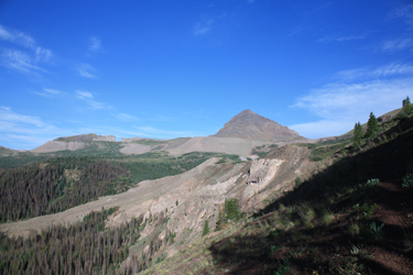
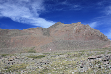 The route up the summit pyramid came in three parts, the first two of which were scree slogs up climber's use trails, just steep and loose but not hard. Those paths allowed me to tick off all but the last 600 feet, which I knew would be a talus hopping event, hopefully with a trail segment or two to cut the tedium. I connected the dots or more properly, the segments, to slowly make progress toward the summit. I continued to work my way up the east ridge, finally coming to a class three move up a short fifteen foot headwall. I was a bit tired and I knew the summit was close but in fact, I had found a false summit that would cause me to knock out another 100 feet of vertical before I achieved the summit proper. I set my pack down and took a look around at the width and breadth of the San Juan range, from the La Garitas in one direction to the Grenadiers in another. The route up the summit pyramid came in three parts, the first two of which were scree slogs up climber's use trails, just steep and loose but not hard. Those paths allowed me to tick off all but the last 600 feet, which I knew would be a talus hopping event, hopefully with a trail segment or two to cut the tedium. I connected the dots or more properly, the segments, to slowly make progress toward the summit. I continued to work my way up the east ridge, finally coming to a class three move up a short fifteen foot headwall. I was a bit tired and I knew the summit was close but in fact, I had found a false summit that would cause me to knock out another 100 feet of vertical before I achieved the summit proper. I set my pack down and took a look around at the width and breadth of the San Juan range, from the La Garitas in one direction to the Grenadiers in another.
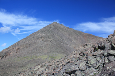 I made it to the summit at around 10 a.m., a seven hour climb over about ten miles and 4800 feet of vertical. The clouds were starting to build and I did not plan to stick around for long so I took the requisite summit photo and headed down. Curiously, I started down in the right direction but somehow slipped off to the north for a couple hundred feet before realizing my error and coming back onto course with a single traverse back onto the east ridge proper. It was one of those kind of Holy Cross moments that ends in a moment of realization and is followed by a forced course correction. Once below the summit talus and the two scree chutes, I needed only to put miles behind me to bring the hike to fruition. I was content to now find the willows dry and then I was even happier when I stuck with the trail I climb to from the windfall gully and and found myself deposited right where I first encounted the blow down . . . perfect. I made it to the summit at around 10 a.m., a seven hour climb over about ten miles and 4800 feet of vertical. The clouds were starting to build and I did not plan to stick around for long so I took the requisite summit photo and headed down. Curiously, I started down in the right direction but somehow slipped off to the north for a couple hundred feet before realizing my error and coming back onto course with a single traverse back onto the east ridge proper. It was one of those kind of Holy Cross moments that ends in a moment of realization and is followed by a forced course correction. Once below the summit talus and the two scree chutes, I needed only to put miles behind me to bring the hike to fruition. I was content to now find the willows dry and then I was even happier when I stuck with the trail I climb to from the windfall gully and and found myself deposited right where I first encounted the blow down . . . perfect.
 Thenceforth, it was a steadily slowing downhill slog as my left ACL started to tell me it was tired and I remembered that come about mile 15, this 51 year old's knees will complain a bit, not badly but they do complain. The trek down to Weminuche Pass was taken slowly but after that the easy grade down to the reservoir and on back to the campsite was pleasant enough. Overall, the distance likely came in at just about 20 miles and my time was right at 12:45. That put Centennial #95 on the list and gave me the opportunity to hike a new route in a new part of the San Juans, couldn't ask for more than that. Thenceforth, it was a steadily slowing downhill slog as my left ACL started to tell me it was tired and I remembered that come about mile 15, this 51 year old's knees will complain a bit, not badly but they do complain. The trek down to Weminuche Pass was taken slowly but after that the easy grade down to the reservoir and on back to the campsite was pleasant enough. Overall, the distance likely came in at just about 20 miles and my time was right at 12:45. That put Centennial #95 on the list and gave me the opportunity to hike a new route in a new part of the San Juans, couldn't ask for more than that.
|
