2006 Apolobamba Expedition
Climb of Nevado Cavayani
 The alarm went off at 5 a.m. and after the usual inter-tent chatter, we both got dressed and climbed out of the tents to start the day. The packs were readied the night before and now shined in the light of our headlamps with a light coating of frost, inviting both of us to saddle up and get moving. But not so fast, Mario was up and there was the promise of hot tea and coffee, brittle bread, and a bit more time before those chilly packs really had to start their trek up the valley. The alarm went off at 5 a.m. and after the usual inter-tent chatter, we both got dressed and climbed out of the tents to start the day. The packs were readied the night before and now shined in the light of our headlamps with a light coating of frost, inviting both of us to saddle up and get moving. But not so fast, Mario was up and there was the promise of hot tea and coffee, brittle bread, and a bit more time before those chilly packs really had to start their trek up the valley.
 G took off about five minutes before I did and we knew that we would meet up somewhere in the upper valley, most likely after the sun started to rise and the climb was an hour or two old. We both knew where we were going and we read routes about the same so I had little doubt that we would spot one another at the proper juncture. G took off about five minutes before I did and we knew that we would meet up somewhere in the upper valley, most likely after the sun started to rise and the climb was an hour or two old. We both knew where we were going and we read routes about the same so I had little doubt that we would spot one another at the proper juncture.
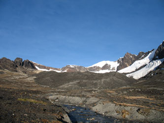
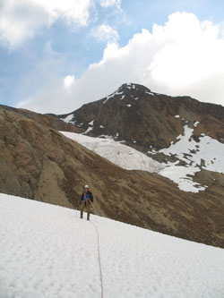
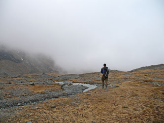
 G was having a great morning and I was not doing well. I had had a string of super days starting with the recon climb the day before our Posnansky climb and running all the way through to our arrival at the Sunchuili base camp. G had a few down days but he was good to go this morning and would undoubtably be the driving engine for the climb. My job was to drop into the mind over matter mode and just plod my way to the top of that peak so far in the distance. I walked on, crossing the dry lake bed and then considered the routes available, the northern snow spur versus the southern moraine ramp. The southern ramp was the obvious choice as it obviated the need to cross the stream issuing forth from the sizeable glacier and the risk of a climb ending prematurely due to a pair of wet feet. The moraine ramp offered the guarantee of dry feet, a longer non glacier approach and the promise of easy access to the glacier on its upper reach. G was having a great morning and I was not doing well. I had had a string of super days starting with the recon climb the day before our Posnansky climb and running all the way through to our arrival at the Sunchuili base camp. G had a few down days but he was good to go this morning and would undoubtably be the driving engine for the climb. My job was to drop into the mind over matter mode and just plod my way to the top of that peak so far in the distance. I walked on, crossing the dry lake bed and then considered the routes available, the northern snow spur versus the southern moraine ramp. The southern ramp was the obvious choice as it obviated the need to cross the stream issuing forth from the sizeable glacier and the risk of a climb ending prematurely due to a pair of wet feet. The moraine ramp offered the guarantee of dry feet, a longer non glacier approach and the promise of easy access to the glacier on its upper reach.
 The valley floor changed character markedly as we approached the terminal moraine of the glacier. The whole floor of the valley has obviously been glaciated but as long as you avoid the black and blocky active moraine, the hike remains a relatively gentle slog as you climb and skirt the toe of the glacier, alongside its southern perimeter. There is no marked trail or path so you are on your own in seeking a route that yields a steady gain in altitude while not wasting time snaking here or there around various hummocks and boulder piles. The valley floor changed character markedly as we approached the terminal moraine of the glacier. The whole floor of the valley has obviously been glaciated but as long as you avoid the black and blocky active moraine, the hike remains a relatively gentle slog as you climb and skirt the toe of the glacier, alongside its southern perimeter. There is no marked trail or path so you are on your own in seeking a route that yields a steady gain in altitude while not wasting time snaking here or there around various hummocks and boulder piles.
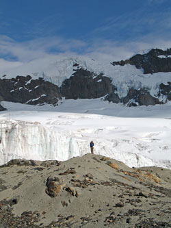
 We joined up again when we arrived near the darker active moraine and ascended past a pot hole lake to cover the last dry ground before we stopped to gear up and get onto the glacier proper. Out came the crampons, the prussik slings, the ice screws and the ice axe for the glacier travel portion of the climb. The glacier looked pretty tame and we decdied that I would take the lead, our customary climbing routine. This decision is not based upon taking turns or some other back and forth methodolgy, but by the simple matter that I weigh 40 pounds less and the odds of G stopping my fall into a crevasse are much greater than the alternative. We joined up again when we arrived near the darker active moraine and ascended past a pot hole lake to cover the last dry ground before we stopped to gear up and get onto the glacier proper. Out came the crampons, the prussik slings, the ice screws and the ice axe for the glacier travel portion of the climb. The glacier looked pretty tame and we decdied that I would take the lead, our customary climbing routine. This decision is not based upon taking turns or some other back and forth methodolgy, but by the simple matter that I weigh 40 pounds less and the odds of G stopping my fall into a crevasse are much greater than the alternative.
 The course over the glacier was straightforward as the glacier was in great shape and there were few signs of major crevasses. We skirted a pothole here and there before gaining the top of the glacier but the majority of the half mile crossing was a simple snow hike, taking the center of a few obvious snow bridges, each of which were yards wide and appeared, and turned out to be, very solid. We crossed the top of the glacier and dropped down the rear slope to land back on a talus slope forming the base of the backbone of the southern Apolobamba. The course over the glacier was straightforward as the glacier was in great shape and there were few signs of major crevasses. We skirted a pothole here and there before gaining the top of the glacier but the majority of the half mile crossing was a simple snow hike, taking the center of a few obvious snow bridges, each of which were yards wide and appeared, and turned out to be, very solid. We crossed the top of the glacier and dropped down the rear slope to land back on a talus slope forming the base of the backbone of the southern Apolobamba.
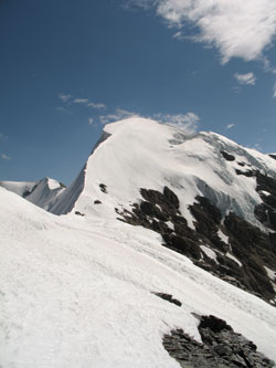
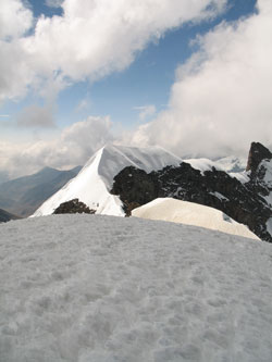
 Our view of the route from the hill just behind the camp suggeted that if we could cross the glacier we would climb up a gently sloping couloir to a saddle connecting a subpeak of the white peak and another unknwon peak to the south. We could see that the couloir was mostly rock and had a snowfield about midway up its length. Now, as we stood on the talus (read as lots of loose rocks), we were glad to see that the slope of the couloir was quite tame and that we could gain at least one third of its vertical height on snow. Our view of the route from the hill just behind the camp suggeted that if we could cross the glacier we would climb up a gently sloping couloir to a saddle connecting a subpeak of the white peak and another unknwon peak to the south. We could see that the couloir was mostly rock and had a snowfield about midway up its length. Now, as we stood on the talus (read as lots of loose rocks), we were glad to see that the slope of the couloir was quite tame and that we could gain at least one third of its vertical height on snow.
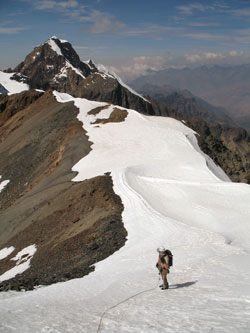
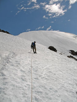
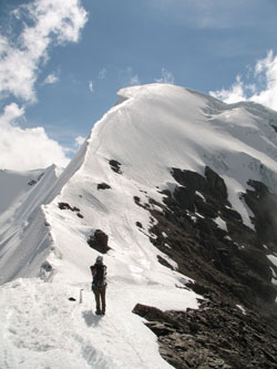
 We dropped the filter and some other weight at a water seep halfway up the slope to the saddle and continued our steady progress toward the skyline. It was typical talus climbing, loose rock under foot and plenty of opportunities to twist an ankle. The trudge continued but within 1/2 hour yielded the saddle and a view of the route up the sub peak that we would have to traverse to get up the snow covered fin further up the ridge. We stopped briefly to shoot a goo and then started moving up the ridge. The terrain was now snow agian and we let the loops of rope that we had held in our hands for the climb to the saddle fall to the snow below our feet. We dropped the filter and some other weight at a water seep halfway up the slope to the saddle and continued our steady progress toward the skyline. It was typical talus climbing, loose rock under foot and plenty of opportunities to twist an ankle. The trudge continued but within 1/2 hour yielded the saddle and a view of the route up the sub peak that we would have to traverse to get up the snow covered fin further up the ridge. We stopped briefly to shoot a goo and then started moving up the ridge. The terrain was now snow agian and we let the loops of rope that we had held in our hands for the climb to the saddle fall to the snow below our feet.
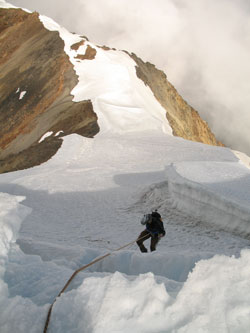
 The ridge went perhaps 50 yards before it steepened to an angle that eventually neared 70 degrees of so. I was in the lead and when I arrived at the steep section, G put in a picket and prepared to arrest a fall, should I take a mis-step. The slope was steep enough to kick straight up while stabbing an axe in a slope that touches your chest if you lean forward at the least angle. The steep section is perhaps 50 feet in height and ended at a two foot wide snow shelf below an five foot vertical face. I asked G to belay me while I whacked a break in the icy crust and then cut enough of a ramp to give one foot purchase while I pulled myself up over the lip using a well planted ice axe in the crusty layer above. The ridge went perhaps 50 yards before it steepened to an angle that eventually neared 70 degrees of so. I was in the lead and when I arrived at the steep section, G put in a picket and prepared to arrest a fall, should I take a mis-step. The slope was steep enough to kick straight up while stabbing an axe in a slope that touches your chest if you lean forward at the least angle. The steep section is perhaps 50 feet in height and ended at a two foot wide snow shelf below an five foot vertical face. I asked G to belay me while I whacked a break in the icy crust and then cut enough of a ramp to give one foot purchase while I pulled myself up over the lip using a well planted ice axe in the crusty layer above.
 I drove a snow picket down through the icy crust about six feet back from the crest and then incorporated a boot belay second to bring G up the slope and over the crest of the short vertical face. We left the picket in place as a descent anchor and gathered our gear to make the short hike to the crest of the sub-peak. The sub-peak was not our goal but we had a decision to make, to continue or call it a day here due to the time and the softening of the snow underfoot. The white peak lay before us but we found it challenging to determine its slope and as such to determine if the rest of the climb was going to be a crampon cruise that we had time for or a run of roped pitches that we could never pull off on deteriorating afternoon snow. I drove a snow picket down through the icy crust about six feet back from the crest and then incorporated a boot belay second to bring G up the slope and over the crest of the short vertical face. We left the picket in place as a descent anchor and gathered our gear to make the short hike to the crest of the sub-peak. The sub-peak was not our goal but we had a decision to make, to continue or call it a day here due to the time and the softening of the snow underfoot. The white peak lay before us but we found it challenging to determine its slope and as such to determine if the rest of the climb was going to be a crampon cruise that we had time for or a run of roped pitches that we could never pull off on deteriorating afternoon snow.
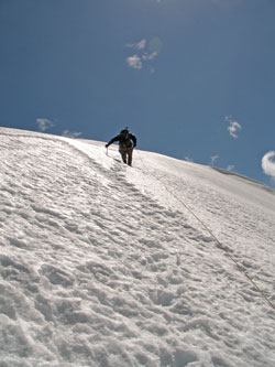
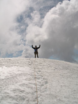
 We opted to continue, at least across the intermedaite saddle and then to the last outcrop of rock before the snow rose to the summit above. The snow conditions to the outcrop were not bad and by the time we arrived at the rock, we could see that the slope was a consistent 45 degrees to the summit. The snow was still in good shape and we decided to go for the un-named summit. G took the lead, as I was pretty beat, and set a steady pace for the top. One half hour later, we were on top, having made what in hindsight was a wonderful sinuous climb up the corniced ridge leading to the summit. We took photos, a GPS reading, and tried to note enough details to allow us to figure out the name of the peak we just climbed. We opted to continue, at least across the intermedaite saddle and then to the last outcrop of rock before the snow rose to the summit above. The snow conditions to the outcrop were not bad and by the time we arrived at the rock, we could see that the slope was a consistent 45 degrees to the summit. The snow was still in good shape and we decided to go for the un-named summit. G took the lead, as I was pretty beat, and set a steady pace for the top. One half hour later, we were on top, having made what in hindsight was a wonderful sinuous climb up the corniced ridge leading to the summit. We took photos, a GPS reading, and tried to note enough details to allow us to figure out the name of the peak we just climbed.
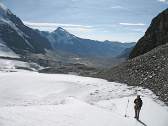
 The views, however, were fleeting as the afternoon clouds were rolling in to obscure Akamani to the south, the Sunchuli valley and even our route down the snowy fin we had jsut ascended. We were not worried about route finding but we did want to get down before the sun had the opportuntiy to soften the snow slope we needed to descend. We finished up taking pictures and started down to the sub saddle perhaps 700 vertical feet below. We crossed the sub saddle and then diverted a few yards off our approach course to step atop the actual summit of the sub-peak. That necessary task accomplished, we moved on to the snow stake we left on ascent and rappelled to the flat at the base of the seep portion of the slope. The views, however, were fleeting as the afternoon clouds were rolling in to obscure Akamani to the south, the Sunchuli valley and even our route down the snowy fin we had jsut ascended. We were not worried about route finding but we did want to get down before the sun had the opportuntiy to soften the snow slope we needed to descend. We finished up taking pictures and started down to the sub saddle perhaps 700 vertical feet below. We crossed the sub saddle and then diverted a few yards off our approach course to step atop the actual summit of the sub-peak. That necessary task accomplished, we moved on to the snow stake we left on ascent and rappelled to the flat at the base of the seep portion of the slope.
The saddle made for a good rest stop where we again shot a goo before gathering the rope into a hand coil and making our way back down the alternating route of talus and snow to the rear slope of the glacier below. We stopped at the water seep, pumped a quart of water each and then went to the base of the ice to drop the coil and replace the crampons on our boots. The course back across the galcier was worry free and within a half hour we were back at the edge of the lateral moraine and dropping our ice travel gear into our packs.
 The route from here was all dry ground and we had a GPS point marking the location of our base camp in the event we ran out of daylight, a real possibility. We started down the valley, retracing our morning course, and took a break at the mid point to shoot another goo each and empty some stones from my boot. The fog would come and go but we were getting close to camp and by the time we crossed the dry lake bed we were walking through the twighlight and mist, weaving our way through a maze of grazing cows and llamas in the rapidly dimming light. The route from here was all dry ground and we had a GPS point marking the location of our base camp in the event we ran out of daylight, a real possibility. We started down the valley, retracing our morning course, and took a break at the mid point to shoot another goo each and empty some stones from my boot. The fog would come and go but we were getting close to camp and by the time we crossed the dry lake bed we were walking through the twighlight and mist, weaving our way through a maze of grazing cows and llamas in the rapidly dimming light.
We walked into camp and found that we had company. A British trekking group was sharing our camp for the night and they had set up a half dozen tents, very close to ours. We had some dinner and nice evening conversation before taking to the tents for the night, knowing that Alcides had his heart set on an eight a.m. departure on the first of the two days it would take to trek to Charazani to meet our ride to La Paz.
|
