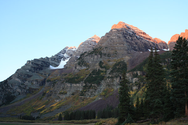
South Maroon Bell
September 19, 2009 - South Ridge
Every fall, Ed and I make plans to score another 14'er for his tally sheet. He has long since ran out of close stuff and easy walk-ups and I have long since run out of un-climbed 14'ers. Therefore, we head far from the Front Range and do a peak that I've already summitted by a different and usually easier route. In past years, we did Lindsey, but by the North Ridge, Pyramid but in the snow, and Castle via the North Face Direct in lieu of either ridge. The name of the game for 2009 was the South Bell, a peak whose summit had earlier escaped Ed by a mere 100 vertical feet. I'd already been up the South Bell, back in 2002, but I'd climbed it with G via the Bell Cord Couloir. That route was out of the running due to the season so we were off to the South Ridge. Little did I know that the South Ridge route was the slog that it is . . . a slog that I have no plans to repeat again.
 We left Cheyenne on Friday night and camped the night at the USFS Difficult Campground, just outside of Aspen on the way up Independence Pass. It was the last weekend that the campground would be open and there were plenty of spaces. Given the fall foliage, I am sure there were none to be found on the Bells Road but I was fine with getting up a half hour earlier to cover the extra distance back over the trail head. It was getting late in the season and neither of us wanted too early a start, just too much dark time in the cold. I do know the importance of the alpine start but we tempered our mountain sense and agreed to set the alarm at 5:00, figuring to hit the trail an hour later. We were climbing both Saturday and Sunday, so we had no camp to break, just bail from the tent and drive to the trail head. We hit the parking lot right at 6:00 but did not get hiking until about 6:30 or so. It was still pretty dark but there were already an ample number of photogs lining the bank of Maroon Lake, waiting for the sun to rise in the east so they too could take a photo fit for a postcard . . . or a plastic place mat. We left Cheyenne on Friday night and camped the night at the USFS Difficult Campground, just outside of Aspen on the way up Independence Pass. It was the last weekend that the campground would be open and there were plenty of spaces. Given the fall foliage, I am sure there were none to be found on the Bells Road but I was fine with getting up a half hour earlier to cover the extra distance back over the trail head. It was getting late in the season and neither of us wanted too early a start, just too much dark time in the cold. I do know the importance of the alpine start but we tempered our mountain sense and agreed to set the alarm at 5:00, figuring to hit the trail an hour later. We were climbing both Saturday and Sunday, so we had no camp to break, just bail from the tent and drive to the trail head. We hit the parking lot right at 6:00 but did not get hiking until about 6:30 or so. It was still pretty dark but there were already an ample number of photogs lining the bank of Maroon Lake, waiting for the sun to rise in the east so they too could take a photo fit for a postcard . . . or a plastic place mat.
 We covered the distance to the far end of the lake and located the cut off for the trail that rises to cross over the hump separating Maroon Lake from Crater Lake, above and the west. I always get turned around at this cut off as my virgin Elk climbs were back in the day when the trail followed the lake and then cut off to zig zag up the hump instead of taking the course of the newer approach trail. We next passed the cut off to Pyramid, by which time there was enough light to demonstrate that the colors were pretty much at their maximum and, with regard to views, we knew at first light we had picked the weekend. We covered the first mile and a half to Crater Lake quickly and kept going to cover the same distance again to arrive at the cut off to the trail leading the South Ridge. We covered the distance to the far end of the lake and located the cut off for the trail that rises to cross over the hump separating Maroon Lake from Crater Lake, above and the west. I always get turned around at this cut off as my virgin Elk climbs were back in the day when the trail followed the lake and then cut off to zig zag up the hump instead of taking the course of the newer approach trail. We next passed the cut off to Pyramid, by which time there was enough light to demonstrate that the colors were pretty much at their maximum and, with regard to views, we knew at first light we had picked the weekend. We covered the first mile and a half to Crater Lake quickly and kept going to cover the same distance again to arrive at the cut off to the trail leading the South Ridge.
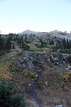
 The South Ridge cut off is as advertised, about 200 feet before the trail drops slightly and crosses the creek. The cut-off is marked by a 2 foot high cairn and an obvious course up up the nearby bank to the start of the trail that climbs endlessly upward to the South Ridge. Bear in mind, the hike to this point was a pleasure, a joy, a walk in the park. Now for Phase II, the climb from hell to the South Ridge proper. The guidebooks tell it like it is when they say that the trail climbs over 2000 feet in its next mile of length . . . and it does exactly that. The trail starts as a well worn path that skirts to the south but then it turns and starts to climb. The trail is easily followed and really is not that bad so long as you take the advice to trend to the south and stay off the scree and talus. The course is always obvious and to be honest, one can choose a path with solid footing the whole way up, and we did exactly that by staying left. The South Ridge cut off is as advertised, about 200 feet before the trail drops slightly and crosses the creek. The cut-off is marked by a 2 foot high cairn and an obvious course up up the nearby bank to the start of the trail that climbs endlessly upward to the South Ridge. Bear in mind, the hike to this point was a pleasure, a joy, a walk in the park. Now for Phase II, the climb from hell to the South Ridge proper. The guidebooks tell it like it is when they say that the trail climbs over 2000 feet in its next mile of length . . . and it does exactly that. The trail starts as a well worn path that skirts to the south but then it turns and starts to climb. The trail is easily followed and really is not that bad so long as you take the advice to trend to the south and stay off the scree and talus. The course is always obvious and to be honest, one can choose a path with solid footing the whole way up, and we did exactly that by staying left.
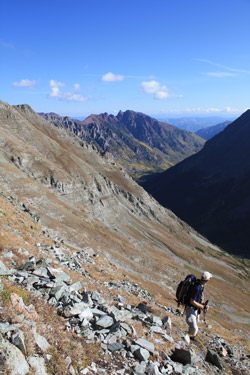
 The course covers a small amount of "shelfy" ground but really never leaves the realm of a class 1 rough trail hike with a class 2 step up here and there. We bore left and, near the top, the trail mellowed before depositing us on the ridge proper. We saw more direct alternative routes but we avoided them in favor of adding a bit of distance in our route to gain the ridge, making for a bit easier hike. Once on the proper ridge shoulder, the trail meandered upward, first on the spine proper of the wide rounded ridge and then off to the left as it climbed to intercept the Class 3 portion of the climb. We climbed steadily, switching back and forth here and there and eventually arrived at the start of the real climb. We now stopped to look at the backside of the South Bell, which is oft described, quite accurately, as a maze of shelves covered with loose rock and, on this morning, a few inches of snow from the night before. The course covers a small amount of "shelfy" ground but really never leaves the realm of a class 1 rough trail hike with a class 2 step up here and there. We bore left and, near the top, the trail mellowed before depositing us on the ridge proper. We saw more direct alternative routes but we avoided them in favor of adding a bit of distance in our route to gain the ridge, making for a bit easier hike. Once on the proper ridge shoulder, the trail meandered upward, first on the spine proper of the wide rounded ridge and then off to the left as it climbed to intercept the Class 3 portion of the climb. We climbed steadily, switching back and forth here and there and eventually arrived at the start of the real climb. We now stopped to look at the backside of the South Bell, which is oft described, quite accurately, as a maze of shelves covered with loose rock and, on this morning, a few inches of snow from the night before.
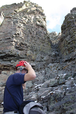
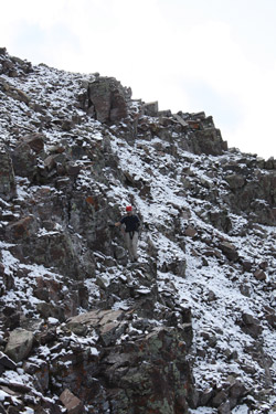 We both took a sip and Goo before striking off along the ridge proper to cover the first leg of the climb to the summit. We covered a few hundred yards of easy Class 2+/3 ridge before dropping down to traverse to a Class 3/4 slot that would deliver us to the climb proper. The helmets came out of the pack and onto the heads and we each stashed one of the two hiking poles we had in our packs. We ascended the slot and at the top chose to go right (wrong way) whereupon we climbed ten feet or so to the ridge proper and cut back left to rejoin the usual track. The route from here was obvious, partly because there were at least two groups ahead of us who had tracked the fresh snow and partly because of the cairns and gentle swale created over the years by climbers past. We both took a sip and Goo before striking off along the ridge proper to cover the first leg of the climb to the summit. We covered a few hundred yards of easy Class 2+/3 ridge before dropping down to traverse to a Class 3/4 slot that would deliver us to the climb proper. The helmets came out of the pack and onto the heads and we each stashed one of the two hiking poles we had in our packs. We ascended the slot and at the top chose to go right (wrong way) whereupon we climbed ten feet or so to the ridge proper and cut back left to rejoin the usual track. The route from here was obvious, partly because there were at least two groups ahead of us who had tracked the fresh snow and partly because of the cairns and gentle swale created over the years by climbers past.
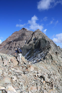
Our course traversed along the back of the Bell until we reached the second substantive climb up, a loose scree filled couloir that delivers one to an exit left cut off ledge and another set of traverses before the climb toward the summit. We missed this couloir as the trail got a bit sparse so traversed beyond where we should have cut off. No more than 200 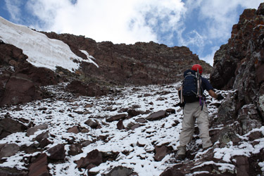 feet were needed before it was obvious we were off course due to the lack of traffic, fresh and perennial. We back-tracked and picked up the couloir that, once we were climbing, showed itself to be the obvious route. We took the requisite cut off ledge well before the ridge crest and traversed again at about the same elevation before going vertical again to climb a wider couloir with a large chunk of last winter's snow holding out for the coming cold. feet were needed before it was obvious we were off course due to the lack of traffic, fresh and perennial. We back-tracked and picked up the couloir that, once we were climbing, showed itself to be the obvious route. We took the requisite cut off ledge well before the ridge crest and traversed again at about the same elevation before going vertical again to climb a wider couloir with a large chunk of last winter's snow holding out for the coming cold.
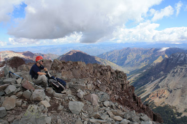
We met the other groups descending at this point and continued climbing to an obvious traverse, now perhaps only two hundred feet below the summit elevation. We traversed once again and then zigged up along the course of least resistance to the summit, arriving at a bit 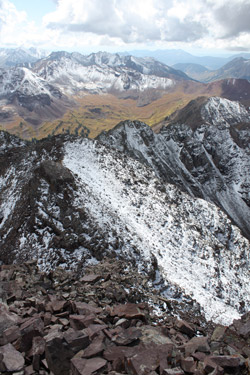 after 11:30. It was a game of climbing from ledge to ledge, a bit of loose pretty much all over and enough snow to make the route we, generally right where the next obvious hand hold was located. We soon had the summit to ourselves but we did not plan to stay long. For us, 11:30 is late, really late, and the clouds were building on all sides. It did not have the look of lightning but it did have the look of a wet walk out if we did not get a move on. We attempted to reverse our climb up but for the first two hundred feet of descent, we followed a somewhat different course than our ascent. I'm not sure it makes much difference so long as one does not drop too much before seeking to begin traversing to gain the head of the drop into the gully containing the snow remnant. after 11:30. It was a game of climbing from ledge to ledge, a bit of loose pretty much all over and enough snow to make the route we, generally right where the next obvious hand hold was located. We soon had the summit to ourselves but we did not plan to stay long. For us, 11:30 is late, really late, and the clouds were building on all sides. It did not have the look of lightning but it did have the look of a wet walk out if we did not get a move on. We attempted to reverse our climb up but for the first two hundred feet of descent, we followed a somewhat different course than our ascent. I'm not sure it makes much difference so long as one does not drop too much before seeking to begin traversing to gain the head of the drop into the gully containing the snow remnant.
We dropped down through the now muddy gully, filled with loose scree, and took the requisite cut off to the left. More traversing and after a few missed drops, we ended up having to negotiate a few down climbs to reconnect with the trail, perhaps seventy five feet below our chosen path. Not that we 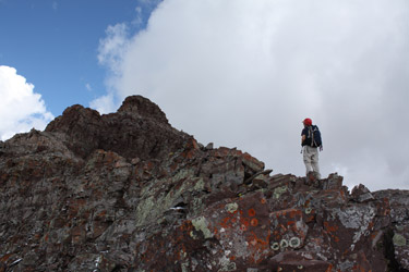 were off the cairned route, just that we were on one of the couple of cairned routes. We regained the correct trail, dropped through the second couloir and worked our way through the ledgy maze to the slot climb and back toward the start of the class 3 section on the now obvious climbers' track. The next challenge came making sure we did not drop off the ridge too soon . . . as doing so will land one on a well traveled path, a sinuous luge run through ankle wrenching talus. We dropped a bit too soon but rather than accept the fate of the talus, we cut west and contoured our way back to our ascent trail, knowing there was a relatively solid path to be had. were off the cairned route, just that we were on one of the couple of cairned routes. We regained the correct trail, dropped through the second couloir and worked our way through the ledgy maze to the slot climb and back toward the start of the class 3 section on the now obvious climbers' track. The next challenge came making sure we did not drop off the ridge too soon . . . as doing so will land one on a well traveled path, a sinuous luge run through ankle wrenching talus. We dropped a bit too soon but rather than accept the fate of the talus, we cut west and contoured our way back to our ascent trail, knowing there was a relatively solid path to be had.
 The traverse to the correct path was loose and long but eventually we scored our desired track and dropped to the point on the shoulder of the ridge where the trail is more dirt than rock and the long descent to the valley floor begins. I would guess that we took another hour to lose the better part of 1500 to 1800 feet and arrive at the trail juncture near the creek. We refilled the water bottles from the creek and were off to the truck. The hike out is every bit of 3.25 miles but it passed in no time, and why shouldn't it, we were off that hellish slope connecting the valley floor and the real climb. Our start to finish time for climb was just a few minutes under eleven hours and I came to the conclusion that given the opportunity to climb the Bell again, it would not be via the South Ridge. But let's look at the positive side, 12 miles . . 4500 vertical feet . . . a new 14'er for Ed . . . and a bit of P. T. for me. Not a bad day out in the mountains. The traverse to the correct path was loose and long but eventually we scored our desired track and dropped to the point on the shoulder of the ridge where the trail is more dirt than rock and the long descent to the valley floor begins. I would guess that we took another hour to lose the better part of 1500 to 1800 feet and arrive at the trail juncture near the creek. We refilled the water bottles from the creek and were off to the truck. The hike out is every bit of 3.25 miles but it passed in no time, and why shouldn't it, we were off that hellish slope connecting the valley floor and the real climb. Our start to finish time for climb was just a few minutes under eleven hours and I came to the conclusion that given the opportunity to climb the Bell again, it would not be via the South Ridge. But let's look at the positive side, 12 miles . . 4500 vertical feet . . . a new 14'er for Ed . . . and a bit of P. T. for me. Not a bad day out in the mountains.
Or the more direct route . . . the Bell Cord Couloir
|
