Cathedral Peak
September 20, 2009 - South Ridge
A climb of Cathedral Peak was my fee for accompanying Ed up the South Ridge of the South Bell the previous day on our annual fall 14'er climb. The leaves were right, the barbeque at the Hickory House was as good as I remembered it and I'd scored a full 8 hours sleep after the climb of the Bell. We set the alarm for 5 a.m. and just before the clock started its infernal tone, the rain began its patter on the tent fly. I was a bit tired and thought that the rain 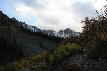 might provide the justification to skip a second day's climbing and go for a soak in the pool at Glenwood Springs. But I do think you have to at least go to the trail head and watch the rain flow down the windshield before calling it quits on a day's climbing. We broke the tent and were off to the trail head, just a bit beyond the ghost town of Ashcroft. The problem was that the rain that gave me hope of a soak, gave way to broken clouds, a few stars here and there, and the need to heft the pack and get a move on up the trail. might provide the justification to skip a second day's climbing and go for a soak in the pool at Glenwood Springs. But I do think you have to at least go to the trail head and watch the rain flow down the windshield before calling it quits on a day's climbing. We broke the tent and were off to the trail head, just a bit beyond the ghost town of Ashcroft. The problem was that the rain that gave me hope of a soak, gave way to broken clouds, a few stars here and there, and the need to heft the pack and get a move on up the trail.
The previous day's three plus mile approach to the Bell was a good walk in the park and over the years I've gotten used to the idea of a three to four mile approach as a necessary but not 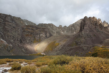 real hard evil inherent in many climbs. Roach's guide tells of the appraoch to Cathedral being a 3 plus mile trail hike with a solid 2000 feet of elevation gain. I'm an engineer so that type of description just invites me to use my extensive knowledge of less than long division to determine that 666 feet of gain per mile is . . . just nothing to get stirred up about. We packed light and soon moving along the gently climbing trail through the aspen groves. The leaves were yellow everywhere and some were starting to fall onto the trail, a sure sign of winter soon to follow. The trail wandered over into the valley where Pine Creek descends from the lake and then climbed steadily, never too close to the creek but always in sight and sound of the creek as it falls from the valley above. real hard evil inherent in many climbs. Roach's guide tells of the appraoch to Cathedral being a 3 plus mile trail hike with a solid 2000 feet of elevation gain. I'm an engineer so that type of description just invites me to use my extensive knowledge of less than long division to determine that 666 feet of gain per mile is . . . just nothing to get stirred up about. We packed light and soon moving along the gently climbing trail through the aspen groves. The leaves were yellow everywhere and some were starting to fall onto the trail, a sure sign of winter soon to follow. The trail wandered over into the valley where Pine Creek descends from the lake and then climbed steadily, never too close to the creek but always in sight and sound of the creek as it falls from the valley above.
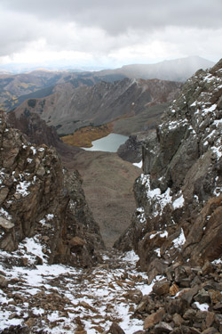
 Perhaps after a mile, the trail cut right and zigged here and there to climb the first steep section, parallel to where the creek was dropping down through a series of small cataracts. We climbed up through the mixed aspen/pine forest and came into view of the peaks that form the ramparts around Cathedra Lake. We could not see Cathedral proper but could see that we were climbing into a cirque, one side of which would include our planned summit. We continued climbing, coming to a very steep slope that causes the trail to switch back and forth across the steep ground before surmounting the slope and covering the last bit of ground to tree line. We came to a trail junction/creek crossing with a sign noting the course to Cathedral Lake and another path to Electric Pass. We were lake bound so we crossed the log bridge and hiked another quarter mile on the well traveled trail, flanked on both sides by willows. We topped a hill and there lay Cathedral Lake, no small body of water. Perhaps after a mile, the trail cut right and zigged here and there to climb the first steep section, parallel to where the creek was dropping down through a series of small cataracts. We climbed up through the mixed aspen/pine forest and came into view of the peaks that form the ramparts around Cathedra Lake. We could not see Cathedral proper but could see that we were climbing into a cirque, one side of which would include our planned summit. We continued climbing, coming to a very steep slope that causes the trail to switch back and forth across the steep ground before surmounting the slope and covering the last bit of ground to tree line. We came to a trail junction/creek crossing with a sign noting the course to Cathedral Lake and another path to Electric Pass. We were lake bound so we crossed the log bridge and hiked another quarter mile on the well traveled trail, flanked on both sides by willows. We topped a hill and there lay Cathedral Lake, no small body of water.
 We could clearly see Cathedral Peak and based upon the route description, we figured that the obvious and relatively short couloir was the break that would give us access to the peak's south ridge. But before that climb could be made, we needed to get around to the north side of the lake and find an advertised miners' trail leading into the basin below the peak proper. We found a trail segment here and there but generally missed the obvious route through the willows to the north end of the lake. Regardless, we crossed the creek once again and hopped our way along the toe of the moraine/rock slope, figuring to get to the more or less center and then cut up through a break in the talus. The break we chose did the trick but as we got about one half way up, we spotted a clear trail that crossed the talus glacier and intercepted our route, clearly we had found the most expeditious course to the upper basin. We could clearly see Cathedral Peak and based upon the route description, we figured that the obvious and relatively short couloir was the break that would give us access to the peak's south ridge. But before that climb could be made, we needed to get around to the north side of the lake and find an advertised miners' trail leading into the basin below the peak proper. We found a trail segment here and there but generally missed the obvious route through the willows to the north end of the lake. Regardless, we crossed the creek once again and hopped our way along the toe of the moraine/rock slope, figuring to get to the more or less center and then cut up through a break in the talus. The break we chose did the trick but as we got about one half way up, we spotted a clear trail that crossed the talus glacier and intercepted our route, clearly we had found the most expeditious course to the upper basin.
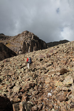
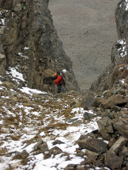
 We stuck with the trail on up into the upper basin, following it along the crest of the moraine and up toward the scree fan that we knew would be at the base of the couloir we were to climb. And sure enough, after we finished off a bit more talus climbing, we got just what we bargained for, a fan of scree and a steep gully leading to the south ridge. This couloir would be great as a snow climb and if given the choice, June would be the month to climb this peak, but it was September and we were there . . . so on up we went. Two steps up, one back, repeat, do this for a short period of time and you will We stuck with the trail on up into the upper basin, following it along the crest of the moraine and up toward the scree fan that we knew would be at the base of the couloir we were to climb. And sure enough, after we finished off a bit more talus climbing, we got just what we bargained for, a fan of scree and a steep gully leading to the south ridge. This couloir would be great as a snow climb and if given the choice, June would be the month to climb this peak, but it was September and we were there . . . so on up we went. Two steps up, one back, repeat, do this for a short period of time and you will 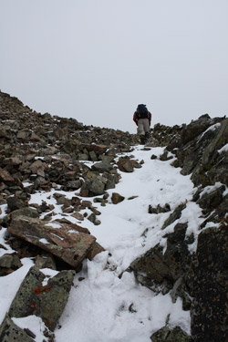 do what I chose to do, aim for the right wall of the couloir and scramble up using the sides of the slot for hand holds and hoping for a minimal amount of scree filled gaps to cross. That scenario works for the better part of the lower half but then the wide couloir gives way to a more narrow slot for the final few hundred feet of vertical. do what I chose to do, aim for the right wall of the couloir and scramble up using the sides of the slot for hand holds and hoping for a minimal amount of scree filled gaps to cross. That scenario works for the better part of the lower half but then the wide couloir gives way to a more narrow slot for the final few hundred feet of vertical.
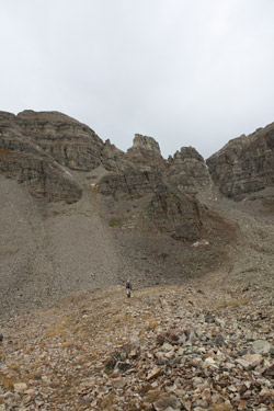
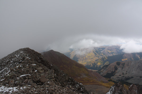
As the couloir narrowed, we crosssed more loose gaps filled with wet scree . . . grab, pull, slide back, dislodge rock, grab, you get the idea. Needless to say, if you have a party behind you and this slot is not snow filled, the party behind should have their accidental death and dismemberment premiums paid. We fought our way through the scree, which was now turning to mud as the clouds that were holding back, opened up an dumped "dippin dots" ice pellets to compound our upward wallow. Alas, we gained the last 200 feet and were on the ridge, looking up the route to the summit. The ridge was advertised as a class 2+ route and that is exactly what it turned out to be. The 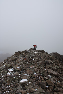 route however is not direct and cuts first to the left and then back right to the ridge proper before gaining the summit. With the summit came the clouds and where we could once see as far as Capitol, we could now see but a glimpse here and there of Castle and Conundrum, just a relatively short distance away. route however is not direct and cuts first to the left and then back right to the ridge proper before gaining the summit. With the summit came the clouds and where we could once see as far as Capitol, we could now see but a glimpse here and there of Castle and Conundrum, just a relatively short distance away.
We did not loiter on the summit as the weather was deteriorating, not in a threatening manner, but to the extent that it was not going to get any warmer and the ice pellets that stopped ten minutes before were not going to hold off too much longer. We shot a Goo, took a sip, and were off to retrace our route back down the ridge to the saddle, perhaps four or five hundred vertical below us. We more or less retraced our upward course down through the snowy ledges, giving thought to the ankle breaking descent of the couloir that awaited us . . . or did it? We reached the top of the slope and heel stepped our way on down the first couple of hundred feet, sticking toward the sides and descending 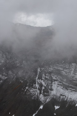 easily. We hit the wider section, the scree deepened and we more or less slid to the bottom on a wave of loose rock. I am not a scree skier by habit or intent but the melting ice lubed slope was not going to give an alternative means of descent this day. We bottomed out and talus hopped until we caught a trail segment and were off from there. easily. We hit the wider section, the scree deepened and we more or less slid to the bottom on a wave of loose rock. I am not a scree skier by habit or intent but the melting ice lubed slope was not going to give an alternative means of descent this day. We bottomed out and talus hopped until we caught a trail segment and were off from there.
We stuck with the trail to the top of the large boulder slope above the lake where we intercepted the trail from our upward climb. Seeing no reason to reinvent a descent route, we stuck with the trail that takes one across the top rather than along the base of the rocks opposite the lake. The trail 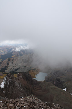 provides and easy retreat before coming to a semi stop in a ravine full of, at least on this day, very wet willows. If you go through rain soaked willows, you get wet and I don't care if you are even swathed in Gore-tex, you're gonna get wet. I was not going to get that wet so I cut back toward the lake along the base of the rock slope, figuring to intercept the creek where we crossed and hike the trail out. Ed poked about the willows but then gave into my plan and followed my course skirting the rocks and willows on the narrow ban of grass at the intersection of the two. If you climb this route, take this hint and circle back around the base of the rock slope to the trail . . . provides and easy retreat before coming to a semi stop in a ravine full of, at least on this day, very wet willows. If you go through rain soaked willows, you get wet and I don't care if you are even swathed in Gore-tex, you're gonna get wet. I was not going to get that wet so I cut back toward the lake along the base of the rock slope, figuring to intercept the creek where we crossed and hike the trail out. Ed poked about the willows but then gave into my plan and followed my course skirting the rocks and willows on the narrow ban of grass at the intersection of the two. If you climb this route, take this hint and circle back around the base of the rock slope to the trail . . .
 From the creek crossing, we cut up through gap in the willows, hit the highway of a trail leading to Cathedral Lake and started hoofing it for the car. The rain came on a bit,just enough to get me to put the soft shell on and then it would quit five minutes later and the shell would go back onto the pack. But all in all, the rain held off until we covered the whole 3+ miles to the truck at which point the skies opened up. From the creek crossing, we cut up through gap in the willows, hit the highway of a trail leading to Cathedral Lake and started hoofing it for the car. The rain came on a bit,just enough to get me to put the soft shell on and then it would quit five minutes later and the shell would go back onto the pack. But all in all, the rain held off until we covered the whole 3+ miles to the truck at which point the skies opened up.
Not a bad weekend, the South Ridge of the South Maroon Bell and then a climb of Cathedral Peak, a Centennial summit. Twenty-one miles, 8500 feet of vertical, two racks of ribs, one dozen Hostess chocolate donuts and one hour of stop and go on I-70 . . . Colorado climbing at its best.
Hagerman . . . another Elk Range Centennial
|
