|
||||||||||||||||
|---|---|---|---|---|---|---|---|---|---|---|---|---|---|---|---|---|
Storm Peak (Salvaged Pagoda Peak Attempt) –February 14, 2004 - Ascent via Glacier Gorge, descent – North Longs Peak Trail – Winter
My wife concluded her greeting upon my arrival home by saying, “So you went looking for trouble . . . and you found it. Well, we did not go looking for trouble unless that is how you define climbing in the winter. She said it with a smile so all is well that ends well. Regardless we had a Canadian style full day out for our climb of Storm Peak.
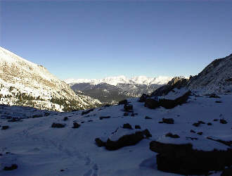
We left the Super 8 Motel at 4:30 and headed for the climb. We did not know where we were going to climb and initially the starry sky cried out for another attempt on Fairchild Mountain in the Mummy Range. It would have been our 3rd attempt on that peak in the winter but as we made the call to take the Fall River Road entry to RMNP, we opted for a shorter day. The Mummy Range Peaks in the winter call for 12+ hours of hiking and 14 or more miles on snowshoes. We just did not want that long a climb. Instead, we headed for the Glacier Gorge trailhead where we would have shorter options like checking out the ice climbs near Black Lake, climbing Storm Peak via the long ridge leading up from the North Longs Peak Trail, or taking a shot at Pagoda from the head of the gorge.
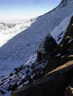
The trail to Mills Lake was a snow packed highway as we had expected following our climb of Thatchtop in January. We made good time to and across the lake and then headed further up the valley to Black Lake. Neither Gary nor I had been beyond Mills Lake but at the very least we wanted to check out the ice climbing areas we had seen at Black Lake during our Thatchtop climb. The route to Black Lake as signposted . . . literally. We got to the place where the summer trail turned off in a switch back and someone had drawn an arrow in the snow, pointing up the drainage, as well as written “summer only” adjacent to the turnoff. We stood there and looked at the writing in the snow and figured anyone who would walk 3 miles in and then leave directions in the snow could not be all bad. We took his/her cue and headed up the drainage. The route took us right to Black Lake, up and over the snow covered rock headwalls atop which the lake sits.
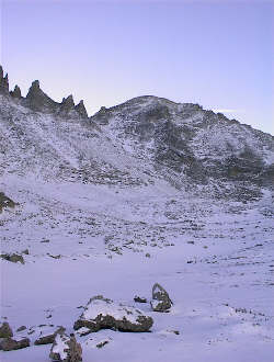
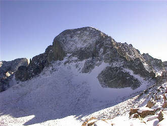
Neither of us had done Storm Peak as it is a lower 13’er and a fair walk in. Not that we did not think it worth the effort but we figured we would do it via a creative route rather than just hiking up the standard Longs trail to the Keyhole and tagging the peak. Creative route was about to become an understatement. We watered and ate and then headed on up the rocky high ground separating the Trough from the next couloir over. We figured to climb about half way up and then move to the north to hit the right spot on the skyline. The climbing was over snow-covered talus and generally not bad except when the rock got slabby and sloped downward. Getting one’s footing on such ground is hard and the effort usually comes after one goes crotch deep in the soft fluff that has accumulated at the fore of the slab. We left the base at 10:00 and figured to hit the skyline at noon or so . . .
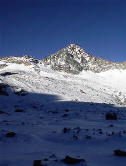
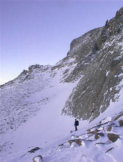
It was now nearing 2 p.m. and we were a long way from the car. No worries, we were at the Keyhole and we knew we were not the only ones to have come to this point in the recent past. After a brief debate, we agreed to tag Storm Peak and then take the packed trail back to the car. A cakewalk. Storm Peak turned out not to be a piece of cake for two climbers pretty darn tired from the climb out of Glacier Gorge. We dropped from the Keyhole about 25 yards and traversed to the upper edge of the snow slope that guards the summit of Storm Peak. We moved the along the snow rock interface and finally came to a short snow path that led to the summit. We must have stopped every 50 feet until we got to the top and I know that I put a hand into the steps kicked by Gary more than once on the way up. We summitted.
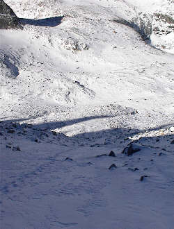
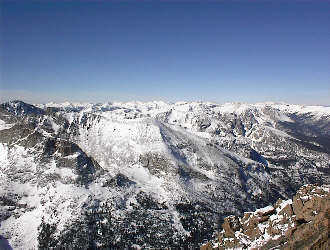
Going back down the route we came up was do-able but neither of us wanted any part of it when a graded trail to the car was within easy reach. We needed only drop to the Boulderfield and then hike to Granite Pass and take the North Longs Peak trail back to Glacier Gorge. We dropped to the outhouses and then hoofed our way quickly down to Granite Pass. The trail was packed but had not seen a great deal of traffic lately. We figured that with a good day like this, there would be a party or two on the North Face of Longs and the trail would be in good shape. Not the best of shape but given the clear day and wind blown terrain, we walked trail to the Granite Pass junction.
We could see the route as it fell from the pass to the tree line below and then cut through the trees to near the valley floor before cutting across the forested moraine at the base of Half Mountain. Off we went to our first checkpoint, Boulder Brook at 3.3 miles. The trail above tree line was obvious and though drifted over here and there we did not need the snowshoes yet. Below tree line, we figured we might need them, but eventually we would hit the packed trail created by the masses . . . Boulder Brook at the worst. We continued to make good time down, stopping here and there for a drink or to take a look at terrain below. We hit tree line an hour after leaving the junction, likely about 4:30. There we were tossed the next curveball. We both had heard the admonitions about the importance of knowing where the regular Longs Peak Trail cuts the tree line and now where we are on the irregular Longs Peak trial, at tree line, looking at the white winter’s majesty and no obvious trail. We went back to the last known trail point and each walked a given distance in opposite directions. I cut the trail and Gary came to me. We headed down. Five minutes later we repeated the routine and again, I cut the trail, so on down we went. Five minutes later, we repeated the routine but this time, neither of us cut the trail.
We knew from our observation above that the trail cut was substantial and that if we headed down slope, we would cut a lower switchback. We took the direct route down and those snowshoes became skis as we dropped through the thick timber. We dropped perhaps several hundred feet before breaking out into an obvious tree cut, we were on trail again. We shoed back and forth along the switch backing trail before again losing the route. We took to the timber and after another powdery detour, we hit the trail cut and made our way along the still untrodden path. We still had good light and we could see where we were in conjunction with the route on the topo map. We arrived at Boulder Brook AND our first sign of other snowshoe travelers. The going got easier as we followed the obvious route and had the advantage of the other person’s trail through the powder. We made a good pace and soon were atop the crest of the moraine looking down onto the terminus of Glacier Gorge. However, in getting to this point, we realized that the tracks we were taking advantage of were made by a fellow who at this point in his travels was pretty well turned around and no longer using the trail. Where exactly we both went off route, we did not know . . . but we had knew from the topo that the trail dropped off the moraine via a switchback and that meant that another plunging timber drop would put us back on the trail. It did. From the lower flanks of the moraine we followed trail to the timber bridge over the drainage that later gives Alberta Falls to the tourists. We were out of all but headlamp light at this point, but we knew that the main route to Mills Lake was center valley and now we could just about toss a rock to the far side. Therefore, we had to cut the packed path right about . . . now. Once on the packed path, we made serious time to the truck, no stops for Gu or Cytomax, just plain hustle. We flew down the trail and hit the parking lot right about 7 p.m. But, what a climb . . . and every time we figured the curveballs had run out, we were thrown another. In the end, experience paid off with the right responses to the challenges as each was encountered. The trip undoubtedly went long, too long, but previous winter climbing efforts paid off by providing know how when the chips were down. We came out in the dark and I know we were both very content not to have to dig into the bottom of the packs for the overnight gear we both were carrying . . . just in case.
|
