|
||||||||||||||||||||
|---|---|---|---|---|---|---|---|---|---|---|---|---|---|---|---|---|---|---|---|---|
Longs PeakMarch 16, 2003 - North Face, a.k.a. Cable Route - Winter
Gary and I had been planning to do the North Face or Cable Route of Longs Peak since last year but I am not sure if the original goal included a winter ascent. However, Ed, a charter member of our group who had not been out in over 9 months and was itching to climb, suggested taking a shot at the peak sooner than later. He indicated in an email that he had just read a book about Denali and climbing successes under awful conditions. I think it was one of those “they can, we can moments” and sure enough Gary and I quickly succumbed to the aura. We picked a spousally acceptable weekend and hoped for the best weather possible but really figured this climb had at best a minimal chance of actually happening. The weather on Longs is notorious in the winter and the odds of any particular day being very cold and windy seemed overwhelming. The other side of the coin, however, is that wind blows lots of snow off the peak and hammers the drifts that would likely cover parts of the approach trail. It never hurts to plan a climb so we all marked our calendars for a shot at Longs in the winter.
The trip turned into a turbo affair, as I had to attend a wedding in Casper, Wyoming the afternoon before the climb and would not get back to Cheyenne until the evening before the planning outing. Normally we would have gone to Estes Park, gotten a room at the Budget Host, eaten the traditional Grumpy Gringo meal, and set out early the next morning. Alternatively, we could have done the approach the day before and camped at the boulder field, below the North Face route we were planning to climb. This would have broken the climb up and let the 6 mile and ~3000 vertical approach be over with the day before the meat of the climb. Not so in this case.
We left Cheyenne at midnight and planned to meet Ed at the trailhead parking lot at 2 a.m. The weather forecast was calling for a storm to begin moving in late Sunday afternoon but the winds were supposed to remain light and the daytime highs were to get up to 35 degrees or so. The weather on Friday and Saturday had been absolutely beautiful and but for my social conflicts we undoubtedly should have climbed on one of those days or at least camped high Saturday night. We pulled into the parking lot, having guessed we would not be alone and found a half dozen cars, indicating that the promise of good weather had caught the attention of others. I’ve climbed Longs once and missed once (Keyhole), but something about leaving that parking lot at 2:30 a.m., this time in the winter (albeit a beautifully unseasonable night) makes me wonder why I am not sleeping warmly at home. Oh yea, it’s that alpine start gig. We knew however that given the distance we would have to cover to pull off this climb, we would need every bit of time before the promised weather arrived at the higher elevations. We knew the first few miles would be below the tree line and thankfully, wind free but also hoped that the CAIC forecast of gusts on the 20’s above tree line would be accurate. We did some final packing by headlamp, split up the group gear and complained about the weight. Some things got left behind but the bad news was that in addition to our usual loads, I drew the full length rope, Gary the rock rack and Ed got the extra water needed for a “full day” without the opportunity to pump water later.
Off we went up the trail that was well compacted through the trees to the krumholz groves above tree line. The route was all new for Ed but Gary and I had been up Mount Lady Washington a few months before and fully expected the majority of the trail to be windblown and we figured any drifts over the trail would be hammered hard by the wind. We were not disappointed but soon after breaking out into the open, the wind started and we had to stop to adjust layers, lest we chill all too early in the day. We maintained a good pace and took a sitting food and water break behind a large rock at the Chasm Lake trail junction below MLW. All too soon, we saddled up and started across the snowfield to the trail leading to Granite Pass, perhaps a mile away on mostly snow covered trail that occasionally crossed additionally snowfields enroute. Crossing one snowfield, we saw white shapes moving about over the rocks ahead and sure enough we walked right past a flock of a dozen or so ptarmigan.
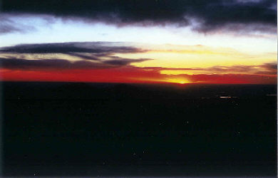
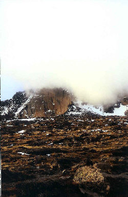
Just below Granite Pass, we sought the protection of another boulder, shot a goo and drank a bit while watching the sun finally come up over the plains below. The sky to the east was partly cloudy but a more threatening front of thick clouds was already pushing hard against the Mummy Range to the north, we figured the clock was running against us. The good news was that if things held, we would get the sun hit and at least make it to the boulder field with a degree of warmth. We moved on and as we crossed the pass, we expected to be hammered by the wind, but no . . . the air was now still. Can’t last, not on Longs at least. . . Climbing to the higher boulder field, we also got our first sight of the North Face Route and when the clouds were not blocking the heights, we could discern two climbing pairs making their way to and later through the technical pitch leading to the summit snowfields. Those pairs obviously camped high the night before and were taking full advantage of the relatively warm, 25-degree morning and lack of wind. Would our luck last?
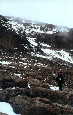
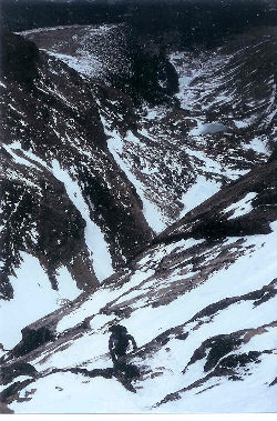
We skirted the edge of the boulder field to avoid losing any elevation and followed generally the route of what may have been the old trail, dating to the days of cables on the Cable Route. There was a snow route up from the boulder field but having watched the other groups work their way to the base of the rock climb, it appeared that the snow was slowing them down. We surmised that it might be loose and decided to stay on rock as long as possible. Our path cut out all but the last couple hundred vertical feet of snow and placed us at another large boulder adjacent to the couloir. This would be our organization stop as we wanted to harness up, get the right gear in the top of the packs, cache the extra water, and rest/eat a bit before climbing on.
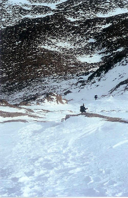
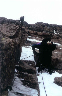
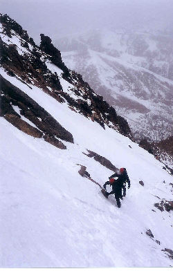
The snow filled couloir began with a shallow enough angle that I kicked some steps and recycled others using my hiking poles but by about the 1/3 mark, we all broke out ice axes to safely continue to the base of the rock pitch. The snow cover fortunately was complete enough to cover all but a few bands of rock located just shy of base of the technical pitch. We gathered below the dihedral and set some protection so that we could move about and set up for the 5.6 climb (Dawson) which just did not look that bad but for a bit of snow and ice up through most of its full rope of length. The iron loops that are most often used for anchors were obvious for the visible portion of the pitch and those descending pointed out the location of two more up and over a small buttress that obscured them from sight. However, before beginning, we waited while the earlier pairs rappelled back down; having summitted in the time we needed to make the approach from across the boulder field.
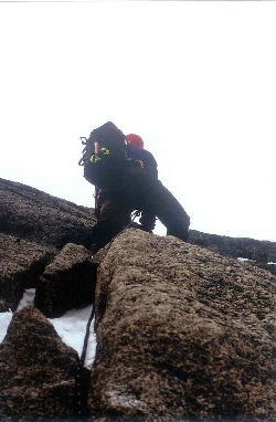
The plan called for Gary to lead the climb and for me to belay his ascent, followed by my tandem climb with Ed, both of us belayed from the top anchor. We chose the tandem option due to the obvious challenge in tossing the rope back down the slope to the waiting third climber. The climb looks easy but as we all found out, doing an easy summer climb in double plastic boots and crampons toughens the proposition a bit. It was also our first time on this route and we found this pitch deceiving, promising a fast and effortless scramble up the dihedral but delivering, to us at least, a steeper minimal handhold friction climb, not apparent until one commits to the first move. I will readily admit that climbers with more experience, like a fellow who followed us, tackle this pitch with relative ease but we found the lack of handholds a touch daunting. For some reason, we expected more angular rock but found instead a steeper version of the Homestretch with ice and snow in places, all of which made Gary’s lead a performance worthy of the respect of Ed and I as we followed. Gary did a magnificent job of placing solid pro all along the route and as we followed, we benefited from the security of a sure belay from above.
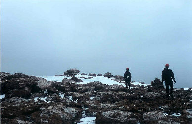
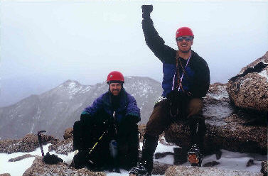
Once our team was atop the last eyebolt, we could see that the terrain was less steep and the route connected a series of angled snowfield traverses to reach the summit. We found a safe place to stash our rope and rock pro, took a short food and water break and then headed for the summit. The weather had started to arrive and though the snow was falling steadily but amazingly there was still no wind. The snowfield traverses were taken with cautious thought as the vertical face of the Diamond, a sure endpoint for any sliding climber’s career, interrupted the runout of each. The snow was firm, taking good cramponed foot placements and we crossed the snowfields safely before beginning a series of short scrambles to Longs large and flat summit. After perhaps ½ hour of travel above the technical pitch, we stepped onto the summit and walked to the highpoint to make it official. The time was 11:45 and after over 9 hours of ascent, we looked at one another, happy to have scored Longs Peak in the winter. But, not so fast . . . the snow was steadily falling, surrounding peaks were only sometimes visible, the rocks were getting slick and we were tired.
We ate, drank, and took a few photos before beginning our descent. One the way down, we teamed up with Will, who had followed us up the rock portion of the climb and suggested we join our ropes to facilitate a single pitch rappel of the dihedral, saving all of us time and exposure in the deteriorating weather. We descended as a single party, picked our way through the scramble and safely crossed the summit snowfields to the top of the rappel. The ropes were joined and Will and Gary descended to the top of the couloir below. In the mean time, another climbing party was half way through their ascent (you can safely rappel off to the side of an ascending party) and their lead asked if he could speed his climb by prussiking up our line, given the closing weather. He made quick time doing so and then Ed and I made our rappels to the base of the pitch. The correct line was pulled and the rope came slinking down the rock to be gathered and stuffed into my pack for the trip back to the cache boulder below. We were fortunate that the snow in the couloir and the summit snowfields was consolidated and in good shape (avalanche wise) for our trips up and down. We negotiated the upper steep portion of the couloir and soon arrived at the cache to again eat and drink before packing gear to make the long haul back to the trailhead. The boulder field crossing was uneventful as it is a great place for a tired party to take a rock-hopping fall. Soon enough we were back on summer grade trail and heading for Granite Pass, looking back once in a while at the mass of Longs, most of the time obscured by a veil of cloud and steady snow. As we descended, the weather warmed a bit, 30 degrees at the pass, and after another rest, we continued to the Chasm Lake junction, down through the krumholz and finally the endless hike below the tree line to the trailhead. All told, the one-day Cable route climb took 15½ hours, placing us back in the parking lot just after six in the evening. We had figured to give it a good shot, hoped the weather would cooperate, and figured that a whole hearted attempt would carry the same weight as summitting a non-technical 14’er in the winter. We ended up ticking off an official winter climb of Longs but more importantly gained some new skills that will help us on more challenging routes in the future.
|
