Mount Rainier
Camp Schurman to Summit & Return
 The 1:00 am rustle started and within a few minutes, Ed had done his duty as stove tender and mixed the proper proportion of hot water with two bags of oatmeal mix for G and I. He had the two person tent with the vestibule so he drew the task of making breakfast in the shelter of the alcove. I am not an oatmeal fan but when climbing, there is hardly the time or opportunity for a sit down breakfast of the size or character one gets on an off day. Its pretty much a make it on your hump affair and it seems to work. The 1:00 am rustle started and within a few minutes, Ed had done his duty as stove tender and mixed the proper proportion of hot water with two bags of oatmeal mix for G and I. He had the two person tent with the vestibule so he drew the task of making breakfast in the shelter of the alcove. I am not an oatmeal fan but when climbing, there is hardly the time or opportunity for a sit down breakfast of the size or character one gets on an off day. Its pretty much a make it on your hump affair and it seems to work.
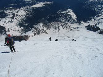
 We were out of the tents by about 1:45 and preparing the rope, harnesses and assorted accouterments of the climb. I was to lead so I set the rope up for a team of three and soon enough we were tied in an ready to set off for the summit, more than a few hours away. We were the only group leaving the camp at this time but we did see a group or as we found out later, a couple of associated ropes that had about an hour head start on us. They were well on their way up a smooth slope known as the Corridor when we left camp. We were out of the tents by about 1:45 and preparing the rope, harnesses and assorted accouterments of the climb. I was to lead so I set the rope up for a team of three and soon enough we were tied in an ready to set off for the summit, more than a few hours away. We were the only group leaving the camp at this time but we did see a group or as we found out later, a couple of associated ropes that had about an hour head start on us. They were well on their way up a smooth slope known as the Corridor when we left camp.
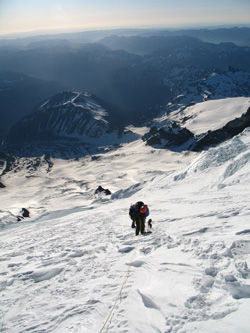
 There was no set boot track up the glacier but we had a good bit of star light and knew that the first light of dawn was going to come very early, like at around 3:30 at the latest. The first part of the climb crossed the Emmons Flats, a relatively flat area leading up to the start of the Corridor. There were a few minor crevasses here and there but nothing that was more than a step over or more commonly, a ripple in the snow surface. The broiling sun of the previous day had really cooked the snow, hence the only tracks that were clearly visible were those of teams descending the previous afternoon. There was no set boot track up the glacier but we had a good bit of star light and knew that the first light of dawn was going to come very early, like at around 3:30 at the latest. The first part of the climb crossed the Emmons Flats, a relatively flat area leading up to the start of the Corridor. There were a few minor crevasses here and there but nothing that was more than a step over or more commonly, a ripple in the snow surface. The broiling sun of the previous day had really cooked the snow, hence the only tracks that were clearly visible were those of teams descending the previous afternoon.
I managed to pick out a strong track, going the wrong way (descending), and worked my way to the right hand turn at the start of the Corridor. This portion of the route climbs steadily upward and is bracketed on both sides by drop offs and crevassed areas. We climbed on steadily through the Corridor, gaining about 700 feet in the process. By the time we  reached the top of the Corridor, we had sufficient sunlight to efficiently spot the route up through the more active portion of the Emmons Glacier, so I thought. reached the top of the Corridor, we had sufficient sunlight to efficiently spot the route up through the more active portion of the Emmons Glacier, so I thought.
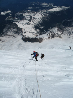
The top of the Corridor is flanked by a couple of seracs and after passing through them we plodded along a line of tracks set by previous parties. What we did not know was that at some point we had passed what, at the time of our climb, was the standard route up the glacier to the bergshrund. We continued and wound our way through a crevasse field and then came to a fork in the road. The left fork cut over to a steep slope where a track appeared to work its way up through a number of big seracs to gain the shoulder of the glacier. The right fork headed away from the direction we knew we should be taking to gain the summit.
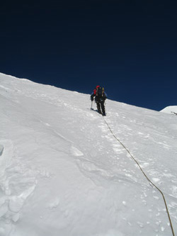
 "Right" looked like it went onto some very steep ground and left looked to be taking a good bit of traffic as compared to the right, which had a distinct "one party" look to it. We took the left and within just a few hundred yards the traffic level that had helped guide our decision had dropped to a single pair of tracks, obviously a day or two old. The route was airy as the snow was firm neve and the run outs, in case of a slip, were substantial. We'd done this enough that we were not worried about a fall so we plodded on and after a half mile and a couple of upward jogs, we made a hairpin turn back and climbed the slope in the opposite direction. Route finding was not really a matter of choosing a direction but instead had become a game of picking and choosing a path that would yield the most consistent neve as there was lots of powder to post hole in. "Right" looked like it went onto some very steep ground and left looked to be taking a good bit of traffic as compared to the right, which had a distinct "one party" look to it. We took the left and within just a few hundred yards the traffic level that had helped guide our decision had dropped to a single pair of tracks, obviously a day or two old. The route was airy as the snow was firm neve and the run outs, in case of a slip, were substantial. We'd done this enough that we were not worried about a fall so we plodded on and after a half mile and a couple of upward jogs, we made a hairpin turn back and climbed the slope in the opposite direction. Route finding was not really a matter of choosing a direction but instead had become a game of picking and choosing a path that would yield the most consistent neve as there was lots of powder to post hole in.
 We climbed to where a serac, a very large serac, had collapsed and scattered itself in a debris field across the glacier. I climbed to the edge of the debris field and saw no route though the gaping crevasse field before us. I am not talking about hop over crevasses but a genuine icefall where the gaps are measured in tens of feet, both in vertical and horizontal offset. We took a drink and gu break and then reversed back in the direction we had come for a hundred feet or so to where there was a single wand set by some unknown previous party. The wand was the start of a single set of tracks that cut to the broad shoulder that we should be climbing but for being well off route. G took the lead and for about half half mile, we traversed at or about the same elevation over to a break point where we could gain a lower portion of the shoulder. We could see the other ropes ascending where we wanted to go, so we figured we would at least fail in company if this was a wild goose chase. We climbed to where a serac, a very large serac, had collapsed and scattered itself in a debris field across the glacier. I climbed to the edge of the debris field and saw no route though the gaping crevasse field before us. I am not talking about hop over crevasses but a genuine icefall where the gaps are measured in tens of feet, both in vertical and horizontal offset. We took a drink and gu break and then reversed back in the direction we had come for a hundred feet or so to where there was a single wand set by some unknown previous party. The wand was the start of a single set of tracks that cut to the broad shoulder that we should be climbing but for being well off route. G took the lead and for about half half mile, we traversed at or about the same elevation over to a break point where we could gain a lower portion of the shoulder. We could see the other ropes ascending where we wanted to go, so we figured we would at least fail in company if this was a wild goose chase.
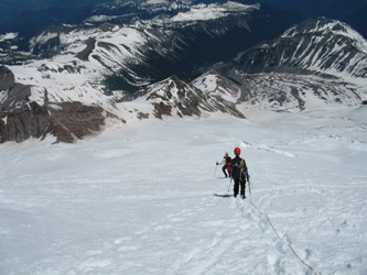
 I resumed the lead when we attained the shoulder and after I had stopped for a therapeutic dump, which appears to have become part of my morning climbing tradition. Now being of lesser weight and clearer mind, I headed on upward toward what we knew was a false summit, most likely the bergshrund at or around 13,300 feet. I was a bit tired but we kept on with a slow pace and gu stops about every hour. We cut left and cut right, snaking our rest stepping way up a relatively narrow course toward the crack in the glacier. I resumed the lead when we attained the shoulder and after I had stopped for a therapeutic dump, which appears to have become part of my morning climbing tradition. Now being of lesser weight and clearer mind, I headed on upward toward what we knew was a false summit, most likely the bergshrund at or around 13,300 feet. I was a bit tired but we kept on with a slow pace and gu stops about every hour. We cut left and cut right, snaking our rest stepping way up a relatively narrow course toward the crack in the glacier.
The bergshrund provided a minor challenge as it called for an axe to be set above the break and a quick two step jump/hop to gain the upper 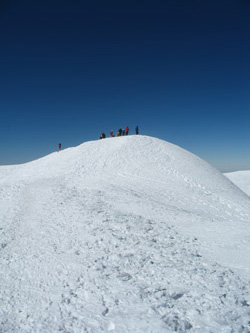 slope. We all crossed in good order and I set a wand at the top of the crossing to mark it for the return trip. The ice above the 'shrund for the next couple of hundred feet was thinly veiled blue ice. Then the snow changed back to a mix of good cramponing neve and shin deep powder, mostly where the rocks were poking through. The neve lay in bands and I picked and picked my way from band to band, just making sure that we were moving steadily upward. slope. We all crossed in good order and I set a wand at the top of the crossing to mark it for the return trip. The ice above the 'shrund for the next couple of hundred feet was thinly veiled blue ice. Then the snow changed back to a mix of good cramponing neve and shin deep powder, mostly where the rocks were poking through. The neve lay in bands and I picked and picked my way from band to band, just making sure that we were moving steadily upward.
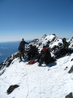
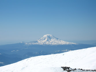
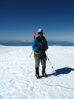
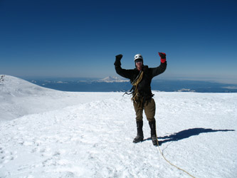
We put in another wand or two and kept in mind that the rocky ridge at the top of the sight picture was the crater rim. From the bergshrund it does not appear to be that far up to the summit but there is more vertical than meets the eye. In other words, it is a good piece from the top of the shrund to the crater, likely an hour for us. But . . . we got there and the crater lay before us. Off to the left were commercial groups coming up the Disappointment Cleaver route and traversing through the crater proper to reach the true high point over to our right. The climb so far had been wind free but at the crater rim, the wind whipped across the top of the peak. We also looked to the true high point and made a 10 minute rim traverse, a very windy traverse, to stand on the official summit of Mt. Rainier.
 We snapped the official summit photos and then bugged out when the guided groups arrived to do their obligatory hoorah huddle at the top. We traversed on back to our drop down point on the rim, took cover behind a stone outcrop and consumed the gummy worms that, for us, signify the achievement of a summit goal. Ed also elected to re-enlist in our group by utilizing his blue bag at an elevation greater than 14,000 feet. Climbing with Bob does not attain its true meaning unless Bob remains on the mountain or in this case descends in a blue bag. (now you have it, faithful readers . . . the true identity of "Bob") We snapped the official summit photos and then bugged out when the guided groups arrived to do their obligatory hoorah huddle at the top. We traversed on back to our drop down point on the rim, took cover behind a stone outcrop and consumed the gummy worms that, for us, signify the achievement of a summit goal. Ed also elected to re-enlist in our group by utilizing his blue bag at an elevation greater than 14,000 feet. Climbing with Bob does not attain its true meaning unless Bob remains on the mountain or in this case descends in a blue bag. (now you have it, faithful readers . . . the true identity of "Bob")
 We had chatted briefly with the ropes that were ahead of us and I'll say they were proud of their time to the top. Their official spokeman cited their ascent time to the minute and I knew we where dealing with a seriously uptight individual for sure. They'd scored the proper route and made good time to the summit. Now, however, we watched as they approached the bergshrund below and there was something going on that seemed to not make sense. They wandered left, then right, I suspected they were trying to figure out the route, and specifically the crossing point for the 'shrund. We had GPS points and a couple wands in place to lead the way back to the crossing but since we wanded our route after they had come up, we figured the appearance of wands on a route that previously had none had thrown the other ropes for a loop. We had chatted briefly with the ropes that were ahead of us and I'll say they were proud of their time to the top. Their official spokeman cited their ascent time to the minute and I knew we where dealing with a seriously uptight individual for sure. They'd scored the proper route and made good time to the summit. Now, however, we watched as they approached the bergshrund below and there was something going on that seemed to not make sense. They wandered left, then right, I suspected they were trying to figure out the route, and specifically the crossing point for the 'shrund. We had GPS points and a couple wands in place to lead the way back to the crossing but since we wanded our route after they had come up, we figured the appearance of wands on a route that previously had none had thrown the other ropes for a loop.
We re-stowed our gear, placed the kiwi coils over the 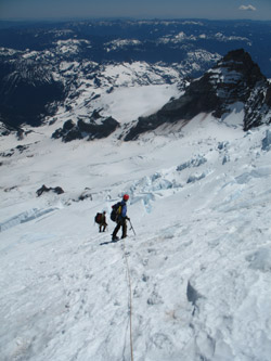 shoulders and were downward bound. We made good time going down and within no more than 15 minutes arrived in the midst of the other ropes and found out what their problem was. The blue ice that we had simply cramponed up after crossing the bergshrund had these three ropes stymied as to a safe descent. There were folks in the ice axe arrest position, folks pounding in pickets and one team just standing there, waiting patiently to enter into the fray. I hollered to G that we should play through this cluster %#@& and he advised them that we would like to continue our down climb. We watched then place pickets at the bottom of the rope as compared to setting up a point to lower the team by and/or descend by front pointing and beating their axe pickets into the hard surface with gusto. shoulders and were downward bound. We made good time going down and within no more than 15 minutes arrived in the midst of the other ropes and found out what their problem was. The blue ice that we had simply cramponed up after crossing the bergshrund had these three ropes stymied as to a safe descent. There were folks in the ice axe arrest position, folks pounding in pickets and one team just standing there, waiting patiently to enter into the fray. I hollered to G that we should play through this cluster %#@& and he advised them that we would like to continue our down climb. We watched then place pickets at the bottom of the rope as compared to setting up a point to lower the team by and/or descend by front pointing and beating their axe pickets into the hard surface with gusto.
We arrived at the bergshrund in no time as we simply walked down the slope, courteously said hello to those sprawled on the ice in the arrest position, and climbed on down the short step to the bottom end of the bergshrund. While I have no 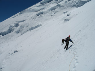 objection to taking every necessary caution when descending an icy slope, I always wonder if groups like this have done it before or if they elected to practice somewhere other than above the bergshrund on Mt. Rainier. We played through in a courteous fashion and left those three roped behind as they consumed another hour making a descent of no more than 200 feet and crossing over a filled in bergshrund via a five foot step. objection to taking every necessary caution when descending an icy slope, I always wonder if groups like this have done it before or if they elected to practice somewhere other than above the bergshrund on Mt. Rainier. We played through in a courteous fashion and left those three roped behind as they consumed another hour making a descent of no more than 200 feet and crossing over a filled in bergshrund via a five foot step.
We re-traced our ascent and wondered aloud if we had grossly underestimated the slope we walked down or if we had become careless as to taking proper cautions under such conditions. In hindsight, I think we did fine, we made a fast and expeditious descent, put distance between us and the other ropes, and were off the climb a full hour and a half before the others made it to Camp Shurman. We tracked on back to our 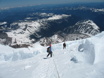 juncture point on the shoulder and then discussed whether to take the route we came up or what we realized was the standard route that was well tracked before us. We chose the standard and continued on down. juncture point on the shoulder and then discussed whether to take the route we came up or what we realized was the standard route that was well tracked before us. We chose the standard and continued on down.
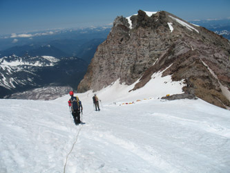
The route was indeed well tracked but after dropping another 1000 feet we ended up off to the side of the proper path and bushwhacked down a side slope and over to the track that we had made that morning. The bushwhack followed a set of tracks by another team, likely the two man rope that we had greeted on our climb as they descended from their climb of the Liberty Ridge route. The path took us along a steep side slope, very near to 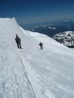 the one we elected not to ascend that morning, but within ten minutes deposited us right back onto the path we came up. From there we cut through a crevasse field using a few snow bridges and then walked through the gap between two seracs and arrived at the top of the Corridor. the one we elected not to ascend that morning, but within ten minutes deposited us right back onto the path we came up. From there we cut through a crevasse field using a few snow bridges and then walked through the gap between two seracs and arrived at the top of the Corridor.
We descended enough to be away from the two seracs that were really just ice humps and appeared to pose little immediate danger. It was time for a stop and drink and goo and most importantly a few minutes to shed a layer as the sun was up and we were all cooking. I was not that worried about a crevasse fall on the Corridor nor the Emmons Flats so off came the Gore-Tex layer and I proceeded with the white long underwear top alone. We diddy bopped on down the Corridor, turned left at the base, hopped a single open crevasse on the flats and walked into Camp Shurman with the summit of Rainier in hand.
 We melted some snow and ate a snack before giving thought to whether we would hike out this afternoon or whether we would stay a night and rest up before doing the 5000 foot drop and better part of six miles to the car. Ed took to his tent for a brief rest and was out cold in no time . . . so much so that when the NPS helicopter landed 200 feet away, he did not even stir. I felt as tired as he looked so we decided to take in the opportunity to enjoy the rest of the afternoon and evening at Camp Shurman before taking to the trail again in the morning. We had another ramen dinner, watched the other ropes wander into camp and hour or two later and partook of another ramen, pepperoni and broccoli soup combination. We melted some snow and ate a snack before giving thought to whether we would hike out this afternoon or whether we would stay a night and rest up before doing the 5000 foot drop and better part of six miles to the car. Ed took to his tent for a brief rest and was out cold in no time . . . so much so that when the NPS helicopter landed 200 feet away, he did not even stir. I felt as tired as he looked so we decided to take in the opportunity to enjoy the rest of the afternoon and evening at Camp Shurman before taking to the trail again in the morning. We had another ramen dinner, watched the other ropes wander into camp and hour or two later and partook of another ramen, pepperoni and broccoli soup combination.
 The camp filled as the afternoon went on and we listened to the pre-climb briefings provided by Alpine Ascents guide to his clients before getting dinner into them and getting them in bed only to wake them at 11 that evening to head for the summit. We also watched the clouds start to build and a touch of wind come in before we hit the tents at about 9 pm, knowing that we too would undoubtably be awakened at 11 as the other camp residents set off on their trip to the summit. (Hats off to AA, their briefings were dead on and their clients were up and out with a minimum of fuss and hub-bub). Sleep came again after the morning climbers left and the only noise was the growing wind. The camp filled as the afternoon went on and we listened to the pre-climb briefings provided by Alpine Ascents guide to his clients before getting dinner into them and getting them in bed only to wake them at 11 that evening to head for the summit. We also watched the clouds start to build and a touch of wind come in before we hit the tents at about 9 pm, knowing that we too would undoubtably be awakened at 11 as the other camp residents set off on their trip to the summit. (Hats off to AA, their briefings were dead on and their clients were up and out with a minimum of fuss and hub-bub). Sleep came again after the morning climbers left and the only noise was the growing wind.
|
