|
||
|---|---|---|
Fuller PeakNorth Ridge Variations - May 8, 2011 - Spring Snow
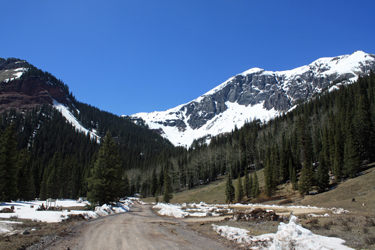
A close but no cigar climb on Sneffels two days before led us to move south to Silverton and take a shot at Vermillion . . . in the hope that we could at least claim one summit for the long weekend. We gave thought to Niagara and Jones but opted instead to try Vermillion as we could camp at the South Mineral trail head. We'd had a good lunch in Ouray before coming south in the afternoon so after checking out trail heads we elected to cook dinner on the tailgate of the truck at the South Mineral campground. Of course, the campground was not open but the day use parking area was inviting and sufficiently flat for our short duration one tent need.
The trail next cut straight across the hillside for about a quarter mile before we lost it again in thicker woods and could not pick up a carved up aspen to confirm we were on route. By this point, we had enough light to let us just cut through the trees to an open draw that we knew we'd have to cross to mount the headwall that led a hanging valley above. We gave up on the trail and just cut out into the open area where the snow was still frozen. The crampons went on and we traversed up toward the headwall, never picking up a trail or even a trace and therefore choosing the best route for a slow pace crampon cruise. For all the boost I'd had in picking out the route up through the switchbacks, whatever energy I had now seemed to be gone. I'd made a bad move on Sneffels by not using enough sunscreen and then I compounded the matter by taking an hour's dip in the Ouray hot springs The next challenge was to mount another headwall that led up into the upper valley and to do this, we picked a gully off to the left. The snow formed a steep almost vertical face but to the left there was a slot between the wall and a dividing outcropping that had a lesser angle and made for the best route up. We both gained the upper ground and then I led off in the direction of Golden Horn. I cut a long sweeping traverse up the first rounded rise of a bit more than couple hundred vertical feet, using the traverse to avoid the steeper ascent that would have come from a direct frontal approach. The snow took our crampons well but was already soft We found similar slope atop the first and again we ascended in a curved traverse, sweeping up the flank of the next hummock as we took in the view of mine ruins below and held the hope that this would be the substantive hill before we would be able to see the base of our planned climb of Vermillion. Fortunately, it was the last one as I was getting back up to speed as we were traversed to the base of the peak proper. I was unable to pick out the Vermillion Dollar I was feeling a bit more chipper but not kicking 600 feet worth of chipper, so Ed took the lead and kicked a fine set of steps up to shallow couloir to the ridgeline. I followed close behind and within about 30 minutes we were on the ridge proper and beginning to climb toward the summit. The route showed strong segments I'm not ashamed to write of my dumb climbing mistakes as I've got 150+ 14'ers and/or Centennials under my belt but this was an old school winner . . . we did not give thought to the checking the map. I had it in my mind that Vermillion anchored the ridge and that was all there was to it. I was wrong and a glance at the map would have resolved my error. Regardless, we moved on to the summit, took in the view and with little fanfare claimed the summit of unranked Fuller Peak instead of Vermillion after about a 7 mile approach and the better part of 4000 vertical feet. Our only consolation prize was that the entire top of the now obvious Vermillion Dollar Couloir was overhung with a rapidly warming cornice of major We elected not to descend the steep route we climbed and instead cut to the ridge connecting Fuller with Vermillion and then dropped down a less angled slope to the bottom of the basin below the start of the Vermillion Dollar Couloir. There I picked up my helmet, which had come loose from my pack in class 3+ terrain (don't go there) an hour or so before and taken a slide for every bit of 1000 feet. Helmet recovered, we traversed back to the top of the slope overlooking Fuller Lake and deftly retraced our ascent route. I say deftly as it was now quite We returned to the split drop above Ice Lake and put snow shoes back on as we were now sinking well beyond the mid calf and I just didn't want to put out any extra effort as we were looking at a drive back to Cheyenne as soon as we were back at the truck. We put the snowshoes on at the edge of Ice Lake and hoofed our way back through the woods to the top of the drop over the first headwall. The terrain was too steep for shoeing down and I wanted not part of the shoes if the warming snow had a mind to move. We again carefully made our way down the steep portion of the slope and then, again with shoes, made our way back to the trail traversing the hill above the campground. Rather than work our way back down through the woods, we elected to cut to the Clear Lake Road, which we hiked to the main road and then backtracked to the truck. Not a bad climb, an unranked Bicentennial summit in lieu of the sought Centennial, a full day of 10 hours out, and the opportunity to see a new valley for the both of us. I'll be back for the "right" peak and, yes, I'll know which mountain to climb!
|

 We knew from our Sneffels climb that the snow would be deep and that it would warm quite early in the morning. We set the alarm for 2:30 a.m. and were up and on the trail by 3:15. The trail out of the campground was already flowing with snow melt, hence we had a hint that the trail up through the woods would offer up a selection of either snow hummocks or just plain continuous snow. The answer was mostly snow with a bare spot here and there between extended stretches of deep mushy drifts, soft enough to drive us to don the snow shoes within the first 15 minutes of the climb. We'd not been on this trail before and with the snow pretty much covering the ground, staying on route became a game of hide and seek as we picked out a cut tree trunk here and there and connected them with undulations in the snow indicating a cut bank on the side of the trail
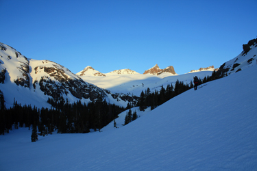 About half way up through the advetised twelve switchbacks, we came to a route finding impasse, the first creek crossing, where we did not initially catch the cross over so we ended up pushing up the stream proper for a few hundred feet or more before turning back. Again, we could not spot the route and again we pushed back up the stream. That just was not the route . . . so on the third try, I crossed the stream on the assumption that right or wrong, it would be better than trying the force the steep ground along side the water. I scored and picked out an undulation that led to a few feet of bare ground, showing the beat down character of summer trail. Our route up through the twelve switchbacks was off and on, off and on trail that is, as
 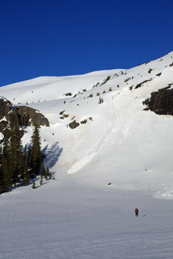 we climbed to eventually intercept the tail coming from the Clear Lake Road at the waterfall mentioned in the guidebook.
 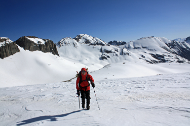 pool wherein I toasted the torso and thighs to match the job I'd done on the face the day before. At this point, I was hurting here and there but more than anything I think the exposure had just sapped my strength after a bad night on the ground. Ed made time to the snow slope leading up the headwall while I dragged along behind, steady but slow. We climbed the snow leading up to the valley holding Ice Lake and once atop the wall, stopped to take a breather and plot out a course. We thought of holding elevation and skirting the valley but I suggested we drop down a bit and just go up valley slightly left of center, whichthat proved to be a good course. Perhaps 20 minutes later we popped over a
 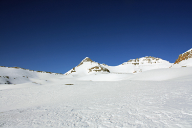 slight rise and dropped slightly down to cross the well frozen surface of Ice Lake.
 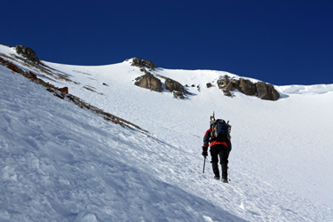 enough that there was no need to break out an axe in case of a fall. While there had been a night freeze, it was not to such an extent as to make serous pro a requirement as the sun began to warm the slopes . . . the hiking poles would do . . .
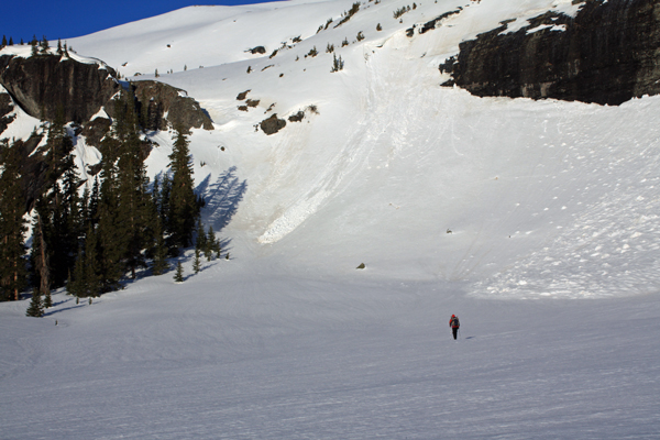
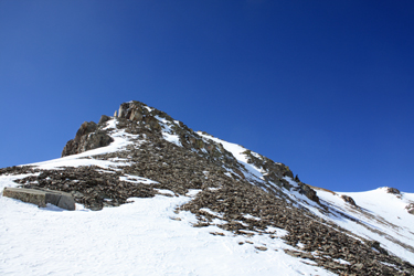 Couloir, our planned ascent route, but we figured it would make an appearance as we swept around the base of the ridge that projected from the peak. We gained ground steadily and after we got around the base of the peak, we had to choose between a direct climb to the saddle ahead of us or a hard left and steep snow route that would take us to the ridge proper.
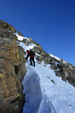 of climber's trail here and there, but much of it was under a coating of ratty snow. We made a couple of Class 3 moves to get up the crumbly ridge and were soon within about 100 vertical feet of the summit. For some reason, this was when the light came on for the two of us, at the same time. We wanted to climb Vermillion but clearly were not doing so. Vermillion was about 1/2 mile away across the valley and we were on a subsidiary peak.
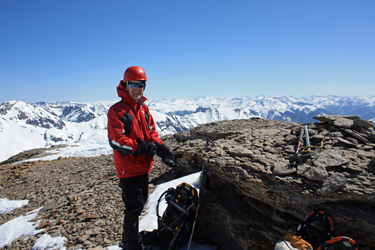 proportions. I'd love claim the ecuse that we had known what we were looking at and been unable to climb the route due to the cornice. Well . .. we'd both just covered a long approach and enough vertical to make it a good day so Fuller it would be.
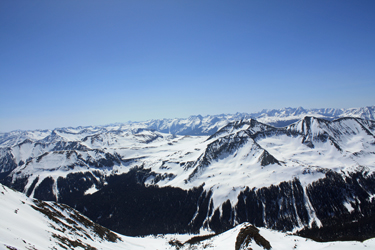 warm and the slopes were loaded with lots of wet snow. For all the alpine start we had, we'd simply lost too much time working our way up through the first part of the climb. Therefore, we now faced soft and deep snow on the upper valley slopes, deserving of much respect as we chose the least angled slope.