|
||||||||||||
|---|---|---|---|---|---|---|---|---|---|---|---|---|
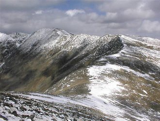
Argentine Peak and Mount EdwardsSeptember 29, 2002 - via Waldorf and the Argentine Pass Road
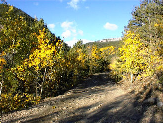
Squaretop Peak, Argentine Peak, and Mount Edwards form a chain of high 13’ers linking the Bierstadt/Evans group with the Grays and Torreys combo. I had already climbed Squaretop so, with the wife out of town, it only seemed logical to try the remaining two. My original plan was to go on Saturday but when the alarm went off at 5 a.m., I reformulated the plan for a Sunday morning departure. Not part of the original scenario but quite logical given I had to make a solo drive down the Front Range after a week of commuting between Cheyenne and Laramie. Anyway, I had plenty of stuff around the house to do and the weather was going to be good both days, so they said. I did manage to get up the next morning with more than enough enthusiasm to get on the road at 5:15 and to the trailhead by 8:30. I had a copy of the High 13’ers guide and planned to park at the Waldorf mine site, supposedly just 4 ½ miles off the Guanella Pass Road. The 4.5 mark came and went on the odometer and I finally arrived at the mine site after 6.2 miles of no challenge 4WD travel (I later saw a guy up there in a VW Vanagon). The road has a few tight climbing hairpins and some rock and rut obstacles but in no way compares to any of the epic Sangre de Christo routes. The drive up the dirt track took about ½ hour and for anyone out of state or just unlucky enough to not get to the high country in the past few weeks, the aspen were changing fast, and a few patches were already bare for the winter.
I parked on the muck pile, more properly a tailing pile (I am a mining engineer and get carried away sometimes), and gathered my light pack for what I assumed would be a breezy walk up, at least to the snow line. Edwards was not obvious to me but Argentine was right in front and already fitted out with a mantle of white, you guessed it, September snow. I considered this, swapped out my light layer for a heavier one and put on my gaiters before I even started the hike. I set out up the Argentine Pass Road, which is the easiest route to the saddle between the two peaks and a classic Colorado historic route.
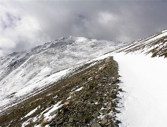
The correct path is obvious if you have a bit of mountain sense (go up when climbing/descend when going back to the truck) and the first mile of so was snow free. From there on, however, the road was snowbound and in some places drifted to an appreciable depth where the side of the road cut into the mountain. I was about ½ way to the pass when a couple from Golden passed me and indicated that they too were headed Argentine Peak and perhaps beyond. At that point, however, I was not sure where I was going. For me, solo climbing is a two phase program, the initial fight to altitude, when I wonder why I’m not at home in bed, and the 13k+ phase where I delight in the solitude and challenge. Therefore, if I make it through the first part, the second is a breeze. The problem this morning was that I was chilling in the buffeting wind (of course I added a layer) and watching clouds zoom across the sky at a respectable clip. I stopped a few times and wondered what the ridge route to either of the summits would be like and questioned whether I really needed to find out.
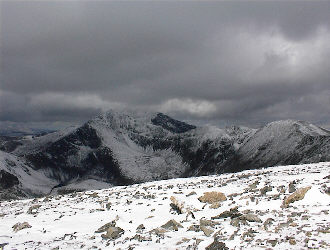
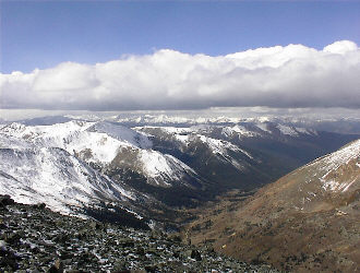
I kept walking and soon enough made the saddle between the two peaks. Argentine was my primary goal so south I went across the rolling connecting ridge to the knob of high ground directly blocking the peak’s ridge route. Rather than do an up and over, I traversed around the flank and then made the trek up the summit ridge. The terrain was easy going all the way and after a bit of continuous hiking, sometimes through snow over a foot deep, I arrived at the top. The climb was worth it for the view alone as the Mosquito Range to the west was blanketed in fresh snow. I took some photos and observed snow squalls moving in my direction, pushed along no doubt by the wind that had made my trip to this point an adventure in climbing lee slopes and leaning in one direction. I had had enough and headed back down the spine of the peak toward the pass road.
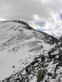
On the way down, I kept looking at Mount Edwards and saying to myself that it’s summit was just a mile past the saddle, that the squalls were not going to wipe out the visibility completely and that I could just bop over there. Therefore, since I was tired . . . I climbed the ridge leading toward Edwards in the wind and sleet (makes sense right?). The route was obvious as was the escape path in the event the visibility quickly went sour (compass and map in pack). Edwards and McClellan form an amphitheatre that I figured would just about funnel me back to the truck. Additionally, the funnel route would cut the Argentine Pass road, which again meant a route to the truck. The squalls did not look to be settling down to the 13 or 14,000-foot level, but I was remembering our Squaretop climb where the clouds quickly dropped right onto us on a very similar day.
The route to the rounded top of Mount Edwards is another easy ascent of a broad sloping ridge, with bumps here and there to keep me thinking, at least a portion of the time, about not expending extra effort by climbing over instead of traversing. It is the climber’s choice of course, but I hate losing altitude, especially when I am heading for the backside of the personal power curve. I topped out on Edwards and as anticipated, looked over the reverse side, which is a cliff dropping down into Stevens Gulch, the approach to Grays and Torries. I did not see an endless line of Cottoneers snaking their way up the valley, so I am almost willing to bet their climbing season has concluded. The weather was still windy but the squalls were abating so I just reversed my route to the head of the pass road and ambled on back down. By the time I reached the mine and truck, the effect of losing altitude was apparent, warm air, little wind, and a plethora of four wheeler types tooling around the old mine roads on a beautiful fall day. I was tired but enjoyed the wintry solo hike with Cottoneer’s start, taking about 5 ½ hours for the two-peak combination.
|
