|
||
|---|---|---|
Jupiter MountainAugust 18, 2010 - Climb via Southwest Slopes
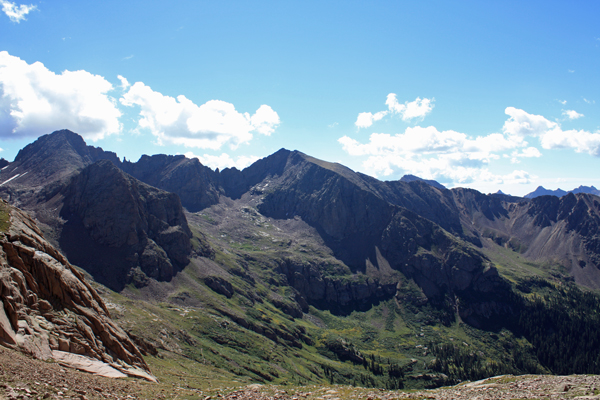
The majority of our group came to Chicago Basin to climb the three 14'ers that draw the vast majority of visitor to the basin. My compadres were to set off for Sunlight and Windom while I planned to set a course to Jupiter Mountain in an effort to climb another Centennial peak.
I looked across to the other pinnacle that is just a few feet higher and had this tell tale gray pipe cylinder that I knew would contain the summit register. I down climbed from the eastern pinnacle and crossed over to the other point. Gaining the summit proper required one class 4 pitch of just ten feet or so but with a healthy degree of exposure in the event of a fall. No fall for me so I soon walked across the top of this flat surfaced mini catwalk to the summit proper. I did not know which peak the other four would take on first but I could see a figure on the top of Windom. I waved and I down climbed the summit point and maneuvered down the rubble slot to my crossover point and back up the class 3/4 climb to the false summit. From there is was just a reversal of the ascent route until I'd lost the better part of 1000 feet and regained the strong climber's trail. I saw no reason to recreate the wheel nor add to any extant erosion, so off I went on the course of others who preceded me. The trail drops down into the large basin that lies below Columbine pass and and eventually and efficiently intercepts I made easy time down the well worn trail and was soon back in camp, at around noon. I was not alone in camp, however, as the goats had invaded and were inspecting our residence for any goods of interest. They had found none and retreated to the edge of the camp to graze through the lush understory before most of them wandered off, leaving only two to guard their rear and continue to poke about our camp in hope of an offering. None was forthcoming and after G and crew returned, the remaining few goats soon lost interest and moved along.
|

 We had been driven to the tents the night before but did set a time to get going on the assumption that the clouds would recede and we would wake to a star studded night. The game plan called for a 4:00 a.m. wake-up and departure from the camp by 5 or so. We would make the short hike to the cut off to Twin Lakes after which I would continue solo toward Columbine Pass. We set off on time and within five minutes of our start, I was on my own and watching the other four lights start the hike to the upper basin that is the route to the 14'ers. I crossed the creek and started on up the trail, taking the switchbacks that come after the second stream crossing in stride.
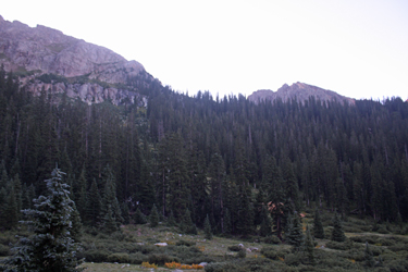
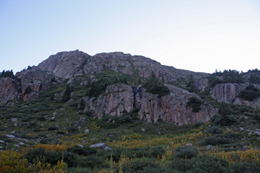
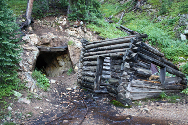 I'd managed to forget my annotated map but I recalled the view of the upper grassy slopes from a guidebook and knew from the map that I did have that I would have to pass an obvious prow before it would be time to start climbing from the trail. I walked for about 20 minutes before encountering an old mine adit and the remains of a cabin at the portal. I stopped there for a drink and thought back to the trail description, thinking there was some significance to the mine opening . . . or perhaps not? Regardless, there was now enough light for me see that I had passed the prow that would eventually form the start of the ridge that I knew led to the summit. I noted a climber's trace leaving and working its way up hill but it was by no means a strong trail nor a real trail at all
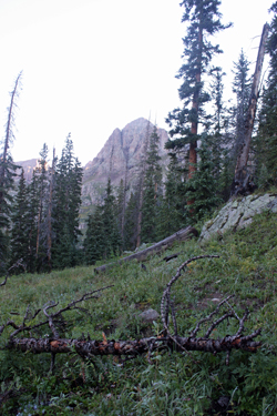 I took the trace and worked my way up to what I could see was tree line not that far above my exit from the trail proper. I trudged upward and when the ground leveled off, I broke the tree line and scored another strong climber's trace that led to an open boggy area that seemed to give a view of the climb to the upper grassy areas depicted in the photos burned into my memory. I could see that the slope was broken by a series of small cliff bands but that there were any number of routes that would grant access to the higher slopes. I chose "weakness left" and made my way about 400 vertical feet, mostly without a strong trail but never with out signs of prior traffic. Upon reaching what appeared to the the upper grassy slopes I could see that there was still a good bit of elevation to be gained. I traversed southwest and intercepted a very strong trail, leaving no doubt that I'd cut away from the Columbine Pass trail too soon and that there was in fact a trail that would likely grant an easier descent later in the morning.
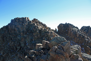
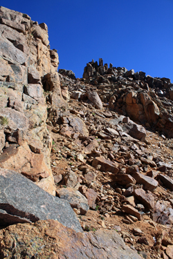
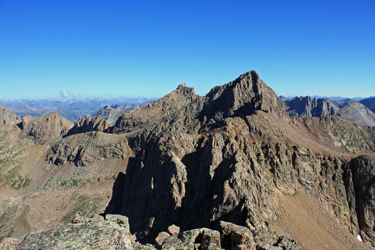
 The trail took me to the base of the pictured slope that required a gain of another 500 feet or so to arrive at the ridge that forms the remainder of the route to the summit. The summit remained invisible throughout this course but the ridge and I both continued to climb. The route stepped up from class 1 to class 2 and after a short talus climb, the summit proper came into view or appeared to. I continued up the slabby slope until I arrived at a pinnacle that granted a view of the true summit proper. The route now took two steps up from easy class 2 to class 4 at worst as I down climbed the rear of the false summit, moved across a small rocky gap and dropped down an incline to the base of a short gully that led up to the
 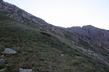 two summit pillars. I was unsure which pillar was the higher of the two, so I cut right and soon stood atop that pinnacle.
 received no response, so I took a minute for a snack and took in the view. The time was 9:30 or so and I needed only to get back to the camp to call it a day.
 the point where the creek from the basin cuts the trail. Had I continued, the cut off point would have been obvious and I would have hiked trail all the way up through the basin. Hence, in hind sight there was no reason to cut off at the mine when good trail could have been had with another 15 minutes walk toward Columbine Pass.
 G and crew had scored Sunlight and Nipper took the leap and stood atop the summit block. They did not make it over to Windom due to growing clouds but we had a weather day built into the schedule for just such an occasion. Everyone scored a new summit and after a good lunch we lounged around until the Italian sausage and peppers dinner
put the finishing touches on the day. Now for the
G and crew had scored Sunlight and Nipper took the leap and stood atop the summit block. They did not make it over to Windom due to growing clouds but we had a weather day built into the schedule for just such an occasion. Everyone scored a new summit and after a good lunch we lounged around until the Italian sausage and peppers dinner
put the finishing touches on the day. Now for the 