|
||||||||||||||||||||||
|---|---|---|---|---|---|---|---|---|---|---|---|---|---|---|---|---|---|---|---|---|---|---|
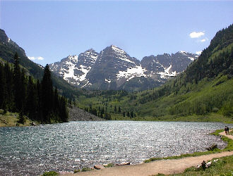
South Maroon BellJune 8-9, 2002 - Bell Cord Couloir
The Bell Cord Couloir snow climb had been in the plans for 6 months but as departure day neared, we questioned if there would be any snow to climb. Add to that factor one climber’s father going in for surgery on the day we were planning to leave and a cherry state Supreme Court appearance for the other climber on the day after our return. To salvage the climb, we resorted to the “turbo trip”, which called for a Saturday morning departure and a Sunday afternoon return in addition to dropping one peak from the game plan.
We left Cheyenne about eight in the morning and arrived at the Maroon Bells overnight parking lot at about three. The overnight lot was two thirds full (it was Saturday) and there was another group packing to head for Snowmass and Capital so we started wondering what the availability of a back country campsite would be. The plan was to try for one of the sites near the base of the couloirs that ascend the Bell’s east face and then get a very early start the next morning to ensure the snow was in good shape. The walk in took a bit over an hour and we lucked onto Site #10, which is one of the sites closest to the start of the climb, at the head of Crater Lake. We set our camp in the copse of trees and walked on up the valley a ways to scope out the approach for the next morning. Gary and I found substantially less snow than the same weekend of the previous year when my wife and I had originally gone to see the Bells and investigate the snow routes. Regardless, we noted the cutoff point to the base of the snow before heading back to the camp for a cold dinner.
The problem with summer camping and a fire ban is that boredom sets in right quick after dinner and the sun doesn’t set for a long, long time. I was beat from a long week and regardless of the remaining daylight, headed for the tent at eight o’clock. The next thing I knew, the alarm was going off, it was two in the morning! The weather overnight was warm but the skies were clear and star studded, a good omen for the snow to be hard though an overnight night freeze would have provided a more certain guarantee. I forced down a bagel and Little Debbie brownie and then we hefted our summit packs to head for the South Bell.
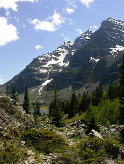
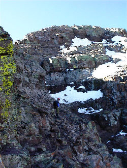
The climb up to the snow after we left the trail proper was a climb from hell. Neither of us had on our “talus feet” so stumbling was the norm for the first hour. Surely, you have been on a climb that you have looked forward to forever and then the morning of the climb, you just are not on the ball. That was Sunday morning for the both of us. We planned to climb the talus to the snowfield below the Garbage Chute and then cut right to another patch of snow that climbed to the base of an upper headwall. We planned to then skirt along the bottom of that headwall, above some scrub evergreens, and step onto the snowfield below the Bell Cord proper for the big climb. We concocted this plan the evening before and I am glad we did, as picking out the route in the darkness of 3 a.m. without some reconnaissance would have been quite the trick.
We made the snowfield connections as planned and slowly gained our climbing feet as we ascended snow instead of that damn loose talus. The headwall move worked like a charm (we obviously were not the first to pass that way as the scrub had seen some obvious traffic) and it deposited us right onto the snow atop the smaller more northerly waterfall (not the more obvious Garbage Chute). At this point, the crampons went on, as the snow was too solid to safely kick steps. However, for cramponing, the snow was in prime condition. Out came the ice axes and up the couloir we climbed.
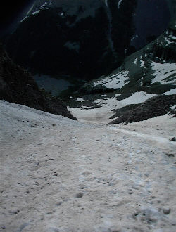
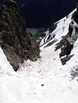
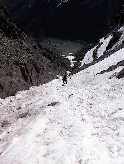
The start of the climb is through the more gently sloped basin from which the various east face couloirs climb toward the ridges above. We made steady progress up this milder terrain and then reached the base of the Bell Cord proper. The couloir appears from the trail below to be a thin thread of snow going all the way to the saddle between the Bells but once you begin climbing it, you find that there are exits onto various ledges, wide spots and narrow curving sections. Regardless, the climb from the top of the waterfall to the saddle above had a vertical gain of over 2500 feet. The climbing angle is probably about 45 degrees and the snow was hard all the way up. We carried protection, rope and pickets, but did not use them, as we were comfortable with the angle, snow conditions and our ice axe arrest techniques.
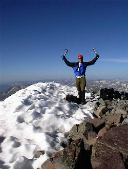
2500+ feet of snow is a long climb and the sun hit us right as we entered the narrow section of the couloir. We climbed and climbed, stopping here and there to rest but depending mostly on a long practiced rest step to conserve energy and get us to the top with power to spare. We made the saddle at about 7:15. For those who have never climbed this route, there is one thing to be thankful for as you put one foot in front of another: when you see the sky at the head of the couloir, that is the top. There is no false saddle, no hidden slope beyond to wear you out, no tricks, just the saddle proper connecting the Bells.
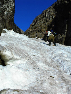
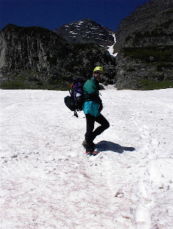
Our next task was to summit the South Bell so we dropped the excess gear and headed around the backside of the peak following a well-trafficked route. The trail climbs up ledgy ground and has all the loose stone and cruddy handholds one could ask for on a climb of the Elks. The best trail flirts with the front side of the peak but we chose (not on purpose) a path that went on around back and led us to a class 5 slot climb guarded by a tongue of snow and ice. We chose to leave our crampons, alpine axes, ice screws, and rope at the saddle but we did each bring an ice tool along just in case. We climbed the rock to the side of the ice for about 15 feet and then moved over into a half dozen very well kicked and deep steps, protecting the short snow climb with the second tools.
We completed the short climb and were back onto the front of the summit pyramid and of course, we were now looking at an obvious string of cairns, showing the proper route that we, should have taken to this point. From there, we climbed up a short stretch hand and foot ridge to the summit. The South Bell was ours.
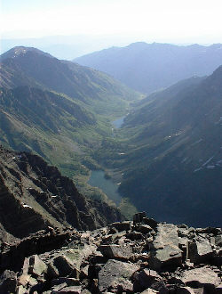
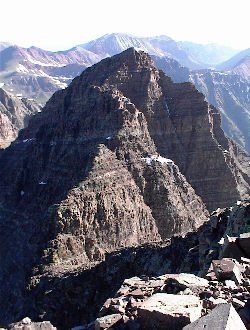
We completed the obligatory picture taking and the view of Snowmass and Capital is just incredible. On the opposite side of the valley is Pyramid Peak and nearby, of course, is the North Bell, connected to the saddle by the obviously challenging ridge traverse. The wind was picking up so we headed down from the summit to a sheltered spot for a bite to eat and then back down the ledges, via the less challenging route, to the top of the Bell Cord. We had discussed the possibility of trying the traverse to the North Bell but this was just not the day for it. We were both tired from the climb up and that ridge was obviously no place to climb unless your form is in top shape, ours was far from it.
The packs got heavy again and we put the crampons back on for the trip down. The snow was not hard but also not soft enough to kick those heels in and cruise down slope at a leisurely rate. That all translated to an invitation to take a slider as we both had steps crumble from beneath our boots. We made a slow and careful descent, each of us occasionally burying our ice axes to the hilt as we performed self-belays through the upper sections of the couloir that had seen the most sun. As we neared the base of the couloir, the snow firmed up but the inevitable happened, my feet went out from under me and I was on my back taking a slider. Get onto that belly, bury that pick, and those crampons had better not touch the snow. Do it right and you stop; otherwise, you may join the ranks of those for whom the Bells have proven their deadly reputation.
The alternate route . . . the South Ridge of the South Bell
|
