|
||
|---|---|---|
Emerald Peak & Iowa PeakOctober 10, 2010 -West Ridge from Clohesy lake
I'd not been climbing in a month, G was had not been out in two months and Bob had not been out in three . . . it was time to get out and climb almost regardless of the weather. With little to no convincing on our part, Bob agreed to bug out of work at 3 p.m. and we were soon off to Leadville in pursuit of Emerald and Iowa Peaks. I was after perhaps a final Centennial for the year and everyone else just wanted to get out of town and above 13k.
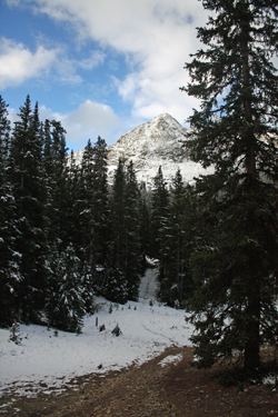
The morning dawned overcast but warm, about 31 degrees, which struck all three of us as a near miracle in Leadville where snow had been falling the night before. We were off to the trail head and after a u-turn we found the turnoff and cabins at Rockdale. Bob had been to Chohesy Lake as a kid but none of us had been up that valley for the purpose of climbing. We made the stream ford without issue, obviously a result of the season, and then stopped before the "gatekeeper" rock step just on We usually end up doing a 4wd approach in my Tacoma but this time we had the full size GMC with G at the wheel. He maneuvered up and over the gatekeeper rock step and then we were off on our way up the hill toward Chohesy Lake. The route proved to be little challenge for him but for a tight turn here and there. Unlike the Toyota, the big truck turns like it is on rails, hence here and there a multi point turn was needed to make the tight 4wd trail turns. The packs were ready to go from the night before so soon enough we were hiking up the trail to the lake. We noted that someone was ahead of us, that morning or the day before, and that he left a solid track to follow in the 2 inches of snow that we were hiking through from the start. We did not make the lake proper but cut off to the left after about 100 yards and found the trail that the guidebook spoke of as giving access to the basin that lies below the juncture of Missouri Mountain and Iowa Peak. The snow started getting a bit deeper and The stream was indeed the "cut up" point and we continued to follow the tracks of the fellow ahead of us as he led the way up a stair stepped trail to the basin proper. Once we broke the crest of the forward edge of the basin, the tracks made their way toward Missouri and we stopped to give thought to the route we would take to Iowa. The guidebook indicated that a saddle could be gained between the buttress that rises above the lake and the summit of Iowa proper. There is also an very obvious route up to the saddle dividing Missouri from Iowa that seemed to Once past the willows we could see the broad slope that led to the buttress/Iowa saddle and we discussed which saddle to aim for. We elected the buttress/Iowa saddle and in fact aimed not for the broad swale but toward a tighter couloir that would provide a route almost directly to the summit. We each took our own paths across the talus aiming for the base of the upward route but knowing that once we got close there would be another assessment as to course selection. We arrived at the decision point and elected the more broad route as there was now about 12 inches of snow on the flank of Iowa and we could see a route where we could pick our way up talus as compared to getting mired in the scree slog of a tighter and steeper ascent route. Spring snow would have proved a whole different story.
There was still no need to hunker down as the air remained still and we took an extra few minutes for some summit gummy bears and Bob partook of tuna from a bag. We spent perhaps 20 minutes on top and then debated the route down, back the way we came, to the Missouri/Iowa saddle and down, or perhaps down via the summit of Emerald, about a half mile distant. The weather to the north was not The course down the flank of Iowa was tame as we connected bare patches and early season snow patches that in some cases was hammered enough to support our weight. The drop to the Iowa/Emerald saddle took no more than 15 minutes and then we were headed up the flank of toward the summit. Rather than take a direct route, we opted for a "z" shaped course that The ridge granted us with a rocky route and with little more effort we were atop the summit of our second high 13'er for the day. The weather was holding and we could see that the saddle connecting Iowa and Emerald would yield a snow covered summer scar that would be a good course into the valley below. This route would put us one valley over from our ascent route but once down the steep section, we would only need to hike to the stream feeding Clohesy Lake and we'd hit a lake bound trail. The drop was a pain as the scree nto There was no defined course down through the woods so G made a zigging course downward and to our surprise the forest was without significant dead fall. There was the usual tree down here and there but other than a few stepovers, we never broke pace or really altered our course to avoid a zone of impassible dead fall. We knew from our viewpoint above that the stream course in the base of the valley would yield a somewhat open area and after a good 20 minute drop through the trees we did hit the open area and the valley floor proper. Our descent was quick as Bob took the lead and we dropped down through more willows into the The climb of the two peaks took about 8 hours in snow up to about a foot deep. The winds remained tame for most of the afternoon but as we drove north to Leadville, the rains came and there was no doubt snow falling on the upper flanks of the higher 14'ers of the upper Arkansas valley. But that was of no matter to us, we had a good set of wipers and mini chocolate donuts to hold us over until we arrived in Idaho Springs for dinner.
|

 Dinner was the first priority and we headed for prime rib at Quincy's, arriving at about 6:30, having driven first through rain and then snow on our way to "Cloud City." Dinner was predictably good but near its conclusion Bob opined that he thought it would be a great idea to get a room at the Super 8 in lieu of setting up the tents for the evening. Not being the kind of people who would discourage an excellent idea, we soon checked into the inn and made a rather comfortable camp that would offer us the opportunity to wake to a morning low temperature of 65 degrees and no pitter patter of rain on the nylon roof.
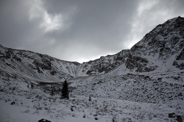 the far side of the creek. The view up the 4wd road looked ominous but after parking the truck and walking a short distance up the road, we got a better view and opted for the truck approach . . . a savings of about 5 miles over the course of the day's trip.
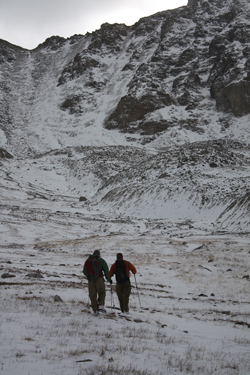 We eventually came to the large debris slide that covered the road and was flagged with ribbon as to a route up and over the slide. This is an impressive sight as the mud and rock slide not only came down the drainage from above but had spread out into the trees on both sides of the drainage. We crossed over the now solid alluvium and were back onto the road again. We soon came to an open space that we suspected was the 4wd trailhead but we kept going for another quarter mile or so to the gate that stopped all progress and formalized the end of the vehicle approach. G backed up about 100 feet and parked in an open spot adjacent to the fence.
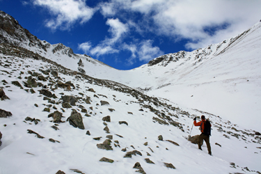 the trail was steep as it traversed well above the lake, eventually leading to a the flowing stream that we suspected marked the point where we would cut directly up into the basin.
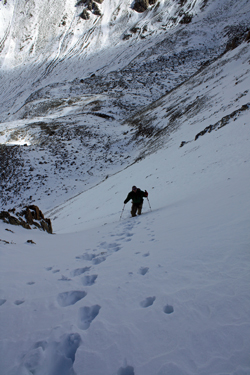 present the easiest course. We opted to stay to the left side of the drainage that led toward the Missouri/Iowa saddle, at least until we were above the last of the willows.
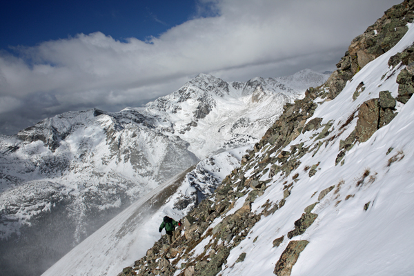
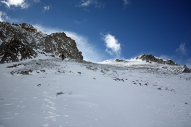 G took the lead and kicked his way up the route, slipping and sliding here and there as the barely frozen scree gave way. I followed and Bob brought up the rear as we fought the scree and about a foot of unconsolidated snow atop the scree. We picked our way to the left of a pointed pinnacle and then G cut up in along the edge of much steeper rock that provided not only a route on talus instead of scree but granted us a wind shadow as compared to the nearby terrain where plumes of snow told a far different tale as to the wind we should expect once we crested the ridge.
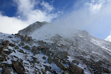 One by one we crested the ridge and entered the storm that we assumed would accompany us to the summit. While we entertained the thought of a two peak climb, the biting wind foretold a single peak climb for sure. I climbed a bit and met with with G who was taking a sit break while Bob and I caught up. We set off again and made a climbing traverse toward the summit that we knew still lay on the other side of a minor saddle. We came to a drop off that indicated the intercept with one of the face couloirs that we reached via a ramp that led to the small saddle. Now we knew we had only to climb a short distance to the summit. But something was different, the wind had stopped, literally stopped. We climbed on and
 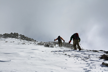 when we came to the apparent summit, it was not to be, we still had to traverse along a curved but relatively level ridge to the true high point, perhaps 100 yards distant. G and Bob set out for the top while I snapped a few photos of them and then I too made my way to the end of the climb.
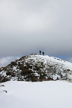 good but it was cool and the hanging scud seemed disinterested in dropping onto our part of the Sawatch. We opted for Emerald . . .
 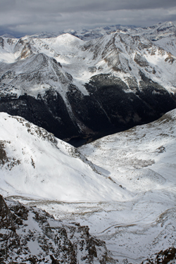 connected strings of talus that would make for optimal rock hopping. Some of the snow was hammered but higher up it was less compacted so we aimed to hit the east trending ridge and hike that path to the summit. The ridge came easily enough, still a bit of work, but we knew that there just was not enough elevation to gain to make for much more than a slog at worst.
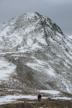 was poorly frozen but 800 or so vertical feet later, we were down on the relative flats and making good time across the snow covered middle reaches of the valley. The valley brought us to the anticipated drainage and we now entered a world of willows that filled a quite steep stream cut dropping into the woods at tree line. In summer, the cut would have been on the verge of cliffy but with a foot of snow and lots of willows to grab, we were dropping handily down the cut and soon into the woods proper.
 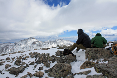 area above the lake. As we neared the lake, the valley bottom widened out and soon enough we were traversing above the lake and then with a twist here and there, we were back on the tail end of the road leading to the truck. Through the gate and fence and then we were at our starting point and done for the day.