|
||||||||||||
|---|---|---|---|---|---|---|---|---|---|---|---|---|
Atlantic Peak (winter attempt)December 8, 2002 - West Ridge from Mayflower Gulch
Gary and I both needed to get out into the mountains in the worst way, so a weekend climb in the Mosquito Range was planned. We figured to head for Leadville and attempt one or more of the high 13’ers in the Pacific group.
Our plan was going to depend on the condition of the snow pack and we were hoping for enough crust to allow us to make it to the top of Atlantic Peak and traverse around to Pacific Peak before descending. We had stopped at the Mayflower Gulch trailhead on the way to Leadville but could not get much of an idea what the snow up high would be like. The next morning we stopped at a coffee joint/bakery to get something hot for breakfast and wait for the sun to at least lighten the sky a bit before we hit the trail.
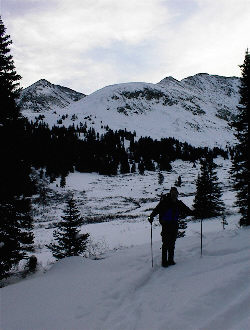
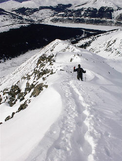
We were on the trail at 7:30 a.m. and made good time for the first mile, it is tough not to do so considering the Mayflower Gulch mine road is packed by skiers and snowmobiles to beyond the Pacific Creek cut off. We located the juncture of Pacific and Mayflower creeks at about the one-mile mark and put on the snowshoes to cross the drainage and mostly buried willows that lay between us and the start of the climb to Atlantic’s west ridge. Our plan was to go up the Pacific Creek drainage and around the backside of the ridge to make use of the more gentle topography as noted in Roach’s guide for this route.
Crossing the drainage was to be the precursor to what lay before us, 18 to 24 inches of unconsolidated snow, just waiting to slip, slide, and generally make our ascent up the drainage as difficult as possible. We stuck to the trees along side the creek’s course and mostly followed a well graded route set by some local coyote who seemed to be headed into the same general area we were. He also seemed to have the same idea we did at that point, seek out any patches of snow that appeared to have seen enough sun to develop some sun crust, no matter how little. We finally arrived in the bowl behind the ridge and set about zigging our way onto the ridge proper. The avalanche web site was had indicated low danger with pockets of moderate so we were keeping the route on the slighter angled terrain, watching for signs of unstable snow, and avoiding other practices that might increase our risk of avalanche (took the two day course before starting to climb in winter).
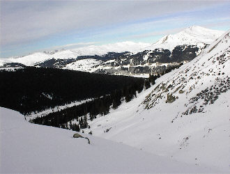
Gaining the ridge proper was a battle as the snow depth never let up, we found no wind scoured route and post holed often to the ground while using snowshoes! The only factor that was working in our favor was the lack of sustained wind, though the air temperature remained cold during the whole climb. We finally got to a point on the ridge where there were enough rocks showing to justify returning the shoes to the pack and proceeding on foot, generally rock hoping up the ridge. The first steeper section was not corniced but after that, there were sections of cornice that required post holing though knee-deep snow while assessing the snow conditions and slide potential. The lower corniced sections were tiring but provided an escape route to one side if need be. However, at 13,300 feet, our luck ran out.
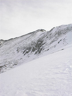
We reached a section of snow, no more than 50 to 75 feet across but without an escape route and a defined slide route leading down the most obvious avalanche track on the flank of the ridge. To top that off, the track neatly deposited its cargo over a cliff band, perhaps 1000 feet below. The pieces were falling into place real fast at this point, cornice made of wind deposited snow, laying at a 35 degree angle, no available rock route, all within just a few miles of where two folks got seriously screwed up by a slide just a few weeks earlier. We turned the climb, 500 vertical feet from the summit and figured to let Atlantic Peak wait for another attempt later in the season. Today was just not the day and that short section was probably viable but the consequences of a miscalculation were permanent. We post holed our way back down the ridge and put the snowshoes on for the tamer ground leading to the base of the gulch below. The powder on the shoes was getting heavier as the day went on and even following in the footsteps of the leader provided only partial relief and the snow simply flowed back onto the deck of the shoe to be lifted over and over again. We made the road at 3 in the afternoon and then walked on back to the trailhead, arriving one half hour later. Atlantic turned out to be a full day’s effort and provided a valuable lesson in travel through corniced terrain, most importantly putting to practice the skill most climbers would rather avoid, making the call to turn around when the summit is but a quarter mile further and in plain view.
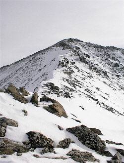
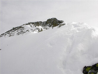
Adjacent Pacific Peak in the summer and winter . . .
|
