Peru 2011
Climb of Nevado Campa I - 18,150 ft.
June 17, 2011
Our first climb of the trip would be an attempt of Campa I, an 18,150 ft. peak that forms a flank of Campa Pass. Campa I can best be called an acclimatization peak, a climb that provides a good practice session for one of the higher 6000 meter peaks in the neighborhood. We really did not have 6000 meter aspirations on this trip, so Campa would serve as one of the substantive climbs of our expedition.
 We normally set off for a summit at 0:dark30 but due to the proximity of the peak to our camp, we elected to start instead just a bit before fist light. Domingo had eggs for G and Bob and I was quite content with cereal and tea. Everyone had what they wanted and as the sky started to grow light, we hefted light glacier packs and were on our way toward Campa Pass. We did not feel the need to equip ourselves with fill glacier gear as might be needed to scale an icy wall or extended blue ice slopes, instead relying upon our prior day's recon and the heartfelt hunch that the glacier was in good shape as we were in the early part of the dry and saw little sign of an ablation zone at the foot of Campa's glaciers or others in the area. We normally set off for a summit at 0:dark30 but due to the proximity of the peak to our camp, we elected to start instead just a bit before fist light. Domingo had eggs for G and Bob and I was quite content with cereal and tea. Everyone had what they wanted and as the sky started to grow light, we hefted light glacier packs and were on our way toward Campa Pass. We did not feel the need to equip ourselves with fill glacier gear as might be needed to scale an icy wall or extended blue ice slopes, instead relying upon our prior day's recon and the heartfelt hunch that the glacier was in good shape as we were in the early part of the dry and saw little sign of an ablation zone at the foot of Campa's glaciers or others in the area.
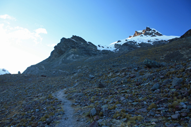
 We headed for Campa Pass, knowing that the start of the climb took off from just shy of the top of the pass. Domingo and Rocque tagged along, figuring to climb up as far as the glacier and watch our progress for a while from that point. We trudged up the hill just outside the Pachaspata camp, our legs seeming to be made of lead. We all knew the initial fatigue would pass and by the top of the first hill, we were We headed for Campa Pass, knowing that the start of the climb took off from just shy of the top of the pass. Domingo and Rocque tagged along, figuring to climb up as far as the glacier and watch our progress for a while from that point. We trudged up the hill just outside the Pachaspata camp, our legs seeming to be made of lead. We all knew the initial fatigue would pass and by the top of the first hill, we were 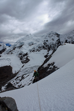 getting into gear for the climb.The route to the pass traverses the side of Campa's slopes all the way to the pass and there are alternative routes from the trail to the peak's snow line; however, we figured to take maximum time advantage of the trail rather than start rock hopping early on when our real interest was snow climbing. getting into gear for the climb.The route to the pass traverses the side of Campa's slopes all the way to the pass and there are alternative routes from the trail to the peak's snow line; however, we figured to take maximum time advantage of the trail rather than start rock hopping early on when our real interest was snow climbing.
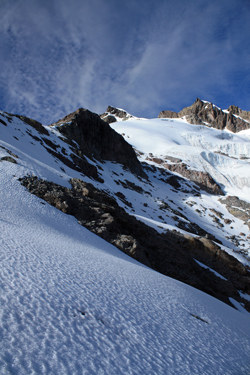
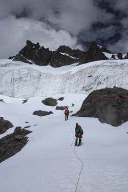
The pass did indeed provide perfect access to the flank of the mountain as well as offer a climber's trail that cut upward along the base of a ridge to the snow line proper. We climbed to the snow and then connected a few rock outcrops between sun hardened neve to a final rock stop that would serve as our jumping off point for the climb onto the glacier. We broke out the crampons, rope, harnesses, helmets and the like while Domingo and Rocque continued on up the rocky portion of the ridge, heading for a high observation point. This would be Bob's first time 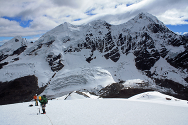 on a glacier, therefore he drew the middle position, I took the lead and G brought up the rear as the anchor man in the unlikely event of a crevasse fall. on a glacier, therefore he drew the middle position, I took the lead and G brought up the rear as the anchor man in the unlikely event of a crevasse fall.
We started off by crossing a moderate snow slope intersected by a rock rib or two before coming to a more substantial snow filled draw that would grant us access to the glacier proper. Bob quickly and easily fell into synch with the rope travel concept and within no time, we were all reading slack and tension without any problem. I zigged here and there to ascend the draw and kept my eye open for holes and crevasses . . . but there was nothing but solid neve under foot. At the top of the draw the terrain gave us a brief break and a rock outcrop onto which 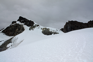 we all three could stand and consider the route from this point on. Our next stretch would be a zigging course up a steep 45 plus degree slope but I had an alternative plan. we all three could stand and consider the route from this point on. Our next stretch would be a zigging course up a steep 45 plus degree slope but I had an alternative plan.
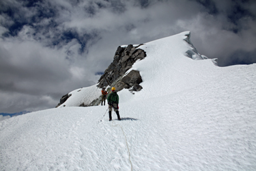
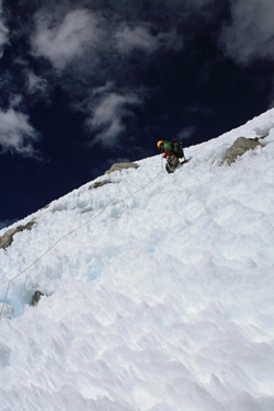
Rather than zigging, I took the slope straight on and, after a bit, I set a picket and ran the rope through the sling. It was now time for Bob to learn to pass through pro as we might need to place protection on our planned climb of Mariposa later in the trip. Needless to say, it was a quick lesson as Bob was already wired to the program and after another 2 pickets we crested the slope and came out onto a gently sloped terrain that lay below our next steep section. We took a brief break and demonstrated a pinwheel, wherein I retrieved the pickets for the next 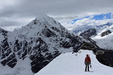 steep section, which was a shorter high wall that would land us on the small saddle that divides the two summits of the peak. We moved on and after zigging once around a snow filled crevasse, we were climbing to the saddle. steep section, which was a shorter high wall that would land us on the small saddle that divides the two summits of the peak. We moved on and after zigging once around a snow filled crevasse, we were climbing to the saddle.
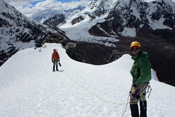
Once atop the saddle, we could see how corniced the opposite side of the peak was and I made sure to stay close to the side of the mountain that had provided our ascent route. Once everyone was atop the saddle, I took on the next slope, which started off at a moderate angle and then steepened again to about 45 degrees. The snow was solid neve but sun cupped enough that one would have to put some work into a fall, though a fall was definitely possible for the unwary. This slope, though 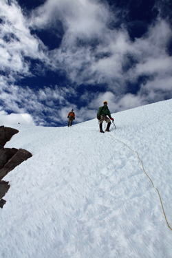 much shorter was similar to that of Pequeno Alpamayo, but not nearly as extended as the Bolivian version. As the slope lessened near the summit, we all stepped lively onto the summit flat that was a combination of neve on rock and very thick cornice. We put the packs down and took a look around, gaining an incredible view of he higher peaks to the north and south and the extended ice fields that filled the peak bound valley to the north. much shorter was similar to that of Pequeno Alpamayo, but not nearly as extended as the Bolivian version. As the slope lessened near the summit, we all stepped lively onto the summit flat that was a combination of neve on rock and very thick cornice. We put the packs down and took a look around, gaining an incredible view of he higher peaks to the north and south and the extended ice fields that filled the peak bound valley to the north.
We had had some less than perfect weather days before this climb but we were blessed with perfect weather on this summit day. We could clearly see the valley route we had taken to get to Pachaspata from Tinqui, one heck of a long two days walk in the distance. We could also see a portion of the large valley that we would later hike into after crossing Campa Pass and which would eventually take us three full days to descend in order to conclude our trek at Pitumarca. We did the usual summit photo thing and I got the chance to take photos of everyone this time, as I'd brought along a small tripod for the occasion.
 We spent a full half hour on the top and after making what has become the requisite gummy bear offering to Pachamama, we started the descent. Again, the drop was not steep enough to require protection but everyone did make an effort to firmly set their crampons and keep the axe at the ready for a belay if needed. We dropped from the summit proper and back onto the saddle dividing the two summits. As is the case on almost all of our glacier climbs, my photo taking was on the way down as I then have time to stop here and there, knowing the terrain and that we've scored the summit . . . time now allows the luxury . . . We spent a full half hour on the top and after making what has become the requisite gummy bear offering to Pachamama, we started the descent. Again, the drop was not steep enough to require protection but everyone did make an effort to firmly set their crampons and keep the axe at the ready for a belay if needed. We dropped from the summit proper and back onto the saddle dividing the two summits. As is the case on almost all of our glacier climbs, my photo taking was on the way down as I then have time to stop here and there, knowing the terrain and that we've scored the summit . . . time now allows the luxury . . .
 We maneuvered our way down to the flat below the saddle and then on down the remaining slope but with a hard turn down a glacier rib that would give us a descending traverse across the base of this side of the peak and deposit us at snow line about one half mile down the Campa Pass trail from the top. As we expected, the glacier was smooth and without substantive crevasse hazards as the snow season had ended only recently and the sun of the dry had not yet significantly weakened the snow bridges and caused the glacier to open up. We traversed the flank of the peak, steadily dropping until we reached the far side and could drop more directly to the edge of our terminal moraine. As we each arrived at the snow line, the rope was stacked and we dropped our packs and gear to take a break. We maneuvered our way down to the flat below the saddle and then on down the remaining slope but with a hard turn down a glacier rib that would give us a descending traverse across the base of this side of the peak and deposit us at snow line about one half mile down the Campa Pass trail from the top. As we expected, the glacier was smooth and without substantive crevasse hazards as the snow season had ended only recently and the sun of the dry had not yet significantly weakened the snow bridges and caused the glacier to open up. We traversed the flank of the peak, steadily dropping until we reached the far side and could drop more directly to the edge of our terminal moraine. As we each arrived at the snow line, the rope was stacked and we dropped our packs and gear to take a break.
 We soon packed the rope and tools of the trade and headed down the morainal rib to the trail below. We cut left and right here and there to connect patches of scree in lieu of talus and made the trail proper in about 20 minutes. From there is was just one foot in front of the other until we reached the crest atop the hill overlooking camp and the final descent. The crew wanted to know if we had made the top and we provided all of the details, including a run through some of the photos on the small screens of our various cameras. Domingo cooked up a mid afternoon snack and that evening's dinner couldn't have been better. We soon packed the rope and tools of the trade and headed down the morainal rib to the trail below. We cut left and right here and there to connect patches of scree in lieu of talus and made the trail proper in about 20 minutes. From there is was just one foot in front of the other until we reached the crest atop the hill overlooking camp and the final descent. The crew wanted to know if we had made the top and we provided all of the details, including a run through some of the photos on the small screens of our various cameras. Domingo cooked up a mid afternoon snack and that evening's dinner couldn't have been better.
Our next order of business was rest day before we took on what we figured would be the climb of the trip - Mariposa, a.k.a. Santa Catalina.
|
