Carbonate Mountain & Cyclone Mountain
North Ridge Variations - June 2, 2013
The forecast for the southern Sawatch called for Bicentennials with a touch of wind and lots of sun. We were out of Cheyenne by 5:15 on Saturday afternoon; the Xterra, loaded with three plus gear, was southbound and headed for a dinner of beef and chimichurri in Denver. We wanted Peruvian but the place we'd found in Wheat Ridge had closed so we moved to a new restaurant that offered a mix of Chilean and Argentine cuisine. With Andean food on board, we headed for the mountains.
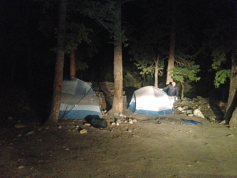 We're "dispersed" campers so we passed Angel of Shavano Campground in search of a pull off that would handle two tents in a relatively flat area. We scored a spot within the first mile and within a few minutes the tents were up and we agreed that the alarm would be set for 5 a.m. Our goal was to climb Carbonate and Cyclone, if Pachamama held us in her favor, make the long trip around the cirque to Grizzly Mountain. All too soon, the alarm went off and with but five hours of sleep, we hree had to push hard to get up and ready for the drive up to the Shavano town site trail head. We're "dispersed" campers so we passed Angel of Shavano Campground in search of a pull off that would handle two tents in a relatively flat area. We scored a spot within the first mile and within a few minutes the tents were up and we agreed that the alarm would be set for 5 a.m. Our goal was to climb Carbonate and Cyclone, if Pachamama held us in her favor, make the long trip around the cirque to Grizzly Mountain. All too soon, the alarm went off and with but five hours of sleep, we hree had to push hard to get up and ready for the drive up to the Shavano town site trail head.
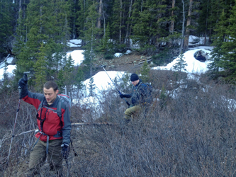 I missed the Cyclone Creek crossing and ended up at the hairpin about one half mile past the correct pullout. I turned around and soon enough we were parked at the wrong pull off and getting our gear ready to go. We locked up the truck and I led the way into the woods on a fairly obvious trail that petered out within a just a hundred yards or so. The woods were open, with little under story, and there was a small creek so we were at least walking in the right direction . . . uphill. We went about a quarter mile before stopping to consult with the map and then cut 45 degrees right to intercept Cyclone Creek. We went another quarter mile up and sometimes down before coming to the drop off that marked our arrival at the correct creek. I missed the Cyclone Creek crossing and ended up at the hairpin about one half mile past the correct pullout. I turned around and soon enough we were parked at the wrong pull off and getting our gear ready to go. We locked up the truck and I led the way into the woods on a fairly obvious trail that petered out within a just a hundred yards or so. The woods were open, with little under story, and there was a small creek so we were at least walking in the right direction . . . uphill. We went about a quarter mile before stopping to consult with the map and then cut 45 degrees right to intercept Cyclone Creek. We went another quarter mile up and sometimes down before coming to the drop off that marked our arrival at the correct creek.
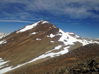
 I've read multiple narratives for this route, meaning the right route and not our version, hence I was figuring to cut a trail on one side of the creek or the other. We skirted the steep creek bank until it mellowed a bit and gave us reason to drop down . . . believe it or not . . . right at the trail crossing. We followed segments, damn few unfortunately, that were not covered by the numerous snow hummocks that were still hanging on in the darker parts of the woods. Thinking "light" with every hummock we crossed, we worked our way upstream for another quarter mile or so, hoping to break out of the woods, before we came to a break in the trees that gave us a good view of the long curving South Ridge of Carbonate Mountain. We saw what looked like the promise of a snow line, perhaps even a continuous line, so we opted to quit the woods and find a way across the creek. I've read multiple narratives for this route, meaning the right route and not our version, hence I was figuring to cut a trail on one side of the creek or the other. We skirted the steep creek bank until it mellowed a bit and gave us reason to drop down . . . believe it or not . . . right at the trail crossing. We followed segments, damn few unfortunately, that were not covered by the numerous snow hummocks that were still hanging on in the darker parts of the woods. Thinking "light" with every hummock we crossed, we worked our way upstream for another quarter mile or so, hoping to break out of the woods, before we came to a break in the trees that gave us a good view of the long curving South Ridge of Carbonate Mountain. We saw what looked like the promise of a snow line, perhaps even a continuous line, so we opted to quit the woods and find a way across the creek.
 The creek at this point is not that wide but both banks were grassy and coated with ice from the chill of the night before. Every narrow spot promised little more than a soaked foot, an option none of us wanted to go for. Instead we dragged a six inch downed pine and tossed it across as a sure intermediate step to get us across. We all made it over, feet dry, and pushed through willows for 75 feet or so to the foot of a talus slope that would grant us access to the promise of a snow filled gully. We gained perhaps 250 feet of elevation before the start of the snow and . . . Calvin's first experience on crampons with ice axe in hand. The creek at this point is not that wide but both banks were grassy and coated with ice from the chill of the night before. Every narrow spot promised little more than a soaked foot, an option none of us wanted to go for. Instead we dragged a six inch downed pine and tossed it across as a sure intermediate step to get us across. We all made it over, feet dry, and pushed through willows for 75 feet or so to the foot of a talus slope that would grant us access to the promise of a snow filled gully. We gained perhaps 250 feet of elevation before the start of the snow and . . . Calvin's first experience on crampons with ice axe in hand.
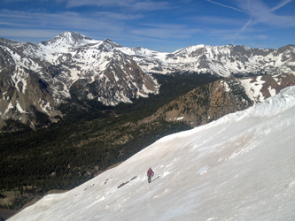
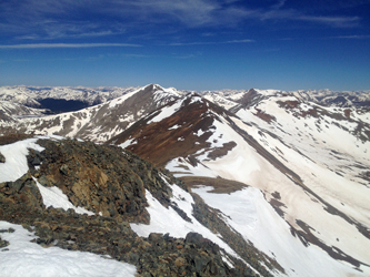 The snow was of the summer sun baked variety, perfect for crampons, like walking on styrofoam. I coached Calvin on the crampons and then G gave him a brief snow school as to the operation of the ice axe. He took to it like a fish to water and then we moved on up slope, left . . . right . . . traversing our way to about the 12,750 mark before we topped out and dropped the crampons and axe for bare boots and hiking poles. The slope mellowed and we made our way to the ridge line proper, which in turn extracted another 600 feet of vertical from us before we arrived at the summit. The snow was of the summer sun baked variety, perfect for crampons, like walking on styrofoam. I coached Calvin on the crampons and then G gave him a brief snow school as to the operation of the ice axe. He took to it like a fish to water and then we moved on up slope, left . . . right . . . traversing our way to about the 12,750 mark before we topped out and dropped the crampons and axe for bare boots and hiking poles. The slope mellowed and we made our way to the ridge line proper, which in turn extracted another 600 feet of vertical from us before we arrived at the summit.
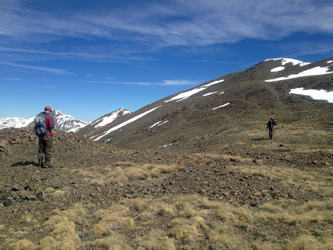
 We took a short break, but not too long, as the wind had picked up and we really did not want to have to add and then drop an extra layer just for the break. Two minutes at the most saw us on our way down the far side to the saddle connecting Carbonate and Cyclone Mountains. The terrain was strictly class 1 territory and we made short work of the descent to the connection between the two peaks. The ascent up Cyclone was softened by a long snowfield that offered a gentle snow route for one half of the distance to the summit. The snow was now taking a shallow track as the sun had been on it for a couple hours. Once off the snow, we needed only hike on up through a couple of talus covered slopes to arrive at our second summit of the day. We took a short break, but not too long, as the wind had picked up and we really did not want to have to add and then drop an extra layer just for the break. Two minutes at the most saw us on our way down the far side to the saddle connecting Carbonate and Cyclone Mountains. The terrain was strictly class 1 territory and we made short work of the descent to the connection between the two peaks. The ascent up Cyclone was softened by a long snowfield that offered a gentle snow route for one half of the distance to the summit. The snow was now taking a shallow track as the sun had been on it for a couple hours. Once off the snow, we needed only hike on up through a couple of talus covered slopes to arrive at our second summit of the day.
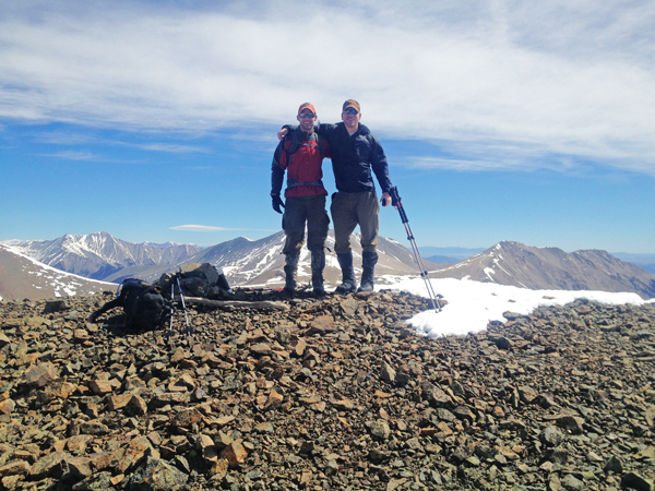
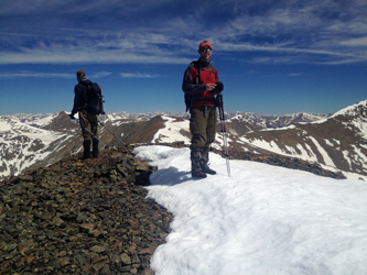 For me, this was more than the second summit, it was my 100th distinct 13'er since starting on this venture in 1998. We took in the sights, much snow to the north and far less to the south. We did want to grab a bite as it was now 11:30 and we had to decide if we would make the trek to Grizzly Mountain, well beyond a mile distant via the connecting ridge. We found shelter from the wind just off the summit and after finishing off Girl Scout cookies and pepperoni whose packaging had a use by date back in early late 2011, we had only to decide whether to go on to Grizzly or make our way down. With the warmth of extra layers and our hunger satisfied, we looked at the ridge and popped our heads up into the wind, now blowing at a steady 20 to 25 mph and easily gusting to 35 or 40 mph . . . and decided two summits were sufficient for today. For me, this was more than the second summit, it was my 100th distinct 13'er since starting on this venture in 1998. We took in the sights, much snow to the north and far less to the south. We did want to grab a bite as it was now 11:30 and we had to decide if we would make the trek to Grizzly Mountain, well beyond a mile distant via the connecting ridge. We found shelter from the wind just off the summit and after finishing off Girl Scout cookies and pepperoni whose packaging had a use by date back in early late 2011, we had only to decide whether to go on to Grizzly or make our way down. With the warmth of extra layers and our hunger satisfied, we looked at the ridge and popped our heads up into the wind, now blowing at a steady 20 to 25 mph and easily gusting to 35 or 40 mph . . . and decided two summits were sufficient for today.
Sure we could have done it, I mean come on, it was sunny and June, but we could also wander our way on down and make it home before midnight, including a decent burger on the way. Decision made, we set sights on food and headed for the truck.
|
