|
|---|
South Arapaho PeakNovember 22, 2008 - Southeast Ridge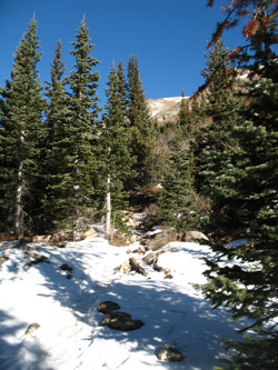
No alpine start, the trip to the trailhead would only be two hours or so, if the road was open . . . as the start of the climb up South Arapaho is the terminus of the road leading to the Fourth of July Pass trailhead. It was mid November and by all rights the road should be snowed in for the winter. But this had been a dry year so far and the road mostly traverses the south facing side of the valley. Just one week before, I drove to the summer 4wd trailhead for Mount Elbert and I had a hunch this road might also be open. If not, there was always the option of the American Alpine Club's new museum in Golden.
We hefted the packs and walked to the trailhead to start the climb. The first leg of the trail is the developed path to Fourth of July Pass, three miles distant. We were not going all the way to the pass but only to the Fourth of July mine, I was back up and walking by the time G turned the corner and we hiked on up to the old mine site. The whole of the trail was icy or snowy, even where the trail broke from the trees and skirted the side of the hill, working its way up to the pass. The mine really is little more than a muck pile and some equipment remnants but it marked our turn off toward the peak proper. The trail we now The formal route to the saddle is a winding path but this was a winter climb so we made a straight line course for the saddle, at least as straight as one can get when climbing over alternativng patches of grass and talus. The ground was hard frozen and I followed the steps of a solo climber who had taken the same path a day or so earlier. The climb to the saddle is long, I figure about 1500 vertical feet thought it does not look that high from the bottom. Trust me, climb to the top and you will buy into every one of those 1500 feet. The From the crest, I stuck with the path of climbers before me and made it to what I thought was the summit. Again, a false high point as this was but a sub summit separated from the true summit by a short drop and additional climb to the actual summit. The rocks were now all coated with wind blown snow, the frozen fingers of which were extending from the rock by the action of We did not stay on the summit long but ate a few ceremonial gummy worms, left one for Pachamama, and took to our feet to descend. We tracked back over the subsidiary summit and back down the ridge proper to arrive at the top of the saddle, about 700 vertical feet below. The footing was not bad but the winds were making for some
|

 We gave no thought to an alpine start and left Cheyenne at a bit after 6 a.m. The trip to Nederland took a bit under two hours and then we had only to negotiate the 5 mile dirt road to the trailhead. The road was open all the way and even though there were some shaded zones, there were no spots that required four wheel drive for my Tacoma truck. We parked at the trailhead lot and slowly got our gear together . . . as the wind was blowing up the valley at a good clip. This was clearly contrary to the forecast of 10 to 15 mph winds with some gusts to 30 in the afternoon. There was no doubt, it was going to be a windy day and I left the car with the pit zips zipped and the balaclava on over my ball cap.
 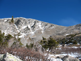 located at about the two mile mark. The trail led through the woods and as one might expect it was a bit icy. Actually, it was a lot icy and everywhere there was a flow of water down the trial, it was a swath of ice. I did not bring my crampons but I should have, as after about one mile, I ended up on my ass with my thumb well twisted in the strap of my flailing hiking pole. Ouch!
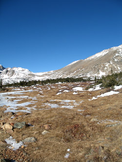
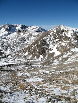 wanted was the route to the Arapaho Saddle and we could see a few segments, but not many, as the path left the mine site to climb to the saddle, suprisingly high above. We made our way through 12 inch deep snow and across hard patches until we reached a huge boulder the provided some break from the wind that was now howling up the route we needed to climb. We each shot a Goo, took a sip, and I swapped my fleece gloves for my heavy winter expedition gloves as the cold shafts of the hiking poles were chilling my hands badly.
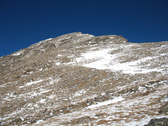 top actually is not the top as the saddle we were climbing to was, in fact, a false saddle. But no matter as we cut to the left to take a glancing route to what we thought was the summit. We climbed on and crossed a few snow fields before taking to the scree and increasingly larger talus to reach the crest of the ridge perhaps 400 feet above the true high point of the saddle, now a ways off in the distance.
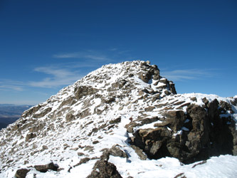 the wind. The temperature was not that bad, albeit below freezing, but the wind was now blowing at 30 mph and likely gusting as high as 50. Not quite blow you down but the hiking poles were really handy as we hopped from rock to rock through the wind gusts. I paused so G could catch up and we climbed to the icebound true summit, arriving at about 12:30, about 3 1/2 hours after our departure from the truck.
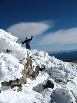 very cold hands and a good push here and there, generally at the moment I chose to hop from one rock to another. From the saddle we reversed the route of our ascent and made good time back down to the large boulder where we again stopped to hydrate and eat a bit, before crossing the last bit of open country before the two mile ice trail to the parking lot. The wind was less strong in the valley and the temperature was warm enough to let the mud and ice along the trail enough that the entirety of the descent was not a continuous slide. We made the two mile trip without falls and placed the summit of South Arapaho Peak in the winter climbing bag.