North Star Mountain
December 19, 2009 - East Ridge from Hoosier Pass
It was nine degrees when we left Cheyenne and that should have been an indicator of what we would experience on our climb of North Star Mountain. Of course, one can always hope for an inversion and balmy temperatures up high in the middle of December . . . right? It took us a bit over 3 hours to get to the parking area on Hoosier Pass and another 15 minutes to swap boots and brace ourselves for the day's climb. The air was still and the weather forecast was calling for a bluebird day. We were still working toward getting ready for an upcoming Argentina trip, so the prospect of a 2000 foot climb to a bumpy 13k+ ridge was just what we were looking for.
 We had a copy of Dave Cooper's Colorado snow climbing guide, which notes a number of routes for this peak. We debated whether to stick to the old mining road and possibly having to deal with an avi slope or just cut up and over the ski/sled hill that lies just beyond the start of the trail. We knew the avi forecast was calling for a mix of moderate and considerable avalanche potential but we stuck with the road, figuring to scope out the one avi zone and possibly avoid an early climb to the ridge. The route is obvious once you leave the parking area, we went straight ahead for a few hundred yards and cut left on the old road to skirt around the base of the sled hill, through sparse trees for a quarter mile or so before cutting We had a copy of Dave Cooper's Colorado snow climbing guide, which notes a number of routes for this peak. We debated whether to stick to the old mining road and possibly having to deal with an avi slope or just cut up and over the ski/sled hill that lies just beyond the start of the trail. We knew the avi forecast was calling for a mix of moderate and considerable avalanche potential but we stuck with the road, figuring to scope out the one avi zone and possibly avoid an early climb to the ridge. The route is obvious once you leave the parking area, we went straight ahead for a few hundred yards and cut left on the old road to skirt around the base of the sled hill, through sparse trees for a quarter mile or so before cutting 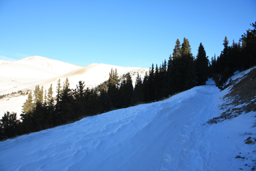 back toward the base of the mountain. There was no doubt that it was cold . . . I'd started out with a balaclava on as well as my heavy mittens and the cold was cutting through the layers with brutal efficiency. back toward the base of the mountain. There was no doubt that it was cold . . . I'd started out with a balaclava on as well as my heavy mittens and the cold was cutting through the layers with brutal efficiency.
I would like to say that we had opted to leave our snow shoes home on the basis that we figured the majority of the route would be wind blown but the real reason we did not elect to shoe this stretch was that we simply forgot to put the shoes in the back of the truck . . . in Cheyenne. We only have 250+ 14'ers and 13'er between us so this oversight came very easily to the two of us at 4 a.m. I'm almost 50 and I still bound out of bed in the name of the alpine start but the odds of me getting all my gear 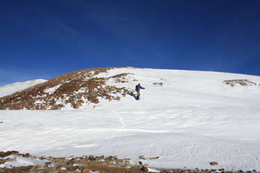 into the car seems to be faltering . . . maybe time for the checklist that I used to use when I was 20 years younger? Regardless we trod along the road through snow that was tracked by a fellow, using snow shoes, somewhere ahead of us, an earlier departure that proved to be quite convenient. into the car seems to be faltering . . . maybe time for the checklist that I used to use when I was 20 years younger? Regardless we trod along the road through snow that was tracked by a fellow, using snow shoes, somewhere ahead of us, an earlier departure that proved to be quite convenient.
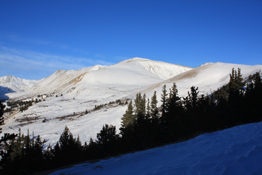
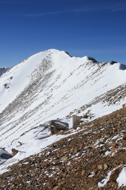
We cut around the sled hill and could see the summit of North Star Mountain way off in the distance at the far end of the valley that separates it from the northern flanks of Lincoln and Democrat. The snow on the road was wind scalloped here and there and in places the wind had cut the snow along the edge all the way to bare ground. I made for those brown patches like a bee to a flower, as we trod on to the 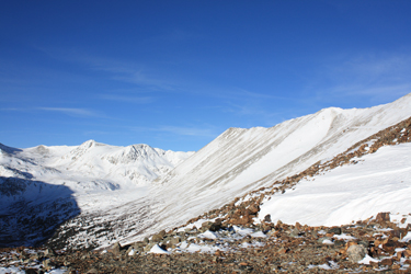 substantive part of the climb . . . the slope that would put us on the ridge proper. We also managed to avoid the avalanche slope detour as the base of the slope that had the most potential to move was the one stretch of the road that was cut to bare dirt for the whole of the starting zone. Now that was easy . . . substantive part of the climb . . . the slope that would put us on the ridge proper. We also managed to avoid the avalanche slope detour as the base of the slope that had the most potential to move was the one stretch of the road that was cut to bare dirt for the whole of the starting zone. Now that was easy . . .
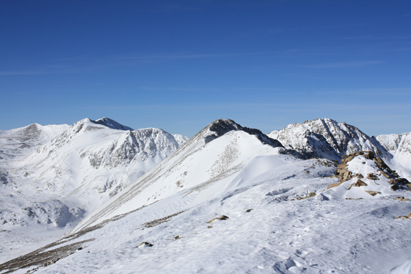
We stuck to the road and passed the first of multiple mine ruins before cutting around a pipe gate and cutting a diagonal course to intercept the ridge that appeared to have some bare spots along the crest. We'd given up the snowshoe track as a path could be found connecting wind hammered patches that obviated the hassle of post holing between rocky patches. We'd knocked off the first part of the climb 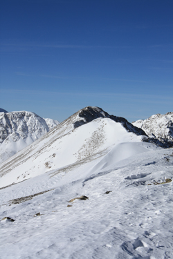 and now needed only to climb to the first of the 13,000+ foot bumps on the ridge. We found hard snow to climb and then intercepted a strong miner's trail that zig zagged up to the first ridge bump proper. The Cooper guide notes that the distance to the far summit is well onto a mile and half and with the wind that we were getting knocked about by, we knew that it would be a long hike along this ridge.The course along the ridge from the first bump covered scalloped snow and a patch of rock here and there. There are a few ups and downs but we covered the ground in pretty good time. The challenging portion of the route came at the close of the first bump segment where there is a saddle and the second false summit or bump. This portion of the ridge had a snow ridge, not quite a knife edge but about 2 feet wide with class 2+ terrain to the right and a snow slope falling off to the south. The fellow ahead of us had obviously dispensed with the snow shoes by this point and was setting a good boot track along the ridge. We spotted him ahead and noted that we were likely to catch up with him in the next quarter mile or so, thereafter we'd be the ones setting the track. and now needed only to climb to the first of the 13,000+ foot bumps on the ridge. We found hard snow to climb and then intercepted a strong miner's trail that zig zagged up to the first ridge bump proper. The Cooper guide notes that the distance to the far summit is well onto a mile and half and with the wind that we were getting knocked about by, we knew that it would be a long hike along this ridge.The course along the ridge from the first bump covered scalloped snow and a patch of rock here and there. There are a few ups and downs but we covered the ground in pretty good time. The challenging portion of the route came at the close of the first bump segment where there is a saddle and the second false summit or bump. This portion of the ridge had a snow ridge, not quite a knife edge but about 2 feet wide with class 2+ terrain to the right and a snow slope falling off to the south. The fellow ahead of us had obviously dispensed with the snow shoes by this point and was setting a good boot track along the ridge. We spotted him ahead and noted that we were likely to catch up with him in the next quarter mile or so, thereafter we'd be the ones setting the track.
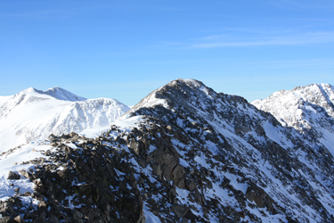 The traverse up and over the second false summit is much more entertaining than the first and gives a couple of heel stepping patches of snow to skirt short steep sections before depositing you at the saddle that separates this segment from the final climb to the summit. But even at this point, you are not that close to the summit, at least on a winter climb. At this point the wind that had been taunting us from about the 13k mark and then along the whole of the ridge was really blowing. The gusts were easily hitting 30 mph and the rare still periods between the gusts were highlighted by watching snow devils play along the flank of the peak, foretelling the next biting gust to hit. The forecast temps just weren't making an appearance The traverse up and over the second false summit is much more entertaining than the first and gives a couple of heel stepping patches of snow to skirt short steep sections before depositing you at the saddle that separates this segment from the final climb to the summit. But even at this point, you are not that close to the summit, at least on a winter climb. At this point the wind that had been taunting us from about the 13k mark and then along the whole of the ridge was really blowing. The gusts were easily hitting 30 mph and the rare still periods between the gusts were highlighted by watching snow devils play along the flank of the peak, foretelling the next biting gust to hit. The forecast temps just weren't making an appearance 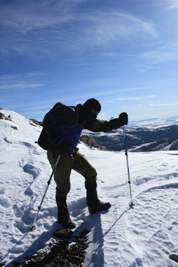 and the strength of the wind was such that even the unobstructed sun provided little warmth to counter act the stinging nose and the freezing cheeks. and the strength of the wind was such that even the unobstructed sun provided little warmth to counter act the stinging nose and the freezing cheeks.
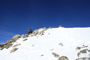
We trudged our way up the final stretch of ridge, now setting the track as we'd passed the other fellow at the descent to the last saddle. The course to the summit sticks to the ridge but for a cut around here and there to avoid ground that, when covered with snow, really does not need to be crossed when there is a more surefooted path available. We compartmentalized the wind and the cold and trudged along to the summit, stopping only long enough o spot a sheltered rocky area perhaps 25 feet lower on the northern slope, a spot that held out some promise of a break from the wind. We found a spot to sit for a few minutes to eat a handful of trail mix, shoot a Gu and chug a few ounces of water. We both added a down layer and wasted no time in getting ready to set off from the summit.
 We started our down climb, electing to keep the down layers on as the wind had strengthened enough to blow one to the ground but for the hiking poles he were using. The walk to the saddle separating the summit hump from the mid ridge hump was one of those turn your head from the wind and walk with the upwind eye closed to avoid the sting of the cold stretches. I'd also taken off my mitts when we ate and substituted glove liners for no more than 2 minutes and I had to pay the price. I got the circulation going again after about ten minutes and then that incredible pain that aches all the way up to the elbows set in, that hurt that just about makes you cry but for the fact that you know that warm hands follow the hurt. By the saddle, we'd both warmed up. We started our down climb, electing to keep the down layers on as the wind had strengthened enough to blow one to the ground but for the hiking poles he were using. The walk to the saddle separating the summit hump from the mid ridge hump was one of those turn your head from the wind and walk with the upwind eye closed to avoid the sting of the cold stretches. I'd also taken off my mitts when we ate and substituted glove liners for no more than 2 minutes and I had to pay the price. I got the circulation going again after about ten minutes and then that incredible pain that aches all the way up to the elbows set in, that hurt that just about makes you cry but for the fact that you know that warm hands follow the hurt. By the saddle, we'd both warmed up.
 The wind seemed to be at its worst on the summit hump but we took a few more good hits as we traversed the second hump. However, when you have your eye set on a miner's track that will take you to lower ground, the tough parts just seem to pass with less pain. We dropped off the ridge at the second saddle, passed a scattering of mine ruins and cut east to drop off the ridge proper. The lower elevations were sheltered from the wind and within a few minutes the down layers were back in the packs and we were making good time connecting patches of scree with snow to drop in elevation back to the mine road just above the pole gate. From there we needed only to follow the road, albeit again through the snow that a few day trippers had now cut up during the course of the day. Regardless we were soon skirting the base of the sled hill and then turning toward the parking area on the pass. By the time we got to the truck, the wind was gone, the cold had abated and life was good again, certainly much better than the conditions that likely still existed on the ridge more than two thousand feet higher than the warm tailgate of the truck that we sat on as we changed clothes in the warmth of the sun. The wind seemed to be at its worst on the summit hump but we took a few more good hits as we traversed the second hump. However, when you have your eye set on a miner's track that will take you to lower ground, the tough parts just seem to pass with less pain. We dropped off the ridge at the second saddle, passed a scattering of mine ruins and cut east to drop off the ridge proper. The lower elevations were sheltered from the wind and within a few minutes the down layers were back in the packs and we were making good time connecting patches of scree with snow to drop in elevation back to the mine road just above the pole gate. From there we needed only to follow the road, albeit again through the snow that a few day trippers had now cut up during the course of the day. Regardless we were soon skirting the base of the sled hill and then turning toward the parking area on the pass. By the time we got to the truck, the wind was gone, the cold had abated and life was good again, certainly much better than the conditions that likely still existed on the ridge more than two thousand feet higher than the warm tailgate of the truck that we sat on as we changed clothes in the warmth of the sun.
The other side of Hoosier Pass? Mt. Silverheels in the winter
|
