|
||||||||||||||||||||
|---|---|---|---|---|---|---|---|---|---|---|---|---|---|---|---|---|---|---|---|---|
Banff Assiniboine Expedition IAugust 8, 2002 – Mount Athabasca under sunny skies
If everything is going your way, the start of the climb up Mount Athabasca will begin at the climber’s car park about one mile up the “snow coach road” instead of the lower parking area, just across form the Icefields Center. The snow coach road is closed to traffic during the day (~9 a.m. to 7 p.m.) by a gate but the road should be open and the upper parking area available outside of those hours.
The park ranger advised us that the gate would be open in the early morning hours so we postponed our alpine start from 4 o’clock to 5 a.m. as the open road would cut a mile off the front and back ends of the climb. With this advantage, we arrived at the gate, closed of course, at 4:45 and chatted briefly with a pair of climbers who were equally happy with the opportunity to add two miles to their climb. We sighed, shrugged our shoulders, and hoisted our packs for the extra hike to the climber’s park. From the upper pulloff, the trail meanders up the ridge of a lateral moraine for a mile or so before reaching a headwall adjacent to the toe of the Boundary Glacier. The trail then braids to a number of loose scree filled routes up the headwall, none of which seemed any better than another. We took the most direct route and fought our way up loose scree, talus, and ledges to gain the upper portion of the moraine. The remaining trail resumes its course on the crest of the moraine for another half mile before ending at a patch of snow that provided a low angle entry onto the glacier proper.
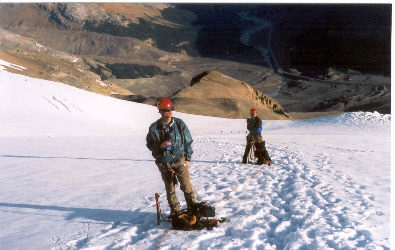
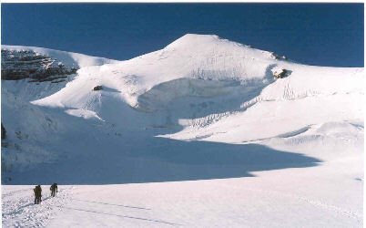
We stopped and geared up in the company of a large guided group, as in about 16 clients, and a few other 2 person private parties. I took the lead and Gary the sweep as we checked our gear, tied Kiwi coils, and hustled to stay at least a few minutes ahead of the masses. Unfortunately, for me, the day was not going well and the 20-minute stop to gear up was the practical end of my day. I led onto the snow and we meandered along, following the tracks of previous day’s parties and traversing in a long sweeping turn toward steeper snow and a crossing below an upper icefield crowded with seracs. We knew from the available route description that there was a danger of serac fall and that the portion of the trail crossing below the fall line would need to be traversed with speed. That was something I had little to give.
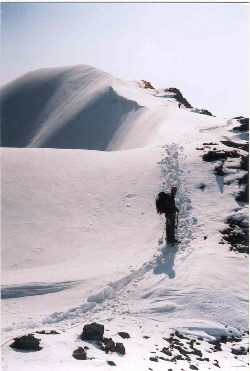
Gary observed that our pace sucked (a high tech climbing term) and came forward to suggest that he lead and that I fall back to the rear, a suggestion that I accepted without question. We continued and made the crossing below the seracs without incident and then dropped the pace to a slower routine that I was more comfortable with. We completed the traverse across the remaining face of Athabasca and climbed up to the northern shoulder of the peak, crossing some obvious crevasses enroute. Once the north ridge was reached, we were on rock instead of snow and I started feeling better. We pulled in our lines and moved in a closer grouping up the rocky switchback trail leading to the summit ridge. The summit ridge proper is a wonderful rolling crest with rock to the west side and snow to the east. We rose and fell as we walked the ridge to the summit proper, which was just a high point on long icy ridge.
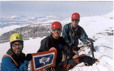
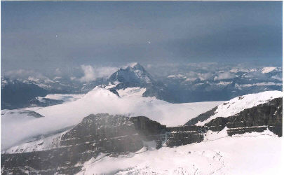
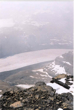
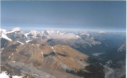
We swapped small talk with another group just coming off the summit and then stepped to the ridge for photos and views of the surrounding mountains and the glaciers filling the valleys far below. We did not stay long as the clouds were starting to push north from the Banff area and the snow was starting to get mushy, increasing the danger of problems below the seracs about half way back down the peak. We headed on back down the ridge, dropped quickly through the rock trail section and let out our coils for the glacier travel portion of the descent. The traverse below the seracs went smoothly and soon enough we were on the flats far below them and able to stop for a drink and shot of Goo. From there, it was just a rolling walk to the edge of the moraine and on back down the trail to the climber’s park.
We hoofed it on back to the car and went on over to the Icefields Center to let the rangers know we were off the peak. We also were scoping out a route for the next day, specifically the Skyladder route on Mount Andromeda, however the rangers indicated that the line we were interested in had avalanched the previous evening, exposing the under layer of hard ice where climbable snow might have been. With that route out of the question and others on surrounding peaks being in “poor condition,” we needed a new plan. South of the Icefields lay the Presidents and Mount Hector, both Class I peaks that even with ice, could be expected to be within the range of our ability.
We were fortunate to score a day on Athabasca that gave us a sunny climb in the middle of a period of wet and rainy weather. Our time for the climb was fast in spite of my meltdown on the ascent, about 7-1/2 hours. As I said earlier, every peak turned into a learning experience and Athabasca was no exception. Lessons learned on our second climb were:
Since we arrived back at camp by mid afternoon, there was plenty of time to go to the Icefields Center and play tourist. The visitor’s area has a good explanation of the Icefields and glaciers in general as well as serving the commercial needs of the tourist operation on the Athabasca Glacier. We took in the exhibits and killed time until 7 p.m. when the better of the two restaurants opened; meaning someone outside of our group would do the cooking that evening. We had a good dinner, sampled some more of the Canadian brews and then went out for a walk to the toe of the Athabasca Glacier itself. Given the latitude of the Icefields, we had light until 10 in the evening and since the next day was a rest day, none of us was in a hurry to head back to the campground. August 9, 2002 – Rest Day at Emerald Lake and the Spiral Tunnels
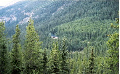
Our rest day plan was now based on a climb of either Mount Hector or the Presidents the following day, necessitating relocation back to the vicinity of Lake Louise. We headed south on the Icefields Parkway to scope out Mount Hector, which is only partially visible from the road, and located the unmarked trailhead. We next took the trans Canada to the vicinity of Field, British Columbia with a stop at the Spiral Tunnel Viewpoint. During the construction of their transcontinental railway, the Canadian Pacific Railroad was faced with steep grades, which they countered by driving two spiral tunnels that allow a train to enter the tunnel and cross over itself in the process of climbing or descending the grade. If one times the stop correctly, a freight train will come by but we did not stick around the tunnel viewpoint for long because, to quote Cousin Eddie, “the shitters were full” and the air had a distinct aroma.
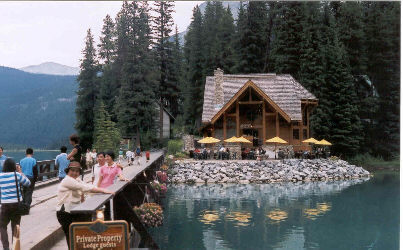
Just beyond Field, we took the turnoff to Emerald Lake, a beautiful alpine lake in Yoho National Park. The lake is a touristy spot but we figured it was a rest day and we could take in a sight or two just like any other traveler. We were also hungry so we had lunch at the restaurant next to the Emerald Lake Lodge and scoped out the approach to the Presidents. These two peaks, connected by a shallow col, may be approached from either side but the Emerald Lake route is more practical and can be done in a “full” day. We scoped out the topo map and looked at the route with binoculars from the Lake access road, but we finally settled on Hector in lieu of the Presidents after a stop at the Yoho Park Visitor Center and a call to the Park safety warden. He suggested that the President’s glacier bergshrund would be more than a bit challenging at this time of year but also that Mount Hector would be seriously crevassed. Six in one hand, half a dozen in the other . . . since Hector was closer to our camp at Lake Louise, Mount Hector it would be.
|
