|
||||||||||||
|---|---|---|---|---|---|---|---|---|---|---|---|---|
Mount MeekerMay 9, 2004 - Dragon’s Egg Couloir - Snow
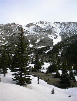
Meeker had been on the list for a year, but in lieu of taking the popular Loft Route we selected the less traveled Dragon’s Tail Couloir. The route provides over 3000 vertical feet of snow to climb, with the caveat that one must complete the south facing route before the sun makes the descent a living hell of post holes replete with worries of sliding slush. We pulled it off, barely. We left Cheyenne at midnight and arrived at the Copeland Lake trailhead a bit after 2 a.m. The temperature was just incredible, 45 degrees in the middle of the night! We put on the double plastic boots, made sure we had our specs and headed up the trail for Sandbeach Lake, hoping with every step that the snow line was high enough to keep those snowshoes securely lashed to our packs. It worked that way for the first two miles but soon after we were on the shoes to the base of the couloir.
The route to the Dragon’s Tail is pretty straightforward until you reach the last mile or so. The main trail was easy to follow for the most part until the crossing of Hunter Creek. After the creek, the snow was deeper and the trail segments that earlier made route finding easy now disappeared. We followed the tree cut but as we neared Sandbeach Lake, we lost the trail for the last time. But that was OK as our plan was to go up valley until we could glimpse the base of the couloir off to the north . . . then we would bushwhack over to the climb. We could have bushwhacked along Hunter Creek from the crossing but given the amount of snow; we chose to use as much trail as possible. In hindsight, our approach was perfect.
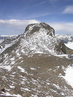
The couloir is simple to spot, it is a wide undulating route up the south flank of Mount Meeker with a big rock about one third of the way up. The views we had seen before the climb were typically foreshortened and the angle of the climb looked mild after the first couple of hundred feet. The looks turned out to be a bit deceiving. We dropped our snowshoes at the base as we had decided that we would not be returning via the Meeker Ridge and we did not want to lug the extra weight up 3500 feet of climb to the summit. We also dropped our water pump after filling our now dry quart bottles and another one each for the climb. We figured from the start that with the high temps called for, we would have water to pump and that a one-quart approach would get us to the base where we could pump more for the hike to the top.
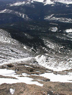
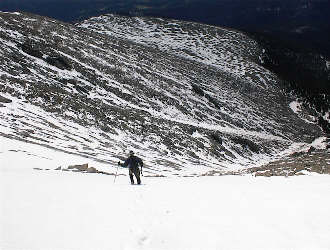
We scrambled up to the base of the couloir and put on the crampons for what would prove to be a long crampon cruise. It was now 7 a.m. and we were blessed with an overcast sky. The snow was crisp, taking the full bite of the crampon but no more. We climbed steadily, switching back and forth, crossing one another’s paths as we both sought the best combination of rest step and preferred angle of climb. The Dragon’s Egg proved to be about 1/3 of the way up and after passing it; we found the snow steeper than it appeared from below. I would estimate that while the bulk of the climb is at about 40 degrees, there are sections that likely rise to about 50. The climb was not particularly hard but the vertical relief becomes obvious as one climbs and assesses the growing importance of a prompt arrest in the event of a snagged crampon or other innocent misstep.
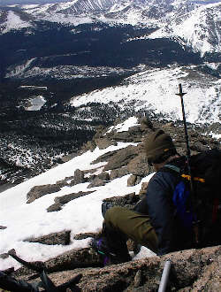
We intersected Meeker’s south ridge at about 13,500 feet and dropped the axes and crampons for the ridge walk to the summit. The slope to the top was mild and afforded great views of Pagoda, Chief’s Head and Longs Peak. We arrived at the summit at 10 a.m., having been on the move for 7½ hours. The winds picked up for our arrival and we spent but seconds on the high point before dropping off to the north to find shelter for a rest and re-hydration stop. We soon had our fill and headed back down the ridge to get the snow gear and make our descent to the valley far below. The snow was softening fast and we really did not want to have to scramble down a ridge in lieu of plunge stepping down the couloir at a much better pace.
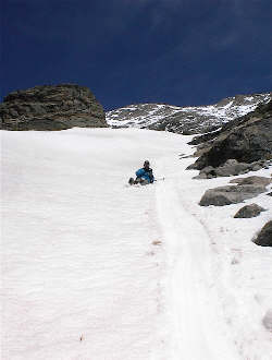
The upper couloir was still in good shape but by the time we were 1/3 of the way down, we were starting to post hole. Onto the butt was the next move and with the exception of a few walking detours around short drops, we slid the length of the lower 2/3 of the couloir. Not soon enough, we were back at the snowshoes, eating another quick snack and packing up to bushwhack our way out along Hunter Creek. We knew that a path parallel to the water would likely be the best way out and that a summer trail did take this route. However, the snow depth made paralleling the creek a challenge in places. We slogged on down past the falls noted on the map and eventually stopped to shake our heads at the distance and wonder why we had not yet intersected the trail. We compared map and compass and voiced the classic line . . . “ the trail has to be right around the bend.” You know what? It was. Our trip out on the trail proper included a stop or two to drink but mostly we were thinking about the Grumpy Gringo in Estes. We made the truck at a bit after 3 p.m. with Meeker in hand via one very long snow climb.
|
