-
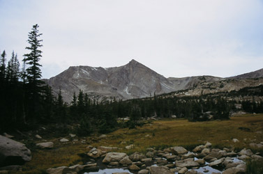
Mt. Bierstadt Group Summit - Front Range, Colorado
-
A rest before the summit push on Dallas Peak - San Juan Range, Colorado
-
Broken Ankle + 6 Miles = Tired
-
The classic San Juan approach - San Juan Range, Colorado
-
Overlooking Noname Basin from Twin Thumbs Pass - San Juan Range, Colorado
-
Upper Noname Basin - San Juan Range, Colorado
-
Nearing Noname Cabin - San Juan Range, Colorado
-
Twin Thumbs Twins - San Juan Range, Colorado
-
Nearing the summit of Pt. 13,736 - Sawatch Range, Colorado
-
Blustery day on Iowa Peak - Sawatch Range, Colorado
-
Morning snow at 15k, Cerro Ramada - Cordillera Ramada
-
Artesonraju from the summit of Nevado Pisco - Cordillera Blanca, Peru
-
February crowds on Gray's Peak - Front Range, Colorado
-
Kicking steps on Cerro Lliani - Cordillera Vilcanota, Peru
-
Final traverse to the summit of Wheeler Mountain - Ten Mile Range, Colorado
-
The long walk to Pachanta - Cordillera Vilcanota, Peru
- banner31
Afternoon at 17k on Cerro Ramada - Cordillera Ramada, Argentina
- banner22
The final ridge on Iowa Peak - Sawatch Range, Colorado
-
Summer summit on Longs Peak - Front Range, Colorado
-
A rest day at the Pachanta Hot Springs - Cordillera Vilcanota, Peru
-
Mind over matter on Mt. Parnassas - Front Range, Colorado
-
Rest stop on Cerro Lliani - Cordillera Vilcanota, Peru
- banner30
Post nap surprise on Cerro Ramada - Cordiller Ramada, Argentina
-
Summit on Cerro Lliani - Cordillera Vilcanota, Peru
- banner23
Ridge walking on Grizzly Peak - Sawatch Range, Colorado
-
Enroute the summit via the West Ridge on Pacific Peak - Ten Mile Range, Colorado
-
Mule train bound for Chilca - Cordillera Vilcanota, Peru
-
Taking in the view from Fletcher Peak - Ten Mile Range, Colorado
-
Hiking on Silverheels - Mosquito Range, Colorado
-
Traversing! Gladstone Peak - San Juan Range, Colorado
- banner24
The best of times at Willow Lake - Sangre de Christo Range, Colorado
- banner29
High Altitude Cerebral Edema? - Cordillera Ramada, Argentina
-
Bound for Chilca - Vilcanota Range, Peru
-
Going alpine light, Holy Cross Ridge - Sawatch Range, Colorado
-
Cumbre! Campa I - Cordillera Vilcanota, Peru
-
Roadside lunch with the best of company - Cordillera Vilcanota, Peru
- banner25
Long ridge walk to the summit of California Peak - Sangre de Christo Range, Colorado
- banner28
Crossing el Rio Colorado . . . in the afternoon - Cordillera Ramada, Argentina
- banner37
Dealing with Fall snows high on Casco Peak - Sawatch Range, Colorado
-
Moonrise over Mercedario - Cordillera Ramada, Argentina
-
Still climbing at 20,900 on Cerro Ramada - Cordiller Ramada, Argentina
-
Talus on Halo Ridge, Mt. of the Holy Cross - Sawatch Range, Colorado
- banner26
Deteriorating conditions on Mt. Arkansas - Ten Mile Range, Colorado
- banner27
After the climb - Cordillera Ramada, Argentina
- banner38
Taking in the view from the summit of Crystal Peak - Tenmile Range, Colorado
-
Topping out on Mt. Arkansas' North Couloir - Mosquito Range, Colorado
-
Glissade on Mt. Arkansas - Mosquito Range, Colorado
-
Hard snow morning on Teakettle Mountain - San Juan Range, Colorado
-
Spring snow announces the start of the climb on Dallas Peak - San Juan Range, Colorado
-
Crossing the Eolus Catwalk - San Juan Range, Colorado

 G and I decided that we needed a climb to maintain some of the Peru conditioning or to be more honest, to assure ourselves that we had not lost all of it as a reward for a full month of climbing inactivity. We headed for Estes Park on Saturday afternoon and got a room at the Motel 8 and a good meal at the Grumpy Gringo. The Gringo is a karmic necessity, as we both know that a summit in the park will almost always hinge on a burrito from the Gringo the night before. During dinner, we discussed which peak we would climb.
 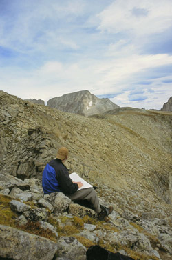 We discussed the Mummy Range but ruled that out as a winter only destination. And anyway, neither of us could really face that 6 to 7 mile approach. We discussed Pagoda but then decided that we would reserve that for a winter climb from the Glacier Gorge side. What about McHenry? Well, the road up to Bear Lake was still under construction and we would not be able to get an early morning start. . . no go for that one. We finished dinner without a decision but later that evening we decided on a shorter trip to Pilot Peak, a subsidiary highpoint down the ridge from Mount Alice. The peak was just a 12’er and that would spare us the altitude gain needed for a mid 13’er, like Mount Alice proper.
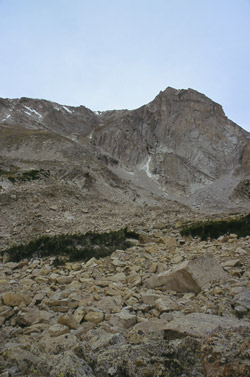 We set the alarm for 3 in the a.m. and got to the trailhead at 4. Our first two hours were more or less in the dark but we cruised up the highway of a trail toward Thunder Lake without any hitches. Then we took the spur trail to Lion Lake and met daybreak along the way. The trail remained strong enough for summer navigation but now we both started to take a good look at the route to facilitate a winter return. The trail climbed
 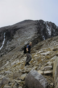 more strongly and after another hour or so we arrived at Lion Lake. The approach was now over so we took a break for some Cytomax and a bit of food. We could see “Pilot Peak” and decided to cut across the talus and boulder field to a slope that looked to be a good entry to a gully leading to the eastern flank of the peak. Enroute, we encountered one good sized weasel who took a few laps around us before moving onto other issues requiring his curious attention.
  The grassy flank proved to be a good approach and soon enough we were climbing up the couloir through a patch of snow here and there. The only problem was we were not seeing the one lake that the map said we should have in sight. No big thing, we came from Lion Lake and would return, it was just a case of figuring out how far we were going to be from Pilot Peak when we hit the ridgeline. Well, no big thing, we just climbed on to break the ridge . . . and figure out what mountain we were climbing.
 Once atop the ridge, we looked about and our lake was still missing in action. The altimeters were telling us that we had left our summit somewhere a few hundred feet below our position so it was time for us to figure out just where on the Front Range we had arrived. We contoured west a bit and looked into the North Inlet drainage and on to the southern flank of McHenrys Peak. Still not sure which way it was to Pilot Peak, we figured we’d hike to the nearby highpoint and see what the register said. No surprise . . . Mount Alice. Pilot Peak turned out to be a nearby minor player, easily missed in favor of the inviting couloir as compared to the sloping ledge route we should have taken.
  inviting couloir and then a less inviting eastern cliff face. Once on the saddle, we turned east and walked the gently falling ridge back to Lion Lake. We had left the water pump near the lake on the trip in and stopped to pick it up and pump some water for the hike out. The trip back to the trailhead would be a long one but it’s a highway of a trail and we made good enough time to even make a side trip to Ouzel Falls and get afternoon burgers in Estes Park before heading home.