Mount Lindsey
September, 2005 - Northwest Ridge
 I originally climbed Mt. Lindsey in June of 2000 via the standard northeast couloir route, a class 3 path to the summit. In the fall of 2005, Ed wanted to score Lindsey and I agreed to go along as I knew the route, the road, the trail cutoff, but most importantly because I wanted to get out. Ed and I took off on Friday afternoon and has a traffic jam free passage through Denver and Castle Rock before falling prey to the predictable jam in Colorado Springs, due to eternal construction on I-25. For those of you familiar with Denver's "TRex" highway improvement project, you know that it eventually became extinct, i.e. they finished. We the 'Springs must have chosen a non dinosaur, perhaps a crocodile as their project will seemingly outlast the age of the mammals. I originally climbed Mt. Lindsey in June of 2000 via the standard northeast couloir route, a class 3 path to the summit. In the fall of 2005, Ed wanted to score Lindsey and I agreed to go along as I knew the route, the road, the trail cutoff, but most importantly because I wanted to get out. Ed and I took off on Friday afternoon and has a traffic jam free passage through Denver and Castle Rock before falling prey to the predictable jam in Colorado Springs, due to eternal construction on I-25. For those of you familiar with Denver's "TRex" highway improvement project, you know that it eventually became extinct, i.e. they finished. We the 'Springs must have chosen a non dinosaur, perhaps a crocodile as their project will seemingly outlast the age of the mammals.
 We got off the highway at Walsenburg and cut back up on the back roads to eventually reach the approach to Lindsey via the Singing Creek Ranch. The approach can be confusing but I'd been down the path before and after a missed turn at one point, we were on track for the trail head. We made our way down the last 7 miles of one lane dirt, passing a few 2wd campers and made our way to the trail head. I had hoped to camp at or near the end of the road but there were a half dozen camps, so I backtracked for a half mile or so and found a pull off without neighbors. We set up camp and settled in for a short night. We got off the highway at Walsenburg and cut back up on the back roads to eventually reach the approach to Lindsey via the Singing Creek Ranch. The approach can be confusing but I'd been down the path before and after a missed turn at one point, we were on track for the trail head. We made our way down the last 7 miles of one lane dirt, passing a few 2wd campers and made our way to the trail head. I had hoped to camp at or near the end of the road but there were a half dozen camps, so I backtracked for a half mile or so and found a pull off without neighbors. We set up camp and settled in for a short night.
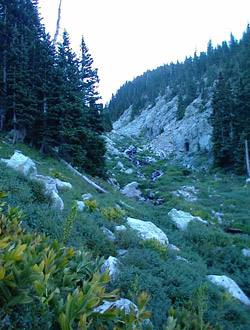
 We wanted to get an early start, no too early, but early enough to beat any afternoon thunderstorms and facilitate an off the summit hour no later than noon. I knew the trail and after we shuttled back to the trail head in the truck, we were off. The first part of the climb is along Huerfano Creek and I found the trail to much more defined than it was five years earlier. Before, I remembered it to be more braided but this time there was no doubt as to the main traffic course. We meandered back and forth across the creek and then cut up the left bank as the trail transitioned into the slope. I knew were were close to the drainage where we would cut up along the flank of Iron Nipple and climb into the upper valley that lies below the climb of Lindsey proper. We wanted to get an early start, no too early, but early enough to beat any afternoon thunderstorms and facilitate an off the summit hour no later than noon. I knew the trail and after we shuttled back to the trail head in the truck, we were off. The first part of the climb is along Huerfano Creek and I found the trail to much more defined than it was five years earlier. Before, I remembered it to be more braided but this time there was no doubt as to the main traffic course. We meandered back and forth across the creek and then cut up the left bank as the trail transitioned into the slope. I knew were were close to the drainage where we would cut up along the flank of Iron Nipple and climb into the upper valley that lies below the climb of Lindsey proper.
 The cut-off was obvious and as I promised Ed, the slog up the drainage was a ball buster. it is steep but there is a good trail and, honestly, about 20 minutes of work will yield the more mellow slopes of the upper valley. We crossed the tributary creek, stopping to pump some water, and then moved on into the flats above before we climbed to the saddle separating Lindsey from the lowermost reaches of the ridge leading off to Gash Ridge on Blanca peak. I think this flat meadow area is one of the prettier places I've come across in climbing 14'ers. The trail is marked cairn to cairn and at the far end, we climbed a bit of a braided path to the saddle proper. The next hurdle was to climb up to the saddle that divided Iron Nipple from Lindsey, a talus hopping adventure along a well marked path through the rocks. The trail trends south and it really is not much of a climb to the saddle. The cut-off was obvious and as I promised Ed, the slog up the drainage was a ball buster. it is steep but there is a good trail and, honestly, about 20 minutes of work will yield the more mellow slopes of the upper valley. We crossed the tributary creek, stopping to pump some water, and then moved on into the flats above before we climbed to the saddle separating Lindsey from the lowermost reaches of the ridge leading off to Gash Ridge on Blanca peak. I think this flat meadow area is one of the prettier places I've come across in climbing 14'ers. The trail is marked cairn to cairn and at the far end, we climbed a bit of a braided path to the saddle proper. The next hurdle was to climb up to the saddle that divided Iron Nipple from Lindsey, a talus hopping adventure along a well marked path through the rocks. The trail trends south and it really is not much of a climb to the saddle.
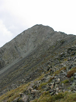
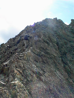
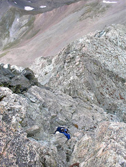
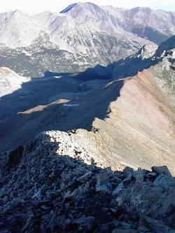 From the saddle, the trail to the north face couloirs takes off on a somewhat horizontal traverse before climbing through the couloir toward the summit. That was not our route, as i told Ed that if I was going back to Lindsey, we were going to climb the class 4 northwest ridge route. We were at the start point for that venture and up we went. The route started off on the mellow side and not until one reaches a juncture with a perpendicular couloir does the climb head into the class 4 realm. But, once past that juncture, the route is solid class 4 and there is enough exposure to keep one's thoughts focused on hand and foot holds. We had no problem picking the route and I think a qualified leader might be able to grade the route down to the high end of class 3 with a few judicious decisions, or alternatively, a Scoutmaster can grade it up into the low class 5 range if no effort at all. I took the lead and held us in the upper range of class 4 climbing as we did not have a rope or any protection along for the climb. i.e. a fun route with a clear means to reverse onto more mellow ground. There are a number of good friction moves and opportunities to take a digger if one fails to pay attention to the terrain. Ed and I have climbed together on similar ground in Canada and have established a comfort range that this route fit into without protection. I would not however, suggest that one skip the rope for the crux moves on this ridge if there is any doubt in one's mind. From the saddle, the trail to the north face couloirs takes off on a somewhat horizontal traverse before climbing through the couloir toward the summit. That was not our route, as i told Ed that if I was going back to Lindsey, we were going to climb the class 4 northwest ridge route. We were at the start point for that venture and up we went. The route started off on the mellow side and not until one reaches a juncture with a perpendicular couloir does the climb head into the class 4 realm. But, once past that juncture, the route is solid class 4 and there is enough exposure to keep one's thoughts focused on hand and foot holds. We had no problem picking the route and I think a qualified leader might be able to grade the route down to the high end of class 3 with a few judicious decisions, or alternatively, a Scoutmaster can grade it up into the low class 5 range if no effort at all. I took the lead and held us in the upper range of class 4 climbing as we did not have a rope or any protection along for the climb. i.e. a fun route with a clear means to reverse onto more mellow ground. There are a number of good friction moves and opportunities to take a digger if one fails to pay attention to the terrain. Ed and I have climbed together on similar ground in Canada and have established a comfort range that this route fit into without protection. I would not however, suggest that one skip the rope for the crux moves on this ridge if there is any doubt in one's mind.
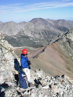 The grade of the climbing mellows to class 2 above the obvious steep pitch and then it is just an up and down talus strewn walk to the summit. We were perhaps 100 yards from the summit when I handed a water bottle to Ed and got a static electric shock. At about the same time, our hiking poles took to buzzing and the hair on our arms stood on end. This is what I call an indicator of a concluded climb . . . even though we we had the summit in sight. We were also just yards from the juncture with the couloir route and I will say from that climb that one can run down class 3 ground with the proper motivation. It was an easy call, turn right and live, or bag the summit and perhaps get fried. The grade of the climbing mellows to class 2 above the obvious steep pitch and then it is just an up and down talus strewn walk to the summit. We were perhaps 100 yards from the summit when I handed a water bottle to Ed and got a static electric shock. At about the same time, our hiking poles took to buzzing and the hair on our arms stood on end. This is what I call an indicator of a concluded climb . . . even though we we had the summit in sight. We were also just yards from the juncture with the couloir route and I will say from that climb that one can run down class 3 ground with the proper motivation. It was an easy call, turn right and live, or bag the summit and perhaps get fried.
Other climbers were coming up and we expressed our thoughts as to the prudence of continuing but there was but one small cloud in the sky (over the top of Lindsey) and not a sign of lightning or thunder. The majority of them held for a bit and then climbed (not having the advantage of our electromagnetic experience), we retreated, having missed the summit by a mere 300 feet or so.
The rest of the story . . .
We went on back to camp and enjoyed a great camp dinner and a brief discussion of what we were going to do on Sunday. We had talked of climbing Ellingwood Point from this drainage but there was Lindsey, so close and yet so far (7 miles) away. We knew where we were going the next day and yes, we scored the summit the next morning, via the north ridge . . . again .
|
