Casco Peak
October 24, 2009 - Winter - Northeast Slopes
The Independence Pass "Snotel" site noted that there was very little snow at Independence Pass and our climb of Mount Buckskin, the prior Saturday, led us to think that we might have one last chance to climb a few more high 13'ers before winter proper arrived. We decided to make a weekend of the task and set our sights on a Saturday climb of Casco Peak, Frasco Benchmark and French Mountain, followed by a short climb the next day of Lackawanna Peak. We found the snotel site data to be about as representative of snow levels in the northern Sawatch as a fart is trustworthy. Our first sight of the valley from which we planned to climb the three peaks told the true story . . . the valley was in the grip of old man winter.
 The trip started on Friday night with a leisurely drive to the Super 8 in Leadville. While we could have opted to camp, we did not expect to arrive until after 9 p.m. and neither of us really wanted to find and set up camp in the dark and snow, and then get up at zero dark 30 to start climbing. Instead we decided to rough it in Leadville proper and then hit the Halfmoon trail head the next morning at a reasonable hour. The alarm failed to go off but that was OK as we awoke at 6:00 a.m. and there was still no sign of any sunrise through the window. No problem . . . we had decided the night before to aim for a 7:00 a.m. departure from the trail head, figuring that the approach and retreat on an old mining road would negate any need to absolutely be back at the truck by dark. The trip started on Friday night with a leisurely drive to the Super 8 in Leadville. While we could have opted to camp, we did not expect to arrive until after 9 p.m. and neither of us really wanted to find and set up camp in the dark and snow, and then get up at zero dark 30 to start climbing. Instead we decided to rough it in Leadville proper and then hit the Halfmoon trail head the next morning at a reasonable hour. The alarm failed to go off but that was OK as we awoke at 6:00 a.m. and there was still no sign of any sunrise through the window. No problem . . . we had decided the night before to aim for a 7:00 a.m. departure from the trail head, figuring that the approach and retreat on an old mining road would negate any need to absolutely be back at the truck by dark.
 We got the climbing gear together, hefted the packs that were placed in order the night before, and went outside to find fresh snow covering the ground that just ten hours before was bare . . . not a lot of snow but it was still coming down. The National Weather Service zone forecast had prepared us for morning snow showers and we knew that the showers were predicted to peter out by mid morning, leading to a mostly sunny day with a high temperature in the low 40's. We drove over to the Halfmoon trail head and found little more than an inch of snow on the road all the way in from town. The clock read 7:30 when we left the truck and as we figured we had good weather in store, we expected to be out about 8 hours. We got the climbing gear together, hefted the packs that were placed in order the night before, and went outside to find fresh snow covering the ground that just ten hours before was bare . . . not a lot of snow but it was still coming down. The National Weather Service zone forecast had prepared us for morning snow showers and we knew that the showers were predicted to peter out by mid morning, leading to a mostly sunny day with a high temperature in the low 40's. We drove over to the Halfmoon trail head and found little more than an inch of snow on the road all the way in from town. The clock read 7:30 when we left the truck and as we figured we had good weather in store, we expected to be out about 8 hours.
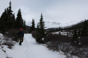
 The trail up the South Halfmoon Creek valley is an old mining road that starts out with a steep climb up and around a hairpin turn before climbing steadily to cross South Halfmoon Creek at about the 1 mile mark. We opted to avoid the log crossing as it was covered in snow and instead, due to low water, just rock hopped with dry feet to the other side of the creek. The road to this point had between one and two inches of snow on it from the night before but once we crossed the creek, the snow started getting a bit deeper, adding an inch or two with every half mile of travel further up the valley. By the time we first came along side the terminus of the east ridge of French Mountain (next to the rock slides that cut the trail), we were walking through 4 inches of snow and by the time we cut a more northerly track through the last half mile of trees, we were up to about a foot of snow. The trail up the South Halfmoon Creek valley is an old mining road that starts out with a steep climb up and around a hairpin turn before climbing steadily to cross South Halfmoon Creek at about the 1 mile mark. We opted to avoid the log crossing as it was covered in snow and instead, due to low water, just rock hopped with dry feet to the other side of the creek. The road to this point had between one and two inches of snow on it from the night before but once we crossed the creek, the snow started getting a bit deeper, adding an inch or two with every half mile of travel further up the valley. By the time we first came along side the terminus of the east ridge of French Mountain (next to the rock slides that cut the trail), we were walking through 4 inches of snow and by the time we cut a more northerly track through the last half mile of trees, we were up to about a foot of snow.
To our pleasure, someone had come this far on a 4 wheeler and left two ruts in the snow that, aside from being too narrow for my skewed footsteps, served to lessen some of the effort needed to walk the road. However, the intrepid 4 wheeler did not get beyond the last small creek crossing before the last 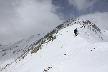 copse of trees . . . and from there on we cut trail through 12 to 16 inches of powder. Neither of us brought snow shoes but given the powdery nature of the snow, I doubt we would have gained enough flotation to make the extra weight of the snowshoes a justifiable addition to our winter load. After the last of the trees, we looked at the various routes to gain the ridge that runs from southeast of Casco Peak around to southwest of French Mountain. Though we had both been up this valley before, and G had climbed Casco 15 years before, we engaged in a lively discussion as to which peaks were which, putting aside the obvious advantage to be had by simply referring to either of the two maps in the truck. copse of trees . . . and from there on we cut trail through 12 to 16 inches of powder. Neither of us brought snow shoes but given the powdery nature of the snow, I doubt we would have gained enough flotation to make the extra weight of the snowshoes a justifiable addition to our winter load. After the last of the trees, we looked at the various routes to gain the ridge that runs from southeast of Casco Peak around to southwest of French Mountain. Though we had both been up this valley before, and G had climbed Casco 15 years before, we engaged in a lively discussion as to which peaks were which, putting aside the obvious advantage to be had by simply referring to either of the two maps in the truck.
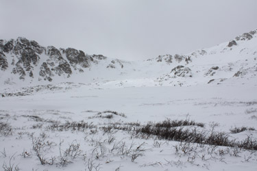
 Given the amount of snow in the valley, the need to give consideration to avalanche terrain and slide potential was clearly a necessity. The route from the point where the road turns hard toward French to the col separating Casco from the two low 13'er humps along the ridge stretching to the southeast seemed to offer the best connect the dot non-avalanche terrain based route. The basin below the col between Frasco and French was quite deep with Given the amount of snow in the valley, the need to give consideration to avalanche terrain and slide potential was clearly a necessity. The route from the point where the road turns hard toward French to the col separating Casco from the two low 13'er humps along the ridge stretching to the southeast seemed to offer the best connect the dot non-avalanche terrain based route. The basin below the col between Frasco and French was quite deep with 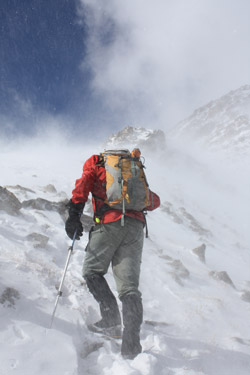 snow (2 feet) and seemed to offer more potential for slide trouble not to mention the trudge that it would take to cross to the base of the alternate col. We chose to head for Casco via the tamer route, followed by a descent over French if we chose to go beyond the summit of Casco. The route we chose to gain the base of the col skirted a rocky lateral rise and then gave us access to the lowest angle course to the base of the climb up to the saddle. From the base of the saddle, we connected shallower flats to avoid convex starting zones and run outs to gain the ridge. snow (2 feet) and seemed to offer more potential for slide trouble not to mention the trudge that it would take to cross to the base of the alternate col. We chose to head for Casco via the tamer route, followed by a descent over French if we chose to go beyond the summit of Casco. The route we chose to gain the base of the col skirted a rocky lateral rise and then gave us access to the lowest angle course to the base of the climb up to the saddle. From the base of the saddle, we connected shallower flats to avoid convex starting zones and run outs to gain the ridge.
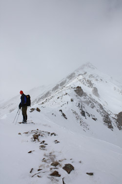
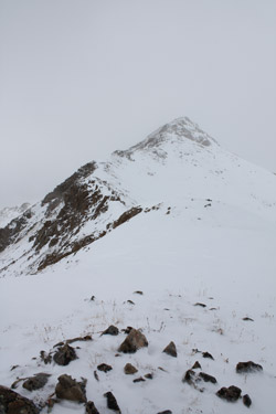
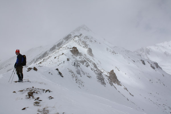
Working through avi terrain is always a matter of experience and personal risk tolerance but at no time did either of us feel uncomfortable with this portion of the climb. However, given the wind that was moving snow about the valley, I'd venture to say that my willingness to cross the same ground after another loading of snow would be substantially lessened. Regardless, we soon gained the col and after a short detour to the southeast (read as "some doofus had it fixed in his mind that Casco was actually Frasco") we started up the ridge toward the summit of Casco. The correct ridge line runs from 13,300 to the 13,908 summit of Casco via a 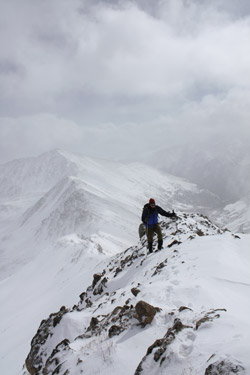 couple of humps and makes for a straight forward class 2 ridge climb all the way. However, the winds that had been relatively tame in the valley during the course of our approach, were now whipping across the ridge, not constantly but in 40 mph bursts loaded with ice pellets and snow from the day long series of squalls blowing in from the west. The ridge did however provide us with a steady elevation gain, alternating between skirting the edge and climbing the ridge proper, all depending upon the presence and depth of the cornice that was starting to take hold. couple of humps and makes for a straight forward class 2 ridge climb all the way. However, the winds that had been relatively tame in the valley during the course of our approach, were now whipping across the ridge, not constantly but in 40 mph bursts loaded with ice pellets and snow from the day long series of squalls blowing in from the west. The ridge did however provide us with a steady elevation gain, alternating between skirting the edge and climbing the ridge proper, all depending upon the presence and depth of the cornice that was starting to take hold.
The snow of the uppermost part of the ridge finally slowed our pace as it was two or more feet in depth, forcing us to wallow through as we connected rock steps and large talus and boulders to maintain our upward progress with the least amount of effort. We would cut left to an outcrop, then do the same to the right and then just plow through straight ahead . . . whichever course looked to present the least resistance. We finally summitted, having taken a full hour to push from 13,000 to the summit just over 600 feet higher. The summit of Casco is a jumble of boulders that presented no real shelter but given the temperature and the wind, we opted to spend little more than a few minutes on the 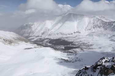 summit. We did take time to look at the route onward to Frasco and French and decided that, given the time, the most prudent move would be a retreat back down our ascent route, through familiar terrain that presented neither route finding issues or an unknown future degree of avalanche danger. summit. We did take time to look at the route onward to Frasco and French and decided that, given the time, the most prudent move would be a retreat back down our ascent route, through familiar terrain that presented neither route finding issues or an unknown future degree of avalanche danger.
We retreated back down the ridge, needing much less time and effort to regain the 13,300 foot saddle that we would drop down from to the ruins of a mine below. The wind abated as soon as we dropped below the crest of the cornice forming at the edge of the col and we post holed our way through the powder to the base of the col, more or less along our ascent route, to intercept the old mining road about one quarter mile above tree line. Once we hit 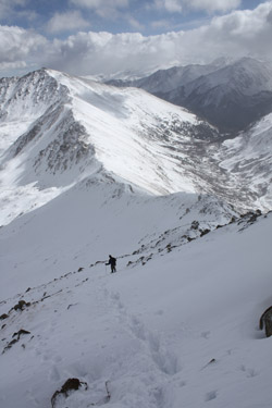 the road, we shifted the legs into descent mode and walked our track on back down to the trees and then along course of the road for about 4 miles to the truck parked at the trail head too far below. We arrived at the truck at 4:30, having taken a full 9 hours to cover about 11 miles and score one summit in lieu of the planned three. However, after many years of winter climbing, I've long come to know and understand that one summit per three or four attempts is a track record that I can be proud of. the road, we shifted the legs into descent mode and walked our track on back down to the trees and then along course of the road for about 4 miles to the truck parked at the trail head too far below. We arrived at the truck at 4:30, having taken a full 9 hours to cover about 11 miles and score one summit in lieu of the planned three. However, after many years of winter climbing, I've long come to know and understand that one summit per three or four attempts is a track record that I can be proud of.
We drove on back to Leadville and took advantage of the unlimited hot water at the Super 8 before heading for Quincy's to fortify the body for the next day's attempt of Lackawanna. Post dinner, we took in the weather report and the prediction of afternoon snow along the I-25 corridor in addition to another 6 or 9 overnight inches in the northern Sawatch Range. Given that we had to drive to Cheyenne and not just make it to Denver, we opted to pull out the next morning and leave Lackawanna for another day.
|
