North Carbonate a.k.a. Cronin Peak
June 14, 2009 - East Ridge Variation
 The first time I ascended the Baldwin Creek jeep road, it was on foot, all the way from the hard road to the summit of Mount Antero. That was in October of 1983 and, at the time, my ultimate goal in life was to graduate from the School of Mines and get a job in a bust economy that that would allow me to purchase a 4WD Toyota pick-up. That would be the life, no more dirt road hikes because either my VW Thing or my friend's purple 1986 AMC Pacer could not get us beyond the two wheel drive trail head. Well, life has a way of coming around full circle and after 26 years and 450,000 miles behind the wheel of two Toyota pick-ups, 4WD of course, I found myself at the start of the Baldwin Creek jeep road. I was not going to walk this time. I put the truck in 4WD and three miles later I had stepped back 26 years to once again stand on the trail up Mount Antero. The first time I ascended the Baldwin Creek jeep road, it was on foot, all the way from the hard road to the summit of Mount Antero. That was in October of 1983 and, at the time, my ultimate goal in life was to graduate from the School of Mines and get a job in a bust economy that that would allow me to purchase a 4WD Toyota pick-up. That would be the life, no more dirt road hikes because either my VW Thing or my friend's purple 1986 AMC Pacer could not get us beyond the two wheel drive trail head. Well, life has a way of coming around full circle and after 26 years and 450,000 miles behind the wheel of two Toyota pick-ups, 4WD of course, I found myself at the start of the Baldwin Creek jeep road. I was not going to walk this time. I put the truck in 4WD and three miles later I had stepped back 26 years to once again stand on the trail up Mount Antero.
 The previous day I'd climbed Crystal Peak at the far north end of the 10 Mile Range and I'd had a post holin' good time of it. I figured if I played my cards right, one weekend could give me both a summer climb and a spring snow climb. Hence I started outside of Leadville where spring was still hanging on, at least before the sun came up, and then on the second day, I drove just 35 mile south to the "banana belt" of the Sawatch Range for a summer day hike. I labored under the false impression that I could find a camp site on the road leading to St. Elmo, as I had done so many years before . . . but that was "back in the day", before you made reservations on line to snag a spot in a campground overseen by the campground host with the $250k RV with the slide out sides, the dish network dish on the tripod next to the spinning yard ornaments and paste patio light delineating the edges of the green indoor/outdoor carpet. That is what camping in 2009 is all about right? The previous day I'd climbed Crystal Peak at the far north end of the 10 Mile Range and I'd had a post holin' good time of it. I figured if I played my cards right, one weekend could give me both a summer climb and a spring snow climb. Hence I started outside of Leadville where spring was still hanging on, at least before the sun came up, and then on the second day, I drove just 35 mile south to the "banana belt" of the Sawatch Range for a summer day hike. I labored under the false impression that I could find a camp site on the road leading to St. Elmo, as I had done so many years before . . . but that was "back in the day", before you made reservations on line to snag a spot in a campground overseen by the campground host with the $250k RV with the slide out sides, the dish network dish on the tripod next to the spinning yard ornaments and paste patio light delineating the edges of the green indoor/outdoor carpet. That is what camping in 2009 is all about right?
 Well, the campground hosts, the internet and the reservations had done a job on this solo climber coming down from Wyoming to snag a tent spot for the night . . . just wasn't going to happen in the summer season outside of Buena Vista. So I wasted an hour in the hunt before heading back to Buena Vista, having a mediocre meal at a restaurant staffed by wannabe raft guides who would have sunk like rocks due to the amount of extraneous metal piercing their heads in places where the original design for the human head did not call for extra holes. Dinner complete, I went north toward Leadville about 14 miles and cut off on the road toward Vicksburg and pitched camp at the Colorado DNR camp site at the head of the lake. Nothing fancy, really nothing more than an open field but would you believe it was only half full, it was dead quiet and it turned out to offer a great night's sleep for the right price. Well, the campground hosts, the internet and the reservations had done a job on this solo climber coming down from Wyoming to snag a tent spot for the night . . . just wasn't going to happen in the summer season outside of Buena Vista. So I wasted an hour in the hunt before heading back to Buena Vista, having a mediocre meal at a restaurant staffed by wannabe raft guides who would have sunk like rocks due to the amount of extraneous metal piercing their heads in places where the original design for the human head did not call for extra holes. Dinner complete, I went north toward Leadville about 14 miles and cut off on the road toward Vicksburg and pitched camp at the Colorado DNR camp site at the head of the lake. Nothing fancy, really nothing more than an open field but would you believe it was only half full, it was dead quiet and it turned out to offer a great night's sleep for the right price.
 I'd set the alarm for 4 a.m. but when it went off, I just did not connect the sound with the need to get up. I chose 4 a.m. because I was a solid 28 miles from the start of the Baldwin Creek Road and I wanted to get up the road not quite at the alpine start hour but in time for a reasonably early summit and return to the truck. By 4:20, the approach of dawn told me it was indeed time to get up and within a half hour, the tent was down, the sleeping bag stuffed and the seriously frosted tent was jammed in its sack, leaving me the task of drying it out when I got home. I scraped the windshield and was Buena Vista bound and soon enough turning off the road at Nathrop to go the last twelve miles to the start of the Baldwin Creek track. I'd set the alarm for 4 a.m. but when it went off, I just did not connect the sound with the need to get up. I chose 4 a.m. because I was a solid 28 miles from the start of the Baldwin Creek Road and I wanted to get up the road not quite at the alpine start hour but in time for a reasonably early summit and return to the truck. By 4:20, the approach of dawn told me it was indeed time to get up and within a half hour, the tent was down, the sleeping bag stuffed and the seriously frosted tent was jammed in its sack, leaving me the task of drying it out when I got home. I scraped the windshield and was Buena Vista bound and soon enough turning off the road at Nathrop to go the last twelve miles to the start of the Baldwin Creek track.
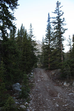
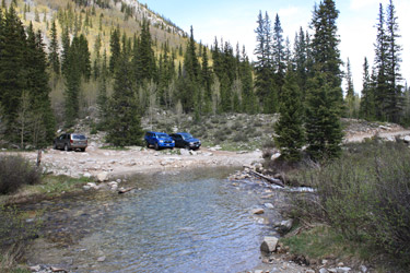
 The Baldwin Creek road was actually rougher than I recalled it, but after two and one half decades I had very little recall of the route itself. I did note that it was steep but that the Tacoma easily surmounted all obstacles, hummocks and swales. Bear in mind this is no Como Lake road but it does give one the opportunity to give some thought to course and clearance. I made the road junction on the bank of Baldwin Creek in good time and found one other group already parked and making final preparations for a day's climb. The had axes, decent gear and obviously enough wherewithall to get an earlier start than I managed to pull together. They were soon off across the stream, leaving me to get my climbing gear together and be off from the car just a few minutes before 6:30. The Baldwin Creek road was actually rougher than I recalled it, but after two and one half decades I had very little recall of the route itself. I did note that it was steep but that the Tacoma easily surmounted all obstacles, hummocks and swales. Bear in mind this is no Como Lake road but it does give one the opportunity to give some thought to course and clearance. I made the road junction on the bank of Baldwin Creek in good time and found one other group already parked and making final preparations for a day's climb. The had axes, decent gear and obviously enough wherewithall to get an earlier start than I managed to pull together. They were soon off across the stream, leaving me to get my climbing gear together and be off from the car just a few minutes before 6:30.
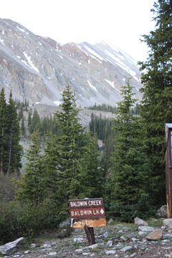
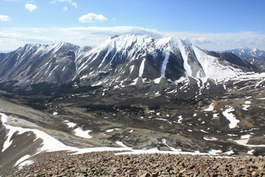
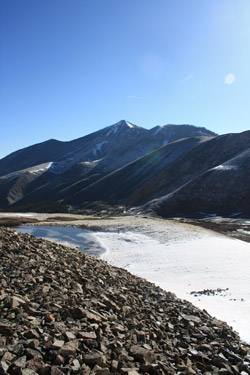 I managed to get across the stream with dry feet, thanks to a few well placed cobbles and the judicious use of hiking poles. The road from there leads virtually to the summit of Antero, well, not quite if I remember, but surely to a shoulder from which the final push to the summit starts. I was not going that far as my goal was to summit North Carbonate or Cronin Peak as it is now called. North Carbonate is #75 on the Centennial peak list and Jerry Roach offers two routes to its high point. One is at the Easr Ridge route, accessed from the Antero Road as it attains a point that allows one to drop down a connecting ridge to traverse over to the summit of Cronin. The other requires a cross country track from the first juncture of the Antero road with the tree line, after which one gains the North Ridge and then the summit. I managed to get across the stream with dry feet, thanks to a few well placed cobbles and the judicious use of hiking poles. The road from there leads virtually to the summit of Antero, well, not quite if I remember, but surely to a shoulder from which the final push to the summit starts. I was not going that far as my goal was to summit North Carbonate or Cronin Peak as it is now called. North Carbonate is #75 on the Centennial peak list and Jerry Roach offers two routes to its high point. One is at the Easr Ridge route, accessed from the Antero Road as it attains a point that allows one to drop down a connecting ridge to traverse over to the summit of Cronin. The other requires a cross country track from the first juncture of the Antero road with the tree line, after which one gains the North Ridge and then the summit.
I was opting for the East Ridge as I wanted to take some photos of Antero to update an my web page associated with my very long ago climb of that peak. I made good time up the road, crossing the stream and eventually cutting tree line. I 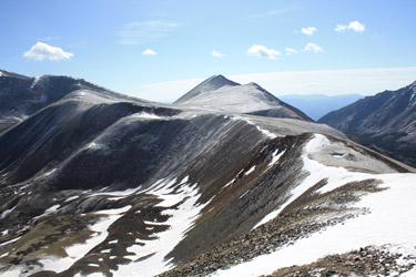 looked up at the Antero road as it switched back and forth to gain the ridge and I just could not see the trudge up that course enhancing my enjoyment of this beautiful blue sky morning. No, that route was not going to do it for me, not today. Well, I'd already passed the cut off for the other route so there was only one choice, make my way across the upper crescent of the valley, connecting a series of morrainal hummocks to gain altitude at a reasonable pace without suffering too many descents along the way. looked up at the Antero road as it switched back and forth to gain the ridge and I just could not see the trudge up that course enhancing my enjoyment of this beautiful blue sky morning. No, that route was not going to do it for me, not today. Well, I'd already passed the cut off for the other route so there was only one choice, make my way across the upper crescent of the valley, connecting a series of morrainal hummocks to gain altitude at a reasonable pace without suffering too many descents along the way.
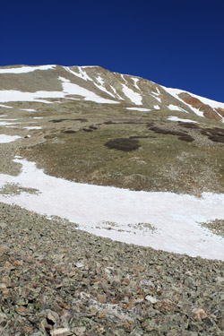
 As I stood on the edge of the road, I noticed that the heavy frost or light snow of the past evening had marked a trace clearly trod by the feet of hikers and climbers before me. This seemed like an invitation so I accepted and began my slowly ascending traverse around the head of the valley, intending to connect with a snowfield that appeared to offer relief from the likely scree ascent otherwise required to eventually gain the East Ridge. I gave some thought to whether the snow would be hard enough to travel across but really figured that it had been pretty well burned and would offer an icy layer of summer snow suitable for crampons and ice axe. The course offered easy travel, first along disjointed trail segments, then across scree and small talus fields. As I stood on the edge of the road, I noticed that the heavy frost or light snow of the past evening had marked a trace clearly trod by the feet of hikers and climbers before me. This seemed like an invitation so I accepted and began my slowly ascending traverse around the head of the valley, intending to connect with a snowfield that appeared to offer relief from the likely scree ascent otherwise required to eventually gain the East Ridge. I gave some thought to whether the snow would be hard enough to travel across but really figured that it had been pretty well burned and would offer an icy layer of summer snow suitable for crampons and ice axe. The course offered easy travel, first along disjointed trail segments, then across scree and small talus fields.
As I approached the snow, the scree ran out and the course offered me a traverse across perhaps 200 yards of large talus, the good loose stuff that you hop from point to point on and hope that the hiking poles will save your butt when a rock shifts. Now I'm going to admit that I'm climbing solo on a high 13'er, off the guidebook trail, and not figuring to link up with anyone else for the climb. So I'll also note that I've got a 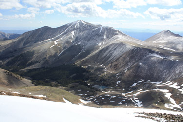 down jacket, bivy sack, extra quart of water, and PLB in my pack. I've kind of taken a liking to having the PLB along for the ride on solo trips along with the gear for an overnight. You never know when you might twist or break something and I ahve no need to spend more time out than necessary. Add to that a very clear instruction to the wife as to which peak I'm on and a set call in time . . . I was comfortable with the route. down jacket, bivy sack, extra quart of water, and PLB in my pack. I've kind of taken a liking to having the PLB along for the ride on solo trips along with the gear for an overnight. You never know when you might twist or break something and I ahve no need to spend more time out than necessary. Add to that a very clear instruction to the wife as to which peak I'm on and a set call in time . . . I was comfortable with the route.
I put the talus field behind me and hopped onto the snow hoping not to posthole up to my knee or behind. Not the case as the snow was just as I'd expected, a summer burn and freeze job with some soft grip on top, enough to give a good side step and allow travel with an axe in one hand and a non lopped hiking pole in the other. left, right. left, I comfortably traversed my way up the snowfield aiming first for the highest extension to the ridge and then opting instead to gain about 3/4 of the available elevation before cutting left to minimize the amount of scree to be crossed down to about 50 yards. I got to the rock and there lay a climber's trail leading right to the ridge where I'd aimed for an hour before from the other side of the valley.
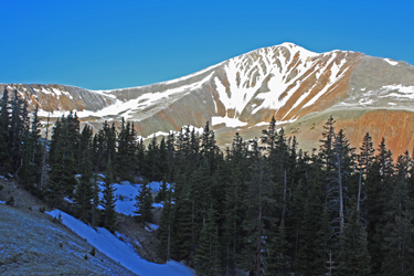
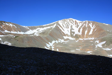
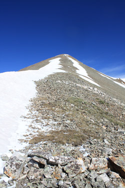
 Once on the ridge, it was as time to take breather, the first since leaving the Antero road and assess how much ridge lay between me and the summit. Not much really, likely about 400 feet of vertical with a line of snow leading the way and a small cornice remnant guarding the summit flat. For 400 hundred feet, I sure seemed to pay the price. I think I stopped 4 times along the way to take in the view but more honestly to rest a bit. Usually, I have a second wind for the final 500 feet of a climb but such was not the case today. I gave the snow a shot but it was shallow and rotten so it was over to the rock where I connected links of the summer trail to arrive at the final patch of snow before the summit. I traversed first to the right and then once back left before kicking five or six good steps up a short steep section to land me on the summit proper. Once on the ridge, it was as time to take breather, the first since leaving the Antero road and assess how much ridge lay between me and the summit. Not much really, likely about 400 feet of vertical with a line of snow leading the way and a small cornice remnant guarding the summit flat. For 400 hundred feet, I sure seemed to pay the price. I think I stopped 4 times along the way to take in the view but more honestly to rest a bit. Usually, I have a second wind for the final 500 feet of a climb but such was not the case today. I gave the snow a shot but it was shallow and rotten so it was over to the rock where I connected links of the summer trail to arrive at the final patch of snow before the summit. I traversed first to the right and then once back left before kicking five or six good steps up a short steep section to land me on the summit proper.
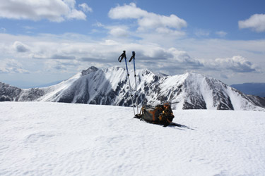 North Carbonate's summit is the juncture of three gentle Sawatch ridge lines and as such is a flattish hump suitable for standing about, more properly, wandering about here and there to take photos and find a spot to sit for a bit. I dropped the pack and stabbed the poles to do just that but within 5 or 6 minutes, I'd taken my photos and was ready to mount up and head on back down. I considered which route to take down, planning at first to come down the East Ridge but then my frugal side told me to re-trace my ascent in the hope that the glove that had fallen from my pocket might be found between the ridge and the top of the snow field. I heeled my way down the cornice remnant, and stepped lively down the rounder ridge crest to the drop off point where I snagged a summer tail segment. About half way to the snow field, there it was my glove, no need to spend $30 for a new pair now . . . North Carbonate's summit is the juncture of three gentle Sawatch ridge lines and as such is a flattish hump suitable for standing about, more properly, wandering about here and there to take photos and find a spot to sit for a bit. I dropped the pack and stabbed the poles to do just that but within 5 or 6 minutes, I'd taken my photos and was ready to mount up and head on back down. I considered which route to take down, planning at first to come down the East Ridge but then my frugal side told me to re-trace my ascent in the hope that the glove that had fallen from my pocket might be found between the ridge and the top of the snow field. I heeled my way down the cornice remnant, and stepped lively down the rounder ridge crest to the drop off point where I snagged a summer tail segment. About half way to the snow field, there it was my glove, no need to spend $30 for a new pair now . . .
 I broke out the axe, stashed the poles on my pack and again heel stepped my down the snow and soon enough landed at the top of the talus traverse. Back I crossed, negotiating the wobbly rocks here and there, soon making it to the small stuff and sufficient trail segments to make the return to the Antero road a matter of just walking the hummocky course back to my road interception point. From there, and after a goo and sip, it was a mile or so on back down the road to the Baldwin Creek crossing and that Toyota truck, parked on the other side, waiting to take me back down the last three miles of road, unlike my first and only prior trip to this trail head. I broke out the axe, stashed the poles on my pack and again heel stepped my down the snow and soon enough landed at the top of the talus traverse. Back I crossed, negotiating the wobbly rocks here and there, soon making it to the small stuff and sufficient trail segments to make the return to the Antero road a matter of just walking the hummocky course back to my road interception point. From there, and after a goo and sip, it was a mile or so on back down the road to the Baldwin Creek crossing and that Toyota truck, parked on the other side, waiting to take me back down the last three miles of road, unlike my first and only prior trip to this trail head.
The climb took five hours start to finish and as I got to the end, the blue sky had just about completed the conversion from morning bluebird to afternoon clouds and pending thunderstorms. I'd left the summit just a few minutes after 9:30 so even though I'd gotten a late start, I'd played the weather card right and scored a new summit on an almost wind free day.
|
