Fairchild Mountain
August 24, 2008 - Lawn Lake Approach
 With three winter attempts to climb Fairchild Mountain, it was surely time to just get the task over with during the summer and move on to a less vexing mountain. I talked Bob into taking a shot at Fairchild and we left Cheyenne at the relatively late hour of 3 a.m. I knew we had a two hour run to the Lawn Lake trail head and then a very long walk after we got there. Bob indicated that his longest hike to date had been about 14 miles . . . I planned to take care of that number before the day was out. With three winter attempts to climb Fairchild Mountain, it was surely time to just get the task over with during the summer and move on to a less vexing mountain. I talked Bob into taking a shot at Fairchild and we left Cheyenne at the relatively late hour of 3 a.m. I knew we had a two hour run to the Lawn Lake trail head and then a very long walk after we got there. Bob indicated that his longest hike to date had been about 14 miles . . . I planned to take care of that number before the day was out.
I've been up the trail to Lawn Lake in the winter on skis and on snow shoes but I had never walked the path, i.e. been able to see the ground. I knew we'd make better time than a winter snowshoe trip but regardless, the trip to the summit of Fairchild would be at least an 17 mile effort, if we pulled 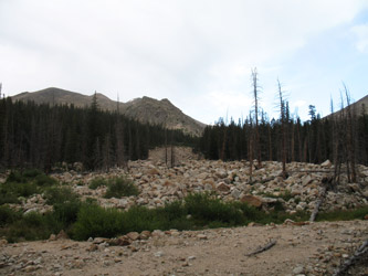 it off. The distance was not a factor in my mind but the late start did offer the potential for a cloud and thunderstorm buildup that could very well curtail our effort piteously close to the summit. it off. The distance was not a factor in my mind but the late start did offer the potential for a cloud and thunderstorm buildup that could very well curtail our effort piteously close to the summit.
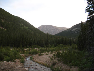
We left the trail head at 5:20 and set a brisk pace that put us up the switchbacks in no time and onto the relatively flat path that does gain a few thousand feet over 6+ miles but does so in a relatively kind and graceful way. We were astride the cut off for the three campsites located about 2 1/2 miles up the path at about the time the sun came up, seems like I always hit this particular point at sun-up. I pointed out our course up the side of the valley to Bob and that once we were astride the nearest portion of Mummy Mountain, we would have covered just a bit less than six miles. In other words, we would arrive at the point where, with the exception of our successful climb of Mummy Mountain, the blowing snows turned our past summit efforts into to failure, failure, and again failure.
 We arrived at the 5.7 mile mark/trail juncture at just a bit over the 2 1/2 hour mark and after a drink and shot of Goo, we were off to Lawn Lake proper. I pointed out our winter camp site to Bob, located just before we came into the open area below the failed dam, afterwhich we traversed along the lake to its far terminus. The trail climbs a bit at this point to get you over onto the right side of the valley where there is a trail juncture that allows one to continue more left (to a couple of alpine lakes) or straight to reach the "Saddle" The saddle is just that, the saddle that separates Fairchild from Hague's Peak. There is a clear trail all the way to the saddle with the exception of a segment or two over cobble covered melt water courses that even at this late date were still running quite well, i.e. no need to lug water to just below the saddle if weight economy had been the name of my game. We arrived at the 5.7 mile mark/trail juncture at just a bit over the 2 1/2 hour mark and after a drink and shot of Goo, we were off to Lawn Lake proper. I pointed out our winter camp site to Bob, located just before we came into the open area below the failed dam, afterwhich we traversed along the lake to its far terminus. The trail climbs a bit at this point to get you over onto the right side of the valley where there is a trail juncture that allows one to continue more left (to a couple of alpine lakes) or straight to reach the "Saddle" The saddle is just that, the saddle that separates Fairchild from Hague's Peak. There is a clear trail all the way to the saddle with the exception of a segment or two over cobble covered melt water courses that even at this late date were still running quite well, i.e. no need to lug water to just below the saddle if weight economy had been the name of my game.
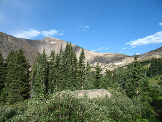
 My game was conditioning, so I splurged and lugged a full quart for the whole of the hike. The trail does steepen a bit before the saddle proper but except for one steep section, this is truly just a hike, albeit a rather long hike. We took a sip and Goo break at the saddle before deciding to first take on a climb of Fairchild. After the first summit, we would cross the saddle and take a shot at Hagues in the opposite direction. There is no real trail to the summit of Fairchild but there do appear to be some trail segments here and there. The first third of so is a tundra hike but after the first real topographic roll, the character of the ground changes from tundra to scree patches and mostly big rocks to hop. Not quite the rock hopping effort of an approach to K2 on Capitol but still the poles are very handy as your hop up toward the summit. My game was conditioning, so I splurged and lugged a full quart for the whole of the hike. The trail does steepen a bit before the saddle proper but except for one steep section, this is truly just a hike, albeit a rather long hike. We took a sip and Goo break at the saddle before deciding to first take on a climb of Fairchild. After the first summit, we would cross the saddle and take a shot at Hagues in the opposite direction. There is no real trail to the summit of Fairchild but there do appear to be some trail segments here and there. The first third of so is a tundra hike but after the first real topographic roll, the character of the ground changes from tundra to scree patches and mostly big rocks to hop. Not quite the rock hopping effort of an approach to K2 on Capitol but still the poles are very handy as your hop up toward the summit.
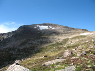 The climb is not steep but there are enough rolls that you never really know if the skyline is the summit or just a roll that will be followed by another gradual but boulder studded slope. Do that gig about 3 times and you will gain some flatter, but still boulder strewn ground, from which we spotted a particularly large rock with a wind wall built atop it. Yes, finally that was the summit, and we stopped there to cross hiking poles in triumph and get a bite to eat. I brought a Cottoneers' lunch, tortillas, Carl Buddig lunch meat and cheese sticks. not a modern alpinist's ideal menu but this was a summer hike and why not just pack picnic lunch? The climb is not steep but there are enough rolls that you never really know if the skyline is the summit or just a roll that will be followed by another gradual but boulder studded slope. Do that gig about 3 times and you will gain some flatter, but still boulder strewn ground, from which we spotted a particularly large rock with a wind wall built atop it. Yes, finally that was the summit, and we stopped there to cross hiking poles in triumph and get a bite to eat. I brought a Cottoneers' lunch, tortillas, Carl Buddig lunch meat and cheese sticks. not a modern alpinist's ideal menu but this was a summer hike and why not just pack picnic lunch?
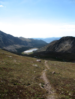
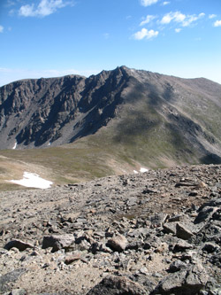 The trip down was a reverse of the hop to the top and quickly we regained the smoother rock studded tundra for the hike back to the saddle. I was keeping an eye out on a particular cloud that built up over the eastern flank of the peak and was growing dark on its underside and showing no sigh of moving on its way. I entertained the thought of climbing Hagues but as we descended the flank of Fairchild a major buildup was underway with a touch of thunder here and there. No obvious strikes but after doing this for two decades, I advised Bob that discretion was the better part of valor in this case and that we were going to hoof our way back to the car, about 7 miles distant. The trip down was a reverse of the hop to the top and quickly we regained the smoother rock studded tundra for the hike back to the saddle. I was keeping an eye out on a particular cloud that built up over the eastern flank of the peak and was growing dark on its underside and showing no sigh of moving on its way. I entertained the thought of climbing Hagues but as we descended the flank of Fairchild a major buildup was underway with a touch of thunder here and there. No obvious strikes but after doing this for two decades, I advised Bob that discretion was the better part of valor in this case and that we were going to hoof our way back to the car, about 7 miles distant.
We hoofed our way on back to the upper end of Lawn Lake passing an older gentleman who had every bit of 20 years on my 47 year old frame and who had walked in from the trail head that morning to the Saddle. We passed him and vice versa as we descended to the trail head and I can only hope to be in the shape he was when I am his age. I was impressed to say 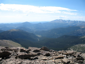 the least. We trooped back down to the lake, hugged the north shore on the strong trail and on back through the woods to the trail juncture at the 5.7 mile mark. I donned the Gore Tex top at this point in an effort to ward off the increasing number of rain drops that were coming from a strong bank of clouds atop Mummy Mountain and the valley we were to walk out. the least. We trooped back down to the lake, hugged the north shore on the strong trail and on back through the woods to the trail juncture at the 5.7 mile mark. I donned the Gore Tex top at this point in an effort to ward off the increasing number of rain drops that were coming from a strong bank of clouds atop Mummy Mountain and the valley we were to walk out.
We made good time going down the trail and passed a number of bozos coming up the trial wearing tee shirt shop issued cotton. I'm actually fine with cotton but at the same time I've done this gig before where you get rain and hail dumped on you a few miles from the car and then the temperature drops abut 20 degrees to accompany the precipitative festivities. Not my idea of fun, but I think the guy with the big cowboy hat could shelter the others in the group with his lid alone. We arrived at the car at a bit over the ten hour mark, having covered about 17+ miles in the course of bagging what, to be honest, is one rather boring summit. My advice, if you hike all the way to the saddle, turn right and climb Hagues . . .
|
