Argentina 2010
Eight and one half hours to Pirca de Polaco Base Camp. . . January 12, 2010
(Google Earth Map "Approach Camp to Base Camp" illustrates the route from the Approach Camp to the Pirca de Polacos base camp)
I think we all got a good night's sleep after the incredible dinner served the night before. The word on the street was that there was no big hurry to get going as the second leg of the hike to the base camp would be a six or seven hour affair. That was the word until we talked to the Canadians who had come down the night before. Their story was one of 12 or 14 miles, maybe 4000 feet of vertical (descending) and close to nine hours to cover the route.
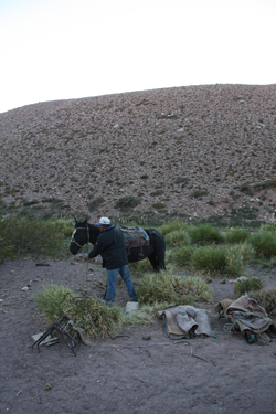 We knew it would be a good walk to the base camp but by the time we finished breakfast it was 9 am and we did not get to walking until about 9:30. In the meantime, we'd watched a slow motion battle between the arriero and one of the mules that really did not want to carry a load up the hill that day. The beast would not come to the loading point and after a few minutes of tugging on a rope, the mule driver had obviously had enough. The reluctant mule found its halter rope tied to two other mules and then cooperation ceased to be a contest between man and mule. Outnumbered, our gear was soon on board and headed upstream. We knew it would be a good walk to the base camp but by the time we finished breakfast it was 9 am and we did not get to walking until about 9:30. In the meantime, we'd watched a slow motion battle between the arriero and one of the mules that really did not want to carry a load up the hill that day. The beast would not come to the loading point and after a few minutes of tugging on a rope, the mule driver had obviously had enough. The reluctant mule found its halter rope tied to two other mules and then cooperation ceased to be a contest between man and mule. Outnumbered, our gear was soon on board and headed upstream.
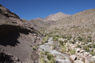
 We knew that this day would be highlighted by river crossings, which we knew the formal trail would do five times. But as we all know, spotting the proper course is always easier on the descent as compared to the hike up hill. Our goal was to stick with the mule track but we soon realized that there were indeed mule tracks, each individually certified by piles of dung, ranging from very old and sun dried to one or two, here and there, that could be tied to a more recent trip . . . sometime that summer? Oh, did I mention the stock that grazes the upper valley without "supervision"? We knew that this day would be highlighted by river crossings, which we knew the formal trail would do five times. But as we all know, spotting the proper course is always easier on the descent as compared to the hike up hill. Our goal was to stick with the mule track but we soon realized that there were indeed mule tracks, each individually certified by piles of dung, ranging from very old and sun dried to one or two, here and there, that could be tied to a more recent trip . . . sometime that summer? Oh, did I mention the stock that grazes the upper valley without "supervision"?
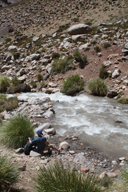
 Before I go on we need to agree on two naming conventions . . . river right and left will be oriented in the direction of travel and X3 means river crossing #3. With these conventions in hand, we stayed on the right bank and knew from Celeste that our first crossing (X3) would be in about 45 minutes, which we figured to be about 0.75 miles as we were going up hill and taking it easy . . . we had a full day in front of us. The course from the camp at X2 to the first crossing at X3 rolled a bit but mostly of flat. Sure enough after about 45 minutes, we crossed a side drainage substantial enough to catch our attention and this was our signal to start thinking about X3. We thought we spotted the place where the trail made the crossing but were not sure so we stuck with river right until a bow of the river ran hard against a cliff, giving us little choice but to make our first crossing. Before I go on we need to agree on two naming conventions . . . river right and left will be oriented in the direction of travel and X3 means river crossing #3. With these conventions in hand, we stayed on the right bank and knew from Celeste that our first crossing (X3) would be in about 45 minutes, which we figured to be about 0.75 miles as we were going up hill and taking it easy . . . we had a full day in front of us. The course from the camp at X2 to the first crossing at X3 rolled a bit but mostly of flat. Sure enough after about 45 minutes, we crossed a side drainage substantial enough to catch our attention and this was our signal to start thinking about X3. We thought we spotted the place where the trail made the crossing but were not sure so we stuck with river right until a bow of the river ran hard against a cliff, giving us little choice but to make our first crossing.
 We dropped the packs and swapped approach shoes and hiking boots for river shoes and Teva sandals. The water was knee deep for the most part and we made the crossing with little trouble or hazard. Each crossing gave us a five minute rest as we took off the river footwear and waited for the feet to dry before putting the socks and dry trail treads back on. We climbed the bluff on river left and there was the mule trail that we would have been on had we crossed a bit earlier. However, the lesson learned is that there really are no spots where the crossing is right there and nowhere else. As we found on our way down ten days later, where combination of water level and river topography grants a crossing spot . . . that is where the crossing is that day. We dropped the packs and swapped approach shoes and hiking boots for river shoes and Teva sandals. The water was knee deep for the most part and we made the crossing with little trouble or hazard. Each crossing gave us a five minute rest as we took off the river footwear and waited for the feet to dry before putting the socks and dry trail treads back on. We climbed the bluff on river left and there was the mule trail that we would have been on had we crossed a bit earlier. However, the lesson learned is that there really are no spots where the crossing is right there and nowhere else. As we found on our way down ten days later, where combination of water level and river topography grants a crossing spot . . . that is where the crossing is that day.
 We were now on river right and we hiked steadily onward and upward through more of the same topography on a steadily climbing trail that never strayed far from the river but which eventually forced us to cross the river at X4 to avoid a stretch of slick rock that would not allow the passage of the mules and which also urged us to make a crossing to hike on trail instead of rock. So it was back down to the river to swap out the footwear and make our way across. The distance from X3 to X4 was about a mile. Once across we knew from Celeste's description that there would be a good size infeeder where we would be able to get clear water as compared to the river water, which would remain a red and muddy affair, unsuitable for drinking day in and out. We were now on river right and we hiked steadily onward and upward through more of the same topography on a steadily climbing trail that never strayed far from the river but which eventually forced us to cross the river at X4 to avoid a stretch of slick rock that would not allow the passage of the mules and which also urged us to make a crossing to hike on trail instead of rock. So it was back down to the river to swap out the footwear and make our way across. The distance from X3 to X4 was about a mile. Once across we knew from Celeste's description that there would be a good size infeeder where we would be able to get clear water as compared to the river water, which would remain a red and muddy affair, unsuitable for drinking day in and out.
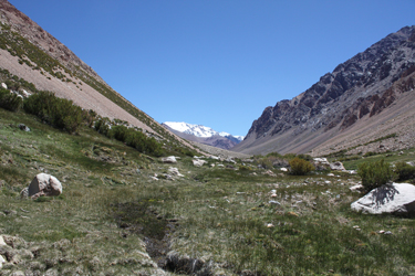
We were now back on river left and we walked about 4/10 mile before coming around a corner and dropping into the drainage of a major side valley. There it be . . . the clear stream Celeste spoke of and for which she warned would have a trail leaving the main river that has proven to confuse other parties. No worries for us however, as Celeste, Manuel and 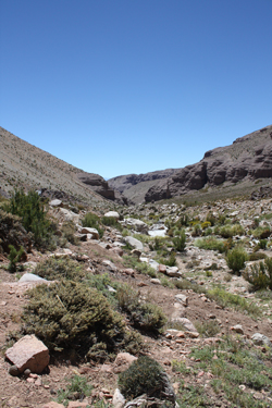 Multi-Presa caught up to us at just that point. We would meet up here and there as our groups had not left at the same time and we were not doing the approach as a single group. We swapped some snacks around and then we started again, knowing that we had about a quarter mile before we would cross the river again. X5 proved to be another non mule crossing for both parties. We both got off the main track and forced crossings about 50 yards apart to gain a steep bank on river right. Multi-Presa caught up to us at just that point. We would meet up here and there as our groups had not left at the same time and we were not doing the approach as a single group. We swapped some snacks around and then we started again, knowing that we had about a quarter mile before we would cross the river again. X5 proved to be another non mule crossing for both parties. We both got off the main track and forced crossings about 50 yards apart to gain a steep bank on river right.
The far bank was covered in undergrowth and had a number of beaten paths that seemed pretty steep for mules but there were sure signs of traffic. After a hundred yards or so, we regained the mule track, left the fleeting riverside green zone behind and once again trod along a desert track. If I recall correctly we passed a number of large boulders, house size large, before walking some flats and then entering a stretch of steep sided canyon before again coming back out onto a much wider gently rising expanse of what had become some hot walking. We knew that we could count on a loss of 3.5 degrees F with each 1000 feet of gain, but the last third of the 1.5 miles or so from X5 to X6 didn't include any chills.
 We came to X6 which is at a slight hook in the river and immediately followed by some grassy slopes with tent pads. This spot is the halfway point from Santa Ana to the Base Camp is sometimes used by groups who are breaking the approach into two full days. We again met up with Celeste and crew and they noted that there was a spring that was perfect for a water bottle fill. It was but for the fact that after I filled my bottle, I noticed a nice 2" diameter mule turd just below my fill point. Well, if water flows downhill and shit rolls down hill, then I guess the stuff in shit doesn't flow upstream. I didn't pour out the water . . . it was just too cool and clear. We came to X6 which is at a slight hook in the river and immediately followed by some grassy slopes with tent pads. This spot is the halfway point from Santa Ana to the Base Camp is sometimes used by groups who are breaking the approach into two full days. We again met up with Celeste and crew and they noted that there was a spring that was perfect for a water bottle fill. It was but for the fact that after I filled my bottle, I noticed a nice 2" diameter mule turd just below my fill point. Well, if water flows downhill and shit rolls down hill, then I guess the stuff in shit doesn't flow upstream. I didn't pour out the water . . . it was just too cool and clear.
The next crossing is not for another 2 miles but the terrain now takes a very different turn. Above the camp spots the desert returns in force as the trail climbs through Utah like red sand and rock before coming to a mound of talus that both man and mule must cross. The game for us was rock hopping but I suspect that if one cuts to the right there is a bit more of a trail for the four leggeds to follow. Once past the talus, the trail climbs up and over a ridge that adds perhaps one hundred feet of 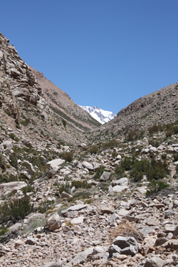 vertical before giving it right back on the other side. Following the very tight and dusty back side switchbacks, the trail enters and climbs up through a substantial canyon. The mile long cleft confines the trail to river right as the river tumbles and falls through rock piles, sloughs and other terrain that would make a class 5 creek boater green with envy. vertical before giving it right back on the other side. Following the very tight and dusty back side switchbacks, the trail enters and climbs up through a substantial canyon. The mile long cleft confines the trail to river right as the river tumbles and falls through rock piles, sloughs and other terrain that would make a class 5 creek boater green with envy.
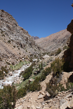
The trail remains steep throughout the climb through the canyon before the upper termination of the canyon reduces the grade for a half mile or so before one again crosses another obvious drainage, again with a flow of clear water suitable for filling water bottles. Once the bottles were topped off, we crossed the creek and descended down a short slope to X7. Once X7 was behind us, the trail again takes to climbing, this time back on river left through a stretch of steep hillside before flattening out onto one of the better sections of mule track. The track leads onward through some boggy areas that seem to host a resident population of cows and horses, likely the rest area for the stock of our arriero. I note this as probably the biggest difference between this part of Argentina and Bolivia is the complete lack of any indigenous population. Nobody lives in this canyon, no huts, now fences, no stone walls, nobody.
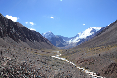
 We crossed the boggy zone through which the river flowed and then worked our way through the grassy zone until we topped a small hill. We now left the desert and canyon hiking behind and entered the world of the mountain valley, talus fans, and guanacos. We descended our last soil covered hill and stepped onto the gravel bar that, this week at least, was not hosting the river that lay about 100 feet to the right. We crossed this couple of hundred yards of gravel flat and then started climbing and rock hopping along a rough trail across a large talus fan draining a side valley. This fan stretched along the valley floor for at least a mile and we easily gained more than a few hundred feet as we traversed the fan and finally came into view of the uppermost stretch of the valley that leads to the base of the south side of Mercedario. We crossed the boggy zone through which the river flowed and then worked our way through the grassy zone until we topped a small hill. We now left the desert and canyon hiking behind and entered the world of the mountain valley, talus fans, and guanacos. We descended our last soil covered hill and stepped onto the gravel bar that, this week at least, was not hosting the river that lay about 100 feet to the right. We crossed this couple of hundred yards of gravel flat and then started climbing and rock hopping along a rough trail across a large talus fan draining a side valley. This fan stretched along the valley floor for at least a mile and we easily gained more than a few hundred feet as we traversed the fan and finally came into view of the uppermost stretch of the valley that leads to the base of the south side of Mercedario.
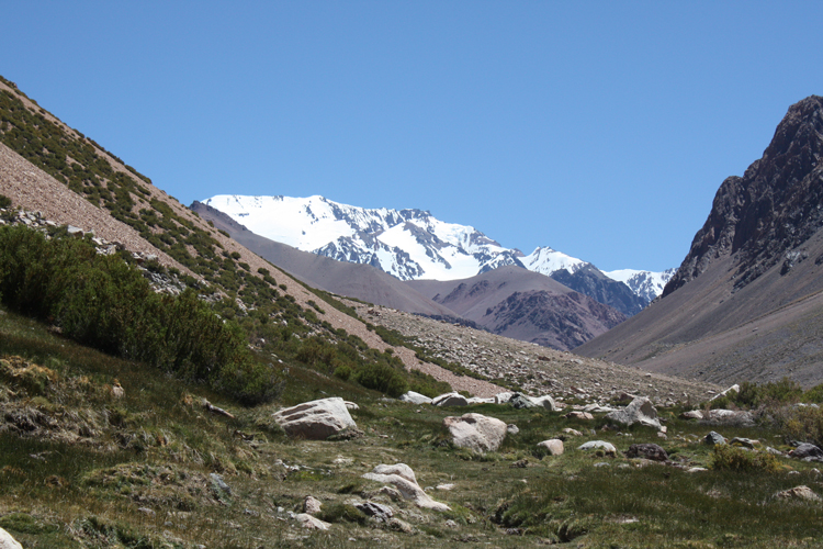
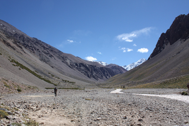 Before us lay Marcedario's south face as well as the snow and ice covered mass of Pico de Polacos. Our goal, Ramada was not in view and we would not see it for another day, but what we did see was some very impressive alpine scenery. As we continued our approach, we were now buffetted by a pretty good wind and the hot portions of the trail were now a distant memory. We were now in second layer territory and though tired, at least I was, we were hiking along at a steady pace to keep the chill away. Now and again I would look at the distance to the base camp on the GPS but after we walked for an hour and seemed to cover no distance whatsoever, I just gave up . . . I knew this had become a mind over matter walk. Once over the fan, the valley widened and through we we a bit of a ways up bank from the river, one could see the wide gravel valley infill and the various courses taken by the Rio Colorado over time. The last portion of the approach was marked by the trail coming down to edge of the gravel bars for the last mile or so to camp. Before us lay Marcedario's south face as well as the snow and ice covered mass of Pico de Polacos. Our goal, Ramada was not in view and we would not see it for another day, but what we did see was some very impressive alpine scenery. As we continued our approach, we were now buffetted by a pretty good wind and the hot portions of the trail were now a distant memory. We were now in second layer territory and though tired, at least I was, we were hiking along at a steady pace to keep the chill away. Now and again I would look at the distance to the base camp on the GPS but after we walked for an hour and seemed to cover no distance whatsoever, I just gave up . . . I knew this had become a mind over matter walk. Once over the fan, the valley widened and through we we a bit of a ways up bank from the river, one could see the wide gravel valley infill and the various courses taken by the Rio Colorado over time. The last portion of the approach was marked by the trail coming down to edge of the gravel bars for the last mile or so to camp.
 At this point Manuel and Celeste caught up with us, as we were out front for the last four miles or so. One of them had cooking on the mind and I think they all decided to add a notch of throttle lest the Yankees arrive at the base camp before the cook. Bob, however, was showing his famous competitive streak and as they passed, he joined the back of their group, not allowing them to arrive at camp before any of us. They finally broke into a virtual jog but Bob did not drop off and the four of them powered into base camp at perhaps a few minutes before 6 in the evening. G and I joined them about 5 minutes later, arriving just a minute after 6 p.m. At this point Manuel and Celeste caught up with us, as we were out front for the last four miles or so. One of them had cooking on the mind and I think they all decided to add a notch of throttle lest the Yankees arrive at the base camp before the cook. Bob, however, was showing his famous competitive streak and as they passed, he joined the back of their group, not allowing them to arrive at camp before any of us. They finally broke into a virtual jog but Bob did not drop off and the four of them powered into base camp at perhaps a few minutes before 6 in the evening. G and I joined them about 5 minutes later, arriving just a minute after 6 p.m.
 The course from the Approach Camp to the Base camp covers a distance of about 12 miles and took us 8.5 hours to cover. We ended up doing all five river crossing and we generally had decent trail for most of the way. The day went from a desert hike to a hike along a braided glacial stream in a high mountain valley. We got sun, we got wind but in the end we got to the base camp in good time . . . perhaps the result of our homes being located at an elevation of 6000 feet. The course from the Approach Camp to the Base camp covers a distance of about 12 miles and took us 8.5 hours to cover. We ended up doing all five river crossing and we generally had decent trail for most of the way. The day went from a desert hike to a hike along a braided glacial stream in a high mountain valley. We got sun, we got wind but in the end we got to the base camp in good time . . . perhaps the result of our homes being located at an elevation of 6000 feet.
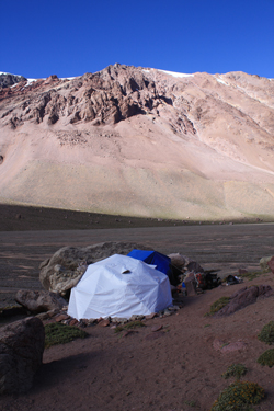
Once in camp, we noted that Anibal had every bit of a set up that we could ask for. Celeste and Manuel had a cook tent tucked nicely into a boulder pocket and next door was a 15 foot diameter geodesic dome tent, complete with table and chairs . . . all the comforts of home and a far cry from the teepee tents we were used to in Bolivia and Peru. We set up our tents in another boulder pile, using tent pads that were originally constructed by he Polish expedition that arrived in this spot in 1934 and scored the first ascents of all the peaks in the Ramada Range. Their pads were well sited, the wind was blocked and we had one very comfortable base camp. Celeste and Manuel covered dinner that evening and with stomachs full of good food, we all called it a night after a long day's hike.
|
