|
||||||||||||||||||||||||||||
|---|---|---|---|---|---|---|---|---|---|---|---|---|---|---|---|---|---|---|---|---|---|---|---|---|---|---|---|---|
Banff Assiniboine Expedition IIApproach to Assiniboine – August 6, 2003
|

|
Our ride into Assiniboine Park |
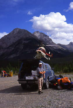
We got up the next morning in the fast hustle mode as we needed to determine if the Assiniboine climb was still on or if the encroaching fires had stopped either our access to the park or our route out via Banff National Park. A trip to the Banff National Park visitor center in determined that Assiniboine Provincial Park was open, that our Banff permit would be honored but that the backcountry permits system was shut down and the Park was letting the trails and campgrounds “drain out.” Translation – we were off to Assiniboine and had just an hour or two to pack before heading for the Mount Shark helipad 25 miles outside of Canmore. Our next stop was the Safeway for food, then the campground to break camp and get our gear ready for the climb and finally on to Gear Up to drop off Ed’s rental boots. With those tasks completed, we took the dirt road south to Mount Shark and our helo ride into the road-less Assiniboine Provincial Park.
|
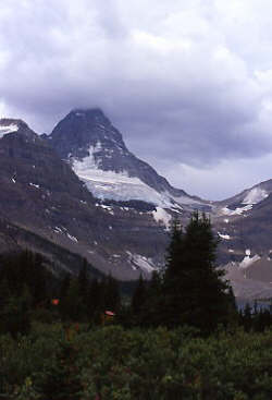
Mount Assiniboine from Assiniboine Lodge |
The helicopter used for the Assiniboine shuttle is also one of many used to bucket drop water on the fires so we were told to be at the pad a bit early as they wanted to get the Lodge and climber shuttles done before the afternoon heat really built up. We checked in with the crewman and our packs were weighed to ensure that they either were under the 40 lb limit or that we were properly charged for the overweight amount. We came in about 9 lbs over for the three of us ($7 extra fee) and took our place along the side of the gravel pad for a later flight. Our turn came soon enough and we climbed aboard the Jet Ranger with three other folks for the ride into the Assiniboine Lodge. The other group of three was a father/son pair being guided by Barry Blanchard from Yamnuska Mountaineering and if nothing else, this was a sign of at least three climbers on the mountain who would have the wherewithal to go easy on the rocks and the common sense to yell out when they set one loose.
|
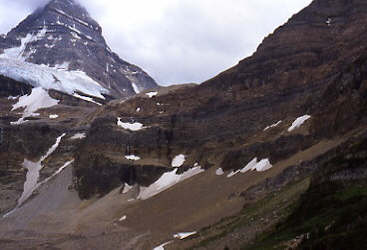
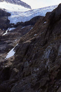
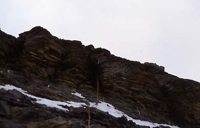
Gmoser’s Highway climbs the headwall to the hanging valley above |
The helicopter ride is a rush for all but those seriously scared of heights and takes about 10 minutes to make the run up the Bryant Creek drainage and over the top of Assiniboine Pass. They dropped us off on the hill behind the Assiniboine Lodge and we gathered our gear for the semi challenging approach to the mountain. The Assiniboine climb may be made directly from the Lodge but most prefer to do the Gmoser Highway approach on the first day and then, after an overnight at the Hind Hut, climb the peak the following day if the weather allows. This was our plan and we had reserved space in the hut for three nights to assure sufficient time to get in at least one attempt on the peak. The weather report was positive and things were looking up as we began our trek around the lake and up the headwall atop which the peak and hut are located.
|
Start of the approach up the headwall |
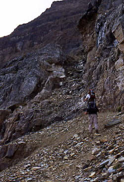
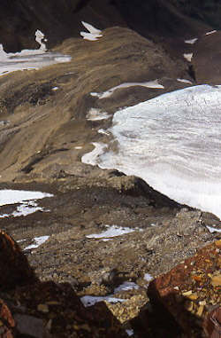
The Gmoser Highway is a trail that cuts the headwall and to call it a highway is . . . a bit of an overstatement. The truth of the matter is that it is one of the more challenging parts of an Assiniboine climb, not so much from a difficulty viewpoint as from an exposure angle. While most of the route is a scramble route along an easily identifiable route, there are sections where the trail thins and a misstep will result in a fatal drop. I would rate the approach exposure to be as much as the tougher sections on the harder Colorado 14’ers, except we generally did not climb those 14’ers with 40+ pound packs as is the case here. We took the standard approach along the lake, through the campground and on up the first two slot pitches that lead to the main portion of the route. Next the trail traverses along the cliff bands, climbing here and dropping there but generally presenting multiple narrow spots, each located above a slope leading directly (you would get a bounce or two) to the moraine far below. After traversing the ledges, we climbed the short snow slope to the braided trail leading to the upper moraine covering the base of the hanging valley atop the headwall. Though not much of a challenge, this meandering 2 steps up/ 1 slide down is a true pain in the ass and presents ample opportunity for any group ahead to bean those lower with ready to go loose rocks.
|
Route crosses ledges to the base of the far snowfield |
Once atop the headwall, we wandered up the moraine to the Hind Hut, which is located atop a bluff of black rock jutting prominently from the surrounding snowfield. There was one group of two ahead of us and another three climbers who had climbed the peak that day and were overnighting before heading down the next day. We dropped the packs outside and went in to claim spots on the sleeping shelves and get some lunch going. We did not know if we would climb the next day or take a rest day but we did know that with the Aberdeen climb the day before and the three hour climb to the hut, we would have to get on the eating and hydration track to have the energy needed for the next day if it was to be an option. A generous portion of cheese and summer sausage on bagels and then a few hours filled the bill later by Ramen soup and a few quarts of Cytomax. We also took time to decide if we would climb the next day and came to the conclusion that we would give it a shot. We did however have some concerns. Ed had had a difficult trip up Gmoser’s and was not sure of his enthusiasm for the more exposed sections further up on the peak while Gary was nursing a sore ankle, the result of our over extended belays on the steeply angled ice of Mount Aberdeen. As for me, I was tired, not looking forward to a sweltering night in the hut, and nursing a less than positive attitude.
Mount Assiniboine – August 7, 2003
(Northeast Ridge – Class 5.5)
|
A sunrise break at the base of the red band |
The decision was made to take a shot at the climb the next day to give us multiple climbing opportunities, to take advantage of good weather, and to avoid the interminable waiting associated with any rest day at an alpine hut (boredom). The alarm went off at 3 a.m. and we mulled over whether to get up and go. I’d answered the call of nature an hour earlier and knew that the sky was about half cloud but that there was no wind and it was warm. We got up, ate a bite of breakfast, and headed down the moraine for the climb up to the base of the peak on the other side. Gary did not like the feel of his ankle and after about 10 minutes made a call to return to the hut. We stopped as a group and discussed whether to turn the group as a whole or whether Ed and I would continue the climb. The major concern for Gary was that our retreat from Assiniboine Park was to be on foot and that the distance from the hut to the car was a 20-mile hike with a pack. Combining that with a full day on Assiniboine and the need to get safely down Gmoser’s, just did not come together as a good overall plan. G turned for the hut and Ed and I continued toward the peak though I entertained little enthusiasm after the loss of one member of the group.
|
Our red band pitch - about a 50 foot lower class 5 climb |
Ed and I struggled up the far moraine, still in the dark and navigating by shadows more than anything else, until we reached its apex and found the trail that leads to the first pitch of the climb. Assiniboine is composed of obvious bands of rock and perhaps the first half of the climb is simply a scramble up to an obvious red band that forms the first technical climbing of the route. The scramble from the moraine is pretty continuous and covered in loose rock, making a climb as the second group, a semi hazardous adventure. We knew that there would be another group of two behind us but that they would likely trail by no less than two hours. Our progress was slow but steady as I picked out the route by the light of my headlamp until dawn finally broke. By that time, we were nearing the obvious buttress that forms a flat bench below the scramble leading to the base of the red band. This was a good spot to stop, eat, drink, and most importantly assess Ed’s comfort level with the terrain covered so far on the climb. We were still “good to go.”
|
Our brief first view of the summit |
The next major obstacle was the red band that Gary and I had climbed the previous year but not proceeded beyond its top. Ed and I looked over the various ascent options and found one that looked easier than the earlier route. We broke out the rope and rock gear to make the climb. We were carrying a light rock rack composed of nuts, tri-cams, and a single cam along with the 8.1 mm rope we had for glacier travel. Given the small diameter of the rope, we climbed using a doubled line and placed ample protection to limit the fall distance. I took the lead and with Ed on belay, quickly surmounted the red band without any trouble. There was a secure rappel station at the top and within a few minutes Ed had joined me atop the first technical pitch of the climb. Above the red band, we followed an ascending trail that took a diagonal course toward the ridgeline proper. From reading other reports and talking with climbers, we knew that the ridgeline was the best route and that we could anticipate trail segments and belay stations as long as we stuck to the main travel path. We climbed and scrambled higher, bringing us to the next technical pitch, the gray band.
|
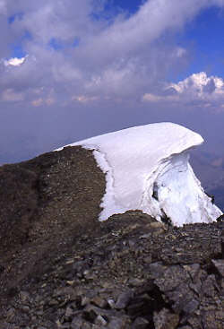
Summit ridge cornice |
I mentioned earlier that we are not traditional rock climbers and leading 5.5 is new to me, therefore with little shame, I’ll admit that the gray band pretty much stopped us for about 15 minutes. We found a secure piton so the start of the climb was clear but then I took two false leads before returning to the base for third and successful try. In the meantime, the other group had caught up with us and subsequently played through our position with nary a word. Lets just leave my comments about the leader of this group as a combination of “expletives deleted” and the fact that he had no mountaineering class, in the hut or on the peak. Crying shame was that they were also from the US and his manner left much to be desired as far as making an impression among the Canadians and other foreign climbers we had the pleasure of sharing this peak with.
|
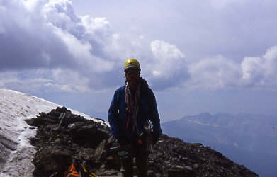
Second try guy on top |
I completed the move through the gray band and again brought Ed up using a secure belay station atop this 50 to 60 foot section. However, at this point, Ed and I had another comfort call to make as we both knew that a major slip or slide would have serious consequences and that the extended use of belayed pitches would also extend the time needed for the climb well toward the full day mark. We decided to go on so I began leading out the rope, placing intermediate protection and bringing him in on good belays. We continued this routine for another pitch or two until the terrain moderated a bit and we simul climbed with protection being placed along the way.
|
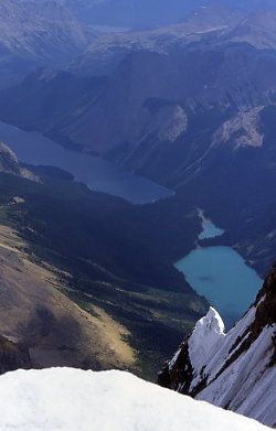
Lakes in the valley below |
Our next hurdle was the obvious cleft that guards a final scramble to the summit ridge. Now bear in mind, we have yet to see the summit as the fog came in on us at the top of the red band and we were climbing on memorized waypoints from our prior readings and observation of the peak the prior afternoon and during the previous year’s attempt. Finally, as we looked over the abyss of the east face and scoped out what we hoped would be our last technical section, the summit came into view, still perhaps 200 feet higher and accessed by a sweeping ridge. The cleft seemed to be the biggest challenge so far but once we arrived at its base, we could see that it too was within our abilities and that we could make a belayed climb up and over the steep ground to the scramble beyond. I lead and again brought Ed in, and then we repeated the simul climbing process and another belayed pitch to gain the summit ridge.
|
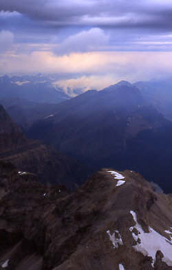
Fires two valleys over |
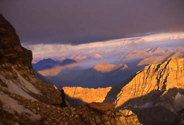
The summit ridge is a walk along the edge of the east face on a few foot wide path or one can drop off to the west a few feet and scramble the side slope. We took the airy walk in some places and the slope in others, regardless being a bit on the careful site when exposure was an issue (generally the case). After no more than ten minutes, we stepped to the high point and with perhaps a bit of surprise, we’d topped out on Assiniboine. The clouds had broken but the threat of others inbound gave us reason to sign the register, down a power bar and snap some photos without a great deal of delay. It was now 1 p.m. and we had been climbing for 9 hours.
Our descent promised to be an easier affair, at least through the technical sections as prior climbers had installed solid rappel stations or sufficient slings to allow the technical sections to be rappelled. We made a belayed down climb from the summit ridge to the top of the cleft move and set a 70-foot rappel to a flat spot below. Coincidentally, the threatening clouds also arrived at the same time and began to alternatively dump ¼” ice pellets or big snowflakes on us as we rigged the drop and made our way down the first pitch. In the interest of time, we simul-climbed down the steep scramble to the next rappel station atop a rounded stone runnel that lies a few hundred feet atop the gray band. Another full length (doubled 60 m rope) rappel to the next station and then another landed us atop the gray band.
|
Ed rappels the gray band |
The gray band fell to another rappel as the ice and snow lightened up for our traverse down to the top of the red band, not that we could see it in the heavy cloud hanging on top of the peak. But, I knew that once we cleared the gray band, we were home free and that the red band represented the start of territory I had already climbed through three previous times. We took trail segments and scrambles down to the top of the red band and located a suitable rappel station (there are more than a few to choose from) from which to make another full rope rappel to the base of this last technical pitch. Ed and I safely landed below and took a well-deserved break as the clouds lifted and fell, sometimes exposing the hut on the moraine far below. From this point down, the name of the game was keeping the knees untwisted and taking one’s time on the steep slopes leading down to the buttress and beyond. We made steady but cautious time down the rocky slope, taking care as what fell as snow on us above, had wetted the rock as rain at the lower elevations. Eventually, and more than a bit tired, we arrived at the top of the entry scramble and dropped down onto the trail at the top of the moraine leading down to the floor of the hanging valley. We had scored Assiniboine.
|
On rappel at the top of the red band |
The trip across the valley is a scree ski down and talus climb up to the hut. Gary met us near the crest and announced that it was 6:30 p.m. and that we had completed yet another Canadian “full day” climb. I realize of course that Assiniboine is generally not a 14½ hour affair and that most parties likely use less protection on the high scrambles above the gray band but after two long climbs earlier in the week and a tough night in the hut, we played it safe to ensure future climbing opportunities. We were also handicapped to some extent by the lack of cams and the use of a doubled rope, the provision of which would likely have cut no less than three hours off our ascent. Live and learn . . .
We made dinner in the hut and discussed the plan for the next day, climb, hike, or helo. Gary’s foot was better but we still needed to look at this issue of timing. If we got up early the next morning, we could traverse Gmoser’s and catch a helo out, negating the possibility of a sore ankle turning a 20-mile hike into a heavy pack death march. Alternatively, we could take a second shot at Assiniboine the next day, miss the helo opportunity and have to walk out regardless of injuries. In the end, the best decision was to retreat with an ankle on the up tick than take the risk of further injury on a climb that will remain for future seasons. It was a tough call and I for one felt badly that we did not get the entire group up Assiniboine but we have also climbed together enough to realize that climbing is more than the summit, it is the overall challenge and camaraderie of the trip that makes the entire venture a success.