Grizzly Peak Attempt & Summit
February 16, 2008 - Attempt via Loveland Pass
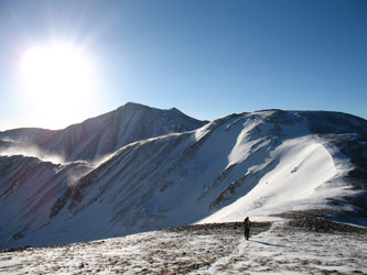
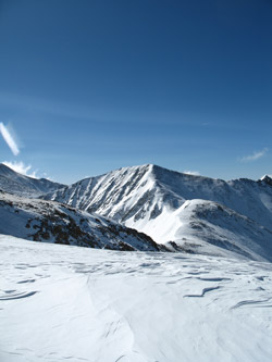
The National Weather Service zone forecast had bluebird day written all over it and we were going to get out and enjoy it. We left Cheyenne at 3 a.m. and arrived at the parking area atop Loveland Pass at 6 o'clock. There was no sign of dawn so we kept the heater going and dozed for a half hour to await enough light to make there determination whether we were putting on double plastic boots or ski boots and if it was the former, were we taking snow shoes. By 6:45 we knew the answer and that was that there was not sufficient snow on the long ridge route for anything but double plastic boots alone. We put on the boots and grabbed our packs. This mountains were absolutely packed with snow but this ridge obviously sees enough wind to leave it bare throughout the winter.
 At this point in our climbing careers we've adopted to the "go light" theory of mountain travel but with that choice comes the risk of failure due to perhaps even a small change in weather or one piece of gear accidentally left in the car. The risk for this climb would lie in a change of the weather from the predicted blue skies and light winds to anything less favorable. We climbed atop the roadside snow bank and headed on up the first slope that leads to the knob separating Mt. Snikatu in one direction from the gently humped ridge leading to Grizzly Peak in the other. We made a steady pace talking to two other climbers who were also headed for Torreys via this long and exposed route. Conversation with the others came easily as they were at about the stage in their climbing careers where we were just before our first trip to South America. We talked of the difference in climbing above the 14k we are accustomed to and the best way to get a safe introduction to glacier travel before a trip to Mt. Rainier. At this point in our climbing careers we've adopted to the "go light" theory of mountain travel but with that choice comes the risk of failure due to perhaps even a small change in weather or one piece of gear accidentally left in the car. The risk for this climb would lie in a change of the weather from the predicted blue skies and light winds to anything less favorable. We climbed atop the roadside snow bank and headed on up the first slope that leads to the knob separating Mt. Snikatu in one direction from the gently humped ridge leading to Grizzly Peak in the other. We made a steady pace talking to two other climbers who were also headed for Torreys via this long and exposed route. Conversation with the others came easily as they were at about the stage in their climbing careers where we were just before our first trip to South America. We talked of the difference in climbing above the 14k we are accustomed to and the best way to get a safe introduction to glacier travel before a trip to Mt. Rainier.
 Once we topped the first knob the wind arrived in force. What had been a great ridge walking day with no sign of plumes from the far summits had turned, in just a few minutes, into a howling wind day. The gusts were likely up around 50 mph and the wind itself was sustained at 40 mph or so. The ambient temperature was about 15 degrees and the wind borne ice particles were cutting through our light face masks. We trudged on toward Grizzly but took a break once reached the rounded crest of the point known at Mt. Cupid at an elevation just over 13,100 feet. It was decision time . . . the nose was numb on one side, down jackets were coming out of the both packs and we had a long long way to go. We turned the climb. Once we topped the first knob the wind arrived in force. What had been a great ridge walking day with no sign of plumes from the far summits had turned, in just a few minutes, into a howling wind day. The gusts were likely up around 50 mph and the wind itself was sustained at 40 mph or so. The ambient temperature was about 15 degrees and the wind borne ice particles were cutting through our light face masks. We trudged on toward Grizzly but took a break once reached the rounded crest of the point known at Mt. Cupid at an elevation just over 13,100 feet. It was decision time . . . the nose was numb on one side, down jackets were coming out of the both packs and we had a long long way to go. We turned the climb.
Fast and light brings its risks of failure, winter adds an additional factor and age and experience bring the whole equation together. Going light brings its own special risks and if the weather should deteriorate further, the trip out would have been sheer misery. The route will be there later in the year, or another year, and we will come back for another try. This time however the better part of valor lay in a comfortable retreat that even included an extra mile of recon hiking toward Snikatu before we reversed and cut down the ridge to the crest of Loveland Pass.
April 14, 2008 - Summit via Loveland Pass
 Two months before G and I made an attempt on Grizzly Peak but to no avail. This weekend G was in the sunny warmth of Florida and I was giving thought to getting in shape for our upcoming trip the Mt. Rainier and other Cascade peaks. I don't do as much solo climbing these days as I once did . . . it simply is not as much fun without someone else along for the ride, the climb, and the post climb meal. Regardless, I knew that I had to score some time on the trail and I had to log some time above 13k as well. Taking a second shot at Grizzly seemed like a good idea as the weather forecast said that Sunday would be the first day of a significant warming trend and that the wind would die off with the arrival of a high pressure system over the mountains. Two months before G and I made an attempt on Grizzly Peak but to no avail. This weekend G was in the sunny warmth of Florida and I was giving thought to getting in shape for our upcoming trip the Mt. Rainier and other Cascade peaks. I don't do as much solo climbing these days as I once did . . . it simply is not as much fun without someone else along for the ride, the climb, and the post climb meal. Regardless, I knew that I had to score some time on the trail and I had to log some time above 13k as well. Taking a second shot at Grizzly seemed like a good idea as the weather forecast said that Sunday would be the first day of a significant warming trend and that the wind would die off with the arrival of a high pressure system over the mountains.
 I set the alarm for 4 a.m. to facilitate a 4:15 departure but getting out of that warm bed just did not make sense. It seems like I am always struggling between the alpine start that I know is necessary and the torment of serious cold and no sun in the morning. As this was not to be a spring snow climb where the temps were expected start the rocks to fall and the snow to really rot out, I reset the alarm to buy another hour of sleep. I knew dawn would be much earlier than our last trip but I was kind of hoping for some sun right from the trail head. I left by 5:15 and arrived at the Loveland Pass parking area just a bit before 8:00. I was dressed to climb from the start so I did little more than smear on some sun screen and change from my hiking boots to my double plastics. I looked at the slopes and decided to skip the snowshoes but as I was solo, I had an extra layer and some additional survival gear in the pack. I set the alarm for 4 a.m. to facilitate a 4:15 departure but getting out of that warm bed just did not make sense. It seems like I am always struggling between the alpine start that I know is necessary and the torment of serious cold and no sun in the morning. As this was not to be a spring snow climb where the temps were expected start the rocks to fall and the snow to really rot out, I reset the alarm to buy another hour of sleep. I knew dawn would be much earlier than our last trip but I was kind of hoping for some sun right from the trail head. I left by 5:15 and arrived at the Loveland Pass parking area just a bit before 8:00. I was dressed to climb from the start so I did little more than smear on some sun screen and change from my hiking boots to my double plastics. I looked at the slopes and decided to skip the snowshoes but as I was solo, I had an extra layer and some additional survival gear in the pack.
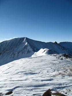
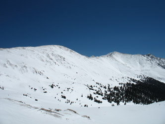
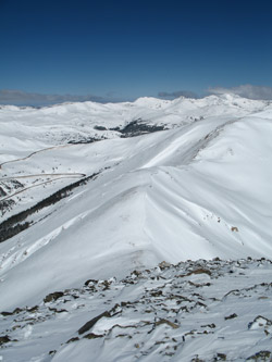
 I left the parking lot and had to fight the wind and the temperature right off the bat. The wind was not too bad, perhaps 15 to 20 mph but the temp was down around 16 degrees. I knew it was supposed to warm up but I did not have 500 feet of vertical before the glove liners were replaced by the minus 20 degree glacier gloves, another layer went under the parka and the hood was up as the wind was really biting my cheeks. The last trip produced a certified case of frostbite on G's nose . . . I did not need a big black scab on mine this time around. I climbed to the first crest I left the parking lot and had to fight the wind and the temperature right off the bat. The wind was not too bad, perhaps 15 to 20 mph but the temp was down around 16 degrees. I knew it was supposed to warm up but I did not have 500 feet of vertical before the glove liners were replaced by the minus 20 degree glacier gloves, another layer went under the parka and the hood was up as the wind was really biting my cheeks. The last trip produced a certified case of frostbite on G's nose . . . I did not need a big black scab on mine this time around. I climbed to the first crest 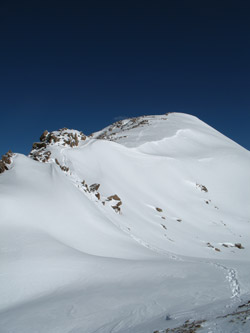 and tried to cut some elevation gain off by contouring around to the first saddle. However, both times, I looked to cut off some distance, I was confronted with an avalanche starting zone where there had been none two months before. The front range had picked up about 42 inches of snow over the past week and the avalanche conditions were rated as considerable. The new snow had extended the avi paths up to the ridge line proper . . . there were no short cuts this time. and tried to cut some elevation gain off by contouring around to the first saddle. However, both times, I looked to cut off some distance, I was confronted with an avalanche starting zone where there had been none two months before. The front range had picked up about 42 inches of snow over the past week and the avalanche conditions were rated as considerable. The new snow had extended the avi paths up to the ridge line proper . . . there were no short cuts this time.
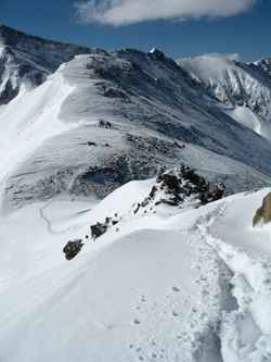
I dropped to the first saddle and stayed on the trail of the two climbers I knew were ahead of me. I'd seen them outlined against the early morning skyline and came to the conclusion they were not new to the game as their prints took the path of least elevation gain 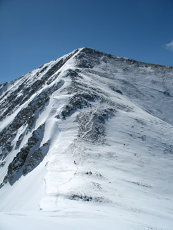 and resistance. The leader was a contouring pro and wasted no energy with extra steps. I contoured along the side of Cupid and looked down the drop that leads to one intermediate ridge bump and then on up the slope to the summit of Grizzly Peak. The drop to the post Cupid saddle was snow loaded but a gentle grade but for one sneak move down and around a rock outcropping. I took their beaten path but upon looking back could see that the path skirted right along the edge of a nice little avi starting zone. I'd been looking at slopes of all orientation and seen no sign of movement anywhere around the pass and it was still real cold and early . . . and resistance. The leader was a contouring pro and wasted no energy with extra steps. I contoured along the side of Cupid and looked down the drop that leads to one intermediate ridge bump and then on up the slope to the summit of Grizzly Peak. The drop to the post Cupid saddle was snow loaded but a gentle grade but for one sneak move down and around a rock outcropping. I took their beaten path but upon looking back could see that the path skirted right along the edge of a nice little avi starting zone. I'd been looking at slopes of all orientation and seen no sign of movement anywhere around the pass and it was still real cold and early . . .
I cleared that obstacle and upon looking back decided that on the return I'd skirt to the west side of the outcrop to avoid that one piece of trail on the way back to the trail head. I continued on down, across the second saddle and up the last bump before the last saddle of 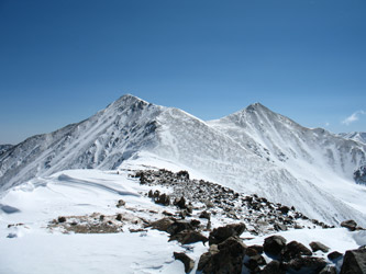 the trip. The route had substantial more snow than last time but most had been wind hammered, obviating the need for the snow shoes I left in the car. I topped the next hump and came upon the second of the two fellows ahead of me. He was putting his snow board on for the slope down to the last saddle and we chatted briefly. He was soon off, leaving me to decide if the climb would now turn due to the slope before me or if I could connect two patches with some rock and vegetation poking through to make it down to the saddle. the trip. The route had substantial more snow than last time but most had been wind hammered, obviating the need for the snow shoes I left in the car. I topped the next hump and came upon the second of the two fellows ahead of me. He was putting his snow board on for the slope down to the last saddle and we chatted briefly. He was soon off, leaving me to decide if the climb would now turn due to the slope before me or if I could connect two patches with some rock and vegetation poking through to make it down to the saddle.
I made the connection and got to the saddle but there was more snow between the patches than I anticipated. In hindsight, the climb 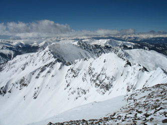 probably should have turned at that point but as I was now across, I figured I'd take a shot at the summit as I had to recross the one iffy spot, summit or not and it was still really early temperature wise. The climb to the summit gains perhaps 500 or 600 vertical feet and I tracked along behind the second boarder for perhaps half the gain. He was bushed and honestly, I was too. The climb has a hump, then a flat, and then a hump, so I wished him well at the mid grade flat and took a more direct route to the summit. They were not summit bound but instead headed to a chute leading down to the A Basin ski area. probably should have turned at that point but as I was now across, I figured I'd take a shot at the summit as I had to recross the one iffy spot, summit or not and it was still really early temperature wise. The climb to the summit gains perhaps 500 or 600 vertical feet and I tracked along behind the second boarder for perhaps half the gain. He was bushed and honestly, I was too. The climb has a hump, then a flat, and then a hump, so I wished him well at the mid grade flat and took a more direct route to the summit. They were not summit bound but instead headed to a chute leading down to the A Basin ski area.
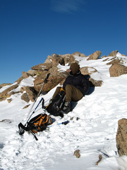
 I climbed on and after another 15 minutes or so I reached the summit. The wind that had fallen to a gentle and hardly noticeable breeze came up as I reached the top, a sign from Pachamama that I had been permitted the summit but that I should not linger any longer. I took the hint and started back down. being solo, I took my time with the footing and retraced my path down the rocky slope. I reached the saddle and gingerly traversed back along my route and soon reached the rocky portion of the slope. I was not really that worried about the slope but I did not wish to spend any more time on the snow than necessary. I made the top of the first bump and broke for a Goo and some Cytomax. Over the top and down the gentle back side . . . then I was back at the other avid spot I had encountered on the way in. I traversed west a few yards and took to the class 3 outcrop and in just a few minutes bypassed that short stretch. I climbed on and after another 15 minutes or so I reached the summit. The wind that had fallen to a gentle and hardly noticeable breeze came up as I reached the top, a sign from Pachamama that I had been permitted the summit but that I should not linger any longer. I took the hint and started back down. being solo, I took my time with the footing and retraced my path down the rocky slope. I reached the saddle and gingerly traversed back along my route and soon reached the rocky portion of the slope. I was not really that worried about the slope but I did not wish to spend any more time on the snow than necessary. I made the top of the first bump and broke for a Goo and some Cytomax. Over the top and down the gentle back side . . . then I was back at the other avid spot I had encountered on the way in. I traversed west a few yards and took to the class 3 outcrop and in just a few minutes bypassed that short stretch.
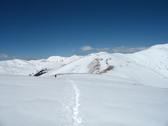 The top of the slope was the summit of Cupid and from there on down, there was just a ridge walk with but a short low angle snow field between me and the top of the first rise, albeit still about 1/2 mile from the parking area. It topped that rise and leisurely walked down to the car, now located in the full up Loveland Pass parking area. The top of the slope was the summit of Cupid and from there on down, there was just a ridge walk with but a short low angle snow field between me and the top of the first rise, albeit still about 1/2 mile from the parking area. It topped that rise and leisurely walked down to the car, now located in the full up Loveland Pass parking area.
|
