-
Mt. Bierstadt Group Summit - Front Range, Colorado
-
A rest before the summit push on Dallas Peak - San Juan Range, Colorado
-
Broken Ankle + 6 Miles = Tired
-
The classic San Juan approach - San Juan Range, Colorado
-
Overlooking Noname Basin from Twin Thumbs Pass - San Juan Range, Colorado
-
Upper Noname Basin - San Juan Range, Colorado
-
Nearing Noname Cabin - San Juan Range, Colorado
-
Twin Thumbs Twins - San Juan Range, Colorado
-
Nearing the summit of Pt. 13,736 - Sawatch Range, Colorado
-
Blustery day on Iowa Peak - Sawatch Range, Colorado
-
Morning snow at 15k, Cerro Ramada - Cordillera Ramada
-
Artesonraju from the summit of Nevado Pisco - Cordillera Blanca, Peru
-
February crowds on Gray's Peak - Front Range, Colorado
-
Kicking steps on Cerro Lliani - Cordillera Vilcanota, Peru
-
Final traverse to the summit of Wheeler Mountain - Ten Mile Range, Colorado
-
The long walk to Pachanta - Cordillera Vilcanota, Peru
- banner31
Afternoon at 17k on Cerro Ramada - Cordillera Ramada, Argentina
- banner22
The final ridge on Iowa Peak - Sawatch Range, Colorado
-
Summer summit on Longs Peak - Front Range, Colorado
-
A rest day at the Pachanta Hot Springs - Cordillera Vilcanota, Peru
-
Mind over matter on Mt. Parnassas - Front Range, Colorado
-
Rest stop on Cerro Lliani - Cordillera Vilcanota, Peru
- banner30
Post nap surprise on Cerro Ramada - Cordiller Ramada, Argentina
-
Summit on Cerro Lliani - Cordillera Vilcanota, Peru
- banner23
Ridge walking on Grizzly Peak - Sawatch Range, Colorado
-
Enroute the summit via the West Ridge on Pacific Peak - Ten Mile Range, Colorado
-
Mule train bound for Chilca - Cordillera Vilcanota, Peru
-
Taking in the view from Fletcher Peak - Ten Mile Range, Colorado
-
Hiking on Silverheels - Mosquito Range, Colorado
-
Traversing! Gladstone Peak - San Juan Range, Colorado
- banner24
The best of times at Willow Lake - Sangre de Christo Range, Colorado
- banner29
High Altitude Cerebral Edema? - Cordillera Ramada, Argentina
-
Bound for Chilca - Vilcanota Range, Peru
-
Going alpine light, Holy Cross Ridge - Sawatch Range, Colorado
-
Cumbre! Campa I - Cordillera Vilcanota, Peru
-
Roadside lunch with the best of company - Cordillera Vilcanota, Peru
- banner25
Long ridge walk to the summit of California Peak - Sangre de Christo Range, Colorado
- banner28
Crossing el Rio Colorado . . . in the afternoon - Cordillera Ramada, Argentina
- banner37
Dealing with Fall snows high on Casco Peak - Sawatch Range, Colorado
-
Moonrise over Mercedario - Cordillera Ramada, Argentina
-
Still climbing at 20,900 on Cerro Ramada - Cordiller Ramada, Argentina
-
Talus on Halo Ridge, Mt. of the Holy Cross - Sawatch Range, Colorado
- banner26
Deteriorating conditions on Mt. Arkansas - Ten Mile Range, Colorado
- banner27
After the climb - Cordillera Ramada, Argentina
- banner38
Taking in the view from the summit of Crystal Peak - Tenmile Range, Colorado
-
Topping out on Mt. Arkansas' North Couloir - Mosquito Range, Colorado
-
Glissade on Mt. Arkansas - Mosquito Range, Colorado
-
Hard snow morning on Teakettle Mountain - San Juan Range, Colorado
-
Spring snow announces the start of the climb on Dallas Peak - San Juan Range, Colorado
-
Crossing the Eolus Catwalk - San Juan Range, Colorado

 I'd picked Bull Hill because my ankle was still on the mend and I knew that most of the climb would be on old mining roads and what was not on old roads would be class one hiking for sure. It had been 11 weeks or so since the break and there were still some aches and swelling to be dealt with and I'm really trying to avoid cranking the foot if I don't have to.
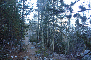
 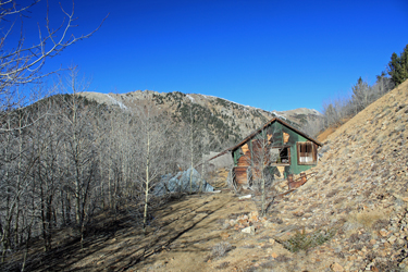 The trail crossed the creek and followed an old mining road uphill, which didn't last too long. After no more than 200 yards, the road died and an obvious trail took a hard right, heading steeply uphill. Steep enough to be one of those "Oh Jeez" moments at the start of the hike where the going gets steep right out the gate and you don't really want to go steep that early in the climb. Well, there was no choice , so I climbed the single track path that traversed the flank of Echo Canyon, staying above the creek but not by too much. I hiked perhaps one half mile before the trail cut right again, granting me the opportunity to start climbing the multiple switchbacks that the map clearly advertised
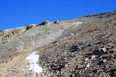 The first traverse was long but just when I was wondering if I would get a trip around the flank of the mountain, it cut back hard and steadily climbed back in the opposite direction. I knew at some point I would have to cut right again and leave the Echo Canyon trail so when I came to a trio of cairns, I knew that somebody was talking to me for sure. The cut right was obvious, so I took the trail headed in what I knew to be the right direction, although the trail was a bit on the sparse side as it cut in and out of pine trees doing their best to obscure the old mining road that I was still ascending. The pines petered out after a bit and I hiked steadily to tree line, and coming next to the Last Chance Mine fan house. I stuck my head in the door, took in the old machinery and shot a GU before heading further up hill.
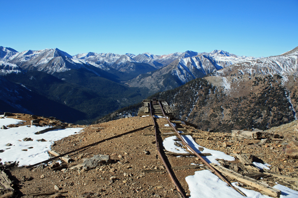
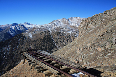 I'd pretty much broken tree line, but for a few here hardy souls here and there, and the trail climbed steeply upward, still on the old road which I knew would remain the case up to the next two mine ruins. The road had rock from small slides on it here and there but was never unclear. The route traversed the slope of the mountain and then into a broad gully that revealed more mine ruins higher up the drainage. Back and forth a few more times and then I landed on the old pad where mine rails led from a collapsed adit to the dump point overlooking the valley. Some folks think the mine ruins are an abomination, but me . . . I'm a mining engineer and I get a kick out of the old ruins if for no reason other than their testament to ingenuity and determination of miners past.
 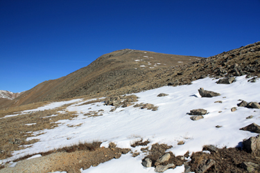 I trekked past the lower dump point and then on up and around a hairpin to the upper dump, before cutting off the end of the road to climb the slopes in the direction that I knew would lead to the summit. The footing was loose here and there but I kept the traverse gentle until I broke the skyline and could see the apparent summit not that far away, perhaps another 400 feet of vertical over a half mile . . . I took the tamest grass route offered and crossed a flat before climbing the gentle slope to the summit, actually to the top of the "summit" rise that then gave way to the summit proper, perhaps another 5 minutes and 75 more vertical feet. Soon enough I was on the summit of this rather tall hill, taking in the expanse of the upper Sawatch, which for the end of October was pretty sparse in the snow department.
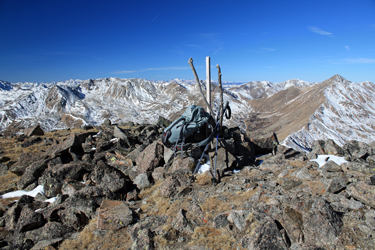 The day was truly bluebird, so I took 15 minutes on the summit to eat a bit and take some photos. I'd planned this mid week climb around a forecast that said the winds that commanded the weekend would die off and die off they did . . . I sat in still air, taking in the sun. I'd started at 8 and was on the summit at 11:30, having taken breaks here and there to shoot photos along the way. I was back at the truck at a bit after 1:40 . . . quite content to having made the drive after all.