-
Mt. Bierstadt Group Summit - Front Range, Colorado
-
A rest before the summit push on Dallas Peak - San Juan Range, Colorado
-
Broken Ankle + 6 Miles = Tired
-
The classic San Juan approach - San Juan Range, Colorado
-
Overlooking Noname Basin from Twin Thumbs Pass - San Juan Range, Colorado
-
Upper Noname Basin - San Juan Range, Colorado
-
Nearing Noname Cabin - San Juan Range, Colorado
-
Twin Thumbs Twins - San Juan Range, Colorado
-
Nearing the summit of Pt. 13,736 - Sawatch Range, Colorado
-
Blustery day on Iowa Peak - Sawatch Range, Colorado
-
Morning snow at 15k, Cerro Ramada - Cordillera Ramada
-
Artesonraju from the summit of Nevado Pisco - Cordillera Blanca, Peru
-
February crowds on Gray's Peak - Front Range, Colorado
-
Kicking steps on Cerro Lliani - Cordillera Vilcanota, Peru
-
Final traverse to the summit of Wheeler Mountain - Ten Mile Range, Colorado
-
The long walk to Pachanta - Cordillera Vilcanota, Peru
- banner31
Afternoon at 17k on Cerro Ramada - Cordillera Ramada, Argentina
- banner22
The final ridge on Iowa Peak - Sawatch Range, Colorado
-
Summer summit on Longs Peak - Front Range, Colorado
-
A rest day at the Pachanta Hot Springs - Cordillera Vilcanota, Peru
-
Mind over matter on Mt. Parnassas - Front Range, Colorado
-
Rest stop on Cerro Lliani - Cordillera Vilcanota, Peru
- banner30
Post nap surprise on Cerro Ramada - Cordiller Ramada, Argentina
-
Summit on Cerro Lliani - Cordillera Vilcanota, Peru
- banner23
Ridge walking on Grizzly Peak - Sawatch Range, Colorado
-
Enroute the summit via the West Ridge on Pacific Peak - Ten Mile Range, Colorado
-
Mule train bound for Chilca - Cordillera Vilcanota, Peru
-
Taking in the view from Fletcher Peak - Ten Mile Range, Colorado
-
Hiking on Silverheels - Mosquito Range, Colorado
-
Traversing! Gladstone Peak - San Juan Range, Colorado
- banner24
The best of times at Willow Lake - Sangre de Christo Range, Colorado
- banner29
High Altitude Cerebral Edema? - Cordillera Ramada, Argentina
-
Bound for Chilca - Vilcanota Range, Peru
-
Going alpine light, Holy Cross Ridge - Sawatch Range, Colorado
-
Cumbre! Campa I - Cordillera Vilcanota, Peru
-
Roadside lunch with the best of company - Cordillera Vilcanota, Peru
- banner25
Long ridge walk to the summit of California Peak - Sangre de Christo Range, Colorado
- banner28
Crossing el Rio Colorado . . . in the afternoon - Cordillera Ramada, Argentina
- banner37
Dealing with Fall snows high on Casco Peak - Sawatch Range, Colorado
-
Moonrise over Mercedario - Cordillera Ramada, Argentina
-
Still climbing at 20,900 on Cerro Ramada - Cordiller Ramada, Argentina
-
Talus on Halo Ridge, Mt. of the Holy Cross - Sawatch Range, Colorado
- banner26
Deteriorating conditions on Mt. Arkansas - Ten Mile Range, Colorado
- banner27
After the climb - Cordillera Ramada, Argentina
- banner38
Taking in the view from the summit of Crystal Peak - Tenmile Range, Colorado
-
Topping out on Mt. Arkansas' North Couloir - Mosquito Range, Colorado
-
Glissade on Mt. Arkansas - Mosquito Range, Colorado
-
Hard snow morning on Teakettle Mountain - San Juan Range, Colorado
-
Spring snow announces the start of the climb on Dallas Peak - San Juan Range, Colorado
-
Crossing the Eolus Catwalk - San Juan Range, Colorado

 The fog that rose from the valley the previous evening was gone by morning . . . as were Alcides' mules. Alcides does not hobble the stock or make any effort to ensure that they are near the camp in the morning. One of the horses seemed to be a loner while the other two tended to hang together, but none of the three had any compulsion to report to the tent at first light to get pounds of gear loaded on it and make some trek over yet another 15,000 foot pass.
 The route from the Piedras Grandes camp leaves the mining road and heads up the hill via a series of switchbacks to gain the floor of a higher valley leading toward the Sunchuli pass. The route passes a waterfall and then "flattens" to a gentle grade for a few miles up the floor of the valley. By the time you reach the mid point of the day's four hour trek, you look back over your shoulder to see the Cololo and its sister peaks or walk on and take in the Cuchillo peaks as they get closer and closer.
 The Cuchillo peaks rise to your left and right as you near the start of the climb to the Sunchuli pass, but before you climb to the pass, you have to cross a wide swath of mossy hummocks interwoven with streams of icy glacial melt water. There did not seem to be a given path, which most likely meant that we had missed the obvious course and now had to risk wet feet until we regained the true path. We passed the glacial lake that lies below Cuchillo II and looked at the steep path to the pass proper.
 Alcides was goading the mules to make the climb and they were stopping to rest at each turn of the trail through its switch backed course. The climb is not that high with regard to vertical feet but the footing is loose and the course is steep. It is a tough enough path that G and I made darn sure we were not below any of the horses as they made the climb. They broke the crest of the trail and took the final one hundred yards to the pass on the single lane mining road that rejoined our path. We also gained the road and walked the final feet to the highest summit of the trek.
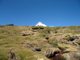 Saying that the last steep section of the pass did not have that many vertical feet of climb really does not tell the whole story. The sign at the top of the pass, noting the elevation was in excess of 16,500 feet tells the true story and also explained why we took the opportunity to stop a few times on the way, just as the stock had done. Sunchuli pass is at the low point of the saddle connecting Cuchillo I to the west and Cuchillo II to the east. Cuchillo II looked to have a number of impressive routes on it and we thought this peak might be our objective the next day but that decision would have to wait for us to arrive at camp and see what the overall prospects were.
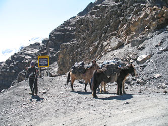 The Sunchuli camp is visible from the pass and located on a flat spot near a local herder's cabin. THe camp site has a stone corral, plentiful water and a latrine of sorts, meaning that it is halfway to being a ruin. We would be the only group in camp and it took us about 1/2 hour to descend to the camp proper. Mario and Alcides had unloaded the horses and the gear was piled for everyone to sort through for tents and camping gear. We got the individual tents up, the cook tent up and then set about deciding what we would climb the next day.
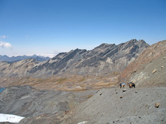 Our choices were may, we could climb Cuchillo I via the descent route shown in Yossi Brain's book or do a variation of the route that would require a half dozen pitches of steep snow on an exposed snow slope on the south side of the peak. The ascent route shown in the guide does not climb from the Sunchuli camp side of the pass so that option was not given serious thought as we would have had to re-cross the pass to get to the start point. Cuchillo II was an option but to make that climb we would also have to climb most of the way to the pass in order to gain a snow slope. Cuchillo II looked like a great climb but we still had other choices . . .
 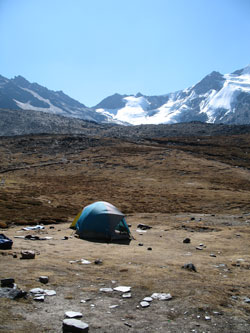 Our next set of options became visible when we climbed the slope behind the camp and looked up the valley toward to divide forming the spine of the southern Apolobamba. The Cuchillo peaks form more of an east west spur but the valley to the west contained a large glacier that, if crossed, would give access to the spine of the range and the most attractive target for us was a white snow covered hump that stood proud on the ridge. We talked about the options and chose the white hump. We did not know the name of the peak, its altitude, or if there was a good route across the glacier but that hump would be our target the next day.