-
Mt. Bierstadt Group Summit - Front Range, Colorado
-
A rest before the summit push on Dallas Peak - San Juan Range, Colorado
-
Broken Ankle + 6 Miles = Tired
-
The classic San Juan approach - San Juan Range, Colorado
-
Overlooking Noname Basin from Twin Thumbs Pass - San Juan Range, Colorado
-
Upper Noname Basin - San Juan Range, Colorado
-
Nearing Noname Cabin - San Juan Range, Colorado
-
Twin Thumbs Twins - San Juan Range, Colorado
-
Nearing the summit of Pt. 13,736 - Sawatch Range, Colorado
-
Blustery day on Iowa Peak - Sawatch Range, Colorado
-
Morning snow at 15k, Cerro Ramada - Cordillera Ramada
-
Artesonraju from the summit of Nevado Pisco - Cordillera Blanca, Peru
-
February crowds on Gray's Peak - Front Range, Colorado
-
Kicking steps on Cerro Lliani - Cordillera Vilcanota, Peru
-
Final traverse to the summit of Wheeler Mountain - Ten Mile Range, Colorado
-
The long walk to Pachanta - Cordillera Vilcanota, Peru
- banner31
Afternoon at 17k on Cerro Ramada - Cordillera Ramada, Argentina
- banner22
The final ridge on Iowa Peak - Sawatch Range, Colorado
-
Summer summit on Longs Peak - Front Range, Colorado
-
A rest day at the Pachanta Hot Springs - Cordillera Vilcanota, Peru
-
Mind over matter on Mt. Parnassas - Front Range, Colorado
-
Rest stop on Cerro Lliani - Cordillera Vilcanota, Peru
- banner30
Post nap surprise on Cerro Ramada - Cordiller Ramada, Argentina
-
Summit on Cerro Lliani - Cordillera Vilcanota, Peru
- banner23
Ridge walking on Grizzly Peak - Sawatch Range, Colorado
-
Enroute the summit via the West Ridge on Pacific Peak - Ten Mile Range, Colorado
-
Mule train bound for Chilca - Cordillera Vilcanota, Peru
-
Taking in the view from Fletcher Peak - Ten Mile Range, Colorado
-
Hiking on Silverheels - Mosquito Range, Colorado
-
Traversing! Gladstone Peak - San Juan Range, Colorado
- banner24
The best of times at Willow Lake - Sangre de Christo Range, Colorado
- banner29
High Altitude Cerebral Edema? - Cordillera Ramada, Argentina
-
Bound for Chilca - Vilcanota Range, Peru
-
Going alpine light, Holy Cross Ridge - Sawatch Range, Colorado
-
Cumbre! Campa I - Cordillera Vilcanota, Peru
-
Roadside lunch with the best of company - Cordillera Vilcanota, Peru
- banner25
Long ridge walk to the summit of California Peak - Sangre de Christo Range, Colorado
- banner28
Crossing el Rio Colorado . . . in the afternoon - Cordillera Ramada, Argentina
- banner37
Dealing with Fall snows high on Casco Peak - Sawatch Range, Colorado
-
Moonrise over Mercedario - Cordillera Ramada, Argentina
-
Still climbing at 20,900 on Cerro Ramada - Cordiller Ramada, Argentina
-
Talus on Halo Ridge, Mt. of the Holy Cross - Sawatch Range, Colorado
- banner26
Deteriorating conditions on Mt. Arkansas - Ten Mile Range, Colorado
- banner27
After the climb - Cordillera Ramada, Argentina
- banner38
Taking in the view from the summit of Crystal Peak - Tenmile Range, Colorado
-
Topping out on Mt. Arkansas' North Couloir - Mosquito Range, Colorado
-
Glissade on Mt. Arkansas - Mosquito Range, Colorado
-
Hard snow morning on Teakettle Mountain - San Juan Range, Colorado
-
Spring snow announces the start of the climb on Dallas Peak - San Juan Range, Colorado
-
Crossing the Eolus Catwalk - San Juan Range, Colorado

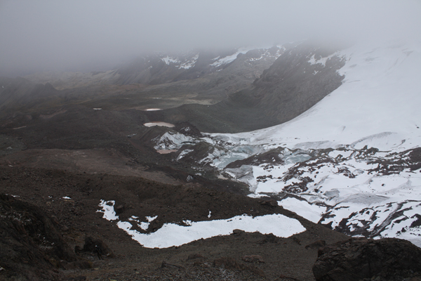
 The day was very different from the day we climbed Campa, we had heavy cloud cover very much like we had been experiencing in the afternoons when the clouds seemed to build around the surrounding peaks until the cold of night pushes them back so that the stars can brighten the night sky. However, the clouds cover did make for a warm and still morning approach.
 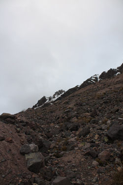 full daylight by the time we had to start thinking about starting to cut upward to the start point of the climb up the flank of Mariposa. The course of prior climbers was obvious at this point but that did not make the route any easier. Prior travels had not cut a permanent track in the fine material that formed the very compact side of the moraine. We traversed this "dirt" slope with care as we tried to climb without a slide back to a point below our starting point.
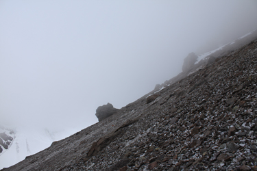 The scar we thought we saw from a distance was likely the combination of natural scree movement and foot traffic. We joined the route and slowly ascended the flank, aiming to gain the snowfield that we planned to crampon up to the ridge of Mariposa. However, the weather had other plans and it seemed, as we crossed the 17,000 foot mark, that we left the sedate valley below and climbed into a cold, windy, and cloud veiled layer that would obscure the route ahead and the route below. The wind, now gusting above 30 mph, bit into us and snow began to swirl about. We climbed on, hugging the edge of the rib that formed the side of this wide couloir, slogging our way up through the constantly sliding
 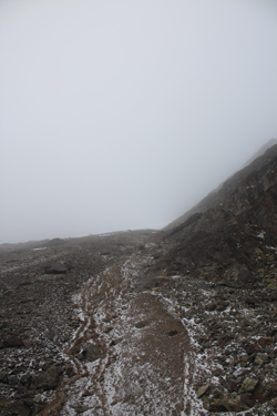 scree. The only path that promised any progress was this rib/couloir interface and its rock step after rock step nature didn't offer all that much promise when combined with the deteriorating weather.
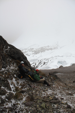 Mariposa ridge would be a long, very long, slog. We also had to take into account the stomach and bowel issues that most of us were fighting at this point . . . we stopped, talked and turned the climb. The gig was up for Mariposa and more likely than not, the "big" mountain portion of this trip was concluding as well. But that was OK, we long ago learned that a two week trip to the Andes that includes a good trek and an 18k+ summit is a total success. Every other summit is just icing on the cake.
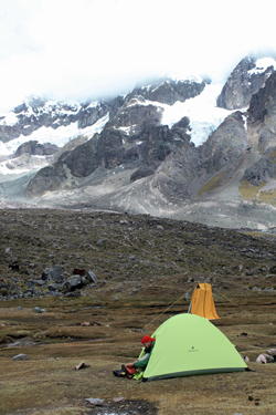 We descended the scree scar and on back down the steep side of the moraine to the base of its trough. Rather than drop down valley, we elected to retreat via the route that Bob and I hiked through the day before, a traverse of the upper portion of the moraine with a stop at the lake at the toe of the Campa Glacier. From there we descended the moraine to camp, arriving at about 11 in the morning. The clouds came and went throughout the day but it was clear that the upper reaches of the Ausangate Massif was having an off weather day and that our call as to the conditions up high we certainly accurate. We lounged about for the rest of the day and planned our next move, a relocation of our camp to a spot just above the small settlement of Jampa in the valley located on the other side of Campa in the adjoining valley.