Crystal Peak
June 13, 2009 - Southwest Ridge (spring snow)
 I'd been up all of the Mayflower Gulch peaks with the exception of Crystal and but for a tedious Friday that held me in the office until 6 p.m., precluding a run for the Sangre de Christo's after work I did not intend to climb Crystal. Instead, I was homeward bound and determined to salvage a Saturday climb using the alpine start mechanism. I've concluded that there are two alpine starts, the easy one where you leave the tent as 4 in the a.m. and the hard one where I leave Cheyenne to get to the trail head at 4 or 5 in the a.m. This Saturday climb was, by virtue of a dismal Friday, destined to be of the second variety. I'd been up all of the Mayflower Gulch peaks with the exception of Crystal and but for a tedious Friday that held me in the office until 6 p.m., precluding a run for the Sangre de Christo's after work I did not intend to climb Crystal. Instead, I was homeward bound and determined to salvage a Saturday climb using the alpine start mechanism. I've concluded that there are two alpine starts, the easy one where you leave the tent as 4 in the a.m. and the hard one where I leave Cheyenne to get to the trail head at 4 or 5 in the a.m. This Saturday climb was, by virtue of a dismal Friday, destined to be of the second variety.
Regardless, I was enthused enough to roll out of bed at 3 a.m. and hit the road. I drove past the standard first hour (I-25 at Exit 240) and second hour (Idaho Springs High School football field) checkpoints en route to Leadville, knowing the trip would take just a few minutes less than three hours. That may seem like a high price to pay if you live in Denver, but what if you lived in Baltimore for 14 years after coming to love the high country during your college years . . . You get the idea, an extra hour and twenty minutes sure beats waiting to accrue enough vacation and the need to buy a plane ticket. I don't blink an eye at the run from Wyoming . . . Given that, the peaks in Mayflower Gulch are pretty, hold their snow well, and I generally have them to myself, at least during the spring. Crystal Peak it would be.
 I gave thought to approaching Crystal from the Quandary side but I'd read a recent trip report that noted an old mining road that skirted around the base of Mayflower Hill, cutting off the crossing of Mayflower Creek, the willows surrounding the creek, and what I've come to feel is a miserable little climb up the cleft that delivers Pacific Creek to Mayflower Gulch. Its not a difficult climb, and in this season it is not even a terrain trap, but I just did not want to do it again. Though I'm grousing about a lousy 150 feet of vertical, in reality the old road approach intrigued me. I gave thought to approaching Crystal from the Quandary side but I'd read a recent trip report that noted an old mining road that skirted around the base of Mayflower Hill, cutting off the crossing of Mayflower Creek, the willows surrounding the creek, and what I've come to feel is a miserable little climb up the cleft that delivers Pacific Creek to Mayflower Gulch. Its not a difficult climb, and in this season it is not even a terrain trap, but I just did not want to do it again. Though I'm grousing about a lousy 150 feet of vertical, in reality the old road approach intrigued me.
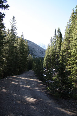
 I got to the trail head at 6:00 and changed into the climbing duds, noting no other vehicles in the parking area. Looked like I would at least start off as a solo act and I figured I would not cross paths with anyone but possibly for climbers approaching Crystal from the other side. I locked up the truck and walked the 4WD road only long enough to get to the cut off for the stream control structure. I crossed the creek on the structure and climbed the bank to the old diversion ditch access road that the map and another climber reported to circle the base of Mayflower Hill. This is a nice route, paralleling a ditch cut into the hill to bring water from the creek on the opposite side of Mayflower Hill around to the Mayflower Gulch drainage. I trekked along this really pleasant path, listening to a book on tape that I had downloaded into a new iPod during the week. I got to the trail head at 6:00 and changed into the climbing duds, noting no other vehicles in the parking area. Looked like I would at least start off as a solo act and I figured I would not cross paths with anyone but possibly for climbers approaching Crystal from the other side. I locked up the truck and walked the 4WD road only long enough to get to the cut off for the stream control structure. I crossed the creek on the structure and climbed the bank to the old diversion ditch access road that the map and another climber reported to circle the base of Mayflower Hill. This is a nice route, paralleling a ditch cut into the hill to bring water from the creek on the opposite side of Mayflower Hill around to the Mayflower Gulch drainage. I trekked along this really pleasant path, listening to a book on tape that I had downloaded into a new iPod during the week.
I'm generally not a solo climber as I really like company on a climb . . . its a part of the experience that I look forward to. But after a Cheyenne winter, and practicing law for living (if you don't do it, don't start), I'm usually up for a two day solo climbing weekend to work out the mental kinks. However, my greatest impediment to getting out and climbing solo, here and there, is the dread of abject boredom in the early morning. I'm a talker and if I'm solo, I'm very quickly on the verge of going stir crazy, so I figured I'd give an iPod a try. Even though I'm sometimes on the cusp of being a Luddite, won't use an ATM card, and insist on manual locking hubs, I like this iPod gig.
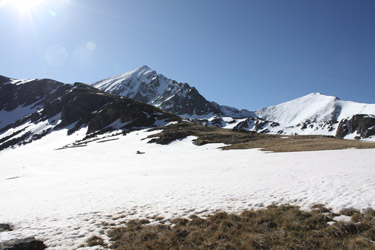
 I traversed the base of the hill and arrived at the terminus of the road, another flow control structure. The map said I would not have too much timber to get through before I was on open ground and that is exactly the case. Some sparse woods and then you are out in the open, willows of course, but I still count that as open. The neat thing is that there are enough gaps in the willows that you never bash a course. Zig left, zig right but there is a path through and soon enough I had arrived at the steeper ground that marks the ascent to the valley that lies at the base of Pacific, Atlantic, and Crystal peaks. The climb is not steep and after the first hump, I crossed a flat snowfield before taking on a second and slightly more steep section that brought me to the same elevation as the base of the West Ridge on Pacific, albeit separated from that route by a shallow snow filled cleft. I traversed the base of the hill and arrived at the terminus of the road, another flow control structure. The map said I would not have too much timber to get through before I was on open ground and that is exactly the case. Some sparse woods and then you are out in the open, willows of course, but I still count that as open. The neat thing is that there are enough gaps in the willows that you never bash a course. Zig left, zig right but there is a path through and soon enough I had arrived at the steeper ground that marks the ascent to the valley that lies at the base of Pacific, Atlantic, and Crystal peaks. The climb is not steep and after the first hump, I crossed a flat snowfield before taking on a second and slightly more steep section that brought me to the same elevation as the base of the West Ridge on Pacific, albeit separated from that route by a shallow snow filled cleft.
 I now had Crystal firmly in my sights and the course was going to be snowy, no way around that as the spring mantle of snow was very much there. I stepped onto the snow and my foot went in to my knee but that is OK, I was near the edge and I always expect crud at the edge of any snowfield. Alternatively, perhaps the snow was in lousy shape all the way to the climb up to the Crystal- Pacific ridge and I was about to decide whether to fight the posthole battle or turn the climb and curse my selection of routes. My solution was to go for the center of the snowfield, at the price of a curving approach to the climb to the ridge, figuring the center was where the snow would be coldest and able to support my weight. I was right and soon enough, I had a good trudge going with just a post hole here and there, but not enough to cramp my style. I now had Crystal firmly in my sights and the course was going to be snowy, no way around that as the spring mantle of snow was very much there. I stepped onto the snow and my foot went in to my knee but that is OK, I was near the edge and I always expect crud at the edge of any snowfield. Alternatively, perhaps the snow was in lousy shape all the way to the climb up to the Crystal- Pacific ridge and I was about to decide whether to fight the posthole battle or turn the climb and curse my selection of routes. My solution was to go for the center of the snowfield, at the price of a curving approach to the climb to the ridge, figuring the center was where the snow would be coldest and able to support my weight. I was right and soon enough, I had a good trudge going with just a post hole here and there, but not enough to cramp my style.
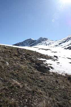
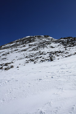
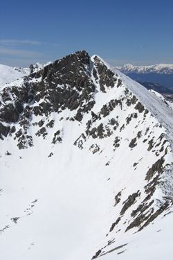
I traversed in a sweeping curve to the base of the climb up to the saddle and transitioned into a good rest step and occasional zig left or right when the french footing that I like so much got a bit tiresome. The climb to the ridge might be 500 feet of vertical and on good snow, the time passed quickly and soon enough I was on the saddle proper, looking not at the route up Crystal but instead at the snow climb offered by that fabulous looking North Couloir of Pacific Peak. But that would have to wait for another day . . . I turned and stepped my way on up Crystal's Southwest Ridge, picking my way through the talus and generally following the track of an earlier climber, likely from just a day or two before.
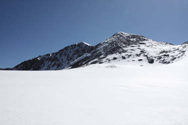
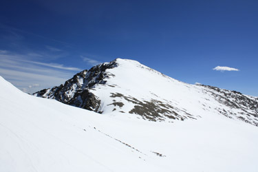 The Southwest Ridge route leads first to a false summit before dropping slightly and then climbing to the summit proper. I chose not to go over the false summit but instead to gain the approximate elevation of the sub saddle and then traverse around to hit the start of the climb to the summit proper with a minimum of lost elevation. I crossed the wide saddle and made the climb to the summit proper. The route was all snow with steep rolls here and there that did not quite call for the use of an axe, due to the softening surface . . . but had it been hard frozen I'd have broken out the axe due to the gentle but none the less many hundred foot run out to the valley far below. The Southwest Ridge route leads first to a false summit before dropping slightly and then climbing to the summit proper. I chose not to go over the false summit but instead to gain the approximate elevation of the sub saddle and then traverse around to hit the start of the climb to the summit proper with a minimum of lost elevation. I crossed the wide saddle and made the climb to the summit proper. The route was all snow with steep rolls here and there that did not quite call for the use of an axe, due to the softening surface . . . but had it been hard frozen I'd have broken out the axe due to the gentle but none the less many hundred foot run out to the valley far below.
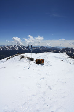
 I arrived on the summit, solo and without other climbers in sight. The usual photos were taken but after no more than five minutes, I was headed on back down, figuring that the snow was getting softer with every passing minute of bluebird sunshine. And was I right . . . I dropped into the knee a few times during the traverse back around the false summit onto the talus to drop to the intermountain saddle. The descent to the valley floor was still in good shape as was the first few hundred yards of the sweeping course I used for my approach. But them I crossed some unseen "posthole contour" and the fun started in earnest. I arrived on the summit, solo and without other climbers in sight. The usual photos were taken but after no more than five minutes, I was headed on back down, figuring that the snow was getting softer with every passing minute of bluebird sunshine. And was I right . . . I dropped into the knee a few times during the traverse back around the false summit onto the talus to drop to the intermountain saddle. The descent to the valley floor was still in good shape as was the first few hundred yards of the sweeping course I used for my approach. But them I crossed some unseen "posthole contour" and the fun started in earnest.
 I slogged my way through what was now spring mush, up to the knees and half way to the thighs in other spots. I slowed my pace and shifted to pre-compacting the snow with a light "pre-step" before putting my weight on the advancing foot but even that did not do the trick in a few spots where the snow had rotted out to a pile of slushy facets. I knew however that this was my last "gotta cross" snowfield and that once across, I would be able to connect the dots until I dropped down into the willow maze, putting the snow behind me. That came soon enough as I scored a few solid sections and then was off the snow, postholes behind me. Descending, as compared to ascending, through the willows made route finding a non issue and I was soon enough back at the flow control structure and back on the road for the hike back to the truck. I slogged my way through what was now spring mush, up to the knees and half way to the thighs in other spots. I slowed my pace and shifted to pre-compacting the snow with a light "pre-step" before putting my weight on the advancing foot but even that did not do the trick in a few spots where the snow had rotted out to a pile of slushy facets. I knew however that this was my last "gotta cross" snowfield and that once across, I would be able to connect the dots until I dropped down into the willow maze, putting the snow behind me. That came soon enough as I scored a few solid sections and then was off the snow, postholes behind me. Descending, as compared to ascending, through the willows made route finding a non issue and I was soon enough back at the flow control structure and back on the road for the hike back to the truck.
The climb up Crystal was a bit slower than I'd expected, I'd left the car at 6:30 and summitted four hours later and made it back to the truck just a few minutes before one in the afternoon. But it was a good climb and made just that much better by a variation in the approach that introduced a new approach into the Mayflower Gulch climbing profile.
Adjacent Pacific peak in the summer and winter . . .
|
