Kat Carson (Columbia Point)
June 26-27, 2010 - Outward Bound Couloir
July 6, 2010 - Approach via Willow Creek Trail . . .
G was down to four 14'ers and the trip into the Weminuche on the train to knock out the last three was planned for August. That left only Kit Carson in the Sangres so it looked like the last few month's talk of the Outward Bound Couloir would come to fruition. But this was not the usual two or three person trip, no for the first time ever we were up to five, an unheard of number in our group. G mentioned the trip to two co-workers and they were in without hesitation and I too mentioned the trip to a climbing associate and he also bit on the idea of a final snow climb of the season. WE were off to the Sangres.
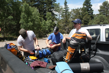 The Cheyenne contingent met at my house at 6 a.m. for the trip to the Sangres. Calvin and Jeff were on board for the first time, neither having ever set foot on a 14'er and one setting a new personal altitude record with every step above 11k. We met up with John BB at the Morrison park and ride and we were all off toward Crestone and the Willow Lake trail head. Sonic in Salida provided mediocre sustenance en route and gave our blood the necessary nutrients to feed the swarm of mosquitoes that met us at the trail head parking area. I'm not talking a few bugs but swarms of the little bastards, more than I've ever seen in 12 years of hiking in Colorado. The bug juice went on and that afternoon we all hoped that, with every The Cheyenne contingent met at my house at 6 a.m. for the trip to the Sangres. Calvin and Jeff were on board for the first time, neither having ever set foot on a 14'er and one setting a new personal altitude record with every step above 11k. We met up with John BB at the Morrison park and ride and we were all off toward Crestone and the Willow Lake trail head. Sonic in Salida provided mediocre sustenance en route and gave our blood the necessary nutrients to feed the swarm of mosquitoes that met us at the trail head parking area. I'm not talking a few bugs but swarms of the little bastards, more than I've ever seen in 12 years of hiking in Colorado. The bug juice went on and that afternoon we all hoped that, with every 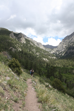 foot of upward travel, we would somehow reach a critical altitude that would offer relief from the torment. foot of upward travel, we would somehow reach a critical altitude that would offer relief from the torment.
I'd hiked to Willow Lake almost ten years earlier when I did Kit Carson and I remembered that Willow Lake was not that far but that it was a bit of a slog. The trip was off to a good start when I managed to fall off the log bridge over Willow Creek and half soak a foot and boot. I haven't come off a log in years, probably two decades and it took some degree of skill as I had hiking poles to maintain my balance. What a beginning for a climb whose aim point would be a steep snow slope with hundreds of feet of run out.
After the first creek crossing we walked the hundred or two yards before the trail turned east so we could 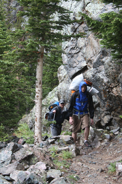 slog through a sandy stretch, just what I needed with a wet boot. We next took on what my count had as 12 switchbacks in order to cover what is probably the first mile of the trek and put us along a traverse on the hillside above a really pretty open meadow on the valley floor below. slog through a sandy stretch, just what I needed with a wet boot. We next took on what my count had as 12 switchbacks in order to cover what is probably the first mile of the trek and put us along a traverse on the hillside above a really pretty open meadow on the valley floor below.
From the meadow stretch the trail remains gentle for a bit before beginning a second series of switchbacks, I don't know how many but no less than 20 would be my best guess. On and on we climbed, though the turns really caught my attention on the way down as I hardly recalled them on the way up. Probably the reason I wasn't counting was that the thunderstorm that started as a drizzle ended as steady rain that consumed the second half of the upper switchbacks and set my mind to fixate on my increasingly wet outer layer and my later debate as to the ability of the body to dry the inner layer that I finally had the wisdom to cover with my soft shell. We swapped leads a number of times before individuals tired and we slowly split into two groups separated by a few minutes of trail time.
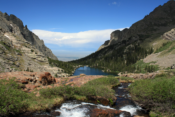
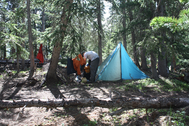 We re-joined at the stream crossing below the final headwall to climb onward as a fivesome to the second stream crossing and onward through the upper forest that was littered with blow down from a year or two before. John had heard of the downed timber but it was still surprising to see so many large trees down, all toppled and showing how shallow their root systems really were. And did I mention that the mosquitoes were present for the whole of the hike to this point, swarms of them? We finally arrived at the camp area before the lake and picked out a spot for the night. There was no let up as to bugs but that was OK as G and I had decided to spend the night in the BD Megamid that not only lacks a floor but whose sides would not reach to or touch We re-joined at the stream crossing below the final headwall to climb onward as a fivesome to the second stream crossing and onward through the upper forest that was littered with blow down from a year or two before. John had heard of the downed timber but it was still surprising to see so many large trees down, all toppled and showing how shallow their root systems really were. And did I mention that the mosquitoes were present for the whole of the hike to this point, swarms of them? We finally arrived at the camp area before the lake and picked out a spot for the night. There was no let up as to bugs but that was OK as G and I had decided to spend the night in the BD Megamid that not only lacks a floor but whose sides would not reach to or touch 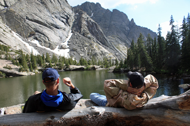 the ground to provide protection against the bugs. This was going to be a great night. the ground to provide protection against the bugs. This was going to be a great night.
We set up camp and after a brief wander over to the lake, we settled on a large rock outcrop next the camp and enjoyed our dinner. Rather than hauling the cook gear, we'd elected to do a cold bagel/cheese/summer sausage dinner. In the meantime, John brought a pocket rocket and pot, so he ate hot chow in lieu of our cold fare. Calvin brought chocolate along and Jeff brought 4 oz. of home made Kahlua. After dinner, we partook of an ounce of Baileys and by nine or so, we all drifted off to our respective tents to get some sleep before the alarm went off at 3:30 a.m.
June 27, 2010 - Challenger Point, Kit Carson, & Kat Carson
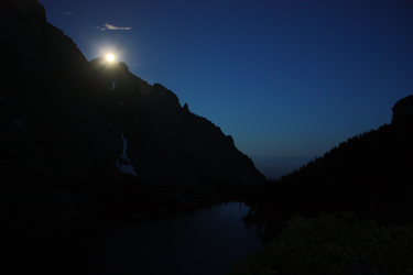 Everyone was up and ready to go with a minimum of fuss by about 4:15, having had breakfast of some sort and being quite joyful at the lack of bugs in the early morning hours. The night before we had decided to split the group into tow parties, one bound for Kat Carson via the OB couloir and the other bound for Kit Carson via Challenger Point. We would hope to meet up on our respective summits and then meet again at camp after the respective climbs. The reason for our split was that Calvin and Jeff were both virgin 14'er climbers and G wanted to make sure they were on route and had a little bit of coaching along the way as to the rest step, common hazards and the miscellany of climbing that one can absorb from having an old pro along for the climb. Everyone was up and ready to go with a minimum of fuss by about 4:15, having had breakfast of some sort and being quite joyful at the lack of bugs in the early morning hours. The night before we had decided to split the group into tow parties, one bound for Kat Carson via the OB couloir and the other bound for Kit Carson via Challenger Point. We would hope to meet up on our respective summits and then meet again at camp after the respective climbs. The reason for our split was that Calvin and Jeff were both virgin 14'er climbers and G wanted to make sure they were on route and had a little bit of coaching along the way as to the rest step, common hazards and the miscellany of climbing that one can absorb from having an old pro along for the climb.
 John and I took the lead out of camp and the others followed us, about a minute behind. We skirted the lake, hugging the shore until we were sure we had missed the trail up and around the headwall of the lake. From there it was simply a matter of doing a little vertical bushwhacking until we hit a trail cut sufficient to convince us that we were on the proper route. We scored the trail quite quickly and both groups were soon climbing to surmount the head wall forming the rear of Willow Lake and granting access to the valley from which we would start our respective routes. We stopped at the first stream crossing to take some pictures and then moved on across the second stream crossing to begin our climb up the base of the valley. John and I took the lead out of camp and the others followed us, about a minute behind. We skirted the lake, hugging the shore until we were sure we had missed the trail up and around the headwall of the lake. From there it was simply a matter of doing a little vertical bushwhacking until we hit a trail cut sufficient to convince us that we were on the proper route. We scored the trail quite quickly and both groups were soon climbing to surmount the head wall forming the rear of Willow Lake and granting access to the valley from which we would start our respective routes. We stopped at the first stream crossing to take some pictures and then moved on across the second stream crossing to begin our climb up the base of the valley.
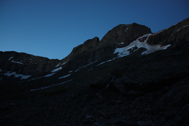
 By this point the sky had started to lighten and once we lost the trail proper, John and I traversed up valley along a gently climbing course. We pushed our way through a few tufts of willows, usually via a game trail that gave enough of a foot path to just about avoid a classic willow bashing effort. The night was kind and left the willows dew free so although we were often waist deep in willows we came through the experience on the dry side. Once beyond the willows we kept traversing up the side of the valley, gaining a bit of elevation all along the way and seeking to skirt below the fin that guards the entrance to the OB couloir. By this point the sky had started to lighten and once we lost the trail proper, John and I traversed up valley along a gently climbing course. We pushed our way through a few tufts of willows, usually via a game trail that gave enough of a foot path to just about avoid a classic willow bashing effort. The night was kind and left the willows dew free so although we were often waist deep in willows we came through the experience on the dry side. Once beyond the willows we kept traversing up the side of the valley, gaining a bit of elevation all along the way and seeking to skirt below the fin that guards the entrance to the OB couloir.
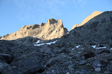
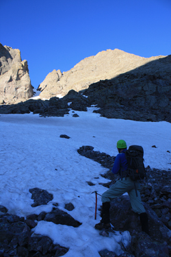 The only terrain of consequence was a band of rock fall that clearly came from the flank of Kit Carson and when I say rocks, I mean those big ones . . . about the size of a semi tractor. I picked out a hopping and jumping path through the boulders and talus until we had crossed the obstacle and spied a streak of white. I hoped the streak was a snow finger that would be continuous enough to get us to the base of the couloir where I hoped we would have good snow up through the climb proper. We continued to the start of the snow and I was almost correct in that there was enough snow that once we put the crampons on, we crossed but 100 feet of rock and then higher up, another 75 foot rock band. The only terrain of consequence was a band of rock fall that clearly came from the flank of Kit Carson and when I say rocks, I mean those big ones . . . about the size of a semi tractor. I picked out a hopping and jumping path through the boulders and talus until we had crossed the obstacle and spied a streak of white. I hoped the streak was a snow finger that would be continuous enough to get us to the base of the couloir where I hoped we would have good snow up through the climb proper. We continued to the start of the snow and I was almost correct in that there was enough snow that once we put the crampons on, we crossed but 100 feet of rock and then higher up, another 75 foot rock band.
 We stopped at the base of the first snow field to don the crampons and helmets and to break out the ice axes for the proper part of the climb. I expected good snow conditions as we had crossed a snow patch earlier and lower down that was hard summer neve that I knew would take only the points of our crampons. A good sign for snow higher up? We stepped onto the first snow and it was neve, good enough that getting a fast self arrest would be key if the feet went the wrong higher up on the slope. John led off and within ten minutes or so we'd topped the first snow field and crossed a patch of rock to start up the second patch of snow. The angle was pretty flat at first but eventually increased to perhaps 30 degrees. We stopped at the base of the first snow field to don the crampons and helmets and to break out the ice axes for the proper part of the climb. I expected good snow conditions as we had crossed a snow patch earlier and lower down that was hard summer neve that I knew would take only the points of our crampons. A good sign for snow higher up? We stepped onto the first snow and it was neve, good enough that getting a fast self arrest would be key if the feet went the wrong higher up on the slope. John led off and within ten minutes or so we'd topped the first snow field and crossed a patch of rock to start up the second patch of snow. The angle was pretty flat at first but eventually increased to perhaps 30 degrees.
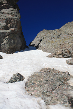
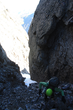
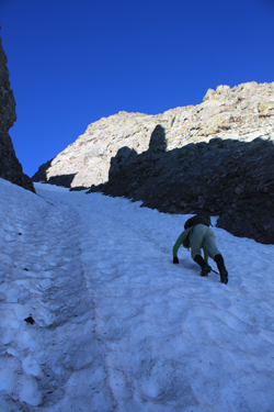 We had to cross a short stretch of rock to get to the base of the more shaded couloir proper and then the real climbing began. The sun lit portion was a bit softer on top but as the walls closed in, the snow hardened nicely and the angle steepened to about 40 degrees. There were some steps from prior climbers but they had obviously climbed in the early hours as their steps were little more than toe holes. We improved the track a bit and took advantage of the old steps when they suited our stride, perhaps about half of the climb. We had to cross a short stretch of rock to get to the base of the more shaded couloir proper and then the real climbing began. The sun lit portion was a bit softer on top but as the walls closed in, the snow hardened nicely and the angle steepened to about 40 degrees. There were some steps from prior climbers but they had obviously climbed in the early hours as their steps were little more than toe holes. We improved the track a bit and took advantage of the old steps when they suited our stride, perhaps about half of the climb. 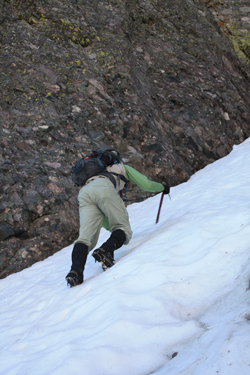 The guidebooks note that the top of the OB splits and that the route to Kat Carson takes the left spur, which was our choice. Now the real snow climbing began as the narrow cleft was angled at perhaps 45, maybe 50, degrees and filled with very hard neve. The guidebooks note that the top of the OB splits and that the route to Kat Carson takes the left spur, which was our choice. Now the real snow climbing began as the narrow cleft was angled at perhaps 45, maybe 50, degrees and filled with very hard neve.
John led off and front pointed a perfect path up the slope, leaving triple kicked snow holds that I will admit to taking full advantage of as I followed. Once atop the snow portion of the left slot, we climbed onto the upper slot that was fully melted out to loose rubble. We took off the crampons and other climbing gear and headed on up through the rubble filled canyon, where John accidentally dislodged a good 500 pound rock that seemed to have my name written on it. I promptly moved out of its way as it slid down to stop a just few feet from my prior course. Not a close call or near miss, but a slow motion reminder of the nature of the loose rock lining this portion of the route. Obviously, I'm not coming back to tackle this route after the close of the snow climbing season.
 We exited the couloir and looked to Kit Carson and spotted Gary and Calvin at the top of the Kit Carson Avenue ledge a quarter mile distant. We yelled in the still air and they waved back . . . we really were going to climb parallel paths to our respective summits. John and I worked our way up a ledge system for about 50 vertical feet before taking to the face proper and gaining another hundred feet to cross over to the other side of the ledge blocking our view of the Crestones and my fair share of sun in lieu of the shade we'd climbed in for the past hour or so. Now with the sun on my back, we gained the last hundred or so vertical feet to the summit of Kat Carson as evidenced by the brass marked honoring the Columbia shuttle crew. We exited the couloir and looked to Kit Carson and spotted Gary and Calvin at the top of the Kit Carson Avenue ledge a quarter mile distant. We yelled in the still air and they waved back . . . we really were going to climb parallel paths to our respective summits. John and I worked our way up a ledge system for about 50 vertical feet before taking to the face proper and gaining another hundred feet to cross over to the other side of the ledge blocking our view of the Crestones and my fair share of sun in lieu of the shade we'd climbed in for the past hour or so. Now with the sun on my back, we gained the last hundred or so vertical feet to the summit of Kat Carson as evidenced by the brass marked honoring the Columbia shuttle crew.
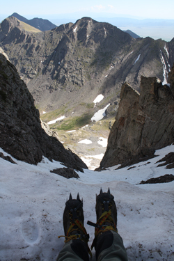
We looked to G and Calvin and saw that they were but five minutes from the summit of Kit Carson . . . we continued to watch as they made the high point, Calvin scoring his second 14'er of the day and G picking up number 51. We learned later that Jeff had hung back at Challenger Point and would await their return on the descent. We killed a few extra minutes on the summit to allow the warm air to perhaps 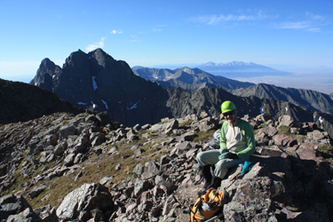 soften the snow in the couloir for our descent. After perhaps one half hour, we headed down, picking our way down our ascent route until we arrived at the top of the left branch. We had already decided the left branch was no the best descent route so we picked our way down another hundred feet or so and traversed toward the head of the other branch of the couloir. soften the snow in the couloir for our descent. After perhaps one half hour, we headed down, picking our way down our ascent route until we arrived at the top of the left branch. We had already decided the left branch was no the best descent route so we picked our way down another hundred feet or so and traversed toward the head of the other branch of the couloir.
Making it to the top of the other branch called for a number of class 4 down climbs, one of which presented a good 40 feet of exposure. However, the terrain was such that hand and foot holds were everywhere thanks to the Crestone Conglomerate. Soon enough we were sitting atop the right branch and putting the 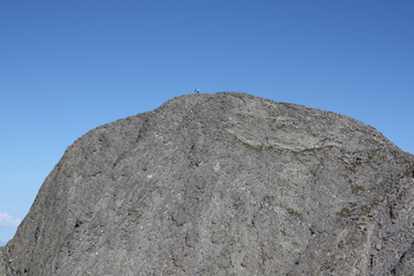 crampons on for the descent. The word of the day at this point was to take care as we would both be down climbing the first hundred feet facing in on front points. After that I was able to turn face out and descend the slope taking advantage of solid heel plant placements. We continued down through the couloir and eventually came to the sun hit portion of the climb. The snow was by then very soft and here and there we'd go in to the knee but mostly it was soft enough to provide good support and a good arrest if the feet failed to function. crampons on for the descent. The word of the day at this point was to take care as we would both be down climbing the first hundred feet facing in on front points. After that I was able to turn face out and descend the slope taking advantage of solid heel plant placements. We continued down through the couloir and eventually came to the sun hit portion of the climb. The snow was by then very soft and here and there we'd go in to the knee but mostly it was soft enough to provide good support and a good arrest if the feet failed to function.
 Once out of the couloir proper we easily stepped our way down the middle and lower snowfield to land at the edge of the small talus filling the upper lopes of the valley. The snow climbing gear went back into the packs and we hiked down to the base of the valley and pretty much followed the edge of the stream and/or bog down to the headwall above the lake. As we approached the lake, we picked up a trail of sorts and then had to stop to let mountain sheep traffic pass before we could cross the stream and descend back to camp. Sheep aside, we were soon around the head of the lake, dropping down and headed for camp. In the meantime, the bugs had returned and we were again swarmed by the mosquitoes that had plagued us the whole of the prior afternoon. Once out of the couloir proper we easily stepped our way down the middle and lower snowfield to land at the edge of the small talus filling the upper lopes of the valley. The snow climbing gear went back into the packs and we hiked down to the base of the valley and pretty much followed the edge of the stream and/or bog down to the headwall above the lake. As we approached the lake, we picked up a trail of sorts and then had to stop to let mountain sheep traffic pass before we could cross the stream and descend back to camp. Sheep aside, we were soon around the head of the lake, dropping down and headed for camp. In the meantime, the bugs had returned and we were again swarmed by the mosquitoes that had plagued us the whole of the prior afternoon.
John and I arrived in camp expecting to see G, Calvin and Jeff but they had not yet gotten back. We had looked for them on the ridge of Challenger Point but been unable to spot them, hence we figured they beat us back to camp. They had been on the ridge but we simply did not see them as we passed. They then stopped at the stream to hydrate and came into camp abut 45 minutes after our arrival. We had a bagel lunch, similar to dinner the night before, and then broke camp to head on back to the vehicles. The trek out was dry 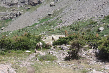 this time, though the thunder we heard and the virga in the valley kept us on notice that things could change without too much trouble on the part of Mother Nature. this time, though the thunder we heard and the virga in the valley kept us on notice that things could change without too much trouble on the part of Mother Nature.
I think were all amazed at the number of switchbacks on the descent but after a reduced period of eternity, we endured the last switchback, passed through the sand trough and rock hopped across the last stream to reach the trucks. From there it was easy, drive down to Crestone to change and then find some eats on the way home. Overall . . . not a bad trip . . . 14 to 15 miles of hiking and climbing over a 24 hour period . . . for five climbers, each of whom got a summit without serious weather.
|
