|
||||||||||||
|---|---|---|---|---|---|---|---|---|---|---|---|---|
Mount SheridanOctober 27, 2002 - via Leavick & Four Mile Creek
I had not been out in the mountains for a month therefore the conclusion of a series of mid terms seemed an appropriate signal for a cold weather climb. If I could avoid the cold, that would be well enough but the forecast was not encouraging when I left Cheyenne to take a shot at Mount Sheridan. Given that the weather might be bad and bad weather would likely translate into poor visibility, I chose a peak that I had at least approached before, from both the east and the west, and provided a combination of old mine roads and discernable ridges for ease of route finding. The final choice factor was that the whole of the climb would be above tree line, lessening the opportunity to be mistaken for a four legged animal just begging for a high velocity round through its orange backpack. I left Cheyenne on Saturday afternoon about three and figured to camp at the Four mile Campground, just a few miles short of the Leavick trailhead.
The weather down the Front Range was fine until I got to Georgetown where the slight drizzle turned to snow flurries and continued to build. I got off at the Bakerville exit to “sniff the air” and for some reason, most likely a one-month climbing drought; I got back on I-70, westbound. The weather improved a bit until Breckenridge where the snow came on in earnest and by the time I crossed Hoosier Pass it was dark and the road was both covered and slick. I eased down the pass, through Alma and on to Fairplay, before cutting south on 285 just a bit to catch the dirt road to Leavick. The road was by now covered and when I arrived at the campground, it was closed for the season. Honestly, this was no surprise and I really was not looking for a formal camp spot, but instead the generally flat area in front of the closure gate. By now it is 8 o’clock, dark, and the snow is really falling with 2” on the ground. My enthusiasm for setting the tent up for a solo night out was decreasing exponentially.
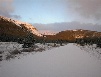
I got the first two poles up and then said “self . . . there is probably a warm room in Fairplay . . .” I let reason take over and found just the place ½ hour later. I thought myself a bit of the wimp for the decision but figured I would have more enthusiasm the next day should the weather be marginal than if I had spent the night in the tent. Sunday morning dawned cold and the doors of the truck were frozen enough to require a bit of tugging. I hit the road at 6 a.m. and made the Leavick trailhead by 7. The night’s snowfall was perhaps 2” at the most in the higher elevations but the road was still 2WD all the way to the gate. I parked and gathered my gear for the climb, not having seen either Sheridan or Sherman yet due to the heavy clouds hanging right about 13k. The temperature was not too bad (low 20’s with wind) and the sun was making an effort so there was promise of better weather. Regardless, I packed my extra layers, food, compass, map, and a handful of wands for good luck.
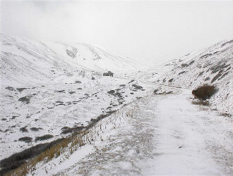
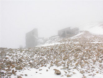
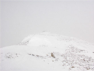
For those who may not have been to Sherman/Sheridan, the old mine road continues past the Dauntless Mine and winds ever upward to the ruins of the Hilltop Mine’s aerial tram station, just below the saddle connecting the two peaks. I had been up Sherman from this side before and just walked on the road toward the Hilltop. The fog came and went along with spates of wind, snow and ice pellets until the final switchback below the ruins. Then, I entered the cloud layer. The Hilltop simply disappeared into the fog, though I knew it was just ahead and did not come back into view until I reached the cabins just to the north of the tram station. The wind had also picked up and the saddle I was aiming for was gone from view. I knew where I was but stopped to give thought to the “go/no go” question that should arise whenever the visibility goes to hell. With map and compass accessible, I headed toward the base of the saddle, sticking to the rocky areas as I did not know how much of a snowfield and cornice had already formed above. I climbed about ½ way up and the cornice came into view, so I continued to climb, aiming to intersect the cornice where a rocky finger cut to the saddle proper. At this point, I also have a compass bearing shot and noted on the map to aid in the descent back to the Hilltop.
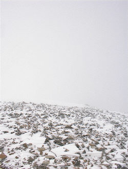
I left a wand at the point where I crossed the cornice to signal the drop point on the way back down and headed up the ridge line toward Sheridan. The visibility since the Hilltop had been hovering at perhaps 100 yards and seemed to be holding for the trip up the ridge. I connected some short sections of summer trail but stuck primarily to a snowfield that formed an almost continuous line up the east side of the ridge, placing an occasional wand and noting compass bearings in combination with altimeter readings in the event the visibility decreased markedly. The talus had not quite taken that winter freeze yet so here and there I stumbled but before too long I reached the summit ridge which leads past one big pile of rocks to a distant wind wall and monster cairn. A swig of water and shot of Goo later, I reversed course and headed back to the saddle below. The wind was blowing steadily and the clouds rose and fell but I had been meticulous in noting way points, bearings, and elevations on the assumption that my tracks would be gone within minutes of being made. And . . . they were gone in all but a few places.
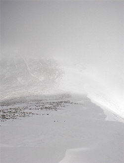
I arrived at my final wand, placed at the cornice, and took a moment to behold the arrival of a touch of blue sky, a glimpse of the upper flanks of Sherman and the wind that made that possible. I snapped some photos and headed down to the Hilltop, again choosing a rock route to cross the cornice and descend alongside the snow starting to pile up below the saddle. From the Hilltop ruins, it was down the old mine roads and again there was little sign of my tracks, made just 2 hours before. I stopped to poke around the Dauntless for a minute or two (got that mining fixation still) and then walked on back down the road to the truck for the ride home. The snow on the road around the truck was melting fast in the newly arrived sun and for the first time that day, I was able to see the summit of Sheridan above. Total round trip time was 4 hours, wind steady, but reasonable temperatures the whole way, i.e. beard freeze only on the windward side.
Adjacent Mount Sherman from the east, from the west, in the winter?
|
