Teakettle Mountain
May 6, 2012 - Black Gully from the base variation
The previous day we attempted Dallas Peak and were turned around by snow conditions just a short distance from the summit pitch. A defeat in hand, we broke camp and relocated to Ouray for a soak in the hot pool and attempt of Teakettle Mountain the next day. We figured that the spring snow had knocked us from our game once but that a subsequent try at another technical summit could not hurt. We took a look see at the road before setting up camp and saw that the gate was open, hence the next morning would have a much shorter approach that we had experienced on the same weekend one year before when we nearly summitted Sneffels after a very long walk in from the winter closure.
 The alarm was set for 3:45, a full 45 minutes after we had started on the trail the prior day. We knew would not have to walk nearly as far, figuring we would likely park at the lower 2WD trailhead and then be at the base of the climb after a mile or so of road march. We were in the truck by 4:15 and after a half hour happily arrived at not the 2WD trailhead but just 100 yards shy of the 4WD trailhead. By 5 a.m. we were geared up and after crunching about on a roadside drift, opted to leave the snowshoes in the truck, a three pound decrease in pack weight that we were both happy to accomplish. The alarm was set for 3:45, a full 45 minutes after we had started on the trail the prior day. We knew would not have to walk nearly as far, figuring we would likely park at the lower 2WD trailhead and then be at the base of the climb after a mile or so of road march. We were in the truck by 4:15 and after a half hour happily arrived at not the 2WD trailhead but just 100 yards shy of the 4WD trailhead. By 5 a.m. we were geared up and after crunching about on a roadside drift, opted to leave the snowshoes in the truck, a three pound decrease in pack weight that we were both happy to accomplish.
 The approach to the start of the climb was simple, walk a couple hundred yards and cut uphill and head for the shadow of Coffeepot. We climbed up through the last grouping of trees before tree line and the grass slopes above. In hindsight, we could have avoided a bit of inner tree snow had we gone another 50 yards before cutting upward, but it was still dark enough the I could not quite discern the end of the trees. We climbed slowly, still tired from the previous day but soon enough broke out of the trees and then trudged slowly up to the next topographic break, at about 11,800 ft, where there is a basin below the flank of the peak proper. We were still a bit west of where there is a basin below Teakettle and Coffeepot, so we The approach to the start of the climb was simple, walk a couple hundred yards and cut uphill and head for the shadow of Coffeepot. We climbed up through the last grouping of trees before tree line and the grass slopes above. In hindsight, we could have avoided a bit of inner tree snow had we gone another 50 yards before cutting upward, but it was still dark enough the I could not quite discern the end of the trees. We climbed slowly, still tired from the previous day but soon enough broke out of the trees and then trudged slowly up to the next topographic break, at about 11,800 ft, where there is a basin below the flank of the peak proper. We were still a bit west of where there is a basin below Teakettle and Coffeepot, so we 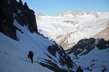 moved east, gaining just a bit of elevation as we were mainly seeking to skirt the southerly ridge of Coffeepot so that we could ascend its southeast flank as per the Roach guidebook. moved east, gaining just a bit of elevation as we were mainly seeking to skirt the southerly ridge of Coffeepot so that we could ascend its southeast flank as per the Roach guidebook.
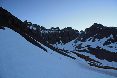
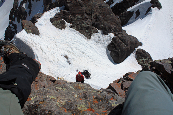
We now had sufficient light to gauge the terrain and rather than taking the standard route, we opted to put on the crampons and make an ascent up into the basin below the ridge connecting the two peaks, climbing directly to the Black Gully. We did not know where the Black Gully was at the time, we just saw that we could gain the ridge with an almost continuous snow line that did not look too steep. The crampons went on and we hiked up the first swell at the base of the basin and then most skirted talus to gain the base of the climb.
 By this point the flanks of Gilpin were brightly lit but the basin below Teakettle would remain dark for a while, which was good after our prior day's experience postholing through too warm snow, even high on Dallas Peak. The snowfield we selected was not quite continuous but as we got closer, we found that the northerly flank of the Coffeepot ridge was in shadow most of the time and would offer an almost continuous, albeit steeper snow line to the saddle between the two peaks. The snow was hard neve and after a bit, we swapped the hiking poles for ice axes as the runout grew more substantial and the snow got steeper. By this point the flanks of Gilpin were brightly lit but the basin below Teakettle would remain dark for a while, which was good after our prior day's experience postholing through too warm snow, even high on Dallas Peak. The snowfield we selected was not quite continuous but as we got closer, we found that the northerly flank of the Coffeepot ridge was in shadow most of the time and would offer an almost continuous, albeit steeper snow line to the saddle between the two peaks. The snow was hard neve and after a bit, we swapped the hiking poles for ice axes as the runout grew more substantial and the snow got steeper.
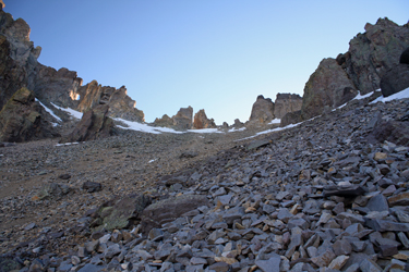
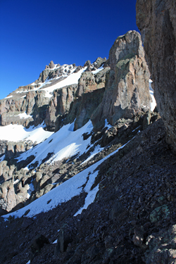 We attained the upper part of the couloir and shifted to the north to gain the snow that was filing a steep looking gully leading upward where the guidebook said we would gain Teakettle's higher terrain. We surmised correctly that this was the black gully and as the route description promised, it may have looked steep but was in fact more moderate terrain. We skirted the ridge on snow and then crossed a short fin to gain the couloir proper. From there we picked snow routes over scree and perhaps more We attained the upper part of the couloir and shifted to the north to gain the snow that was filing a steep looking gully leading upward where the guidebook said we would gain Teakettle's higher terrain. We surmised correctly that this was the black gully and as the route description promised, it may have looked steep but was in fact more moderate terrain. We skirted the ridge on snow and then crossed a short fin to gain the couloir proper. From there we picked snow routes over scree and perhaps more 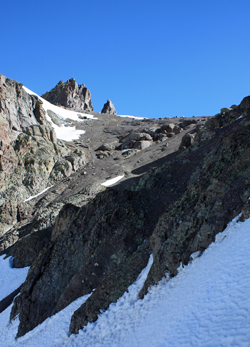 importantly over a section or two of alpine ice, which given the right conditions would make for a challenging little 30 foot ice pitch. Our course found good purchase to the left side as we were early and there was sufficient snow over the ice to allow us to crampon upward without worry. importantly over a section or two of alpine ice, which given the right conditions would make for a challenging little 30 foot ice pitch. Our course found good purchase to the left side as we were early and there was sufficient snow over the ice to allow us to crampon upward without worry.
The top of the climb yielded no view of the summit . . . only the white wall of a cornice that I climbed to see what the route looked like beyond. The description told of class 2 terrain from our position to the summit and sure enough, once I kicked a set of steps up 15 feet of 70 degree snow, there is was, a climber's trail along the base of a line of cliffs. We hiked the cliff base and soon came upon the promise of crossing a 45 degree snowfield that offered a cliff at its base as a reward to those without a ice axe arrest. I looked at Ed and suggested that neither of us slip. The slope appeared to lead to a break in the cliffs that was supposed 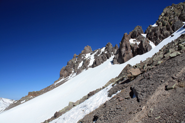 to be a sandy and not too steep gully that would lead through the cliffs and sure enough, we traversed the side slope and that was what we found. to be a sandy and not too steep gully that would lead through the cliffs and sure enough, we traversed the side slope and that was what we found.
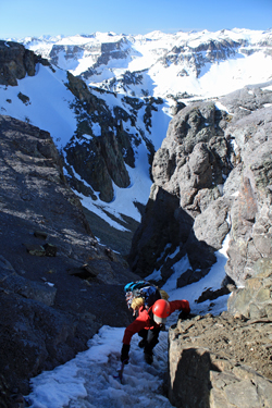
The sandy ground was a break from ice and snow or worse yet the talus tongues that we had crossed with crampons on as a matter of expedience. We were soon atop the cliffs and traversed one more moderate snow slope to arrive at a bit of steeper ground that guards the summit pinnacle. Soon enough we were at the base of the summit pitch and breaking out 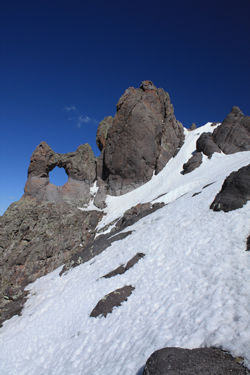 the rope and rack for the final effort. I'll admit to being not much of a rock climber, perhaps more out of inexperience than lack of ability. However, I took one look at the 25 feet or so of climbing and knew I'd play it safe on this one. the rope and rack for the final effort. I'll admit to being not much of a rock climber, perhaps more out of inexperience than lack of ability. However, I took one look at the 25 feet or so of climbing and knew I'd play it safe on this one.
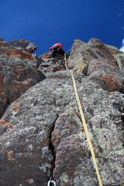 We placed sufficient pro at the base to anchor the belay and I set off to the summit. The first move to the alcove below the summit chimney was easy, but then the chimney really stymied me. I put a cam in a crack and took no less than 4 different breaks to study the ground after false starts. Then, on the last start, I stemmed in rather poor form, found the foothold I needed and climbed to another standing spot about ten feet above my last position. I placed a piece of pro and then moved to the summit proper via a very short traverse to the summit table. My tush firmly planted on the high point, I took a breather, We placed sufficient pro at the base to anchor the belay and I set off to the summit. The first move to the alcove below the summit chimney was easy, but then the chimney really stymied me. I put a cam in a crack and took no less than 4 different breaks to study the ground after false starts. Then, on the last start, I stemmed in rather poor form, found the foothold I needed and climbed to another standing spot about ten feet above my last position. I placed a piece of pro and then moved to the summit proper via a very short traverse to the summit table. My tush firmly planted on the high point, I took a breather, 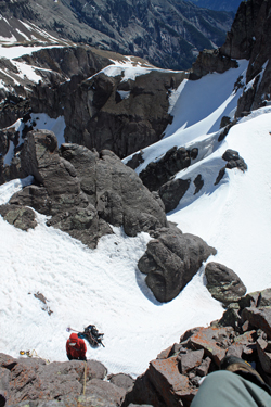 some photos and slung a just in case Spectra cordellete around a summit boulder in addition to the sling already in place. I just was not enthused about using what Perceived was likely last year's sling that had absorded a full dose of winter UV exposure. some photos and slung a just in case Spectra cordellete around a summit boulder in addition to the sling already in place. I just was not enthused about using what Perceived was likely last year's sling that had absorded a full dose of winter UV exposure.
Ed lowered me from the top and we exchanged positions so that I could belay his climb, now with the rope in a top rope position. Up he went and soon enough he too had achieved the high point of Teakettle, giving us both a 1 for 2 record for this weekend's climbing adventure. I lowered Ed and we re-packed the gear to make our way back down before the snow got too soft. We may have driven close but it still took us 5 hours to summit and we knew that some postholes would await us on our return route. The upper snowfield proved to be getting a bit soft while the next one down was still prime neve, still points only terrain. The snow that covered the ice in the black gully as now melting in the sun, but there was still just enough snow and nearby rock to allow a sneak route without having to rig the drop over the 20 feet of ice.
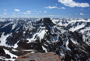 We put up with 250 feet of vertical descent through talus before we picked up the snow that we originally planned to climb and which we knew would lead to the basin floor, perfect heel stepping snow with not a posthole until we were just about out of the basin. From there is was grass and a bit of bog before we dropped enough elevation to hit the road and walk all of ten minutes to the truck. Teakettle made up for our near miss on Dallas and gave me Centennial #91 on the way to the top 100. We put up with 250 feet of vertical descent through talus before we picked up the snow that we originally planned to climb and which we knew would lead to the basin floor, perfect heel stepping snow with not a posthole until we were just about out of the basin. From there is was grass and a bit of bog before we dropped enough elevation to hit the road and walk all of ten minutes to the truck. Teakettle made up for our near miss on Dallas and gave me Centennial #91 on the way to the top 100.
|
