2006 Apolobamba Expedition
Travel to La Paz & Preparation for the Apolobamba
La Paz to Pelechuco, July 17, 2006:
The alarm went off too early, 4 a.m. We had to be ready to go at 5 and we knew Roberto would be outside waiting a half hour before the set time. But for a few small items, all the gear was packed from the night before though we had separated out our stay behind gear and there was little to be left behind as our pre-trip optimization had weeded out most of the "luxury" items. We lugged the bags down the steps and went outside to see if our ride was waiting and of course, it was.
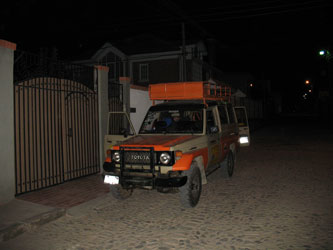 The gear all went into the rear of the Land Cruiser along with the trip's food supply, which was already loaded from the night before. I asked if I could occupy the "asiento del teniente" and Roberto readily agreed. This would make photos along the way a great deal easier and allow for the over the hood,"you are there", shots that I like to take. We got everything loaded and were off to Dr & Sra. Berrios place to drop the leave behind gear and confirm that all was well for the trip. Roberto was issued with traveling funds and within a few minutes we were off for the Apolobamba. The gear all went into the rear of the Land Cruiser along with the trip's food supply, which was already loaded from the night before. I asked if I could occupy the "asiento del teniente" and Roberto readily agreed. This would make photos along the way a great deal easier and allow for the over the hood,"you are there", shots that I like to take. We got everything loaded and were off to Dr & Sra. Berrios place to drop the leave behind gear and confirm that all was well for the trip. Roberto was issued with traveling funds and within a few minutes we were off for the Apolobamba.
La Paz is unlike Lima in that the streets are actually quiet in the hours before dawn and have less of a "Soylent Green" atmosphere. We hit the deserted Prado and drove uptown to the Berrios' warehouse about midway up the hill to El Alto. There we picked up some tents and cook gear that had been set aside for us to retrieve before we made our way to El Alto to pick up Mario and a guide for the drive to Pelechuco. We topped the canyon rim and after a few turns through the maze of streets, we arrived at a transit stop and picked up Mario and the guide. Introductions went all around and we found that our highway guide was the cousin of Elrochio, a guide we climbed with in the Condoriri five years before.
 The trip to Pelechuco would take 12 hours and travel first along the eastern shore of Lake Titicaca, then, before arriving at the Peruvian frontier, turn north east and climb into the hills, drop into a river valley and finally cross over the Apolobamba to arrive in Pelechuco. The extra guide came along to ensure that we made it to Pelechuco, in other words, there are no road signs when the going gets tough, well this guy had been to Pelechuco . . . once . . . about three years before! The trip to Pelechuco would take 12 hours and travel first along the eastern shore of Lake Titicaca, then, before arriving at the Peruvian frontier, turn north east and climb into the hills, drop into a river valley and finally cross over the Apolobamba to arrive in Pelechuco. The extra guide came along to ensure that we made it to Pelechuco, in other words, there are no road signs when the going gets tough, well this guy had been to Pelechuco . . . once . . . about three years before!
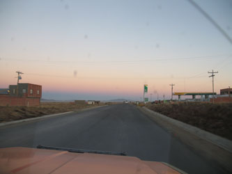
With a full crew aboard, we cut to the main highway that leaves El Alto to head in the general direction of Sorata. We stopped at the obligatory toll facility on the edge of town, paid our toll and began to leave the urbanizacions behind us. The payment of the toll is always an amusing affair as the toll collectors/national police are always in a glum mood and the driver seems obligated to avoid all eye contact and respond to any inquiries with a grunt. With the required grunt completed, we were off.
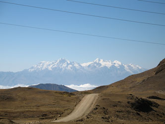
The first portion of the trip is over a two lane highway that we were familiar with from our trip to Condoriri in 2001. We passed along the front of the Cordillera Real as Huayna Potosi and the Cabeza de Condor shone in the early morning sun. We passed small settlements along the way, each marked by the mandatory unfinished extruded red brick two and three story structures, each festooned with a crown of reinforcing bars reaching for the next story, likely never to come. We were told that the reason for the "unfinished" look is not a failure to finish but a matter of different tax rates for structures under construction as compared to those finished.
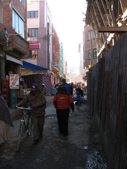 We pulled into the town of Achacachi and Roberto indicated that it was time for some breakfast. Achachachi is not a big place, probably 20 blocks long or so with a central square and streets crowded with the usual market stalls ad tiendas. We parked the Cruiser on the main thoroughfare, secured the doors and made our way about two blocks down a small side street to a small tienda that had three tables and a couple of chairs for each. The gals out front were boiling water and selling coffee so we took a seat inside for the first test of our alimentary canals. The coffee was strong and the rolls were fresh, we enjoyed them while the passing locals stopped to gawk at the two gringos who had obviously dropped in from somewhere far far away. Needless to say we were the only gringos in town that week. We finished breakfast and wandered back to the Toyota with a short stop at the banos publico where for 1/2 B you are issued a few squares of toilet paper and shown to the appropriate opening. Same routine as elsewhere, position feet on small raised foot prints and squat, pay no mind to the fact that there is no door, you need to pay attention to your balance! We pulled into the town of Achacachi and Roberto indicated that it was time for some breakfast. Achachachi is not a big place, probably 20 blocks long or so with a central square and streets crowded with the usual market stalls ad tiendas. We parked the Cruiser on the main thoroughfare, secured the doors and made our way about two blocks down a small side street to a small tienda that had three tables and a couple of chairs for each. The gals out front were boiling water and selling coffee so we took a seat inside for the first test of our alimentary canals. The coffee was strong and the rolls were fresh, we enjoyed them while the passing locals stopped to gawk at the two gringos who had obviously dropped in from somewhere far far away. Needless to say we were the only gringos in town that week. We finished breakfast and wandered back to the Toyota with a short stop at the banos publico where for 1/2 B you are issued a few squares of toilet paper and shown to the appropriate opening. Same routine as elsewhere, position feet on small raised foot prints and squat, pay no mind to the fact that there is no door, you need to pay attention to your balance!
 We mounted up and were soon again on our way north. The road rises and falls as it traverses the shore of the lake, giving views of fishing activity on the left and more of the small subsistence farming patches on the right. All along the road, the locals are going about their work, kids watching small herds of goats, men tilling the fields using a bullock drawn plow and women walking along the road with large loads bound for market. We mounted up and were soon again on our way north. The road rises and falls as it traverses the shore of the lake, giving views of fishing activity on the left and more of the small subsistence farming patches on the right. All along the road, the locals are going about their work, kids watching small herds of goats, men tilling the fields using a bullock drawn plow and women walking along the road with large loads bound for market.
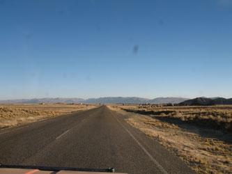
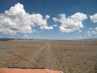
 As we approached the Peruvian frontier, the road cut inland and we traveled through rolling hills before arriving in the vicinity of Escoma and leaving the shores of Lake Titicaca behind us. The course along the river extends for a good number of miles before the road cuts again up onto ridges and comes to a signed juncture . . . the right hand fork leads to Charazani and the left to Pelechuco. The distance to Charazani is much less, making for a shorter ride back to la Paz than the ride in. We went left toward Pelechuco and dropped into another river valley, this time running right along the frontier with Peru, located on the crest of the hill immediately to our northwest. The topography begins to climb and there is little if any sign of agriculture, instead one now begins to see herds of llamas and alpacas, with only a few scattered potato plots here and there. The rise in elevation brought us out onto the classic alto plano where the desert stretches for miles in every direction and the prevously discenable dirt road degrades to double tracks, each competing for the attention of the driver. As we approached the Peruvian frontier, the road cut inland and we traveled through rolling hills before arriving in the vicinity of Escoma and leaving the shores of Lake Titicaca behind us. The course along the river extends for a good number of miles before the road cuts again up onto ridges and comes to a signed juncture . . . the right hand fork leads to Charazani and the left to Pelechuco. The distance to Charazani is much less, making for a shorter ride back to la Paz than the ride in. We went left toward Pelechuco and dropped into another river valley, this time running right along the frontier with Peru, located on the crest of the hill immediately to our northwest. The topography begins to climb and there is little if any sign of agriculture, instead one now begins to see herds of llamas and alpacas, with only a few scattered potato plots here and there. The rise in elevation brought us out onto the classic alto plano where the desert stretches for miles in every direction and the prevously discenable dirt road degrades to double tracks, each competing for the attention of the driver.
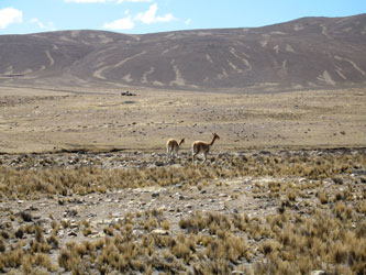
 We passed groups of grazing vicuna, many close to the road and seemingly unconcerned with our passing. The road took us up and down through various arroyos and across cobbled washes before leading us through a line of uniformly spaced posts extending off in either direction. Roberto was unsure of the proper path as was the other guide so we went a bit further, probing tracks to the left and right, all the while chatting about the location of the Peruvian frontier. There was a village ahead but that was not an option as we discerned the fact that we really needed to head back to the other side of the posts before we had some explaining to do. We passed groups of grazing vicuna, many close to the road and seemingly unconcerned with our passing. The road took us up and down through various arroyos and across cobbled washes before leading us through a line of uniformly spaced posts extending off in either direction. Roberto was unsure of the proper path as was the other guide so we went a bit further, probing tracks to the left and right, all the while chatting about the location of the Peruvian frontier. There was a village ahead but that was not an option as we discerned the fact that we really needed to head back to the other side of the posts before we had some explaining to do.
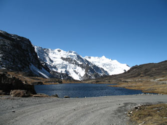 We chose a new direction and after a bit came upon a strong set of tracks leading in the right direction. Then we came across the village of Ulla Ulla, both a signed landmark and conveniently located in the correct country, so we knew we were back on track for Pelechuco. Our course strengthened further into a good single dirt road as we crossed over the lower limits of alluvial fans pushing down from the snow covered Apolobamba, now getting closer by the minute. We forded the Rio Cololo coming from the flanks of Cololo and then passed the final army checkpoint at the Antaquilla junction before heading for Paso Pelechuco that crosses the divide separating the northern half of the Apolobamba from the southern. Checkpoint cleared, we traveled along the long glacial Lago Cololo and then climbed to the summit of Pelechuco Pass. The road is remarkable, a single lane that climbs to over 15,000 feet and then drops through a series of switchbacks into the valley on the other side. We stopped at the top so Roberto could pay homage to Pachamama on behalf of the group. We chose a new direction and after a bit came upon a strong set of tracks leading in the right direction. Then we came across the village of Ulla Ulla, both a signed landmark and conveniently located in the correct country, so we knew we were back on track for Pelechuco. Our course strengthened further into a good single dirt road as we crossed over the lower limits of alluvial fans pushing down from the snow covered Apolobamba, now getting closer by the minute. We forded the Rio Cololo coming from the flanks of Cololo and then passed the final army checkpoint at the Antaquilla junction before heading for Paso Pelechuco that crosses the divide separating the northern half of the Apolobamba from the southern. Checkpoint cleared, we traveled along the long glacial Lago Cololo and then climbed to the summit of Pelechuco Pass. The road is remarkable, a single lane that climbs to over 15,000 feet and then drops through a series of switchbacks into the valley on the other side. We stopped at the top so Roberto could pay homage to Pachamama on behalf of the group.
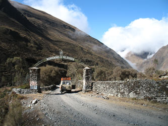
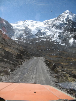 With thanks given for our safety so far, we made our way down the twisting road, taking in the vista of the Katanica peaks that line the northern side of the road. That view left now doubt that there would be some remarkable climbing in this range and that we would not likely be disappointed over the course of our travels. We descended from nearly 15,500 feet to almost 11,000 before coming under the arch that announced our arrival in Pelechuco, a town of about 800 souls, very far removed from our starting point that morning. With thanks given for our safety so far, we made our way down the twisting road, taking in the vista of the Katanica peaks that line the northern side of the road. That view left now doubt that there would be some remarkable climbing in this range and that we would not likely be disappointed over the course of our travels. We descended from nearly 15,500 feet to almost 11,000 before coming under the arch that announced our arrival in Pelechuco, a town of about 800 souls, very far removed from our starting point that morning.
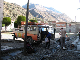
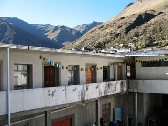
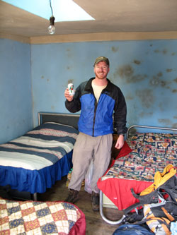
 We pulled into the main square of the town and took on the task of finding accommodation. The hotel of choice wa closed, leaving the other as our only option. We took the grand tour and scoped out the room. Three beds, broken windows, and a pattern of mold on the wall that at first glance looked like a Rorschach mural. This was the only option so it had to do, regardless. But . . . the folks who lived there were a friendly lot, the kids did their homework in the inner courtyard while the elders went about cleaning vegetables and miscellaneous other chores. With room in hand, we unloaded the Toyota and stockpiled the whole of the expedition's food and gear in our room. We pulled into the main square of the town and took on the task of finding accommodation. The hotel of choice wa closed, leaving the other as our only option. We took the grand tour and scoped out the room. Three beds, broken windows, and a pattern of mold on the wall that at first glance looked like a Rorschach mural. This was the only option so it had to do, regardless. But . . . the folks who lived there were a friendly lot, the kids did their homework in the inner courtyard while the elders went about cleaning vegetables and miscellaneous other chores. With room in hand, we unloaded the Toyota and stockpiled the whole of the expedition's food and gear in our room.
 The next order of business was to make contact with the arriero, Alcides who according to the locals was not in town. The word was that he was possibly a day or so out and would not arrive in Pelechuco for anther day or two. Just great we thought, we get to cool our heels in Pelechuco until he arrives in a day, two days, three? No point in getting hyper at this point, he knew we were coming and he would arrive, we just did not know when and there was nothing we could do about it. The folks who ran the hotel had a small restaurant and served the customary Andean highland dinner . . . rice, chicken and potatoes. This is standard fare in the highlands, so if you are not a fan of those three items, you are in trouble. The meal was really good, especially when chased down with an Orange Crush. The next order of business was to make contact with the arriero, Alcides who according to the locals was not in town. The word was that he was possibly a day or so out and would not arrive in Pelechuco for anther day or two. Just great we thought, we get to cool our heels in Pelechuco until he arrives in a day, two days, three? No point in getting hyper at this point, he knew we were coming and he would arrive, we just did not know when and there was nothing we could do about it. The folks who ran the hotel had a small restaurant and served the customary Andean highland dinner . . . rice, chicken and potatoes. This is standard fare in the highlands, so if you are not a fan of those three items, you are in trouble. The meal was really good, especially when chased down with an Orange Crush.
 Following dinner, we killed a bit of time watching the goings on in the town square and then hit the room for some shut eye. I managed to fill in the trench that crossed the center of the mattress with a semi inflated sleeping bag pad and was soon asleep, but not for long. Alcides, it turned out, was well aware of our arrival and had hiked 8 miles and crossed a 15,000 foot pass to meet with us around 10 p.m. We sat around a table in the restaurant and discussed the plans for the trip and his plans for covering our needs while still having to get back to a trekking group he was bringing north from Curva. The other group was just one day out so we came to an agreement that we would heft sufficient loads to allow us to cover about 6 miles the next day, during the course of which he would pass us, going in the other direction, drop off his group, pick up our remaining gear and meet us the next day before we left for our second night's camp on the edge of Lake Kotani. Following dinner, we killed a bit of time watching the goings on in the town square and then hit the room for some shut eye. I managed to fill in the trench that crossed the center of the mattress with a semi inflated sleeping bag pad and was soon asleep, but not for long. Alcides, it turned out, was well aware of our arrival and had hiked 8 miles and crossed a 15,000 foot pass to meet with us around 10 p.m. We sat around a table in the restaurant and discussed the plans for the trip and his plans for covering our needs while still having to get back to a trekking group he was bringing north from Curva. The other group was just one day out so we came to an agreement that we would heft sufficient loads to allow us to cover about 6 miles the next day, during the course of which he would pass us, going in the other direction, drop off his group, pick up our remaining gear and meet us the next day before we left for our second night's camp on the edge of Lake Kotani.
 It was certainly not "the" plan but it was a plan and it would turn out to work just fine. We would lug a bunch of weight on the first day but we had rested well in La Paz and the scheme was workable. We headed for the room and got a decent night's sleep as we knew we would need it. Meanwhile, Roberto, Mario and the road guide took to the Toyota for the night, not caring to partake in the local lodgings. It was certainly not "the" plan but it was a plan and it would turn out to work just fine. We would lug a bunch of weight on the first day but we had rested well in La Paz and the scheme was workable. We headed for the room and got a decent night's sleep as we knew we would need it. Meanwhile, Roberto, Mario and the road guide took to the Toyota for the night, not caring to partake in the local lodgings.
|
