Peru 2011
Trek: Jampa to Chillca
June 22, 2011
With our summit of Lliani in hand, (and a night of celebration wearing off) the remainder of the trip consisted of covering the more than 30 miles between our camp above Jampa to the trail head at Pitumarca. The trekking groups ordinarily do this in 4 to 5 days, with leisurely mornings and a camp in place by midafternoon. We conferred with Leo and decided that we would cover the ground in two long days with a final push on the third morning. This pace would provide two 12 to 15 mile days and a 6 mile hustle at the end. This distance was fine with us as we would descend most all of the way, dropping from an elevation of about 15,500 feet to just around 12,000 feet. The distances were also about as far as Leo and Rocque were comfortable pushing the pack train in a day, given the weight involved.
 We breakfasted by 7 a.m. and aimed to have the camp broken and ready to go no later than 8 a.m. The tents came down and breakfast was on the light side, but were were all ready to get a move on and drop some of the altitude that, although fun, was quietly beating the heck out of the gringos. We knew from our prior day's climb, that we would be following the river valley down, literally all the way to Pitumarca. We also knew there would be established trail for the whole of the route and that the lower parts would likely be well used by trekking groups making the circuit around Ausangate. We breakfasted by 7 a.m. and aimed to have the camp broken and ready to go no later than 8 a.m. The tents came down and breakfast was on the light side, but were were all ready to get a move on and drop some of the altitude that, although fun, was quietly beating the heck out of the gringos. We knew from our prior day's climb, that we would be following the river valley down, literally all the way to Pitumarca. We also knew there would be established trail for the whole of the route and that the lower parts would likely be well used by trekking groups making the circuit around Ausangate.
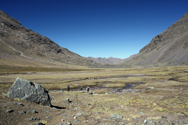
 We left camp and passed by Jampa after a mile, seeing not a soul but catching the attention of the dogs that guard every herder's compound. We walked on, the barking fading in the background, and made one of multiple river crossings, using the large flat stone steps placed by the locals for the same reason. Once below Jampa, the valley opened up with a wide floor, every bit of a half mile across. Our route stuck to the eastern flank, however the pack train took the west side and seemed to have as good a route, based upon their pace. The valley floor was fairly dry in the upper reaches but as we descended we came upon more and more wet ground where side streams had been dammed and channeled to wash over a wide area, likely to improve the grazing for the herds of alpaca that we passed by. We left camp and passed by Jampa after a mile, seeing not a soul but catching the attention of the dogs that guard every herder's compound. We walked on, the barking fading in the background, and made one of multiple river crossings, using the large flat stone steps placed by the locals for the same reason. Once below Jampa, the valley opened up with a wide floor, every bit of a half mile across. Our route stuck to the eastern flank, however the pack train took the west side and seemed to have as good a route, based upon their pace. The valley floor was fairly dry in the upper reaches but as we descended we came upon more and more wet ground where side streams had been dammed and channeled to wash over a wide area, likely to improve the grazing for the herds of alpaca that we passed by.
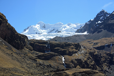
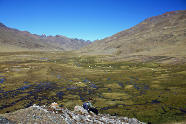
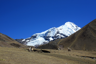 While the first few miles of valley were scenic, our first real mountain views would not come until we reached the side valley that provides access to the Ausangate base camp on the west side of the mountain. However, we first came to the point where the ridge of Mariposa finally succumbed to the valley and where we finaly got a view of the opposite side of this peak and the substantial glacier guarding an appraoch. We trekked on through some very wet flats, populated by a herd of alpaca probably a couple hundred in number. A large trekking group was also camped there, large as in no less than fifteen tents, multiple mess tents and more than a little bit of local help. We skirted their camp, passed through the alpaca herd and continued on to where the valley that leads to Ausangate proper tapers into the main valley. The view of Ausangate was wonderful and it is no wonder that climbers are drawn to this peak for the whole of their expeditions. While the first few miles of valley were scenic, our first real mountain views would not come until we reached the side valley that provides access to the Ausangate base camp on the west side of the mountain. However, we first came to the point where the ridge of Mariposa finally succumbed to the valley and where we finaly got a view of the opposite side of this peak and the substantial glacier guarding an appraoch. We trekked on through some very wet flats, populated by a herd of alpaca probably a couple hundred in number. A large trekking group was also camped there, large as in no less than fifteen tents, multiple mess tents and more than a little bit of local help. We skirted their camp, passed through the alpaca herd and continued on to where the valley that leads to Ausangate proper tapers into the main valley. The view of Ausangate was wonderful and it is no wonder that climbers are drawn to this peak for the whole of their expeditions.
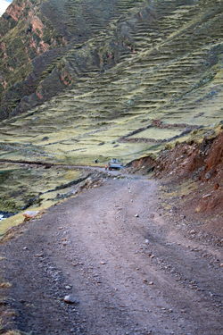
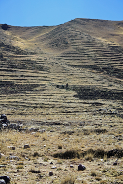 We stopped to take a few photos and then kept moving, we had ground to cover . . . The valley alternated between wet and dry, depending on in feeder streams and the industry of the locals in cutting irrigation ditches. Along the way we passed alpaca corrals, built of local fieldstone, and started to see the beginnings of terraced farmland where potatoes had been grown, likely since before Columbus set foot on this side of the world. Our trail also intersected with a "post Columbian" gravel road that Domingo noted would be our route all the way to Pitumarca. Our map, more than a few years old, did not show the road progressing much more than a few miles in this direction from the limits of Pitumarca, but here we were . . . still about two days out . . . and we had hit road for sure. We stopped to take a few photos and then kept moving, we had ground to cover . . . The valley alternated between wet and dry, depending on in feeder streams and the industry of the locals in cutting irrigation ditches. Along the way we passed alpaca corrals, built of local fieldstone, and started to see the beginnings of terraced farmland where potatoes had been grown, likely since before Columbus set foot on this side of the world. Our trail also intersected with a "post Columbian" gravel road that Domingo noted would be our route all the way to Pitumarca. Our map, more than a few years old, did not show the road progressing much more than a few miles in this direction from the limits of Pitumarca, but here we were . . . still about two days out . . . and we had hit road for sure.
We road marched for another couple of miles before the village of Chillca came into sight up ahead. By this point, we were passing small groups of campesinos working the terraces on the eastern flank of the valley, tilling the ground and burning off piles of vegetation. We entered Chillca and took a break on the road above the school. The kids were engaged in some sort of physical education as they were lined up and raced back and forth 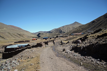 across the soccer field in groups of six to eight. We watched and casually commented on whether the girl in yellow stripes would win the next leg of the race or whether green skirt, who was on yellow stripes' heels would prevail in the next round. Our path led us through Chillca and up a hill on the far side where we passed more locals and a road survey crew before dropping down to the intersection point of our main valley and the valley that leads out and around the southern flank of Ausangate and back to Pacchanta. across the soccer field in groups of six to eight. We watched and casually commented on whether the girl in yellow stripes would win the next leg of the race or whether green skirt, who was on yellow stripes' heels would prevail in the next round. Our path led us through Chillca and up a hill on the far side where we passed more locals and a road survey crew before dropping down to the intersection point of our main valley and the valley that leads out and around the southern flank of Ausangate and back to Pacchanta.
We did not really realize it at this point but the nature of the valley was changing. The start of our hike had been through a wide flat valley, often a half mile wide at its base. However now the valley had morphed into a canyon with 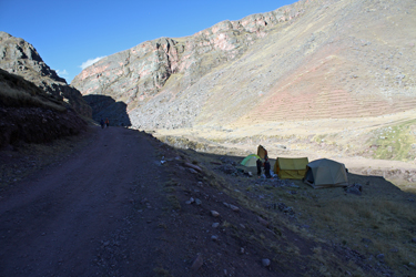 steep sides and a narrow base, wide enough for the river and the road but little more. We continued downstream and from the junction point below Chillca went perhaps another half mile before Leo and Rocque selected a flat spot off to the side of the road for that night's camp. The horses were unpacked and soon enough the regular routine of getting individual and group tents erected was under way. While Domingo set about a late afternoon snack, we took the opportunity to catch a bath in the river, the first cleaning effort since the hot pools of Pacchanta. steep sides and a narrow base, wide enough for the river and the road but little more. We continued downstream and from the junction point below Chillca went perhaps another half mile before Leo and Rocque selected a flat spot off to the side of the road for that night's camp. The horses were unpacked and soon enough the regular routine of getting individual and group tents erected was under way. While Domingo set about a late afternoon snack, we took the opportunity to catch a bath in the river, the first cleaning effort since the hot pools of Pacchanta.
 As the day closed, we watched a grading crew approach up the road, working to widen the road in accordance with row of stones placed to mark the new centerline and the various marks made by piles of lime poured to mark the desired edge of the improved road. However, as a former construction foreman, I found the tirade of the foreman most interesting though I understood not a word of it. Yes, a tail chewing in Quechua includes all of the same mannerisms, gestures and intonations as one in English. I shook my head and he shook his, must have been some foreman to foreman subliminal understanding between the two of us as to his crew's performance. As the day closed, we watched a grading crew approach up the road, working to widen the road in accordance with row of stones placed to mark the new centerline and the various marks made by piles of lime poured to mark the desired edge of the improved road. However, as a former construction foreman, I found the tirade of the foreman most interesting though I understood not a word of it. Yes, a tail chewing in Quechua includes all of the same mannerisms, gestures and intonations as one in English. I shook my head and he shook his, must have been some foreman to foreman subliminal understanding between the two of us as to his crew's performance.
Night came and with it the stars of the southern sky. I'm not celestially gifted so I settled for picking out the Southern Cross as my only known constellation. As the last of the sun faded behind the mountains, we took in the stars for a few minutes before heading for the tents to rest up before the next day's trek.
|
