|
||||||||||||||||||
|---|---|---|---|---|---|---|---|---|---|---|---|---|---|---|---|---|---|---|
Mummy MountainJanuary 6, 2003 - Lawn Lake Trail
Living in Cheyenne or Laramie provides a good view of the peaks of the Mummy Range, located in the northern portion of Rocky Mountain National Park. I commute from Cheyenne to Laramie and see them for the majority of the ride but until now, we had not ventured into this area relatively close to home. We decided it was well past time to start climbing the 13’ers of this “overlooked” range. The forecast originally called for a period of good weather so we intended to make a high camp and climb several of the Mummy Range peaks. However, the forecast did not come to fruition and on Sunday morning we could see a wall of cloud obscuring our destination and the on line weather station at Corona Pass was indicating mist and snow on the way. So much for camping. We headed to Estes in the late afternoon instead, planning to get a room and make an early start the next morning. We figured the weather would determine the nature of the climb, recon of the Mummy approach trails or an actual climb, the morning weather would tell.
Our arrival in Estes was coordinated with fresh wet snow. Our decision to bag the camping was confirmed if for no other reason than the 6-mile approach hike surely would have been miserable. We got a room, followed by dinner at the Grumpy Gringo, Estes’ Mexican joint on the edge of town and a traditional pre climb feed for our group. Given a forecast calling for poor weather the following morning, we planned a late, 6 a.m., start with a fall back plan of going to the rock gym in Fort Collins if conditions were just lousy.
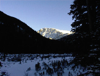
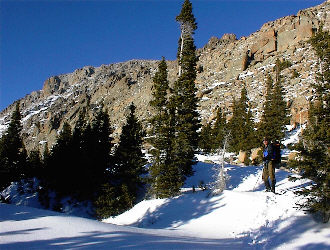
The next morning greeted us not with cloud and snow but with a brilliant showing of stars and a relatively warm temperature, in Estes at least. We made a circuit of the local Quick Marts, none of which were open and settled for some pre climb donuts (at least the bakery in Estes still makes donuts in the a.m.) Then into the park and up to the Lawn Lake Trail trailhead just off the Fall River Road. We were the only ones in the parking lot and after some initial but minimal lollygagging around; we hit the trail at 6:15. The trail initially leads up a series of switchbacks and was slick from ½ inch of fresh snow, now covering any icy patches previously visible. We kept the pace slow and constant, stopping to shoot goo, eat, and drink at bit at regular intervals.
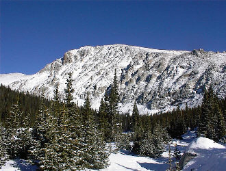
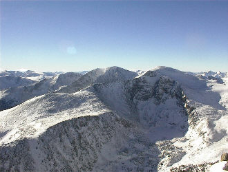
Mummy Mountain was not visible early on in the hike but by the time the sun started shining on the peaks, we were treated to a brilliantly lit view of Ypsilon Mountain before taking the crook in the drainage to head for Mummy. By this time we also had enough light to note the degree of damage to the creek bed brought on by some huge amount of water. Though we knew nothing of it at the time, we would be walking along an area devastated by the Lawn Lake Dam failure in 1982. (Lawn Lake Flood) Before long, we reached the three campsites, located mid way to Lawn Lake, we were able to see Mummy and its steep southwest face, cut by numerous couloirs and highlighted by multiple rock buttresses. We could see the upper portion of the route we had observed from a distance and knew that we had a few more miles of approach before we would be able to turn to the east and ascend the southeast ridge. By the time we left the area of the Gold Banner campsite, we were still walking in boots and able to stay atop a compacted trail but after another mile or so we were forced to put on the snowshoes after starting to posthole in snow now approaching two feet in depth. We continued our steady progress to the juncture of the Lawn Lake trail and the Black Canyon trail, where we were also able to observe Hague’s Peak, the saddle connecting Hague’s and Fairchild Mountain, and the impressive southwest face of Mummy Mountain, right behind and above us.
Our next challenge was to find an appropriate way onto the southeast ridge of Mummy to make for the summit. We still had a 2500-foot ascent to complete so we were looking for the most energy efficient option available. We took the Black Canyon trail toward the east but after a mere 100 feet, the trail was completely drifted over. We could see the rock slope just to our left but really wanted to climb a bit through the trees toward a saddle before getting on the rock proper. The southwest face of Mummy goes from a couloir hatched wall to a much more mellow ridge as one goes toward the east. Our goal was to find a happy medium, enough rock to move on comfortably but without so much snow in the rock to make the ascent too dangerous or tiring. We traversed up through the trees, sticking to mellow ground until we reached the vicinity of the saddle after which we cut north and climbed to the base of the talus and boulder strewn slope. Had the snow been steep instead of flat lying, we would have had an avalanche concern, as most of the flat open areas quickly collapsed as we crossed them, lots of whumpfing snow up there . . .
We made the base of the rock slope and ditched the snowshoes and other extra weight. So far, the weather had been simply incredible, the sun was warming us and we opted to climb on even though it was already 11:30 and the possibility of an after dark conclusion of the climb was more than just probable. We were comfortable with this option due to the weather, the easily followed and mostly packed trail in to this point, and possession of sufficient gear to bivy in the event of some totally unforeseen circumstance. We marked the gear drop with a wand and GPS waypoint and headed up the slope in the slow but deliberate scramble mode. We made the first skyline and found ourselves in a high bowl, mostly blown free of snow, except for one very wind hammered snow slope crossing. We crossed the slope one at a time, even though it was shallow and pretty tame with regard to slope angle. Nevertheless, it was a winter climb; you carry the wands, the extra gear, and treat all the slopes with respect.
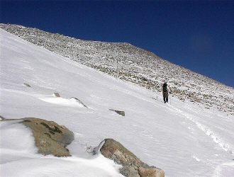
The far side of the slope provided us with another seemingly small rise but by this point, we figured out that the game here was the same one we played on Mt Lady Washington, a week earlier. The slope looks tame and “not that far” but the altimeter and the map are both insisting there is more than a thousand feet of vertical right there in front of you. My GPS said 11,700 and the summit is at over 13,400, but our eyes just were not confirming the facts. We started climbing and eventually made the next skyline, weaving here and there so as not to disturb a group of about six bighorn sheep, grazing around the 12,000-foot line. Since the snow was mostly blown clear, climbing was beginning to degrade to a relatively mindless uphill slog up between some boulders and talus.
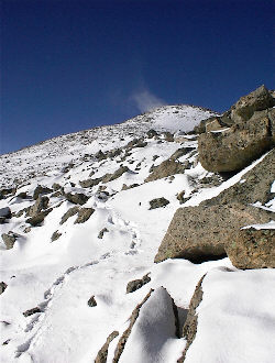
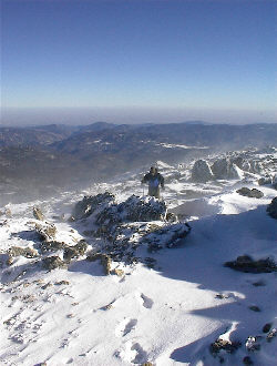
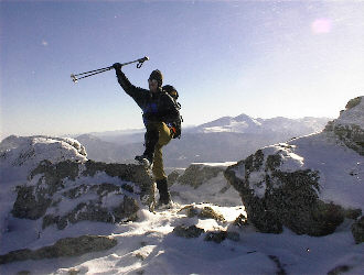
The second skyline did however give us a view of what had to be getting close, the summit. We took a Goo break and then headed off, this time rock hopping and connecting the rocks with patches of wind hammered snow. The obvious summit, of course, turned out to be a false summit but it did provide a view of the real thing, just another 15 minutes further along the ridge crest. We reached the summit at 2:00 and with us came the wind. Our timing had been perfect, just a bit later and instead of having small snow vortices whipping around, we would have had to walk face into growing the ice pellet laden wind. Our summit time was limited and after scoping out the other 13’ers of the Mummy Range, we started heading down and out.
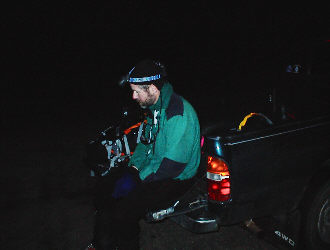
The segments of the down climb fell into place as we retraced our path across the small false summit, back to the second skyline point and down past the sheep to the flats leading to the ridge’s southwest side down climb. The climb down the rocky slope was uneventful and we picked up the occasional wands placed on the ascent to make where we had come through a particular band of rock or other minor obstacle. The gear cache was located; water and beef jerky consumed, and before long we were again on the snowshoes for the trip to the known trail juncture below. At the junction, we again stopped to eat, drink, and adjust layers it was now 4:00 and we were going to meet darkness before we made it back to the car. Our trip down the Lawn Lake Trail was fast with but still we continued our schedule of short few stops to take a bit of water, a small snack or adjust layers. We kept the snowshoes on well past where we found them necessary earlier in the day but by doing so, we were relieved of any need to stay centered on the packed track, a proposition made tougher by the dark and being a bit tired. Eventually, about two miles from the truck the shoes came off, and since we were now going to have to think about foot placement and icy patches, we opted for the headlamps in lieu of the moonlight, which had been sufficient up until that point. We made the car at 6:40, having not seen another party all day and scoring a single day winter climb of Mummy Mountain. The trip distance totaled about 15 miles with approximately 4775 feet of elevation gain.
|
