|
||
|---|---|---|
Pacific Peak (Winter)January 30, 2011 - Pacific Peak West Ridge (ascent) & North Ridge (descent) from Mayflower Gulch
Bob and I climbed the West Ridge of Pacific Peak in August 2008 and I really did not expect to repeat the route but . . . something about a repeat in January had the pull needed to fight the traffic of I-70 and put us at the Mayflower Gulch trail head on a bluebird Sunday morning.
The ditch road probably takes a mile or so to lead around the base of Mayflower Hill before coming to a second concrete control structure. This was our exit and yes, the group that cut a wonderfully compact snowshoe trench that far, took the same exit as I had hoped they would. Their compacted track now turned and continued up the valley, leading us to the base of a rise that from a distance seems to the final climb before
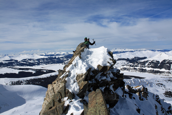
We chose to go up and over a number of the knife edge ridge sections over the course of the lower 2/3 of the climb. At that point, we cut off the ridge proper and hung down the slope a ways, a hundred feet here and there, fifty feet in other places. We climbed on and soon came to a snow slope that promised to be fun. The vertical was likely only 30 feet or so but the angle was every bit of 60 degrees, Enough to allow you to place the axe with one hand and steady oneself with the other hand resting on the slope before you. I took We sat on the summit for perhaps 15 minutes, the wind coming and going before Bob had had his fill (I'm Bob's opposite . . . I am an eat a power bar and bail kind of summitter) We re-crossed the gap between the two summits and with the wind starting to really bite at the face, made our descent down the North Ridge for about 2/3 of the distance to the The climb took us 6 hours to make the ascent and 4 to make it back to the car from the summit. The route was made easier by the unintentional, but still very much appreciated, track set the day before by the previous day's group. Over all a good summer route and an even better January ascent for an experienced group comfortable with the exposure and able to make reasonable time over such terrain.
A summer climb of the West Ridge of Pacific. . .
|

 We left Cheyenne the night before and overnighted at the Super 8 after a steak dinner at Quincy's in Leadville. The room was broiling as usual and the thermostat nowhere to be found, but the digs were clean and sufficient for a short overnight. The alarm went off at 5:30 and after a stop for coffee and a cinnamon roll we were off to the Mayflower Gulch trail head. By 7:00 we were on the trail and headed for the West Ridge, a route we could see off in the distance with the early light of what we hoped would remain a bluebird day in the mountains.
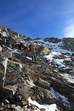 Rather than going up the gulch proper and cutting across through the willows to the avalanche terrain trap that lies between the foot of Mayflower Hill and the toe of Atlantic, we opted for the flat ditch road the circles the opposite base of Mayflower. I'd read of this route a few years ago, used it to get to Crystal and this morning figured it would avoid the avi trap and give us a non willow option. We cut across the stream control
 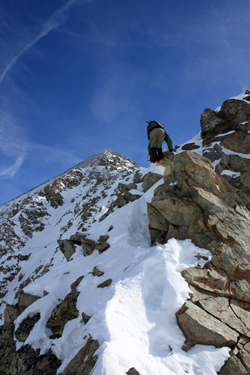 structure and cut up the hill until I spotted the tree cut that loops around to the road proper. The area had obviously gotten a great deal of use the previous day as there were ski and snowshoe tracks all over . . . finding the tree cut was a cinch.
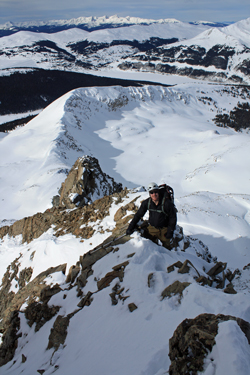 arriving at the base of the West Ridge. Unfortunately, the "trail crew" cut off to the right, likely aiming for Crystal and leaving us to pack our own trail from that point on. We easily traversed the rolling terrain that lies before the ridge that connects the terminus of Mayflower Hill to the base of Pacific's West Ridge and then picked an ascent route that would avoid the most obvious avi run outs and give us a rock route if we started to question stability of the snow under foot.
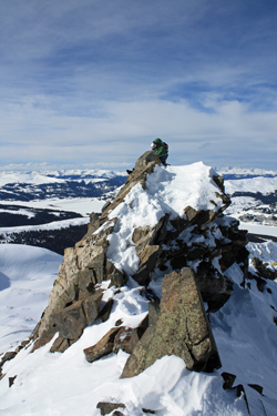 We didn't encounter any signs of loose snow and our ascent up to the base of Pacific's ridge was soon over with. We found a wind sheltered spot behind some rocks to assess the ridge and divvy up the rope and some climbing gear that we figured we might have need for as we climbed. Bob and I had been up the ridge in the summer but we knew this would be a bit different. G suggested that Bob take the lead, pick a good class 3 winter route and we'd follow. We were off.
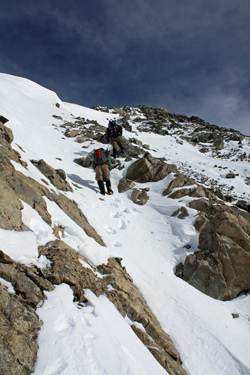 The route Bob chose was similar to that we did a few years back, not attacking the ridge directly at first but instead cutting around to the southern side for just a bit at the start. We climbed class 3 terrain and found much of he route clear enough of snow to avoid the frustration of a leg breaker hidden beneath a crusty white layer. We climbed past the first hump and then took to the ridge proper. I remembered
 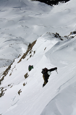 the route but with a winter's coat, it proved a bit more deserving of careful foot placement. The fun part of this ridge is that if one sticks to the ridge proper, the terrain can and will go class 4 and low class 5 in a spot or two. There is enough exposure to keep the climb exciting but there also a go arounds to avoid the toughest sections if one wishes to.
 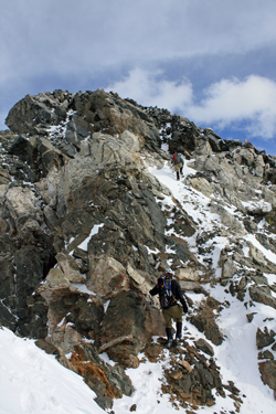 the lead and after I completed the climb, G and then Bob followed, one at a time. From the top of the slope we took the ridge directly to the false summit that is separated from the summit proper by the upper reach of the North Couloir ice/snow route. We down climbed to the terminus of the couloir and then up perhaps 75 vertical to the summit proper.
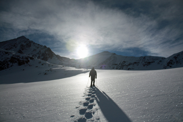
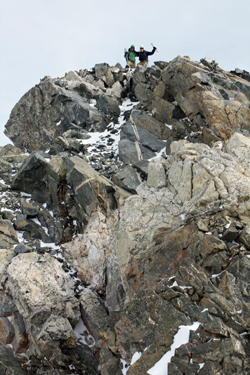 saddle connecting Pacific to Crystal. We then cut down some frozen scree to the snow filled flats where we again donned our snowshoes to head for the car. We trended toward Mayflower hill and then zigged back down to re-connect with our approach route just below where we began our climb to gain the foot of the West Ridge. From there it was just a fast trek back down to tree line, onto that oh so well compacted trail and then out the ditch road to the trail head proper.